Modena is an unincorporated community in far western Iron County, near the Nevada border in southwestern Utah, United States.

Ames is an unincorporated hamlet in southern Dodge County, Nebraska, United States. As of the 2010 census it had a population of 24.

Enders is an unincorporated community and census-designated place in Chase County, Nebraska, United States. As of the 2010 census it had a population of 42. Although Enders is unincorporated, it has a post office, with the ZIP code of 69027.

St. Libory or Saint Libory is an unincorporated community and census-designated place (CDP) in southeastern Howard County, Nebraska, United States. As of the 2010 census it had a population of 264.
Watkins is an unincorporated community and census-designated place in southeastern Benton County, Iowa, United States. As of the 2010 census, it had a population of 118. Watkins lies along local roads south of the city of Vinton, the county seat of Benton County. Its elevation is 830 feet (250 m) above sea level. Although Watkins is unincorporated, it has a post office, with the ZIP code of 52354, which opened on 15 December 1873.
Sperry is an unincorporated community in central Des Moines County, Iowa, United States. It lies along local roads north of the city of Burlington, the county seat of Des Moines County. Its elevation is 751 feet (229 m). Although Sperry is unincorporated, it has a post office with the ZIP code of 52650, which opened on 5 February 1870.
South Amana is an unincorporated community and census-designated place (CDP) in northern Iowa County, Iowa, United States, and is part of the "seven villages" of the Amana Colonies. As of the 2010 census, it had a population of 159.
Moscow is an unincorporated community and census-designated place (CDP) in Muscatine County, Iowa, United States. As of the 2020 census, the population was 290. It has a post office, with the ZIP code of 52760, which opened on May 1, 1837. The community is part of the Muscatine Micropolitan Statistical Area.

Arminto is an unincorporated community in northwestern Natrona County, Wyoming, United States. It lies along local roads west of the city of Casper, the county seat of Natrona County. Its elevation is 6,053 feet (1,845 m).

Beulah is a census-designated place (CDP) in eastern Crook County, Wyoming, United States, along Sand Creek, a tributary of the Belle Fourche River. According to local residents, the population is 33. When the 2010 census reported the population as 73, the highway sign at the town entrance was changed. In 2012, Beulah residents succeeded in appealing to the Wyoming Governor to remove the new sign and replace it with one that proclaimed the population to be 33.

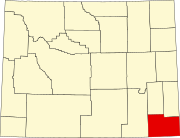
Carpenter is an unincorporated community and census-designated place in southeastern Laramie County, Wyoming, United States. As of the 2010 census it had a population of 94. It lies along WYO 214 east of the city of Cheyenne, the county seat of Laramie County and capital of Wyoming. Its elevation is 5,440 feet (1,658 m). Although Carpenter is unincorporated, it has had a post office since 1907, with the ZIP code of 82054.
Garrett is an unincorporated community in northern Albany County, Wyoming, United States, along the North Laramie River. It lies along local roads north of the city of Laramie, the county seat of Albany County. Its elevation is 6,785 ft (2,068 m), and it is located at 42°6′48″N105°36′36″W. Although Garrett is unincorporated, it once had a post office, with the ZIP code of 82058. The building remains, though is no longer in use. Garrett is also home to River Bridge School, a one-room schoolhouse that is part of Albany County School District #1. Aside from the schoolhouse, the land is privately owned.
Hiland is an unincorporated community in western Natrona County, Wyoming, United States. It lies along the concurrent U.S. Routes 20 and 26, west of the city of Casper, the county seat of Natrona County. Its elevation is 6,004 feet (1,830 m). Although the Hiland post office closed in 2014, it retains a ZIP code of 82638. Hiland is so named because it formed the highest elevation point within the Wyoming portion of the Chicago and Northwestern Railroad: it was originally named Woolton at its founding, with the spelling later changed to Wolton until 1914, when most of Wolton's population moved to Arminto, the new, nearby railhead, and the remaining citizens renamed the town Hiland. As of 2014, the town consisted only of a bar catering to bikers, and an adjacent house.
Horse Creek is an unincorporated community in western Laramie County, Wyoming, United States. It lies between Horse Creek to the north, and the South Fork of Horse Creek to the south, along WYO 211 northwest of the city of Cheyenne, the county seat of Laramie County. Its elevation is 6,506 feet (1,983 m). Although Horse Creek is unincorporated, it has its own ZIP code of 82061. It had a post office until the early 2010s, when it closed due to an emergency operational issue. As of the 2010 census, Horse Creek had an estimated population of 39.
Maryneal is an unincorporated community in southern Nolan County, Texas, United States. It lies along FM 608 south of the city of Sweetwater, the county seat of Nolan County. Its elevation is 2,566 feet (782 m). Although Maryneal is unincorporated, it has a post office, with the ZIP code of 79535; the ZCTA for ZIP Code 79535 had a population of 181 at the 2000 census.
Dawn is an unincorporated community in eastern Deaf Smith County, Texas, United States. It lies along FM 809 northeast of the city of Hereford, the county seat of Deaf Smith County. Although Dawn is unincorporated, it has a post office, with the ZIP code of 79025; the ZCTA for ZIP Code 79025 had a population of 138 at the 2000 census.
Carlsbad is a census-designated place and unincorporated community in northwestern Tom Green County, Texas, United States. It lies along U.S. Route 87, northwest of the city of San Angelo, the county seat of Tom Green County. Its elevation is 2,024 feet (617 m). Although Carlsbad is unincorporated, it has a post office, with the ZIP code of 76934; the ZCTA for ZIP Code 76934 had a population of 1,332 at the 2000 census.
Mereta is an unincorporated community in eastern Tom Green County, Texas, United States. It lies along local roads east of the city of San Angelo, the county seat of Tom Green County. Its elevation is 1,755 feet (535 m). Although Mereta is unincorporated, it has a post office, with the ZIP code of 76940; the ZCTA for ZIP Code 76940 had a population of 138 at the 2000 census.
Dodge is an unincorporated community in eastern Walker County, Texas, United States, on the northern edge of the Sam Houston National Forest. It lies along FM 405 east of the city of Huntsville, the county seat of Walker County. Its elevation is 400 feet (122 m). Although Dodge is unincorporated, it has a post office, with the ZIP code of 77334; the ZCTA for ZIP Code 77334 had a population of 184 at the 2000 census.

Waring is an unincorporated community in northwestern Kendall County, Texas, United States. It lies along local roads and the Guadalupe River, northwest of the city of Boerne, the county seat of Kendall County. Its elevation is 1,345 feet (410 m). Although Waring is unincorporated, it has a post office, with the ZIP code of 78074; the ZCTA for ZIP Code 78074 had a population of 59 at the 2000 census. The community is part of the San Antonio Metropolitan Statistical Area.