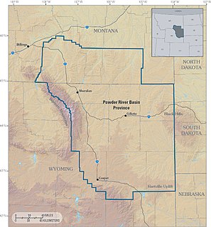
The Powder River Basin is a geologic structural basin in southeast Montana and northeast Wyoming, about 120 miles (190 km) east to west and 200 miles (320 km) north to south, known for its coal deposits. The region supplies about 40 percent of coal in the United States. It is both a topographic drainage and geologic structural basin. The basin is so named because it is drained by the Powder River, although it is also drained in part by the Cheyenne River, Tongue River, Bighorn River, Little Missouri River, Platte River, and their tributaries.
The Great Plains is the broad expanse of flat land, much of it covered in prairie, steppe, and grassland, that lies west of the Mississippi River tallgrass prairie in the United States and east of the Rocky Mountains in the U.S. and Canada. It embraces:
Wyoming is a state in the mountain region of the western United States. The state is the 10th largest by area, the least populous, and the second most sparsely populated state in the country. Wyoming is bordered on the north by Montana, on the east by South Dakota and Nebraska, on the south by Colorado, on the southwest by Utah, and on the west by Idaho and Montana. The state population was estimated at 577,737 in 2018, which is less than 31 of the most populous U.S. cities including Denver in neighboring Colorado. Cheyenne is the state capital and the most populous city, with an estimated population of 63,624 in 2017.
During the late 1860s, the area was the scene of Red Cloud's War, fought between the Lakota peoples and the United States. The Lakota victory in the war resulted in the continuation of their control of the area for the next decade.
Red Cloud's War was an armed conflict between the Lakota, Northern Cheyenne, and Northern Arapaho on one side and the United States in Wyoming and Montana territories from 1866 to 1868. The war was fought over control of the western Powder River Country in present north-central Wyoming. This grassland, rich in buffalo, was traditionally Crow Indian land, but the Lakota had recently taken control. The Crow tribe held the treaty right to the disputed area, according to the major agreement reached at Fort Laramie in 1851. All involved in "Red Cloud's War" were parties in that treaty.
The Lakota are a Native American tribe. Also known as the Teton Sioux, they are one of the three Sioux tribes of Plains. Their current lands are in North and South Dakota. They speak Lakȟótiyapi—the Lakota language, the westernmost of three closely related languages that belong to the Siouan language family.
After control of the area fell to the U.S. government in the 1870s following the end of the Great Sioux War of 1876–77, the area was opened to white settlement for homesteading. In 1892, the area was the scene of the Johnson County War.
The Johnson County War, also known as the War on Powder River and the Wyoming Range War, was a range conflict that took place in Johnson County, Wyoming from 1889 to 1893. The conflict began when cattle companies started ruthlessly persecuting alleged rustlers in the area, many of whom were innocent settlers that competed with them for land, livestock and water rights. As tensions swelled between the large established ranchers and the smaller settlers in the state, violence finally culminated in Powder River Country, when the ranchers hired armed gunmen to invade the county. The gunmen's initial incursion in the territory aroused the small farmers and ranchers, as well as the state lawmen, and they formed a posse of 200 men that led to a grueling stand-off. The siege ended when the United States Cavalry on the orders of President Benjamin Harrison relieved the two forces, although further fighting persisted in the following months.
In the early 20th century, the discovery of oil in the area led to the development of the area's oil fields. Coal is also mined.
Petroleum is a naturally occurring, yellowish-black liquid found in geological formations beneath the Earth's surface. It is commonly refined into various types of fuels. Components of petroleum are separated using a technique called fractional distillation, i.e. separation of a liquid mixture into fractions differing in boiling point by means of distillation, typically using a fractionating column.
Coal is a combustible black or brownish-black sedimentary rock, formed as rock strata called coal seams. Coal is mostly carbon with variable amounts of other elements; chiefly hydrogen, sulfur, oxygen, and nitrogen. Coal is formed if dead plant matter decays into peat and over millions of years the heat and pressure of deep burial converts the peat into coal. Vast deposits of coal originates in former wetlands—called coal forests—that covered much of the Earth's tropical land areas during the late Carboniferous (Pennsylvanian) and Permian times.
A geographic coordinate system is a coordinate system that enables every location on Earth to be specified by a set of numbers, letters or symbols. The coordinates are often chosen such that one of the numbers represents a vertical position and two or three of the numbers represent a horizontal position; alternatively, a geographic position may be expressed in a combined three-dimensional Cartesian vector. A common choice of coordinates is latitude, longitude and elevation. To specify a location on a plane requires a map projection.
This page is based on this Wikipedia article Text is available under the CC BY-SA 4.0 license; additional terms may apply. Images, videos and audio are available under their respective licenses.
Related Research Articles
The Arapaho are a tribe of Native Americans historically living on the plains of Colorado and Wyoming. They were close allies of the Cheyenne tribe and loosely aligned with the Lakota and Dakota.
The Sioux, are groups of Native American tribes and First Nations peoples in North America. The term can refer to any ethnic group within the Great Sioux Nation or to any of the nation's many language dialects. The modern Sioux consist of two major divisions based on language divisions: the Dakota and Lakota.
The Cheyenne are one of the indigenous people of the Great Plains and their language is of the Algonquian language family. The Cheyenne comprise two Native American tribes, the Só'taeo'o or Só'taétaneo'o and the Tsétsêhéstâhese. These tribes merged in the early 19th century. Today, the Cheyenne people are split into two federally recognized Nations: the Southern Cheyenne, who are enrolled in the Cheyenne and Arapaho Tribes in Oklahoma, and the Northern Cheyenne, who are enrolled in the Northern Cheyenne Tribe of the Northern Cheyenne Indian Reservation in Montana.
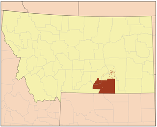
Broadus is a town in and the county seat of Powder River County, Montana, United States. The population was 468 at the 2010 census.
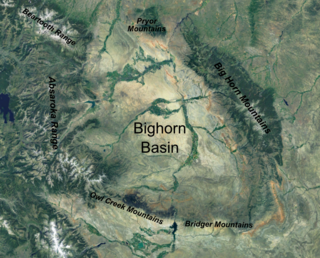
The Bighorn Basin is a plateau region and intermontane basin, approximately 100 miles (160 km) wide, in north-central Wyoming in the United States. It is bounded by the Absaroka Range on the west, the Bighorn Mountains on the east, and the Owl Creek Mountains and Bridger Mountains on the south. It is drained to the north by tributaries of the Bighorn River, which enters the basin from the south, through a gap between the Owl Creek and Bridger Mountains, as the Wind River, and becomes the Bighorn as it enters the basin. The region is semi-arid, receiving only 6–10 in (15–25 cm) of rain annually.
The Battle of the Rosebud occurred on June 17, 1876, in the Montana Territory between the United States Army and its Crow and Shoshoni allies against a force consisting mostly of Lakota Sioux and Northern Cheyenne Indians during the Great Sioux War of 1876. The Cheyenne called it the Battle Where the Girl Saved Her Brother because of an incident during the fight involving Buffalo Calf Road Woman. General George Crook's offensive was stymied by the Indians, led by Crazy Horse, and he awaited reinforcements before resuming the campaign in August.
The Pine Ridge is an escarpment between the Niobrara River and the White River in far northwestern Nebraska. The high tableland between the rivers has been eroded into a region of forested buttes, ridges and canyons.
The Horsemeat March of 1876, also known as the Mud March and the Starvation March, was a military expedition led by General George Crook in pursuit of a band of Sioux fleeing from anticipated retaliation for their massacre of George Armstrong Custer's 7th Cavalry Regiment at the Battle of the Little Bighorn. Poorly rationed and hampered by muddy conditions, the soldiers eventually had to butcher and eat their horses and mules as they became lame or injured. The Horsemeat March ended with the Battle of Slim Buttes and the capture and looting of American Horse the Elder's richly stocked village.
The Hunkpapa are a Native American group, one of the seven council fires of the Lakota tribe. The name Húŋkpapȟa is a Lakota word meaning "Head of the Circle". By tradition, the Húŋkpapȟa set up their lodges at the entryway to the circle of the Great Council when the Sioux met in convocation. They speak Lakȟóta, one of the three dialects of the Sioux language.
The Crow Indian Reservation is the homeland of the Crow Tribe of Indians of the State of Montana in the United States. The reservation is located in parts of Big Horn, Yellowstone, and Treasure counties in southern Montana. It has a land area of 3,593.56 sq mi (9,307.27 km²) and a total area of 3,606.54 sq mi (9,340.89 km²), making it either the fifth or sixth largest reservation in the country. Reservation headquarters are in Crow Agency.
The Battle of Powder River, also known as the Reynolds Battle, occurred on Friday, March 17, 1876, in Montana Territory, United States. The attack on a Cheyenne Indian encampment by Colonel Joseph J. Reynolds initiated the Great Sioux War of 1876. Although destroying a large amount of Indian property, the attack was poorly carried out and probably solidified Lakota Sioux and northern Cheyenne resistance to the U.S. attempt to force them to sell the Black Hills and live on a reservation.
Fort C. F. Smith was a military post established in the Powder River country by the United States Army in Montana Territory on August 12, 1866, during Red Cloud's War. Established by order of Col. Henry B. Carrington, it was one of five forts proposed to protect the Bozeman Trail against the Oglala Lakota (Sioux), who saw the trail as a violation of the 1851 Treaty of Fort Laramie. The fort was abandoned in 1868 and burned by the Sioux under Red Cloud.
The Hayfield Fight on August 1, 1867 was an engagement of Red Cloud's War near Fort C. F. Smith, Montana, between 21 soldiers of the U.S. Army, a hay-cutting crew of nine civilians, and several hundred Native Americans, mostly Cheyenne and Arapaho, with some Lakota Sioux. Armed with newly issued breechloading Springfield Model 1866 rifles, the heavily outnumbered soldiers held off the native warriors and inflicted casualties.
The Great Sioux War of 1876, also known as the Black Hills War, was a series of battles and negotiations which occurred in 1876 and 1877 between the Lakota Sioux, Northern Cheyenne, and the United States. The cause of the war was the desire of the U.S. government to obtain ownership of the Black Hills. Gold had been discovered in the Black Hills, settlers began to encroach onto Native American lands, and the Sioux and Cheyenne refused to cede ownership to the U.S. Traditionally, the United States military and historians place the Lakota at the center of the story, especially given their numbers, but some Indians believe the Cheyenne were the primary target of the U.S. campaign.
The Big Horn Expedition, or Bighorn Expedition, was a military operation of the United States Army against the Sioux, and Cheyenne Indians in Wyoming Territory and Montana Territory. Although soldiers destroyed one Cheyenne and Oglala Sioux village, the expedition solidified Lakota Sioux and northern Cheyenne resistance against the United States attempt to force them to sell the Black Hills and live on a reservation, beginning the Great Sioux War of 1876.
The Little Powder River is a tributary of the Powder River, in southeastern Montana and northeastern Wyoming in the United States. It drains an area historically known as the Powder River Country on the high plains east of the Bighorn Mountains.
The Big Muddy oil field is an oil field in Converse County, Wyoming, between Casper and Glenrock.