Johnson County, Wyoming

Last updated

Johnson County
Johnson County Courthouse Wyoming.jpg
Flag of Johnson County, Wyoming.gif
Map of Wyoming highlighting Johnson County.svg
Location within the U.S. state of Wyoming
Wyoming in United States.svg
Wyoming's location within the U.S.
Coordinates: 44°02′N106°35′W / 44.04°N 106.59°W / 44.04; -106.59
CountryFlag of the United States.svg United States
StateFlag of Wyoming.svg  Wyoming
FoundedDecember 8, 1875 (authorized)
1881 (organized)
Seat Buffalo
Largest cityBuffalo
Area
  Total4,175 sq mi (10,810 km2)
  Land4,154 sq mi (10,760 km2)
  Water20 sq mi (50 km2)  0.5%
Population
 (2020)
  Total8,447
  Density2.0/sq mi (0.78/km2)
Time zone UTC−7 (Mountain)
  Summer (DST) UTC−6 (MDT)
Congressional district At-large
Website johnsoncountywyoming.org

Johnson County is a county in the north central part of the U.S. state of Wyoming. At the 2020 United States Census, the population was 8,447. [1] The county seat is Buffalo. [2] Kaycee is the only other incorporated town in the county.

Contents

Johnson County lies to the southeast of the Bighorn Mountains along Interstate 25 and Interstate 90. The Powder River flows northward through eastern Johnson County.

History

Johnson County was created on December 8, 1875, as Pease County from parts of Albany, Carbon and Sweetwater Counties. It was organized in 1881. [3] The county was named for Dr. E. L. Pease of Uinta County. In 1879, the county was renamed Johnson, for E. P. Johnson, a Cheyenne attorney. [4]

In 1888, Sheridan County was created from a portion of Johnson County. In 1890, Big Horn County was created from Johnson County along with land from Fremont County and Sheridan County. In 1911, the boundaries of Johnson County and adjacent Crook, Natrona and Weston Counties were adjusted to run along federal land survey lines.

In April 1892, Johnson County was the scene of the Johnson County War, a range war between large cattle outfits and small stockgrowers.

Flag

Johnson County flag is based on the ikurriña; since the birth of Jean Esponda from Baigorri, there has been a large Basque population in the county. [5]

Geography

According to the US Census Bureau, the county has an area of 4,175 square miles (10,810 km2), of which 4,154 square miles (10,760 km2) is land and 20 square miles (52 km2) (0.5%) is water. [6]

Adjacent counties

Major highways

Transit

National protected area

Demographics

Historical population
CensusPop.Note
1880 637
1890 2,357270.0%
1900 2,3610.2%
1910 3,45346.3%
1920 4,61733.7%
1930 4,8164.3%
1940 4,9803.4%
1950 4,707−5.5%
1960 5,47516.3%
1970 5,5872.0%
1980 6,70019.9%
1990 6,145−8.3%
2000 7,07515.1%
2010 8,56921.1%
2020 8,447−1.4%
2023 (est.)8,759 [7] 3.7%
US Decennial Census [8]
1870–2000 [9] 2010–2016 [1]

2000 census

At the 2000 United States Census, [10] there were 7,075 people, 2,959 households and 2,006 families in the county. The population density was 2 people per square mile (0.77 people/km2). There were 3,503 housing units at an average density of 0.8 units per square mile (0.31 units/km2). The racial makeup of the county was 97.03% White, 0.08% Black or African American, 0.64% Native American, 0.11% Asian, 0.55% from other races, and 1.58% from two or more races. 2.09% of the population were Hispanic or Latino of any race. 27.0% were of German, 15.2% English, 10.8% Irish and 7.9% American ancestry.

There were 2,959 households, of which 28.70% had children under the age of 18 living with them, 57.00% were married couples living together, 7.10% had a female householder with no husband present, and 32.20% were non-families. 28.50% of all households were made up of individuals, and 12.00% had someone living alone who was 65 years of age or older. The average household size was 2.36 and the average family size was 2.89.

24.20% of the population were under the age of 18, 5.60% from 18 to 24, 23.50% from 25 to 44, 28.70% from 45 to 64, and 18.00% who were 65 years of age or older. The median age was 43 years. For every 100 females there were 96.60 males. For every 100 females age 18 and over, there were 94.30 males.

The median household income was $34,012 and the median family income was $42,299. Males had a median income of $29,271 and females $20,469. The per capita income was $19,030. About 7.20% of families and 10.10% of the population were below the poverty line, including 9.10% of those under age 18 and 10.60% of those age 65 or over.

2010 census

At the 2010 United States Census, there were 8,569 people, 3,782 households, and 2,410 families in the county. [11] The population density was 2.1 people per square mile (0.81 people/km2). There were 4,553 housing units at an average density of 1.1 units per square mile (0.42 units/km2). [12] The racial makeup was 96.5% white, 1.1% American Indian, 0.4% Asian, 0.2% black or African American, 0.7% from other races, and 1.1% from two or more races. Those of Hispanic or Latino origin made up 3.2% of the population. [11] In terms of ancestry, 31.6% were German, 22.4% were Irish, 18.3% were English, and 6.1% were American. [13]

Of the 3,782 households, 26.1% had children under the age of 18 living with them, 53.5% were married couples living together, 6.7% had a female householder with no husband present, 36.3% were non-families, and 31.8% of all households were made up of individuals. The average household size was 2.25 and the average family size was 2.83. The median age was 44.8 years. [11]

The median household income was $45,638 and the median family income was $58,983. Males had a median income of $40,572 and females $30,352. The per capita income was $26,753. About 5.9% of families and 8.2% of the population were below the poverty line, including 8.0% of those under age 18 and 7.3% of those age 65 or over. [14]

Communities

City

Town

Unincorporated communities

Government and infrastructure

Johnson County voters are reliably Republican. Since Wyoming statehood, the voters of this county have selected the Democratic Party candidate in only three national elections: William Jennings Bryan in 1896; Woodrow Wilson in 1912 by two votes and with only 37.5 percent of the total vote (due to Roosevelt's independent run that year); and Franklin D. Roosevelt by seventy votes in his 1932 landslide. FDR did not carry the county in his re-election campaigns; in 1936 Johnson was Alf Landon’s second-best county in the Western United States behind Rio Blanco County, Colorado. In the 1964 Democratic landslide it was Barry Goldwater's best county in Wyoming, and second-best in the West behind Utah's traditional banner Republican county of Kane.

United States presidential election results for Johnson County, Wyoming [17]
Year Republican Democratic Third party
No.%No.%No.%
2020 3,88178.98%89718.25%1362.77%
2016 3,47778.72%63814.44%3026.84%
2012 3,36378.96%74917.59%1473.45%
2008 3,33476.57%90820.85%1122.57%
2004 3,23180.96%67616.94%842.10%
2000 2,88681.30%55515.63%1093.07%
1996 2,07162.59%81524.63%42312.78%
1992 1,61451.30%65620.85%87627.84%
1988 2,08172.81%70724.74%702.45%
1984 2,63481.27%55817.22%491.51%
1980 2,29172.78%63520.17%2227.05%
1976 2,04271.25%79727.81%270.94%
1972 2,20383.13%43616.45%110.42%
1968 1,73773.85%39816.92%2179.23%
1964 1,64065.81%85234.19%00.00%
1960 1,80669.35%79830.65%00.00%
1956 1,84276.12%57823.88%00.00%
1952 1,98078.45%54321.51%10.04%
1948 1,35166.06%68233.35%120.59%
1944 1,38464.67%75635.33%00.00%
1940 1,46064.98%78134.76%60.27%
1936 1,26654.26%94940.68%1185.06%
1932 1,10147.05%1,17150.04%682.91%
1928 1,36969.25%59029.84%180.91%
1924 1,09758.01%50126.49%29315.49%
1920 1,20269.36%52530.29%60.35%
1916 81449.15%81249.03%301.81%
1912 52237.39%52437.54%35025.07%
1908 78155.39%61443.55%151.06%
1904 72560.82%45938.51%80.67%
1900 46651.43%44048.57%00.00%
1896 28437.72%46762.02%20.27%
1892 30934.30%00.00%59265.70%

The Wyoming Department of Health Veteran's Home of Wyoming, an assisted living facility for veterans and their dependents, is in Buffalo. [18] [19] The Wyoming Board of Charities and Reform operated the facility until the agency was dissolved as a result of a state constitutional amendment passed in November 1990. [20]

See also

Related Research Articles

<span class="mw-page-title-main">Weston County, Wyoming</span> County in Wyoming, United States

Weston County is a county in the U.S. state of Wyoming. As of the 2020 United States Census, the population was 6,838. Its county seat is Newcastle. Its east boundary line abuts the west line of the state of South Dakota.

<span class="mw-page-title-main">Washakie County, Wyoming</span> County in Wyoming, United States

Washakie County is a county in the U.S. state of Wyoming. As of the 2020 United States Census, the population was 7,685. Its county seat is Worland.

<span class="mw-page-title-main">Uinta County, Wyoming</span> County in Wyoming, United States

Uinta County is a county in the U.S. state of Wyoming. As of the 2020 United States Census, the population was 20,450. Its county seat is Evanston. Its south and west boundary lines abut the Utah state line.

<span class="mw-page-title-main">Sweetwater County, Wyoming</span> County in Wyoming, United States

Sweetwater County is a county in southwestern Wyoming, United States. As of the 2020 United States Census, the population was 42,272, making it the fourth-most populous county in Wyoming. Its county seat is Green River. By area, it is the largest county in Wyoming. Its southern boundary line abuts the north lines of the states of Colorado and Utah.

<span class="mw-page-title-main">Sheridan County, Wyoming</span> County in Wyoming, United States

Sheridan County is a county in the U.S. state of Wyoming. As of the 2020 United States Census, the population was 30,921. The county seat is Sheridan. Its northern boundary abuts the Montana state border.

<span class="mw-page-title-main">Platte County, Wyoming</span> County in Wyoming, United States

Platte County is a county located in the U.S. state of Wyoming. As of the 2020 United States Census, the population was 8,605. Its county seat is Wheatland.

<span class="mw-page-title-main">Park County, Wyoming</span> County in Wyoming, United States

Park County is a county in the U.S. state of Wyoming. As of the 2020 United States Census, the population was 29,624. The county seat is Cody.

<span class="mw-page-title-main">Niobrara County, Wyoming</span> County in the United States

Niobrara County is a county in the U.S. state of Wyoming. As of the 2020 United States Census, the population was 2,467, making it the least populous county in Wyoming. Its county seat is Lusk. Its eastern boundary abuts the west lines of the states of Nebraska and South Dakota.

<span class="mw-page-title-main">Natrona County, Wyoming</span> County in Wyoming, United States

Natrona County is a county in the U.S. state of Wyoming. As of the 2020 United States Census, the population was 79,955, making it the second-most populous county in Wyoming. Its county seat is Casper.

<span class="mw-page-title-main">Laramie County, Wyoming</span> County in Wyoming, United States

Laramie County is a county located at the southeast corner of the state of Wyoming. As of the 2020 United States Census, the population was 100,512 or 17.4% of the state's total 2020 population, making it the most populous county in Wyoming, but the least populous county in the United States to be the most populous in its state.

<span class="mw-page-title-main">Fremont County, Wyoming</span> County in Wyoming, United States

Fremont County is a county in the U.S. state of Wyoming. As of the 2020 United States census, the population was 39,234, making it the fifth-most populous county in Wyoming. Its county seat is Lander. The county was founded in 1884 and is named for John C. Frémont, a general, explorer, and politician. It is roughly the size of the state of Vermont.

<span class="mw-page-title-main">Converse County, Wyoming</span> County in Wyoming, United States

Converse County is a county located in the U.S. state of Wyoming. As of the 2020 United States Census, the population was 13,751. Its county seat is Douglas.

<span class="mw-page-title-main">Carbon County, Wyoming</span> County in Wyoming, United States

Carbon County is a county in the U.S. state of Wyoming. As of the 2020 United States Census, the population was 14,537. Its county seat is Rawlins. Its south border abuts the north line of Colorado.

<span class="mw-page-title-main">Campbell County, Wyoming</span> County in Wyoming, United States

Campbell County is a county in the U.S. state of Wyoming. As of the 2020 United States Census, the population was 47,026, making it the third-most populous county in Wyoming. Its county seat is Gillette.

<span class="mw-page-title-main">Big Horn County, Wyoming</span> County in Wyoming, United States

Big Horn County is a county in the U.S. state of Wyoming. As of the 2020 United States Census, the population was 11,521. The county seat is Basin. Its north boundary abuts the south boundary of Montana.

<span class="mw-page-title-main">Albany County, Wyoming</span> County in Wyoming, United States

Albany County is a county in the U.S. state of Wyoming. As of the 2020 United States Census, the population was 37,066. Its county seat is Laramie, the site of the University of Wyoming. Its south border lies on the northern Colorado state line.

<span class="mw-page-title-main">Lawrence County, South Dakota</span> County in South Dakota, United States

Lawrence County is a county in the U.S. state of South Dakota. As of the 2020 census, the population was 25,768, making it the 8th most populous county in South Dakota. Its county seat is Deadwood.

<span class="mw-page-title-main">Custer County, South Dakota</span> County in South Dakota, United States

Custer County is a county in the U.S. state of South Dakota. As of the 2020 census, the population was 8,318. Its county seat is Custer. The county was created in 1875, and was organized in 1877. It was named after General George Armstrong Custer.

<span class="mw-page-title-main">Buffalo County, Nebraska</span> County in Nebraska, United States

Buffalo County is a county located in the U.S. state of Nebraska in the Midwestern United States. As of the 2020 United States Census, the population was 50,084, making it Nebraska's fifth-most populous county. Its county seat is Kearney. The county was created in 1855 and was organized in 1870. It was named after the once-prevalent bison herds of the Great Plains.

<span class="mw-page-title-main">Buffalo, Wyoming</span> City in Wyoming, United States

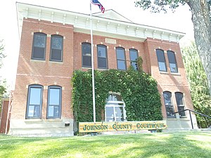
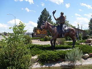
Buffalo is a city in Johnson County, Wyoming, United States. The city is located almost equidistant between Yellowstone Park and Mount Rushmore. The population was 4,415 at the 2020 census, down from 4,585 at the 2010 census. It is the county seat of Johnson County. The city has experienced an economic boom due to methane production from the Coal Bed Methane Extraction method used in the Powder River Basin and surrounding areas. However, with the decline of methane production, Buffalo's population has stabilized since the 2010 Census. Even though energy is a vital part of its economy, agriculture, tourism, and recreation are three other major components. Buffalo is located at the foot of the Bighorn Mountains.

References

  1. 1 2 "State & County QuickFacts". US Census Bureau. Archived from the original on June 6, 2011. Retrieved January 25, 2014.
  2. "Find a County". National Association of Counties. Archived from the original on May 31, 2011. Retrieved June 7, 2011.
  3. Long, John H., ed. (2004). "Wyoming: Individual County Chronologies". Wyoming Atlas of Historical County Boundaries. The Newberry Library. Archived from the original on August 3, 2015. Retrieved August 19, 2015.
  4. Urbanek, Mae (1988). Wyoming Place Names. Missoula MT: Mountain Press Pub. Co. ISBN   0-87842-204-8.
    - Gannett, Henry (1905). The Origin of Certain Place Names in the United States. Govt. Print. Off. p.  169.
  5. "The Flag | Basque Identity 2.0". August 4, 2012. Retrieved March 7, 2021.
  6. "2010 Census Gazetteer Files". US Census Bureau. August 22, 2012. Retrieved August 18, 2015.
  7. "Annual Estimates of the Resident Population for Counties: April 1, 2020 to July 1, 2023". United States Census Bureau. Retrieved March 24, 2024.
  8. "US Decennial Census". US Census Bureau. Retrieved August 18, 2015.
  9. "Historical Decennial Census Population for Wyoming Counties, Cities, and Towns". Wyoming Department of Administration & Information, Division of Economic Analysis. Retrieved January 25, 2014.
  10. "U.S. Census website". US Census Bureau. Retrieved May 14, 2011.
  11. 1 2 3 "Profile of General Population and Housing Characteristics: 2010 Demographic Profile Data". US Census Bureau. Archived from the original on February 13, 2020. Retrieved January 12, 2016.
  12. "Population, Housing Units, Area, and Density: 2010 - County". US Census Bureau. Archived from the original on February 13, 2020. Retrieved January 12, 2016.
  13. "Selected Social Characteristics in the US – 2006-2010 American Community Survey 5-Year Estimates". US Census Bureau. Archived from the original on February 13, 2020. Retrieved January 12, 2016.
  14. "Selected Economic Characteristics – 2006-2010 American Community Survey 5-Year Estimates". US Census Bureau. Archived from the original on February 13, 2020. Retrieved January 12, 2016.
  15. Hazelton WY Google Maps (accessed January 10, 2019)
  16. Sussex WY Google Maps (accessed January 10, 2019)
  17. Leip, David. "Atlas of US Presidential Elections". uselectionatlas.org. Retrieved April 5, 2018.
  18. Veterans' Home of Wyoming Archived May 13, 2009, at the Wayback Machine . Wyoming Department of Health. Retrieved December 12, 2010.
  19. Buffalo city, Wyoming [ permanent dead link ]. US Census Bureau. Retrieved December 12, 2010.
  20. "About the Department of Corrections", Wyoming Department of Corrections. Retrieved August 22, 2010.

44°02′N106°35′W / 44.04°N 106.59°W / 44.04; -106.59