Basin, Wyoming

Last updated

Basin, Wyoming
BasinWyoming.jpg
Downtown Basin, Wyoming
Flag of Basin, Wyoming.svg
Nickname: 
Lilac City
Big Horn County Wyoming Incorporated and Unincorporated areas Basin Highlighted 5605320.svg
Location of Basin in Big Horn County, Wyoming.
Usa edcp location map.svg
Red pog.svg
Basin, Wyoming
Location in the United States
Coordinates: 44°22′44″N108°2′35″W / 44.37889°N 108.04306°W / 44.37889; -108.04306
Country United States
State Wyoming
County Big Horn
Incorporated1902
Government
  TypeMayor-Council
  MayorCJ Duncan
Area
[1]
  Total2.39 sq mi (6.19 km2)
  Land2.36 sq mi (6.12 km2)
  Water0.03 sq mi (0.07 km2)
Elevation
3,878 ft (1,182 m)
Population
 (2010) [2]
  Total1,225
  Estimate 
(2019) [3]
1,282
  Density542.53/sq mi (209.47/km2)
Time zone UTC-7 (Mountain (MST))
  Summer (DST) UTC-6 (MDT)
ZIP code
82410
Area code 307
FIPS code 56-05320 [4]
GNIS feature ID1585173 [5]
Website www.thetownofbasin.com

Basin is a town in, and the county seat of, Big Horn County, Wyoming, United States. [6] The population was 1,225 at the 2020 census. The community is located near the center of the Bighorn Basin with the Big Horn River east of the town. Basin's post office, built in 1919, is listed on the National Register of Historic Places.

Contents

Geography

Basin is located at 44°22′44″N108°2′35″W / 44.37889°N 108.04306°W / 44.37889; -108.04306 (44.378777, -108.043100). [7]

According to the United States Census Bureau, the town has a total area of 2.43 square miles (6.29 km2), of which 2.40 square miles (6.22 km2) is land and 0.03 square miles (0.08 km2) is water. [8]

Basin is known as The Lilac City and hosts the Big Horn County Fair each summer.

Climate

Basin has a cold desert climate (Köppen climate classification BWk ). The town had the highest temperature ever recorded in Wyoming, 115 °F (46 °C), on August 8, 1983, [9] and also holds the state record high temperatures for April (93 °F or 33.9 °C in 1948) and July (114 °F or 45.6 °C in 1900). [10]

In general, the eastern portion of the Bighorn Basin is hotter than the rest of Wyoming during the summer months. [11] Due to frequent low humidity, daily temperature ranges are large, whilst due to the very dry conditions snowfall is among the lightest in the northern Rockies and Plains region – it is not uncommon for no measurable precipitation to fall in a month between September and April. There are an average of 49.4 days annually with highs of 90 °F (32 °C) or higher, 5.4 days greater than 100 °F (38 °C) and an average of 176.2 nights with lows of 32 °F (0 °C) or lower. The all-time record low for Basin was −51 °F (−46 °C) on February 5, 1899. The wettest calendar year in Basin was 2011 with 10.84 inches (275 mm) and the driest 1902 with 2.63 inches (67 mm). The most precipitation in one month was 4.56 inches (116 mm) in June 1967. The most precipitation in 24 hours was 2.23 inches (57 mm) on June 29, 1909. The most snowfall in one season was 38.50 inches (0.978 m) between July 1958 and June 1959, whilst the most snow in one month was 23.0 inches (0.58 m) during September 1984. [12]

Climate data for Basin 1991–2020 normals, extremes 1898–present
MonthJanFebMarAprMayJunJulAugSepOctNovDecYear
Record high °F (°C)64
(18)
73
(23)
82
(28)
90
(32)
99
(37)
110
(43)
112
(44)
115
(46)
102
(39)
91
(33)
77
(25)
67
(19)
115
(46)
Mean maximum °F (°C)47.9
(8.8)
55.1
(12.8)
72.3
(22.4)
81.9
(27.7)
89.0
(31.7)
97.4
(36.3)
101.9
(38.8)
99.8
(37.7)
94.7
(34.8)
82.9
(28.3)
64.2
(17.9)
51.3
(10.7)
102.4
(39.1)
Mean daily maximum °F (°C)32.4
(0.2)
39.1
(3.9)
54.1
(12.3)
63.0
(17.2)
72.8
(22.7)
83.7
(28.7)
92.7
(33.7)
91.0
(32.8)
79.3
(26.3)
62.9
(17.2)
46.4
(8.0)
33.8
(1.0)
62.6
(17.0)
Daily mean °F (°C)20.6
(−6.3)
26.8
(−2.9)
40.7
(4.8)
49.8
(9.9)
59.8
(15.4)
69.2
(20.7)
76.5
(24.7)
74.1
(23.4)
63.4
(17.4)
49.2
(9.6)
34.6
(1.4)
22.6
(−5.2)
48.9
(9.4)
Mean daily minimum °F (°C)8.8
(−12.9)
14.6
(−9.7)
27.4
(−2.6)
36.5
(2.5)
46.8
(8.2)
54.7
(12.6)
60.3
(15.7)
57.2
(14.0)
47.5
(8.6)
35.5
(1.9)
22.8
(−5.1)
11.4
(−11.4)
35.3
(1.8)
Mean minimum °F (°C)−16.3
(−26.8)
−10.3
(−23.5)
5.1
(−14.9)
19.2
(−7.1)
28.8
(−1.8)
40.4
(4.7)
48.6
(9.2)
43.9
(6.6)
32.0
(0.0)
17.1
(−8.3)
−0.6
(−18.1)
−9.7
(−23.2)
−22.3
(−30.2)
Record low °F (°C)−43
(−42)
−51
(−46)
−31
(−35)
−4
(−20)
18
(−8)
30
(−1)
36
(2)
34
(1)
14
(−10)
−7
(−22)
−28
(−33)
−43
(−42)
−51
(−46)
Average precipitation inches (mm)0.24
(6.1)
0.32
(8.1)
0.31
(7.9)
0.75
(19)
1.37
(35)
1.04
(26)
0.41
(10)
0.32
(8.1)
0.95
(24)
0.79
(20)
0.36
(9.1)
0.30
(7.6)
7.16
(180.9)
Average snowfall inches (cm)3.4
(8.6)
4.1
(10)
2.3
(5.8)
1.5
(3.8)
0.1
(0.25)
0.0
(0.0)
0.0
(0.0)
0.0
(0.0)
0.2
(0.51)
1.5
(3.8)
3.0
(7.6)
4.0
(10)
20.1
(50.36)
Average precipitation days (≥ 0.01 in)3.43.63.15.17.16.03.23.64.74.03.33.350.4
Average snowy days (≥ 0.1 in)2.52.61.40.70.10.00.00.00.10.71.72.312.1
Source: NOAA [13] [14]

Demographics

Historical population
CensusPop.Note
1910 763
1920 1,08842.6%
1930 903−17.0%
1940 1,09921.7%
1950 1,22011.0%
1960 1,3198.1%
1970 1,145−13.2%
1980 1,34917.8%
1990 1,180−12.5%
2000 1,2384.9%
2010 1,2853.8%
2020 1,225−4.7%
U.S. Decennial Census [15]
Flooding of Greybull River near Basin, Wyoming in June 1963, where the peak flow was 19,400 cubic feet per second (550 m/s). GreybullRiver1963.jpg
Flooding of Greybull River near Basin, Wyoming in June 1963, where the peak flow was 19,400 cubic feet per second (550 m/s).

2010 census

As of the census [2] of 2010, there were 1,285 people, 520 households, and 333 families residing in the town. The population density was 535.4 inhabitants per square mile (206.7/km2). There were 571 housing units at an average density of 237.9 per square mile (91.9/km2). The racial makeup of the town was 94.2% White, 0.5% African American, 1.9% Native American, 0.5% Asian, 1.6% from other races, and 1.3% from two or more races. Hispanic or Latino of any race were 5.4% of the population.

There were 520 households, of which 25.0% had children under the age of 18 living with them, 51.9% were married couples living together, 8.3% had a female householder with no husband present, 3.8% had a male householder with no wife present, and 36.0% were non-families. 31.5% of all households were made up of individuals, and 15.8% had someone living alone who was 65 years of age or older. The average household size was 2.27 and the average family size was 2.83.

The median age in the town was 46.4 years. 20.1% of residents were under the age of 18; 6.7% were between the ages of 18 and 24; 21.5% were from 25 to 44; 27.2% were from 45 to 64; and 24.4% were 65 years of age or older. The gender makeup of the town was 50.0% male and 50.0% female.

2000 census

As of the census [4] of 2000, there were 1,238 people, 504 households, and 330 families residing in the town. The population density was 613.7 people per square mile (236.6/km2). There were 565 housing units at an average density of 280.1 per square mile (108.0/km2). The racial makeup of the town was 96.77% White, 0.08% African American, 1.05% Native American, 0.24% Asian, 0.97% from other races, and 0.89% from two or more races. Hispanic or Latino of any race were 2.26% of the population.

There were 504 households, out of which 22.2% had children under the age of 18 living with them, 56.3% were married couples living together, 6.3% had a female householder with no husband present, and 34.5% were non-families. 31.3% of all households were made up of individuals, and 16.5% had someone living alone who was 65 years of age or older. The average household size was 2.20 and the average family size was 2.74.

In the town, the population was spread out, with 20.1% under the age of 18, 5.5% from 18 to 24, 19.6% from 25 to 44, 27.9% from 45 to 64, and 26.9% who were 65 years of age or older. The median age was 48 years. For every 100 females, there were 90.8 males. For every 100 females age 18 and over, there were 86.6 males.

The median income for a household in the town was $33,519, and the median income for a family was $42,768. Males had a median income of $33,942 versus $20,139 for females. The per capita income for the town was $17,890. About 6.1% of families and 11.6% of the population were below the poverty line, including 17.5% of those under age 18 and 12.7% of those age 65 or over.

Government and infrastructure

The Wyoming Department of Health Wyoming Retirement Center, a nursing home, [16] is located in Basin. [17] [18] The facility was operated by the Wyoming Board of Charities and Reform until that agency was dissolved as a result of a state constitutional amendment passed in November 1990. [19]

The United States Postal Service operates the Basin Post Office. [20]

Education

Public education in the town of Basin is provided by Big Horn County School District #4. The district has 3 schools across a single campus – Laura Irwin Elementary School (grades K-5), Riverside Middle School (grades 6–8), and Riverside High School (grades 9–12). The middle school and high school both operate under one building, which is adjacent to the elementary school building. [21]

Basin has a public library, a branch of the Big Horn County Library System. [22]

Transportation

Intercity bus service to the city is provided by Express Arrow. [23]

See also

Related Research Articles

<span class="mw-page-title-main">Johnson County, Wyoming</span> County in Wyoming, United States

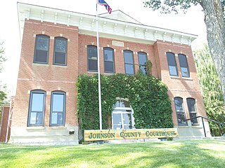
Johnson County is a county in the north central part of the U.S. state of Wyoming. At the 2020 United States Census, the population was 8,447. The county seat is Buffalo. Kaycee is the only other incorporated town in the county.

<span class="mw-page-title-main">Washakie County, Wyoming</span> County in Wyoming, United States

Washakie County is a county in the U.S. state of Wyoming. As of the 2020 United States Census, the population was 7,685. Its county seat is Worland.

<span class="mw-page-title-main">Sheridan County, Wyoming</span> County in Wyoming, United States

Sheridan County is a county in the U.S. state of Wyoming. As of the 2020 United States Census, the population was 30,921. The county seat is Sheridan. Its northern boundary abuts the Montana state border.

<span class="mw-page-title-main">Park County, Wyoming</span> County in Wyoming, United States

Park County is a county in the U.S. state of Wyoming. As of the 2020 United States Census, the population was 29,624. The county seat is Cody.

<span class="mw-page-title-main">Hot Springs County, Wyoming</span> County in Wyoming, United States

Hot Springs County is a county in the U.S. state of Wyoming. As of the 2020 United States Census, the population was 4,696, making it the second-least populous county in Wyoming. Its county seat is Thermopolis. The county is named for the hot springs located in Hot Springs State Park.

<span class="mw-page-title-main">Fremont County, Wyoming</span> County in Wyoming, United States

Fremont County is a county in the U.S. state of Wyoming. As of the 2020 United States census, the population was 39,234, making it the fifth-most populous county in Wyoming. Its county seat is Lander. The county was founded in 1884 and is named for John C. Frémont, a general, explorer, and politician. It is roughly the size of the state of Vermont.

<span class="mw-page-title-main">Big Horn County, Wyoming</span> County in Wyoming, United States

Big Horn County is a county in the U.S. state of Wyoming. As of the 2020 United States Census, the population was 11,521. The county seat is Basin. Its north boundary abuts the south boundary of Montana.

<span class="mw-page-title-main">Big Horn County, Montana</span> County in Montana, United States

Big Horn County is a county located in the U.S. state of Montana. As of the 2020 census, the population was 13,124. The county seat is Hardin. The county, like the river and the mountain range, is named after the bighorn sheep in the Rocky Mountains. The county was founded in 1913. It is located on the south line of the state.

<span class="mw-page-title-main">Cowley, Wyoming</span> Town in Wyoming, United States

Cowley is a town in Big Horn County, Wyoming, United States. The population was 762 at the 2020 census.

<span class="mw-page-title-main">Deaver, Wyoming</span> Town in Wyoming, United States

Deaver is a town in Big Horn County, Wyoming, United States. The population was 178 at the 2010 census.

<span class="mw-page-title-main">Greybull, Wyoming</span> Town in Wyoming, United States

Greybull is a town in central Big Horn County, Wyoming, United States. The population was 1,669 at the 2020 census.

<span class="mw-page-title-main">Lovell, Wyoming</span> Town in Wyoming, United States

Lovell is the largest town in Big Horn County, Wyoming, United States. The population was 2,243 at the 2020 census.

<span class="mw-page-title-main">Dubois, Wyoming</span> Town in Wyoming, United States

Dubois is a town in Fremont County, Wyoming, United States. The population was 971 at the 2010 census, but dropped to 911 in the 2020 census. The population nearly doubles in the summer with many part-time residents.

<span class="mw-page-title-main">Thermopolis, Wyoming</span> Town in Wyoming, United States

Thermopolis is the county seat and most populous town in Hot Springs County, Wyoming, United States. As of the 2020 U.S. Census, the town population was 2,725.

<span class="mw-page-title-main">Buffalo, Wyoming</span> City in Wyoming, United States

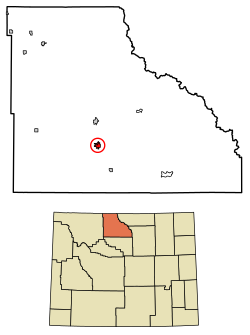
Buffalo is a city in Johnson County, Wyoming, United States. The city is located almost equidistant between Yellowstone Park and Mount Rushmore. The population was 4,415 at the 2020 census, down from 4,585 at the 2010 census. It is the county seat of Johnson County. The city has experienced an economic boom due to methane production from the Coal Bed Methane Extraction method used in the Powder River Basin and surrounding areas. However, with the decline of methane production, Buffalo's population has stabilized since the 2010 Census. Even though energy is a vital part of its economy, agriculture, tourism, and recreation are three other major components. Buffalo is located at the foot of the Bighorn Mountains.

<span class="mw-page-title-main">Cody, Wyoming</span> City in Wyoming, United States

Cody is a city in and the county seat of Park County, Wyoming, United States. It is named after Buffalo Bill Cody for his part in the founding of Cody in 1896.

<span class="mw-page-title-main">Powell, Wyoming</span> City in Park County, Wyoming, United States

Powell is a city in Park County, Wyoming, United States. The population was 6,314 at the 2010 census. Powell is an All-America City and home to Northwest College.

<span class="mw-page-title-main">Ten Sleep, Wyoming</span> Town in Wyoming, United States

Ten Sleep is a town in Washakie County, Wyoming, United States. It is located in the Bighorn Basin in the western foothills of the Bighorn Mountains, approximately 26 miles (42 km) east of Worland and 59 miles (95 km) west of Buffalo.

<span class="mw-page-title-main">Worland, Wyoming</span> City in Wyoming, United States

Worland is a city in Washakie County, Wyoming, United States. The population was 5,487 at the 2010 census. It is the county seat of Washakie County. It is located within the Big Horn Basin and along the Big Horn River in northwestern Wyoming.

<span class="mw-page-title-main">Frannie, Wyoming</span> Town in Wyoming, United States

Frannie is a town in Big Horn and Park counties in the U.S. state of Wyoming. The population was 157 at the 2010 census.

References

  1. "2019 U.S. Gazetteer Files". United States Census Bureau. Retrieved August 7, 2020.
  2. 1 2 "U.S. Census website". United States Census Bureau . Retrieved December 14, 2012.
  3. "Population and Housing Unit Estimates". United States Census Bureau. May 24, 2020. Retrieved May 27, 2020.
  4. 1 2 "U.S. Census website". United States Census Bureau . Retrieved January 31, 2008.
  5. "US Board on Geographic Names". United States Geological Survey. October 25, 2007. Retrieved January 31, 2008.
  6. "Find a County". National Association of Counties. Archived from the original on July 12, 2012. Retrieved June 7, 2011.
  7. "US Gazetteer files: 2010, 2000, and 1990". United States Census Bureau. February 12, 2011. Retrieved April 23, 2011.
  8. "US Gazetteer files 2010". United States Census Bureau. Archived from the original on January 25, 2012. Retrieved December 14, 2012.
  9. "Record Highest Temperatures by State". www.infoplease.com. Retrieved March 24, 2021.
  10. "Wyoming: Temperature Extremes". www.infoplease.com. Retrieved March 24, 2021.
  11. "Wyoming Climate". University of Wyoming. Archived from the original on September 5, 2009.
  12. "BASIN, WYOMING - Climate Summary". www.wrcc.dri.edu. Retrieved March 24, 2021.
  13. "NOWData - NOAA Online Weather Data". National Oceanic and Atmospheric Administration.
  14. "Summary of Monthly Normals 19912020". National Oceanic and Atmospheric Administration . Retrieved October 19, 2021.
  15. "Census of Population and Housing". Census.gov. Retrieved June 4, 2015.
  16. "WDH Who We Are - Wyoming Retirement Center Archived 2007-06-27 at the Wayback Machine ." Wyoming Department of Health. Retrieved on December 12, 2010.
  17. "WDH Directory [ permanent dead link ]." Wyoming Department of Health. Retrieved on December 12, 2010. "890 Highway 20, Basin WY 82410 Fax (307) 568-3887" (Retirement Center)
  18. "Basin town, Wyoming [ permanent dead link ]." U.S. Census Bureau. Retrieved on December 12, 2010.
  19. "About the Department of Corrections." Wyoming Department of Corrections. Retrieved on August 22, 2010.
  20. "Post Office Location - BASIN Archived August 20, 2010, at the Wayback Machine ." United States Postal Service. Retrieved on December 12, 2010.
  21. "Bighorn County School District #4". BGH4. Retrieved March 6, 2023.
  22. "Wyoming Public Libraries". PublicLibraries.com. Retrieved June 13, 2019.
  23. "Express Arrow Locations" . Retrieved July 20, 2023.