Sturgis, South Dakota

Last updated

Sturgis
Sturgis, South Dakota
Sturgis, South Dakota (2014).jpg
View over Sturgis in early 2014
Meade County South Dakota Incorporated and Unincorporated areas Sturgis Highlighted.svg
Location in Meade County and the state of South Dakota
Usa edcp location map.svg
Red pog.svg
Sturgis
Location in the United States
Coordinates: 44°24′41″N103°30′01″W / 44.41139°N 103.50028°W / 44.41139; -103.50028
Country United States
State South Dakota
County Meade
Founded1878
Incorporated1888 [1]
Government
   Mayor Mark Carstensen
Area
[2]
  Total6.51 sq mi (16.86 km2)
  Land6.42 sq mi (16.63 km2)
  Water0.09 sq mi (0.24 km2)
Elevation
[3]
3,458 ft (1,054 m)
Population
 (2020) [4]
  Total7,020
  Density1,093.46/sq mi (422.17/km2)
Time zone UTC−7 (Mountain (MST))
  Summer (DST) UTC−6 (MDT)
ZIP Code
57785
Area code 605
FIPS code 46-62100 [5]
GNIS feature ID1267596 [3]
Website City of Sturgis

Sturgis is a city in Meade County, South Dakota, United States. The population was 7,020 as of the 2020 census. [6] It is the county seat of Meade County [7] and is named after Samuel D. Sturgis, a Union general during the Civil War.

Contents

Sturgis is notable as the location of one of the largest annual motorcycle events in the world: the Sturgis Motorcycle Rally, which lasts for 10 days beginning on the first Friday of August. It attracts large numbers of motorcycle enthusiasts from around the world. Sturgis is also noted for hosting WCW's Hog Wild/Road Wild events from 1996 to 1999.

History

Sturgis was founded in 1878. [8] An early nickname for the town was "Scooptown." Scooptown had been an earlier settlement at the base of Bear Butte, that supplied the soldiers at Camp Sturgis an outlet for their vices. When it became apparent that Sturgis was going to be the city that supplied the newly formed Fort Meade, the occupants of Scooptown moved en masse to Sturgis and set up their shops. [9] Sturgis was named in honor of the Civil War Union General Samuel D. Sturgis. [10] In 1889, Sturgis was designated as the county seat of the newly formed Meade County. [8]

As part of the vast Ellsworth Air Force Base complex, the land north of Sturgis was dotted with 50 Minuteman missile silos. Minuteman missile silo L-5 is located 3.5 miles (5.6 km) from the center of the town.

Towards the end of the summer of 2015, the Full Throttle Saloon, described as the world's largest biker bar [11] and the subject of the reality television series Full Throttle Saloon , burned down, [12] but was rebuilt on 600 acres in nearby Vale near Bear Butte. [13]

Geography

According to the United States Census Bureau, the city has a total area of 3.99 square miles (10.33 km2), all land. [14]

Climate

Sturgis has a hot-summer humid continental climate (Dfa.) The hardiness zone is 5a.

Climate data for Sturgis, South Dakota (Fort Meade) 1991–2020 normals, extremes 1902–present
MonthJanFebMarAprMayJunJulAugSepOctNovDecYear
Record high °F (°C)72
(22)
75
(24)
85
(29)
92
(33)
100
(38)
106
(41)
109
(43)
107
(42)
104
(40)
93
(34)
83
(28)
74
(23)
109
(43)
Mean maximum °F (°C)62.0
(16.7)
62.9
(17.2)
72.2
(22.3)
79.4
(26.3)
85.4
(29.7)
93.1
(33.9)
98.0
(36.7)
97.5
(36.4)
94.0
(34.4)
83.7
(28.7)
69.7
(20.9)
61.5
(16.4)
100.3
(37.9)
Average high °F (°C)37.7
(3.2)
39.2
(4.0)
48.7
(9.3)
57.8
(14.3)
67.0
(19.4)
78.2
(25.7)
86.4
(30.2)
85.6
(29.8)
77.0
(25.0)
60.7
(15.9)
47.8
(8.8)
39.1
(3.9)
60.4
(15.8)
Daily mean °F (°C)26.4
(−3.1)
27.8
(−2.3)
36.6
(2.6)
45.6
(7.6)
55.3
(12.9)
65.7
(18.7)
73.2
(22.9)
71.8
(22.1)
62.8
(17.1)
48.5
(9.2)
36.4
(2.4)
28.2
(−2.1)
48.2
(9.0)
Average low °F (°C)15.1
(−9.4)
16.5
(−8.6)
24.6
(−4.1)
33.5
(0.8)
43.7
(6.5)
53.2
(11.8)
59.9
(15.5)
57.9
(14.4)
48.6
(9.2)
36.4
(2.4)
25.0
(−3.9)
17.2
(−8.2)
36.0
(2.2)
Mean minimum °F (°C)−9.1
(−22.8)
−5.7
(−20.9)
2.5
(−16.4)
16.1
(−8.8)
29.3
(−1.5)
41.6
(5.3)
48.8
(9.3)
46.5
(8.1)
33.4
(0.8)
17.5
(−8.1)
4.2
(−15.4)
−5.6
(−20.9)
−15.4
(−26.3)
Record low °F (°C)−35
(−37)
−31
(−35)
−20
(−29)
0
(−18)
15
(−9)
27
(−3)
29
(−2)
35
(2)
20
(−7)
−5
(−21)
−20
(−29)
−30
(−34)
−35
(−37)
Average precipitation inches (mm)0.49
(12)
0.72
(18)
1.25
(32)
2.45
(62)
4.44
(113)
3.30
(84)
2.27
(58)
1.72
(44)
1.40
(36)
1.90
(48)
0.84
(21)
0.50
(13)
21.28
(541)
Average snowfall inches (cm)5.3
(13)
8.3
(21)
8.4
(21)
7.9
(20)
1.4
(3.6)
0.0
(0.0)
0.0
(0.0)
0.0
(0.0)
0.0
(0.0)
2.8
(7.1)
5.3
(13)
8.2
(21)
47.6
(121)
Average precipitation days (≥ 0.01 in)6.06.67.09.412.211.89.37.16.27.75.85.394.4
Average snowy days (≥ 0.1 in)3.33.62.11.50.30.00.00.00.00.91.72.916.3
Source: NOAA [15] [16]

Demographics

Historical population
CensusPop.Note
1880 60
1890 6681,013.3%
1900 1,10064.7%
1910 1,73958.1%
1920 1,250−28.1%
1930 1,74739.8%
1940 3,00872.2%
1950 3,47115.4%
1960 4,63933.7%
1970 4,536−2.2%
1980 5,18414.3%
1990 5,3302.8%
2000 6,44220.9%
2010 6,6272.9%
2020 7,0205.9%
U.S. Decennial Census [17]
2017 Estimate [18] [4]

2010 census

As of the census [19] of 2010, there were 6,627 people, 2,916 households, and 1,687 families living in the city. The population density was 1,660.9 inhabitants per square mile (641.3/km2). There were 3,154 housing units at an average density of 790.5 per square mile (305.2/km2). The racial makeup of the city was 93.9% White, 0.2% African American, 2.3% Native American, 0.4% Asian, 0.6% from other races, and 2.6% from two or more races. Hispanic or Latino of any race were 2.6% of the population.

There were 2,916 households, of which 28.8% had children under the age of 18 living with them, 41.3% were married couples living together, 12.2% had a female householder with no husband present, 4.4% had a male householder with no wife present, and 42.1% were non-families. 37.0% of all households were made up of individuals, and 17.2% had someone living alone who was 65 years of age or older. The average household size was 2.21 and the average family size was 2.89.

The median age in the city was 41.2 years. 23.9% of residents were under the age of 18; 7.8% were between the ages of 18 and 24; 22.3% were from 25 to 44; 27.1% were from 45 to 64; and 18.8% were 65 years of age or older. The gender makeup of the city was 48.1% male and 51.9% female.

2000 census

As of the census [5] of 2000, there were 6,442 people, 2,738 households, and 1,708 families living in the city. The population density was 1,723.6 inhabitants per square mile (665.5/km2). There were 2,989 housing units at an average density of 799.7 per square mile (308.8/km2). The racial makeup of the city was 94.80% White, 0.20% African American, 2.48% Native American, 0.31% Asian, 0.33% from other races, and 1.88% from two or more races. Hispanic or Latino of any race were 1.75% of the population.

There were 2,738 households, out of which 30.2% had children under the age of 18 living with them, 48.0% were married couples living together, 11.5% had a female householder with no husband present, and 37.6% were non-families. 33.3% of all households were made up of individuals, and 15.6% had someone living alone who was 65 years of age or older. The average household size was 2.29 and the average family size was 2.91.

In the city, the population was spread out, with 25.0% under the age of 18, 7.9% from 18 to 24, 25.4% from 25 to 44, 22.5% from 45 to 64, and 19.3% who were 65 years of age or older. The median age was 40 years. For every 100 females, there were 91.0 males. For every 100 females age 18 and over, there were 86.1 males.

As of 2000 the median income for a household in the city was $30,253, and the median income for a family was $38,698. Males had a median income of $25,856 versus $18,582 for females. The per capita income for the city was $16,763. About 11.0% of families and 12.0% of the population were below the poverty line, including 12.7% of those under age 18 and 6.8% of those age 65 or over.

Arts and culture

Ox teams in Sturgis, circa 1887 to 1892 Grabill - Ox teams at Sturgis.jpg
Ox teams in Sturgis, circa 1887 to 1892
Motorbikes on Main Street during Bike Week Main Street Sturgis South Dakota Bike Week.jpg
Motorbikes on Main Street during Bike Week

Public sculptures

Media

Radio stations

Notable people

Related Research Articles

<span class="mw-page-title-main">Meade County, South Dakota</span> County in South Dakota, United States

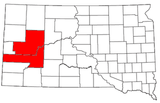
Meade County is a county in the U.S. state of South Dakota. As of the 2020 census, the population was 29,852. Its county seat is Sturgis. The county was created in 1889 and named for Fort Meade, which was garrisoned as a United States military post in the area in 1878 and itself named for General George Meade.

<span class="mw-page-title-main">Haakon County, South Dakota</span> County in South Dakota, United States

Haakon County is a county in the U.S. state of South Dakota. As of the 2020 census, the population was 1,872. Its county seat is Philip.

<span class="mw-page-title-main">Sturgis, Mississippi</span> Town in Mississippi, United States

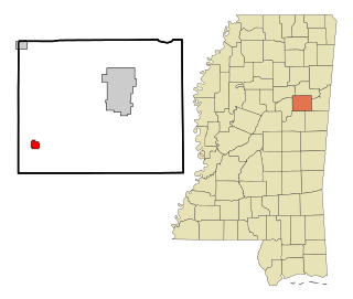
Sturgis is a town in Oktibbeha County, Mississippi. The population was 207 at the 2020 census.

<span class="mw-page-title-main">Alice, North Dakota</span> City in North Dakota, United States

Alice is a city in Cass County, North Dakota, United States. The population was 41 at the 2020 census.

<span class="mw-page-title-main">Cavalier, North Dakota</span> City in North Dakota, United States

Cavalier is the largest city in Pembina County, North Dakota, United States. It is the county seat of Pembina County. The population was 1,246 at the 2020 census. Cavalier was founded in 1875 and became the county seat in 1911.

<span class="mw-page-title-main">Stickney, South Dakota</span> Town in South Dakota, United States

Stickney is a town in Aurora County, South Dakota, United States. The population was 321 at the 2020 census.

<span class="mw-page-title-main">Mound City, South Dakota</span> Town in South Dakota, United States

Mound City is a town in and the county seat of Campbell County, South Dakota, United States. The population was 69 at the 2020 census.

<span class="mw-page-title-main">Custer, South Dakota</span> City in South Dakota, United States

Custer is a city in Custer County, South Dakota, United States. The population was 1,919 at the 2020 census. It is the county seat of Custer County.

<span class="mw-page-title-main">Clear Lake, South Dakota</span> City in South Dakota, United States

Clear Lake is a city in and the county seat of Deuel County, South Dakota, United States. The population was 1,218 at the 2020 census.

<span class="mw-page-title-main">Miller, South Dakota</span> City in South Dakota, United States

Miller is a city in and county seat of Hand County, South Dakota, United States. The population was 1,349 at the 2020 census.

<span class="mw-page-title-main">Parkston, South Dakota</span> City in South Dakota, United States

Parkston is a city in Hutchinson County, South Dakota, United States. The population was 1,567 at the 2020 census.

<span class="mw-page-title-main">Central City, South Dakota</span> City in South Dakota, United States

Central City is a city in Lawrence County, South Dakota, United States. The population was 93 at the 2020 census.

<span class="mw-page-title-main">Blackhawk, South Dakota</span> CDP in South Dakota, United States

Black Hawk is an unincorporated census-designated place (CDP) in Meade County, South Dakota, United States. The population was 3,026 at the 2020 census. Black Hawk has been assigned the ZIP code of 57718. Located along Interstate 90, Black Hawk is part of the Rapid City metropolitan area.

<span class="mw-page-title-main">Faith, South Dakota</span> City in South Dakota, United States

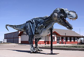
Faith is a city in the northeastern corner of Meade County, South Dakota, United States. The population was 367 at the 2020 census. The most complete Tyrannosaurus rex skeleton known, Sue, was discovered approximately 15 miles (24 km) northeast of Faith in August 1990.

<span class="mw-page-title-main">Baltic, South Dakota</span> City in South Dakota, United States

Baltic is a city on the Big Sioux River in northern Minnehaha County, South Dakota, United States. The population was 1,246 at the 2020 census.

<span class="mw-page-title-main">Crooks, South Dakota</span> City in South Dakota, United States

Crooks is a city in Minnehaha County, South Dakota, United States and is a suburb of Sioux Falls. The population was 1,362 at the 2020 census. Crooks was named New Hope until 1904. The town's present name honors W. A. Crooks, a local politician.

<span class="mw-page-title-main">Hartford, South Dakota</span> City in South Dakota, United States

Hartford is a suburban American city in Minnehaha County, South Dakota, a few miles northwest of Sioux Falls. Its population was 3,354 at the 2020 census.

<span class="mw-page-title-main">Mission, South Dakota</span> City in South Dakota, United States

Mission is a city on the Rosebud Indian Reservation in northern Todd County, South Dakota, United States. The population was 1,156 at the 2020 census.

Piedmont is a city in Meade County, South Dakota, United States. According to the 2020 census, its population was 971. Piedmont lies along Interstate 90 between Rapid City and Sturgis. Piedmont has been assigned the ZIP Code of 57769.

<span class="mw-page-title-main">Rapid City, South Dakota metropolitan area</span>

The Rapid City-Spearfish, SD combined statistical area, as defined by the United States Census Bureau, consists of the Rapid City, SD metropolitan statistical area and Spearfish, SD micropolitan statistical area. Anchored by the city of Rapid City, the area corresponds to the entirety of Pennington, Meade, and Lawrence counties in the state of South Dakota. As of the 2020 census, the CSA had a population of 164,842.

References

  1. "SD Towns" (PDF). South Dakota State Historical Society . Retrieved February 15, 2010.
  2. "ArcGIS REST Services Directory". United States Census Bureau. Retrieved October 15, 2022.
  3. 1 2 U.S. Geological Survey Geographic Names Information System: Sturgis, South Dakota
  4. 1 2 "Census Population API". United States Census Bureau. Retrieved October 15, 2022.
  5. 1 2 "U.S. Census website". United States Census Bureau . Retrieved January 31, 2008.
  6. "U.S. Census Bureau: Sturgis city, South Dakota". www.census.gov. United States Census Bureau. Retrieved February 26, 2022.
  7. "Find a County". National Association of Counties. Retrieved June 7, 2011.
  8. 1 2 Hellmann, Paul T. (May 13, 2013). Historical Gazetteer of the United States. Routledge. p. 999. ISBN   978-1135948597 . Retrieved November 30, 2013.
  9. Lee, Robert (1991). Fort Meade and The Black Hills. University of Nebraska Press. p. 35. ISBN   0-8032-2896-1.
  10. Chicago and North Western Railway Company (1908). A History of the Origin of the Place Names Connected with the Chicago & North Western and Chicago, St. Paul, Minneapolis & Omaha Railways. p. 128.
  11. Cutbertson, Ian (December 14, 2012). "Full Throttle Saloon". The Australian . Retrieved May 14, 2023.
  12. Staff. "Owner says power cord caused Full Throttle Saloon fire". newscenter1.tv. KNBN / AP . Retrieved May 15, 2023.
  13. Ramsey, Sarah (June 18, 2021). "The Full Throttle Saloon in South Dakota is an Adult Playground". Wide Open Country. Wide Open Media Group. Retrieved May 15, 2023.
  14. "US Gazetteer files 2010". United States Census Bureau. Archived from the original on January 25, 2012. Retrieved June 21, 2012.
  15. "NowData - NOAA Online Weather Data". National Oceanic and Atmospheric Administration. Retrieved October 28, 2021.
  16. "Station: FT Meade, SD". U.S. Climate Normals 2020: U.S. Monthly Climate Normals (1991-2020). National Oceanic and Atmospheric Administration. Retrieved October 28, 2021.
  17. United States Census Bureau. "Census of Population and Housing" . Retrieved September 23, 2013.
  18. "Population Estimates". United States Census Bureau . Retrieved October 5, 2018.
  19. "U.S. Census website". United States Census Bureau . Retrieved June 21, 2012.