Meade County is a county in the U.S. state of South Dakota. As of the 2020 census, the population was 29,852. Its county seat is Sturgis. The county was created in 1889 and named for Fort Meade, which was garrisoned as a United States military post in the area in 1878 and itself named for General George Meade.

Spackenkill is a hamlet and census-designated place (CDP) in Dutchess County, New York, United States. The population was 4,123 at the 2010 census. It is part of the Poughkeepsie–Newburgh–Middletown, NY Metropolitan Statistical Area as well as the larger New York–Newark–Bridgeport, NY-NJ-CT-PA Combined Statistical Area.

North Spearfish is a census-designated place (CDP) in Lawrence County, South Dakota, United States. The population was 2,366 at the 2020 census.

Vivian is an unincorporated community and census-designated place (CDP) in Lyman County, South Dakota, United States. The population was 98 at the 2020 census.

Black Hawk is an unincorporated census-designated place (CDP) in Meade County, South Dakota, United States. The population was 3,026 at the 2020 census. Black Hawk has been assigned the ZIP code of 57718. Located along Interstate 90, Black Hawk is part of the Rapid City metropolitan area.

Rapid Valley is a census-designated place (CDP) and unincorporated community in Pennington County, South Dakota, United States, and a suburb of Rapid City. The population was 8,098 at the 2020 census. Rapid Valley has been a retreat for people living in Rapid City due to its low crime, cheap land, and views of the Black Hills. Rapid Valley is home to many industrial and financial businesses, and is the headquarters for many corporations specializing in transport and engineering.
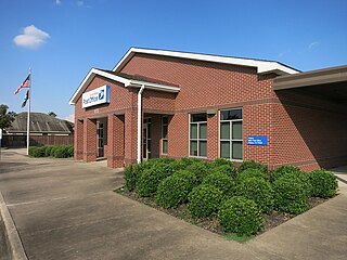
Fresno is an unincorporated community and census-designated place (CDP) in Fort Bend County, Texas, United States. The local population was 24,486 as of the 2020 census, up from 19,069 at the 2010 census, and 6,603 at the 2000 census.
Brownstown is an unincorporated community and census-designated place (CDP) in West Earl Township, Lancaster County, Pennsylvania, United States. As of the 2010 census, the population was 2,816.
Saint Onge is an unincorporated community and census-designated place (CDP) in Lawrence County, South Dakota, United States. As of the 2020 census, the population was 170.
Winfred is an unincorporated community and census-designated place (CDP) in Lake County, South Dakota, United States, approximately 12 miles (19 km) west of Madison. The population was 38 as of the 2020 census. Winfred has been assigned the ZIP code of 57076.

Summerset is a city in Meade County, South Dakota, United States. The population was 2,972 at the 2020 census. Located in the western part of the state, it is the first city to incorporate in the state since 1985.

Damariscotta is a census-designated place (CDP) comprising the main village of the town of Damariscotta in Lincoln County, Maine, United States. The population was 1,142 at the 2010 census, out of 2,218 in the entire town. In the 2000 census, the village was part of the Damariscotta-Newcastle CDP.
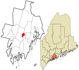
Newcastle is a census-designated place (CDP) comprising the main village of the town of Newcastle in Lincoln County, Maine, United States. The population was 667 at the 2010 census, out of 1,752 in the entire town. In the 2000 census, the village was part of the Damariscotta-Newcastle CDP.
Bijou Hills is an unincorporated community and census-designated place in Brule County, South Dakota, United States. The population was 2 according to the 2020 census.
Ola is an unincorporated community and census-designated place in Brule County, South Dakota, United States. The population was 15 according to the 2020 census.
Blucksberg Mountain is an unincorporated community and census-designated place in Meade County, South Dakota, United States. Its population was 467 as of the 2020 census. Interstate 90 passes through the community.
Brant Lake South is a census-designated place (CDP) in Lake County, South Dakota, United States. The population was 140 at the 2020 census. It was established after the 2010 census.
Angostura is an unincorporated area and census-designated place (CDP) in Fall River County, South Dakota, United States. The population was 159 at the 2020 census.
Horse Creek is an unincorporated community and census-designated place (CDP) in Mellette County, South Dakota, United States. It was first listed as a CDP prior to the 2020 census. The population of the CDP was 187 at the 2020 census.
Bridger is an unincorporated community and census-designated place (CDP) in Ziebach County, South Dakota, United States, within the Cheyenne River Indian Reservation. The population was 48 at the 2020 census. It was first listed as a CDP prior to the 2020 census.


