Beadle County, South Dakota

Last updated

Beadle County
Huron, SD, Chicago-Northwestern roundhouse, turntable 2.jpg
Map of South Dakota highlighting Beadle County.svg
Location within the U.S. state of South Dakota
South Dakota in United States.svg
South Dakota's location within the U.S.
Coordinates: 44°25′N98°17′W / 44.41°N 98.28°W / 44.41; -98.28
CountryFlag of the United States.svg United States
StateFlag of South Dakota.svg  South Dakota
Founded1879 (created)
1880 (organized)
Named for William Henry Harrison Beadle
Seat Huron
Largest cityHuron
Area
  Total1,265 sq mi (3,280 km2)
  Land1,259 sq mi (3,260 km2)
  Water6.1 sq mi (16 km2)  0.5%
Population
 (2020)
  Total19,149
  Estimate 
(2023)
19,591 Increase2.svg
  Density15/sq mi (5.8/km2)
Time zone UTC−6 (Central)
  Summer (DST) UTC−5 (CDT)
Congressional district At-large
Website beadle.sdcounties.org

Beadle County is a county in the U.S. state of South Dakota. As of the 2020 census, the population was 19,149, making it the 11th most populous county in South Dakota. [1] Its county seat is Huron. [2] The county was created in 1879 and organized in 1880. [3] Beadle County comprises the Huron, SD Micropolitan Statistical Area.

Contents

History

Beadle County, named for Brigadier General William Henry Harrison Beadle, [4] was created by the Dakota Territory Legislature in 1879, and was organized in 1880 with the appointment of three county commissioners by Governor Nehemiah G. Ordway. The first town within Beadle County was Cavour, but Huron was named the county seat when the county commissioners first met there in July 1880.

Geography

The James River flows south-southeastward through the eastern central part of Beadle County. [5] The terrain of Beadle County consists of low rolling hills, sloping toward the river valley. The county's highest point is its SW corner, at 1,841 ft (561 m) ASL. Its lowest point is on the south boundary line, where James River flows into adjacent Sanborn County, at 1,230 ft (370 m) ASL. [6]

The county has a total area of 1,265 square miles (3,280 km2), of which 1,259 square miles (3,260 km2) is land and 6.1 square miles (16 km2) (0.5%) is water. [7]

Major highways

Adjacent counties

Protected areas

  • Bob Roe Memorial State Game Production Area
  • Brecken Slough State Game Production Area
  • Cavour Lake State Game Production Area
  • James River School State game Production Area
  • Lake Byron Hogsback State Game Production Area
  • Mallard Slough State Game Production Area
  • Mud Lake State Game Production Area
  • North Byron State Game Production Area
  • Norwegian/Borden State Game Production Area
  • Pheasant Country State Game Production Area
  • Sand Creek State Game Production Area
  • South Byron State Game Production Area
  • South James River State Game Production Area
  • Staum Dam State Game Production Area
  • Third Street Dam State Game Production Area
  • Upper Cain Creek State Game Production Area

Demographics

Historical population
CensusPop.Note
1880 1,290
1890 9,586643.1%
1900 8,081−15.7%
1910 15,77695.2%
1920 19,27322.2%
1930 22,91718.9%
1940 19,648−14.3%
1950 21,0827.3%
1960 21,6822.8%
1970 20,877−3.7%
1980 19,195−8.1%
1990 18,253−4.9%
2000 17,023−6.7%
2010 17,3982.2%
2020 19,14910.1%
2023 (est.)19,591 [8] 2.3%
U.S. Decennial Census [9]
1790-1960 [10] 1900-1990 [11]
1990-2000 [12] 2010-2020 [1]

2020 census

As of the 2020 census, there were 10,149 people, 7,369 households, and 4,623 families residing in the county. [13] The population density was 15.2 inhabitants per square mile (5.9/km2). There were 8,396 housing units.

2010 census

As of the 2010 census, there were 17,398 people, 7,276 households, and 4,509 families residing in the county. The population density was 13.8 inhabitants per square mile (5.3/km2). There were 8,304 housing units at an average density of 6.6 per square mile (2.5/km2). The racial makeup of the county was 89.7% white, 3.6% Asian, 1.1% American Indian, 0.8% black or African American, 0.1% Pacific islander, 3.0% from other races, and 1.6% from two or more races. Those of Hispanic or Latino origin made up 7.7% of the population. In terms of ancestry, 45.4% were German, 11.7% were Norwegian, 10.3% were Irish, 8.8% were English, and 4.1% were American.

Of the 7,276 households, 28.6% had children under the age of 18 living with them, 49.5% were married couples living together, 8.3% had a female householder with no husband present, 38.0% were non-families, and 33.0% of all households were made up of individuals. The average household size was 2.31 and the average family size was 2.92. The median age was 41.2 years.

The median income for a household in the county was $40,716 and the median income for a family was $56,288. Males had a median income of $37,020 versus $25,824 for females. The per capita income for the county was $23,409. About 6.3% of families and 13.1% of the population were below the poverty line, including 12.8% of those under age 18 and 12.5% of those age 65 or over.

Communities

Cities

Towns

Census-designated places

Townships

  • Allen
  • Altoona
  • Banner
  • Barrett
  • Belle Prairie
  • Bonilla
  • Broadland
  • Burr Oak
  • Carlyle
  • Cavour
  • Clifton
  • Clyde
  • Custer
  • Dearborn
  • Fairfield
  • Foster
  • Grant
  • Hartland
  • Huron
  • Iowa
  • Kellogg
  • Lake Byron
  • Liberty
  • Logan
  • Milford
  • Nance
  • Pearl Creek
  • Pleasant View
  • Richland
  • Sand Creek
  • Theresa
  • Valley
  • Vernon
  • Wessington
  • Whiteside
  • Wolsey

Politics

Beadle County has become more Republican in recent history. In 2000, George W. Bush won the county, ending a streak of Democratic-majority voting that began in 1990.

United States presidential election results for Beadle County, South Dakota [14]
Year Republican Democratic Third party
No.%No.%No.%
2020 4,80867.90%2,10729.76%1662.34%
2016 4,45565.79%1,91228.23%4055.98%
2012 4,23058.24%2,88139.67%1522.09%
2008 4,05452.55%3,49345.28%1672.16%
2004 4,91757.98%3,44340.60%1201.42%
2000 4,34756.17%3,21641.56%1762.27%
1996 3,67042.77%3,98446.43%92710.80%
1992 3,36336.81%3,92542.96%1,84820.23%
1988 4,61150.23%4,52349.27%460.50%
1984 5,87662.36%3,52337.39%230.24%
1980 5,92158.60%3,52134.85%6626.55%
1976 4,75849.22%4,84650.13%620.64%
1972 5,92257.81%4,29741.95%250.24%
1968 4,21442.66%5,35754.23%3073.11%
1964 4,05140.43%5,96859.57%00.00%
1960 5,91159.17%4,07940.83%00.00%
1956 5,21653.06%4,61446.94%00.00%
1952 6,48765.33%3,44334.67%00.00%
1948 3,66245.15%4,37253.90%770.95%
1944 3,61048.44%3,84251.56%00.00%
1940 4,35645.33%5,25354.67%00.00%
1936 2,96532.90%5,84364.84%2032.25%
1932 2,99532.05%6,24666.83%1051.12%
1928 5,09461.43%3,16838.20%310.37%
1924 3,46653.37%85113.10%2,17733.52%
1920 2,85256.54%92518.34%1,26725.12%
1916 1,66245.72%1,82850.29%1453.99%
1912 00.00%1,46445.85%1,72954.15%
1908 1,77658.50%1,10536.40%1555.11%
1904 1,81873.78%49320.01%1536.21%
1900 1,22055.56%91541.67%612.78%
1896 93549.89%91548.83%241.28%
1892 98452.85%20611.06%67236.09%

See also

Related Research Articles

<span class="mw-page-title-main">Walworth County, South Dakota</span> County in South Dakota, United States

Walworth County is a county in the U.S. state of South Dakota. As of the 2020 census, the population was 5,315. Its county seat is Selby. The county was created in 1873 and organized in 1883. It is named for Walworth County, Wisconsin.

<span class="mw-page-title-main">Stanley County, South Dakota</span> County in South Dakota, United States

Stanley County is a county in the U.S. state of South Dakota. As of the 2020 census, the population was 2,980. Its county seat is Fort Pierre. The county was created in 1873, and was organized in 1890. It is named for David S. Stanley, a commander at Fort Sully from 1866 to 1874, which was located nearby.

<span class="mw-page-title-main">Spink County, South Dakota</span> County in South Dakota, United States

Spink County is a county in the U.S. state of South Dakota. As of the 2020 census, the population was 6,361. Its county seat is Redfield. The county was created in 1873, and was organized in 1879 within Dakota Territory.

<span class="mw-page-title-main">Moody County, South Dakota</span> County in South Dakota, United States

Moody County is a county in the U.S. state of South Dakota, United States. The population was 6,336 at the 2020 census. Its county seat is Flandreau. The county is named for Gideon C. Moody.

<span class="mw-page-title-main">Minnehaha County, South Dakota</span> County in South Dakota, United States

Minnehaha County is a county on the eastern border of the state of South Dakota. As of the 2020 census, the population was 197,214, making it the state's most populous county. It contains over 20% of the state's population. Its county seat is Sioux Falls, South Dakota's most populous city. The county was created in 1862 and organized in 1868. Its name was derived from the Sioux word Mnihaha, meaning "rapid water," or "waterfall".

<span class="mw-page-title-main">McPherson County, South Dakota</span> County in South Dakota, United States

McPherson County is a county in the U.S. state of South Dakota. As of the 2020 census, the population was 2,411. Its county seat is Leola.

<span class="mw-page-title-main">Marshall County, South Dakota</span> County in South Dakota, United States

Marshall County is a county in the U.S. state of South Dakota. As of the 2020 census, the population was 4,306. Its county seat is Britton. The county was created on May 2, 1885, and was named for Marshall Vincent, who homesteaded near Andover, South Dakota.

<span class="mw-page-title-main">Jones County, South Dakota</span> County in South Dakota, United States

Jones County is a county in the U.S. state of South Dakota. As of the 2020 census, the population was 917, making it the least populous county in South Dakota. Its county seat is Murdo. Created in 1916 and organized in 1917, it is the most recently established county in South Dakota. It was named after Granville Whittington Jones, an Arkansas-born clergyman/lawyer, who moved to Chamberlain, SD and became a noted Chautauqua speaker.

<span class="mw-page-title-main">Jerauld County, South Dakota</span> County in South Dakota, United States

Jerauld County is a county in the U.S. state of South Dakota. As of the 2020 census, the population was 1,663. Its county seat is Wessington Springs.

<span class="mw-page-title-main">Hughes County, South Dakota</span> County in South Dakota, United States

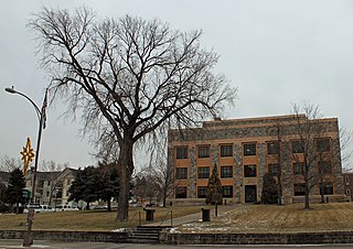
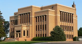
Hughes County is a county in the U.S. state of South Dakota. As of the 2020 census, the population was 17,765, making it the least populous capital county in the nation, and the 12th most populous county in South Dakota. Its county seat is Pierre, which is also the state capital. The county was created in 1873, and was organized in 1880. It was named for Alexander Hughes, a legislator. On June 4, 1891, the county's area was increased by the addition of Farm Island, in the Missouri River downstream of Pierre.

<span class="mw-page-title-main">Hand County, South Dakota</span> County in South Dakota, United States

Hand County is a county in the U.S. state of South Dakota. As of the 2020 census, the population was 3,145. Its county seat is Miller.

<span class="mw-page-title-main">Gregory County, South Dakota</span> County in South Dakota, United States

Gregory County is a county in the U.S. state of South Dakota. As of the 2020 census, the population was 3,994. Its county seat is Burke. The county was created in 1862 and organized in 1898. It was named for the politician J. Shaw Gregory.

<span class="mw-page-title-main">Faulk County, South Dakota</span> County in South Dakota, United States

Faulk County is a county in the U.S. state of South Dakota. As of the 2020 census, the population was 2,125. Its county seat is Faulkton. The county was founded in 1873 and organized in 1883. It is named for Andrew Jackson Faulk, the third Governor of Dakota Territory.

<span class="mw-page-title-main">Charles Mix County, South Dakota</span> County in South Dakota, United States

Charles Mix County is a county in the U.S. state of South Dakota. As of the 2020 census, the population was 9,373. Its county seat is Lake Andes. The county was created in 1862 and organized in 1879. It was named for Charles Eli Mix, an official of the Bureau of Indian Affairs influential in signing a peace treaty with the local Lakota Indian tribes. The easternmost approximately 60% of the county comprises the Yankton Indian Reservation.

<span class="mw-page-title-main">Brule County, South Dakota</span> County in South Dakota, United States

Brule County is a county in the U.S. state of South Dakota. As of the 2020 census, the population was 5,247. Its county seat is Chamberlain.

<span class="mw-page-title-main">Brookings County, South Dakota</span> County in South Dakota, United States

Brookings County is a county in the U.S. state of South Dakota. As of the 2020 census, the population was 34,375, making it the fifth most populous county in South Dakota. Its county seat is Brookings. The county was created in 1862 and organized in 1871.

<span class="mw-page-title-main">Cavour, South Dakota</span> Town in South Dakota, United States

Cavour is a town in Beadle County, South Dakota, United States. The population was 128 at the 2020 census.

<span class="mw-page-title-main">Huron, South Dakota</span> City in the United States

Huron is a city in and the county seat of Beadle County, South Dakota, United States. The population was 14,263 at the 2020 census, and it is the 8th most populous city in South Dakota.

<span class="mw-page-title-main">Wessington Springs, South Dakota</span> Town in South Dakota, United States

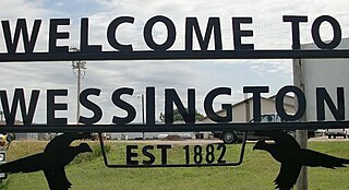
Wessington Springs is a town in central Jerauld County, South Dakota, United States. The population was 956 at the 2010 census. It is the county seat of Jerauld County.

<span class="mw-page-title-main">Wessington, South Dakota</span> City in South Dakota, United States

Wessington is a city on the border between Beadle and Hand counties in South Dakota, United States. The population was 197 at the 2020 census.

References

  1. 1 2 "State & County QuickFacts". United States Census Bureau. Retrieved March 22, 2024.
  2. "Find a County". National Association of Counties. Archived from the original on July 4, 2012. Retrieved June 7, 2011.
  3. "Dakota Territory, South Dakota, and North Dakota: Individual County Chronologies". Dakota Territory Atlas of Historical County Boundaries. The Newberry Library. 2006. Archived from the original on April 2, 2018. Retrieved March 28, 2015.
  4. History of the Origin of the Place Names in Nine Northwestern States. 1908. p. 11.
  5. Beadle County SD Google Maps (accessed January 30, 2019)
  6. ""Find an Altitude" Google Maps (accessed January 30, 2019)". Archived from the original on May 21, 2019. Retrieved January 30, 2019.
  7. "2010 Census Gazetteer Files". United States Census Bureau. August 22, 2012. Retrieved March 22, 2015.
  8. "County Population Totals and Components of Change: 2020-2023" . Retrieved March 17, 2024.
  9. "U.S. Decennial Census". United States Census Bureau. Retrieved March 22, 2015.
  10. "Historical Census Browser". University of Virginia Library. Retrieved March 22, 2015.
  11. Forstall, Richard L., ed. (March 27, 1995). "Population of Counties by Decennial Census: 1900 to 1990". United States Census Bureau. Retrieved March 22, 2015.
  12. "Census 2000 PHC-T-4. Ranking Tables for Counties: 1990 and 2000" (PDF). United States Census Bureau. April 2, 2001. Archived (PDF) from the original on October 9, 2022. Retrieved March 22, 2015.
  13. "US Census Bureau, Table P16: Household Type". United States Census Bureau. Retrieved March 22, 2024.
  14. Election Results

Bibliography

44°25′N98°17′W / 44.41°N 98.28°W / 44.41; -98.28