Lake County, South Dakota

Last updated

Lake County
Lake County Court House, Madison, South Dakota (75660).jpg
Lake County Court House
Map of South Dakota highlighting Lake County.svg
Location within the U.S. state of South Dakota
South Dakota in United States.svg
South Dakota's location within the U.S.
Coordinates: 44°01′N97°07′W / 44.02°N 97.12°W / 44.02; -97.12
CountryFlag of the United States.svg United States
StateFlag of South Dakota.svg  South Dakota
Founded1873
Seat Madison
Largest cityMadison
Area
  Total575 sq mi (1,490 km2)
  Land563 sq mi (1,460 km2)
  Water12 sq mi (30 km2)  2.1%
Population
 (2020)
  Total11,059
  Estimate 
(2023)
11,031 Decrease2.svg
  Density19/sq mi (7.4/km2)
Time zone UTC−6 (Central)
  Summer (DST) UTC−5 (CDT)
Congressional district At-large
Website www.lake.sd.gov

Lake County is a county in the U.S. state of South Dakota. As of the 2020 census, the population was 11,059. [1] Its county seat is Madison. [2] The county was formed in 1873. [3]

Contents

Geography

The terrain of Lake County consists of rolling hills, with the area devoted to agriculture. A tributary of the East Fork Vermillion River flows south-southeastward through the lower western part of the county, and Buffalo Creek flows southeastward from the central part of the county, leaving the county near its southeast corner. [4] The terrain generally slopes to the south, although high points (ca. 1,814' ASL) are found on the north and south boundary lines and points between. [5]

Lake County has a total area of 575 square miles (1,490 km2), of which 563 square miles (1,460 km2) is land and 12 square miles (31 km2) (2.1%) is water. [6]

Lakes [4]

Protected areas [4]

Major highways

Adjacent counties

Demographics

Historical population
CensusPop.Note
1880 2,657
1890 7,508182.6%
1900 9,13721.7%
1910 10,71117.2%
1920 12,25714.4%
1930 12,3791.0%
1940 12,4120.3%
1950 11,792−5.0%
1960 11,764−0.2%
1970 11,456−2.6%
1980 10,724−6.4%
1990 10,550−1.6%
2000 11,2766.9%
2010 11,200−0.7%
2020 11,059−1.3%
2023 (est.)11,031 [7] −0.3%
U.S. Decennial Census [8]
1790-1960 [9] 1900-1990 [10]
1990-2000 [11] 2010-2020 [1]

2020 census

As of the 2020 census, there were 11,059 people, 4,576 households, and 2,804 families residing in the county. [12] The population density was 19.6 inhabitants per square mile (7.6/km2). There were 5,658 housing units.

2010 census

As of the 2010 census, there were 11,200 people, 4,483 households, and 2,814 families in the county. The population density was 19.9 inhabitants per square mile (7.7/km2). There were 5,559 housing units at an average density of 9.9 units per square mile (3.8 units/km2). The racial makeup of the county was 96.2% white, 0.7% Asian, 0.7% American Indian, 0.5% black or African American, 0.8% from other races, and 1.1% from two or more races. Those of Hispanic or Latino origin made up 1.6% of the population. In terms of ancestry, 50.7% were German, 20.6% were Norwegian, 12.4% were Irish, 6.6% were English, 6.2% were Dutch, 5.0% were Danish, and 5.0% were American.

Of the 4,483 households, 26.7% had children under the age of 18 living with them, 53.0% were married couples living together, 6.8% had a female householder with no husband present, 37.2% were non-families, and 30.9% of all households were made up of individuals. The average household size was 2.30 and the average family size was 2.88. The median age was 39.9 years.

The median income for a household in the county was $45,606 and the median income for a family was $57,753. Males had a median income of $36,370 versus $25,898 for females. The per capita income for the county was $22,447. About 6.5% of families and 12.1% of the population were below the poverty line, including 12.8% of those under age 18 and 8.8% of those age 65 or over.

Communities

City

Towns

Village

Census-designated places

Other unincorporated communities [4]

Townships

  • Badus
  • Chester
  • Clarno
  • Concord
  • Farmington
  • Franklin
  • Herman
  • Lake View
  • Le Roy
  • Nunda
  • Orland
  • Rutland
  • Summit
  • Wayne
  • Wentworth
  • Winfred

Historical townsite

Politics

Lake County voters have voted for Republican Party candidates in 62 percent of national elections since 1964.

United States presidential election results for Lake County, South Dakota [14]
Year Republican Democratic Third party
No.%No.%No.%
2020 3,68162.68%2,06835.21%1242.11%
2016 4,03859.50%2,31434.10%4346.40%
2012 3,41954.40%2,72443.34%1422.26%
2008 2,99348.61%3,03349.26%1312.13%
2004 3,35955.92%2,50941.77%1392.31%
2000 2,72452.85%2,33145.23%991.92%
1996 1,96638.41%2,52649.36%62612.23%
1992 1,89033.81%2,38842.72%1,31223.47%
1988 2,43947.62%2,66351.99%200.39%
1984 3,02755.92%2,36743.73%190.35%
1980 3,09352.85%2,20737.71%5529.43%
1976 2,53046.20%2,93053.51%160.29%
1972 2,91950.14%2,88649.57%170.29%
1968 2,87653.68%2,29442.81%1883.51%
1964 2,41744.72%2,98855.28%00.00%
1960 3,52061.28%2,22438.72%00.00%
1956 3,40462.32%2,05837.68%00.00%
1952 4,02073.28%1,46626.72%00.00%
1948 2,83756.95%2,09342.01%521.04%
1944 2,95665.70%1,54334.30%00.00%
1940 4,17968.87%1,88931.13%00.00%
1936 3,18252.95%2,52041.94%3075.11%
1932 2,22241.09%3,09057.15%951.76%
1928 3,04863.41%1,74436.28%150.31%
1924 1,88845.35%2977.13%1,97847.51%
1920 2,33369.98%39811.94%60318.09%
1916 1,39855.04%1,02740.43%1154.53%
1912 00.00%65733.50%1,30466.50%
1908 1,41565.60%63629.49%1064.91%
1904 1,72878.90%26011.87%2029.22%
1900 1,17255.57%90142.72%361.71%
1896 86446.10%99953.31%110.59%
1892 74243.47%19611.48%76945.05%

See also

Related Research Articles

<span class="mw-page-title-main">Yankton County, South Dakota</span> County in South Dakota, United States

Yankton County is a county in the U.S. state of South Dakota. As of the 2020 census, the population was 23,310, making it the 9th most populous county in South Dakota. Its county seat is Yankton. Yankton County comprises the Yankton, SD Micropolitan Statistical Area.

<span class="mw-page-title-main">Stanley County, South Dakota</span> County in South Dakota, United States

Stanley County is a county in the U.S. state of South Dakota. As of the 2020 census, the population was 2,980. Its county seat is Fort Pierre. The county was created in 1873, and was organized in 1890. It is named for David S. Stanley, a commander at Fort Sully from 1866 to 1874, which was located nearby.

<span class="mw-page-title-main">Lincoln County, South Dakota</span> County in South Dakota, United States

Lincoln County is a county in the U.S. state of South Dakota. As of the 2020 census, the population was 65,161, making it the third most populous county in South Dakota. Its county seat is Canton. The county was named for Abraham Lincoln, 16th President of the United States.

<span class="mw-page-title-main">Hyde County, South Dakota</span> County in South Dakota, United States

Hyde County is a county in the U.S. state of South Dakota. As of the 2020 census, the population was 1,262, making it the second-least populous county in South Dakota. Its county seat is Highmore. The county was founded in 1873, as a county of the Dakota Territory, and organized in 1883. It was named for James Hyde, a member of legislature in the 1870s.

<span class="mw-page-title-main">Hanson County, South Dakota</span> County in the United States

Hanson County is a county in the U.S. state of South Dakota. As of the 2020 census, the population was 3,461. Its county seat is Alexandria. The county was founded in 1871 and organized in 1873. It was named for Joseph R. Hanson, clerk of the first legislature.

<span class="mw-page-title-main">Hand County, South Dakota</span> County in South Dakota, United States

Hand County is a county in the U.S. state of South Dakota. As of the 2020 census, the population was 3,145. Its county seat is Miller.

<span class="mw-page-title-main">Hamlin County, South Dakota</span> County in South Dakota, United States

Hamlin County is a county in the U.S. state of South Dakota. As of the 2020 census, the population was 6,164. Its county seat is Hayti. The county was created in 1873 and organized in 1878. It was named for Hannibal Hamlin, Lincoln's first vice-president.

<span class="mw-page-title-main">Gregory County, South Dakota</span> County in South Dakota, United States

Gregory County is a county in the U.S. state of South Dakota. As of the 2020 census, the population was 3,994. Its county seat is Burke. The county was created in 1862 and organized in 1898. It was named for the politician J. Shaw Gregory.

<span class="mw-page-title-main">Grant County, South Dakota</span> County in South Dakota, United States

Grant County is a county in the U.S. state of South Dakota. As of the 2020 census, the population was 7,556. The county seat is Milbank. The county was founded in 1873 and organized in 1878. It is named for Ulysses S. Grant, 18th President of the United States.

<span class="mw-page-title-main">Dewey County, South Dakota</span> County in South Dakota, United States

Dewey County is a county in the U.S. state of South Dakota. As of the 2020 census, the population was 5,239. Its county seat is Timber Lake. The county was created in 1883 and organized in 1910. It was named for William P. Dewey, Territorial surveyor-general from 1873 to 1877.

<span class="mw-page-title-main">Davison County, South Dakota</span> County in South Dakota, United States

Davison County is a county in the U.S. state of South Dakota. As of the 2020 census, the population was 19,956, making it the 10th most populous county in South Dakota. Its county seat is Mitchell. The county was created in 1873 and organized in 1874. It was named for Henry C. Davison, the first settler in the county.

<span class="mw-page-title-main">Brookings County, South Dakota</span> County in South Dakota, United States

Brookings County is a county in the U.S. state of South Dakota. As of the 2020 census, the population was 34,375, making it the fifth most populous county in South Dakota. Its county seat is Brookings. The county was created in 1862 and organized in 1871.

<span class="mw-page-title-main">Beadle County, South Dakota</span> County in South Dakota, United States

Beadle County is a county in the U.S. state of South Dakota. As of the 2020 census, the population was 19,149, making it the 11th most populous county in South Dakota. Its county seat is Huron. The county was created in 1879 and organized in 1880. Beadle County comprises the Huron, SD Micropolitan Statistical Area.

<span class="mw-page-title-main">McLean County, North Dakota</span> County in North Dakota, United States

McLean County is a county in the U.S. state of North Dakota. As of the 2020 census, the population was 9,771. Its county seat is Washburn.

<span class="mw-page-title-main">Foster County, North Dakota</span> County in North Dakota, United States

Foster County is a county in the U.S. state of North Dakota. As of the 2020 census, the population was 3,397. Its county seat is Carrington.

<span class="mw-page-title-main">Bottineau County, North Dakota</span> County in North Dakota, United States

Bottineau County is a county in the U.S. state of North Dakota. As of the 2020 census, the population was 6,379. Its county seat is Bottineau.

<span class="mw-page-title-main">Santa Clara, New York</span> Town in New York, United States

Santa Clara is a town in Franklin County, New York, United States. The population was 345 at the 2010 census. The name was derived from the wife of an early town businessman, John Hurd.

<span class="mw-page-title-main">Madison, South Dakota</span> City in South Dakota, United States

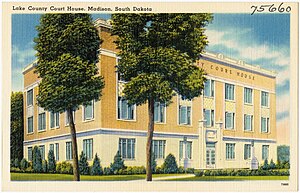
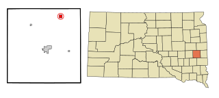
Madison is a city in Lake County, South Dakota, United States. The population was 6,191 at the 2020 census. It is the county seat of Lake County and is home to Dakota State University.

<span class="mw-page-title-main">Nunda, South Dakota</span> Town in South Dakota, United States

Nunda is a village in Lake County, South Dakota, United States. The population was 46 at the 2020 census. Located there are a post office, grainery, bar and grill, and an American Legion post.

Nunda is a town in Livingston County, New York, United States. The population was 3,064 at the 2010 census. Nunda welcomes visitors with signs stating "Welcome to Nunda, a Nice Place to Live." The name is derived from Nunda-wa-ono, the name given to it by a group of the Seneca people who once lived in the hills and valleys along the Genesee River and Keshequa Creek within the present-day town. In the Seneca language, "Nunda" relates to hills, and a popular translation is "Where the valley meets the hills".

References

  1. 1 2 "State & County QuickFacts". United States Census Bureau. Retrieved March 21, 2024.
  2. "Find a County". National Association of Counties. Retrieved June 7, 2011.
  3. "Dakota Territory, South Dakota, and North Dakota: Individual County Chronologies". Dakota Territory Atlas of Historical County Boundaries. The Newberry Library. 2006. Archived from the original on April 2, 2018. Retrieved March 30, 2015.
  4. 1 2 3 4 "Lake County · South Dakota". Google Maps. Retrieved April 27, 2024.
  5. ""Find an Altitude" Google Maps (accessed February 5, 2019)". Archived from the original on May 21, 2019. Retrieved February 5, 2019.
  6. "2010 Census Gazetteer Files". United States Census Bureau. August 22, 2012. Retrieved March 28, 2015.
  7. "County Population Totals and Components of Change: 2020-2023" . Retrieved March 17, 2024.
  8. "U.S. Decennial Census". United States Census Bureau. Retrieved March 28, 2015.
  9. "Historical Census Browser". University of Virginia Library. Retrieved March 28, 2015.
  10. Forstall, Richard L., ed. (March 27, 1995). "Population of Counties by Decennial Census: 1900 to 1990". United States Census Bureau. Retrieved March 28, 2015.
  11. "Census 2000 PHC-T-4. Ranking Tables for Counties: 1990 and 2000" (PDF). United States Census Bureau. April 2, 2001. Archived (PDF) from the original on October 9, 2022. Retrieved March 28, 2015.
  12. "US Census Bureau, Table P16: Household Type". United States Census Bureau. Retrieved March 21, 2024.
  13. Saranac (historical) in Lake County SD SD Home Town Locator (accessed February 5, 2019)
  14. Leip, David. "Atlas of US Presidential Elections". uselectionatlas.org. Retrieved April 15, 2018.

44°01′N97°07′W / 44.02°N 97.12°W / 44.02; -97.12