Oglala Lakota County, South Dakota

Last updated

Oglala Lakota County
Pine Ridge Indian Health Service Hospital.jpg
Indian Health Service Hospital in Pine Ridge on the Pine Ridge Indian Reservation, November 2011
Map of South Dakota highlighting Oglala Lakota County.svg
Location within the U.S. state of South Dakota
South Dakota in United States.svg
South Dakota's location within the U.S.
Coordinates: 43°20′N102°33′W / 43.33°N 102.55°W / 43.33; -102.55
CountryFlag of the United States.svg United States
StateFlag of South Dakota.svg  South Dakota
Founded1875
Named for Oglala Lakota people
Seat None (de jure)
Hot Springs (de facto) [1]
Largest community Pine Ridge
Area
  Total2,097 sq mi (5,430 km2)
  Land2,094 sq mi (5,420 km2)
  Water2.8 sq mi (7 km2)  0.1%
Population
 (2020)
  Total13,672
  Estimate 
(2023)
13,434 Decrease2.svg
  Density6.5/sq mi (2.5/km2)
Time zone UTC−7 (Mountain)
  Summer (DST) UTC−6 (MDT)
Congressional district At-large
Website oglalalakota.sdcounties.org
Hot Springs in neighboring Fall River County serves as administrative center for county [1]

Oglala Lakota County (known as Shannon County until May 2015) [2] is a county in southwestern South Dakota, United States. As of the 2020 census, the population was 13,672. [3] Oglala Lakota County does not have a functioning county seat; Hot Springs in neighboring Fall River County serves as its administrative center. [1] The county was created as a part of the Dakota Territory in 1875, although it remains unorganized. [4] [5] Its largest community is Pine Ridge.

Contents

The county lies entirely within the Pine Ridge Indian Reservation and contains part of Badlands National Park. It is one of five South Dakota counties entirely on an Indian reservation. [6]

The county is named after the Oglala Lakota, a band of the Lakota people. Many of the county's inhabitants are members of this sub-tribe.

Reservation poverty affects the county, which is the poorest county in the US (only 28 county-equivalents in the U.S. territories are poorer). Oglala Lakota County is the only dry county in South Dakota.

The newspaper for Oglala Lakota County is The Lakota Country Times. [7] [8]

History

The Wounded Knee Massacre occurred in Oglala Lakota County in 1890.

The county was originally named for Peter C. Shannon, Chief Justice of the Dakota Territory Supreme Court. Until 1982, Shannon County and Washabaugh County, South Dakota, were the last unorganized counties in the United States. Although it was organized and received a home rule charter that year, the county, as noted above, contracts with Fall River County for its Auditor, Treasurer, and Registrar of Deeds. [9]

On November 4, 2014, voters in the county voted by a margin of 2,161 to 526 to rename Shannon County to Oglala Lakota County. [10] The name change was ratified by the state legislature on March 5, 2015. [11] May 1, 2015 was proclaimed by the governor as the official day for renaming the county. [12]

Geography

Locator map of populated places in Oglala Lakota County Map of Oglala Lakota County, South Dakota.png
Locator map of populated places in Oglala Lakota County

Oglala Lakota County lies on the south side of South Dakota. Its south boundary line abuts the north boundary line of the state of Nebraska. The Cheyenne River flows northeastward along the northwest boundary of Oglala Lakota County. The White River flows northeastward through the central part of the county. The county terrain is composed of semi-arid rolling hills spotted with small mountain crests, oriented NE-SW. [13] The terrain slopes to the northeast; its highest point is on the south boundary line, close to the SW corner, at 3,619 ft (1,103 m) ASL. [14] The county has a total area of 2,097 square miles (5,430 km2), of which 2,094 square miles (5,420 km2) is land and 2.8 square miles (7.3 km2) (0.1%) is water. [15]

The county includes the headwaters of the Little White River.

Major highways

Adjacent counties

National protected area

Lakes

  • Alkali Lake
  • Denby Lake
  • Lee Lake
  • Oglala Lake
  • Two Lance Lake
  • Wakpamani Lake
  • White Clay Lake

Source: [13]

Demographics

Historical population
CensusPop.Note
1920 2,003
1930 4,058102.6%
1940 5,36632.2%
1950 5,6695.6%
1960 6,0005.8%
1970 8,19836.6%
1980 11,32338.1%
1990 9,902−12.5%
2000 12,46625.9%
2010 13,5869.0%
2020 13,6720.6%
2023 (est.)13,434 [16] −1.7%
U.S. Decennial Census [17]
1790-1960 [18] 1900-1990 [19]
1990-2000 [20] 2010-2020 [3]

2020 census

As of the 2020 census, there were 13,672 people, 3,208 households, and 2,488 families residing in the county. [21] The population density was 6.5 inhabitants per square mile (2.5/km2). There were 3,454 housing units.

2000 census

As of the 2000 census, there were 12,466 people, 2,785 households, and 2,353 families residing in the county. The population density was 6 people per square mile (2.3 people/km2). There were 3,123 housing units at an average density of 2 per square mile (0.77/km2). The racial makeup of the county was 4.51% White, 0.08% Black or African American, 94.20% American Indian, 0.02% Asian, 0.05% Pacific Islander, 0.22% from other races, and 0.91% from two or more races. Hispanic or Latino of any race were 1.42% of the population.

There were 2,785 households, out of which 51.70% had children under the age of 18 living with them, 35.40% were married couples living together, 36.40% had a female householder with no husband present, and 15.50% were non-families. 13.20% of all households were made up of individuals, and 3.00% had someone living alone who was 65 years of age or older. The average household size was 4.36 and the average family size was 4.72.

The county population contained 45.30% under the age of 18, 10.60% from 18 to 24, 25.60% from 25 to 44, 13.80% from 45 to 64, and 4.80% who were 65 years of age or older. The median age was 21 years. For every 100 females there were 99.60 males. For every 100 females age 18 and over, there were 95.60 males.

The median income for a household in the county was $20,916, and the median income for a family was $20,897. Males had a median income of $25,170 versus $22,594 for females. The per capita income for the county was $6,286. About 45.10% of families and 52.30% of the population were below the poverty line, including 60.80% of those under age 18 and 36.00% of those age 65 or over.

Health and life expectancy

Of 3,142 counties in the United States in 2014, Oglala Lakota County ranked last in the life expectancy of both male and female residents. Males in Oglala Lakota County lived an average of 62.8 years and females lived an average of 71.0 years compared to the national average for life expectancy of 76.7 for males and 81.5 for females. The average life expectancy in Oglala Lakota County increased by 6.2 for males and 4.1 years for females between 1980 and 2014, compared to an increase in the national average for the same period of an increased life span of 6.7 years for men and 3.9 years for women. [22] [23]

In 2021, the Robert Wood Johnson Foundation ranked Oglala Lakota County last of 61 counties in South Dakota in "health outcomes," as measured by length and quality of life. [24]

Politics

The counties surrounding Oglala Lakota County are predominantly Republican, but, like most Native American counties, residents of Oglala Lakota are mostly Democrats, giving over 75 percent of the vote to every Democratic presidential nominee in every election back to 1984, making it one of the most Democratic counties in the United States. No Republican has carried the county in a presidential election since 1952. In 2012, Oglala Lakota County (then known as Shannon) was the county with the highest percentage of vote for Barack Obama in the United States. [25] However, the local politics are a bit more divided: Oglala Lakota County lies within the 27th District of the South Dakota Legislature, represented by three Lakotas, two Democrats and one Republican. Democrat Red Dawn Foster represents the county in the Senate, while Democrat Peri Pourier and Republican Liz Marty May represent the county in the House.

United States presidential election results for Oglala Lakota County, South Dakota [26]
Year Republican Democratic Third party
No.%No.%No.%
2020 2979.28%2,82988.41%742.31%
2016 2418.30%2,51086.40%1545.30%
2012 1885.98%2,93793.39%200.64%
2008 3319.88%2,97188.69%481.43%
2004 52612.48%3,56684.62%1222.90%
2000 25212.90%1,66785.36%341.74%
1996 25311.08%1,92684.33%1054.60%
1992 22513.63%1,26776.74%1599.63%
1988 25617.31%1,20681.54%171.15%
1984 32417.71%1,48981.41%160.87%
1980 43825.96%1,13267.10%1176.94%
1976 30127.84%75669.94%242.22%
1972 35622.10%1,24677.34%90.56%
1968 53329.68%1,20266.93%613.40%
1964 55724.16%1,74875.84%00.00%
1960 65536.59%1,13563.41%00.00%
1956 78245.18%94954.82%00.00%
1952 95755.29%77444.71%00.00%
1948 64144.09%80355.23%100.69%
1944 56253.93%48046.07%00.00%
1940 1,09458.04%79141.96%00.00%
1936 66749.93%63447.46%352.62%
1932 46336.69%79863.23%10.08%
1928 46943.63%60155.91%50.47%
1924 99288.89%766.81%484.30%

Communities

Town

Census-designated places

Unincorporated communities [13]

Townships

There are no townships. The county is divided into two areas of unorganized territory: East Oglala Lakota and West Oglala Lakota (formerly East Shannon and West Shannon, respectively).

See also

Related Research Articles

<span class="mw-page-title-main">Ziebach County, South Dakota</span> County in South Dakota, United States

Ziebach County is a county in the U.S. state of South Dakota. As of the 2020 census, the population was 2,413. Its county seat is Dupree. It is the last county in the United States alphabetically.

<span class="mw-page-title-main">Todd County, South Dakota</span> County in South Dakota, United States

Todd County is a county in the U.S. state of South Dakota. As of the 2020 census, the population was 9,319. Todd County does not have its own county seat. Instead, Winner in neighboring Tripp County serves as its administrative center. Its largest city is Mission. The county was created in 1909, although it remains unorganized. The county was named for John Blair Smith Todd, a delegate from Dakota Territory to the United States House of Representatives and a Civil War general.

<span class="mw-page-title-main">Mellette County, South Dakota</span> County in South Dakota, United States

Mellette County is a county in the U.S. state of South Dakota. As of the 2020 census, the population was 1,918. Its county seat is White River. The county was created in 1909, and was organized in 1911. It was named for Arthur C. Mellette, the last Governor of the Dakota Territory and the first Governor of the state of South Dakota.

<span class="mw-page-title-main">Jackson County, South Dakota</span> County in South Dakota, United States

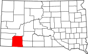
Jackson County is a county in the U.S. state of South Dakota. As of the 2020 census, the population was 2,806. Its county seat is Kadoka. The county was created in 1883, and was organized in 1915. Washabaugh County was merged into Jackson County in 1983.

<span class="mw-page-title-main">Fall River County, South Dakota</span> County in South Dakota, United States

Fall River County is a county in the U.S. state of South Dakota. As of the 2020 census, the population was 6,973. Its county seat is Hot Springs. The county was founded in 1883. It is named for Fall River which runs through it.

<span class="mw-page-title-main">Dewey County, South Dakota</span> County in South Dakota, United States

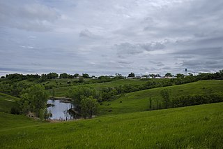
Dewey County is a county in the U.S. state of South Dakota. As of the 2020 census, the population was 5,239. Its county seat is Timber Lake. The county was created in 1883 and organized in 1910. It was named for William P. Dewey, Territorial surveyor-general from 1873 to 1877.

<span class="mw-page-title-main">Charles Mix County, South Dakota</span> County in South Dakota, United States

Charles Mix County is a county in the U.S. state of South Dakota. As of the 2020 census, the population was 9,373. Its county seat is Lake Andes. The county was created in 1862 and organized in 1879. It was named for Charles Eli Mix, an official of the Bureau of Indian Affairs influential in signing a peace treaty with the local Lakota Indian tribes. The easternmost approximately 60% of the county comprises the Yankton Indian Reservation.

<span class="mw-page-title-main">Bennett County, South Dakota</span> County in South Dakota, United States

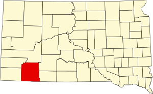
Bennett County is a county in the U.S. state of South Dakota. As of the 2020 census, the population was 3,381. Its county seat is Martin. The county lies completely within the exterior boundary of the Pine Ridge Indian Reservation. To the east is the Rosebud Indian Reservation, occupied by Sicangu Oyate, also known the Upper Brulé Sioux Nation and the Rosebud Sioux Tribe (RST), a branch of the Lakota people.

<span class="mw-page-title-main">Pembina County, North Dakota</span> County in North Dakota, United States

Pembina County is a county in the U.S. state of North Dakota. At the 2020 census its population was 6,844. The county seat is Cavalier.

<span class="mw-page-title-main">Nelson County, North Dakota</span> County in North Dakota, United States

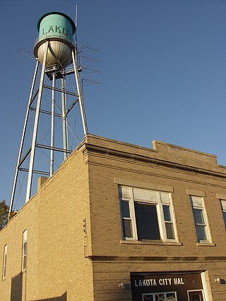
Nelson County is a county in the U.S. state of North Dakota. As of the 2020 census, the population was 3,015. Its county seat is Lakota.

<span class="mw-page-title-main">Hot Springs, South Dakota</span> City in South Dakota, United States

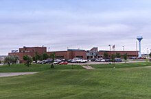
Hot Springs is a city in and county seat of Fall River County, South Dakota, United States. As of the 2020 census, the city population was 3,395. In addition, neighboring Oglala Lakota County contracts the duties of Auditor, Treasurer and Register of Deeds to the Fall River County authority in Hot Springs.

<span class="mw-page-title-main">Wanblee, South Dakota</span> Census-designated place in South Dakota, United States

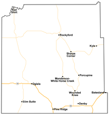
Wanblee is a census-designated place on the Pine Ridge Indian Reservation, located in Jackson County, South Dakota, United States. The population was 674 at the 2020 census, virtually all of whom are members of the Oglala band of Lakota Sioux. Wanbli is the Lakota word for eagle, and the town was named for its proximity to Wanbli hohpi paha. Wanblee is a few miles directly northeast of the North American continental pole of inaccessibility.

<span class="mw-page-title-main">Batesland, South Dakota</span> Town in South Dakota, United States

Batesland is a town in Oglala Lakota County, South Dakota, United States. The population was 100 at the 2020 census.

<span class="mw-page-title-main">Kyle, South Dakota</span> CDP in South Dakota, United States

Kyle is a census-designated place (CDP) in Oglala Lakota County, South Dakota, United States. Its population was 943 at the 2020 census. Located within the Pine Ridge Indian Reservation of the Oglala Lakota, it is one of two settlements which are closest to the North American continental pole of inaccessibility.

<span class="mw-page-title-main">Manderson-White Horse Creek, South Dakota</span> CDP in South Dakota, United States

Manderson-White Horse Creek is a census-designated place (CDP) in East Oglala Lakota Unorganized Territory in Oglala Lakota County, South Dakota, United States. The population was 554 at the 2020 census. Oglala Lakota tribesman, Kicking Bear died here on May 28, 1904. He fought in several battles during the Black Hills War, including Battle of the Greasy Grass. His nephew, Felix Flying Hawk owned a ranch.

<span class="mw-page-title-main">Oglala, South Dakota</span> CDP in South Dakota, United States

Oglala is a census-designated place (CDP) in West Oglala Lakota Unorganized Territory equivalent, Oglala Lakota County, South Dakota, United States. The population was 1,282 at the 2020 census. Its location is in the northwest of the Pine Ridge Indian Reservation.

<span class="mw-page-title-main">Pine Ridge, South Dakota</span> CDP in South Dakota, United States

Pine Ridge is a census-designated place (CDP) and the most populous community in Oglala Lakota County, South Dakota, United States. The population was 3,138 at the 2020 census. It is the tribal headquarters of the Oglala Sioux Tribe on the Pine Ridge Indian Reservation.

<span class="mw-page-title-main">Porcupine, South Dakota</span> CDP in South Dakota, United States

Porcupine is a census-designated place (CDP) in Oglala Lakota County, South Dakota, United States. The population was 925 at the 2020 census.

<span class="mw-page-title-main">Wounded Knee, South Dakota</span> CDP in South Dakota, United States

Wounded Knee is a census-designated place (CDP) on the Pine Ridge Indian Reservation in Oglala Lakota County, South Dakota, United States. The population was 364 at the 2020 census.

<span class="mw-page-title-main">Whiteclay, Nebraska</span> Census-designated place in Nebraska, United States

Whiteclay is a census-designated place in Sheridan County, Nebraska, United States. The population was 10 at the 2010 census.

References

  1. 1 2 3 "Oglala Lakota County, South Dakota". oglalalakota.sdcounties.org. Oglala Lakota County. Retrieved October 22, 2019.
  2. "Oglala Lakota County, South Dakota: About". oglalalakota.sdcounties.org. Oglala Lakota County. Retrieved October 22, 2019.
  3. 1 2 "State & County QuickFacts". United States Census Bureau. Retrieved March 21, 2024.
  4. "Dakota Territory, South Dakota, and North Dakota: Individual County Chronologies". Dakota Territory Atlas of Historical County Boundaries. The Newberry Library. 2006. Archived from the original on April 2, 2018. Retrieved March 30, 2015.
  5. "South Dakota Legislative Manual" (PDF). South Dakota Secretary of State. 2005. p. 597. Archived from the original (PDF) on March 29, 2015. Retrieved March 30, 2015.
  6. The other four SD counties entirely on reservations are Corson, Dewey, Todd, and Ziebach.
  7. "The Lakota Country Times". Lakota Country Times.
  8. "Martin Lakota Country Times". South Dakota Newspaper Association. Retrieved April 10, 2016.
  9. "Oglala Lakota (Shannon) County, South Dakota: History". www.e-referencedesk.com. Archived from the original on March 1, 2012. Retrieved April 15, 2018.
  10. Montgomery, David (November 5, 2014). "Shannon County no more: Voters approve name change". Argus Leader. Retrieved April 27, 2024.
  11. Mercer, Bob (March 5, 2015). "It's official: Oglala Lakota County replaces Shannon County Name". Rapid City Journal . Retrieved March 14, 2015.
  12. "Governor's Executive Proclamation". Office of the Governor.
  13. 1 2 3 Shannon County SD Google Maps (accessed February 7, 2019)
  14. ""Find an Altitude" Google Maps (accessed February 7, 2019)". Archived from the original on May 21, 2019. Retrieved February 8, 2019.
  15. "2010 Census Gazetteer Files". United States Census Bureau. August 22, 2012. Retrieved March 28, 2015.
  16. "County Population Totals and Components of Change: 2020-2023" . Retrieved March 17, 2024.
  17. "U.S. Decennial Census". United States Census Bureau. Retrieved March 28, 2015.
  18. "Historical Census Browser". University of Virginia Library. Retrieved March 28, 2015.
  19. Forstall, Richard L., ed. (March 27, 1995). "Population of Counties by Decennial Census: 1900 to 1990". United States Census Bureau. Retrieved March 28, 2015.
  20. "Census 2000 PHC-T-4. Ranking Tables for Counties: 1990 and 2000" (PDF). United States Census Bureau. April 2, 2001. Archived (PDF) from the original on October 9, 2022. Retrieved March 28, 2015.
  21. "US Census Bureau, Table P16: Household Type". United States Census Bureau. Retrieved March 21, 2024.
  22. "Oglala Lakota County, South Dakota" (PDF). Institute for Health Metrics and Evaluation. University of Washington. Archived (PDF) from the original on October 9, 2022. Retrieved April 12, 2022.
  23. "U.S. Health Map". Institute for Health Metrics and Evaluation. University of Washington. Retrieved April 12, 2022.
  24. "2021 South Dakota Report". Robert Wood Johnson Foundation. Retrieved April 12, 2022.
  25. "David Leip's Presidential Election Atlas – 2012 statistics". Uselectionatlas.org. Retrieved November 6, 2019.
  26. Leip, David. "Atlas of US Presidential Elections". uselectionatlas.org. Retrieved December 4, 2020.