Turner County, South Dakota

Last updated

Turner County
Turner County CH South Dakota 5.jpg
Turner County Courthouse in Parker
Map of South Dakota highlighting Turner County.svg
Location within the U.S. state of South Dakota
South Dakota in United States.svg
South Dakota's location within the U.S.
Coordinates: 43°19′N97°09′W / 43.31°N 97.15°W / 43.31; -97.15
CountryFlag of the United States.svg United States
StateFlag of South Dakota.svg  South Dakota
Founded1871
Named for John W. Turner
Seat Parker
Largest cityParker
Area
  Total618 sq mi (1,600 km2)
  Land617 sq mi (1,600 km2)
  Water0.6 sq mi (2 km2)  0.1%
Population
 (2020)
  Total8,673
  Estimate 
(2023)
9,027 Increase2.svg
  Density14/sq mi (5.4/km2)
Time zone UTC−6 (Central)
  Summer (DST) UTC−5 (CDT)
Congressional district At-large
Website turner.sdcounties.org

Turner County is a county in the U.S. state of South Dakota. As of the 2020 census, the population was 8,673. [1] Its county seat is Parker. [2] The county was established in 1871, and was named for Dakota Territory official John W. Turner. [3]

Contents

Turner County is a part of the Sioux Falls, SD Metropolitan Statistical Area.

Geography

The terrain of Turner County consists of rolling hills, carved by gullies and drainages. The area is largely devoted to agriculture. [4] The terrain slopes to the south and east; its highest point is along its west boundary line, at 1,578 ft (481 m) ASL. [5] The county has a total area of 618 square miles (1,600 km2), of which 617 square miles (1,600 km2) is land and 0.6 square miles (1.6 km2) (0.1%) is water. [6]

Major highways

Adjacent counties

Protected areas [4]

Lakes [4]

Demographics

Historical population
CensusPop.Note
1880 5,320
1890 10,25692.8%
1900 13,17528.5%
1910 13,8405.0%
1920 14,8717.4%
1930 14,8910.1%
1940 13,270−10.9%
1950 12,100−8.8%
1960 11,159−7.8%
1970 9,872−11.5%
1980 9,255−6.2%
1990 8,576−7.3%
2000 8,8493.2%
2010 8,347−5.7%
2020 8,6733.9%
2023 (est.)9,027 [7] 4.1%
U.S. Decennial Census [8]
1790-1960 [9] 1900-1990 [10]
1990-2000 [11] 2010-2020 [1]
Swan Lake northwest of Viborg Swan-lake-sd.jpg
Swan Lake northwest of Viborg

2020 census

As of the 2020 census, there were 8,673 people, 3,467 households, and 2,359 families residing in the county. [12] The population density was 14.1 inhabitants per square mile (5.4/km2). There were 3,871 housing units.

2010 census

As of the 2010 census, there were 8,347 people, 3,452 households, and 2,363 families in the county. The population density was 13.5 inhabitants per square mile (5.2/km2). There were 3,939 housing units at an average density of 6.4 units per square mile (2.5 units/km2). The racial makeup of the county was 97.5% white, 0.8% American Indian, 0.2% black or African American, 0.2% Asian, 0.3% from other races, and 0.9% from two or more races. Those of Hispanic or Latino origin made up 1.3% of the population. In terms of ancestry, 47.7% were German, 18.4% were Norwegian, 11.3% were Danish, 9.4% were Irish, 8.5% were Dutch, and 2.7% were American.

Of the 3,452 households, 29.0% had children under the age of 18 living with them, 58.7% were married couples living together, 5.9% had a female householder with no husband present, 31.5% were non-families, and 27.4% of all households were made up of individuals. The average household size was 2.37 and the average family size was 2.87. The median age was 43.7 years.

The median income for a household in the county was $48,068 and the median income for a family was $57,881. Males had a median income of $37,622 versus $27,459 for females. The per capita income for the county was $22,871. About 4.7% of families and 7.7% of the population were below the poverty line, including 8.9% of those under age 18 and 9.1% of those age 65 or over.

Culture

Turner County hosts the oldest county fair in the Dakotas. It held its first fair on October 13–16, 1880. The Turner County Agriculture Society was organized in March 1880. Its stated purpose was to showcase the agricultural successes of the new county. The fair was held at various locations over the years, but has been at its current location east of Parker for well over half a century. [13]

Communities

Cities

Towns

Census-designated place

Unincorporated communities [4]

Townships

  • Brothersfield
  • Centerville
  • Childstown
  • Daneville
  • Dolton
  • Germantown
  • Home
  • Hurley
  • Marion
  • Middleton
  • Monroe
  • Norway
  • Parker
  • Rosefield
  • Salem
  • Spring Valley
  • Swan Lake
  • Turner

Politics

Turner County voters are reliably Republican. In no national election since 1932 has the county selected the Democratic Party candidate.

United States presidential election results for Turner County, South Dakota [14]
Year Republican Democratic Third party
No.%No.%No.%
2020 3,29072.34%1,13925.04%1192.62%
2016 2,93770.77%96123.16%2526.07%
2012 2,71564.49%1,41133.52%842.00%
2008 2,53858.32%1,68138.63%1333.06%
2004 3,08463.80%1,64634.05%1042.15%
2000 2,51462.79%1,41435.31%761.90%
1996 1,97048.63%1,68241.52%3999.85%
1992 1,90644.43%1,50735.13%87720.44%
1988 2,43657.47%1,78041.99%230.54%
1984 3,08667.20%1,48632.36%200.44%
1980 3,34366.43%1,36927.21%3206.36%
1976 2,69458.34%1,90641.27%180.39%
1972 3,00760.02%1,99339.78%100.20%
1968 3,24667.61%1,35028.12%2054.27%
1964 2,84656.58%2,18443.42%00.00%
1960 4,12072.70%1,54727.30%00.00%
1956 4,09670.89%1,68229.11%00.00%
1952 4,60482.39%98417.61%00.00%
1948 3,04866.26%1,51432.91%380.83%
1944 3,54973.13%1,30426.87%00.00%
1940 4,64472.36%1,77427.64%00.00%
1936 3,21449.25%2,92344.79%3895.96%
1932 2,17240.19%3,17058.65%631.17%
1928 3,36270.65%1,38029.00%170.36%
1924 1,70845.93%2857.66%1,72646.41%
1920 2,70367.59%60415.10%69217.30%
1916 1,57356.93%1,13441.04%562.03%
1912 00.00%90634.67%1,70765.33%
1908 1,79266.17%79329.28%1234.54%
1904 2,39579.07%52117.20%1133.73%
1900 1,97768.22%87130.06%501.73%
1896 1,61662.47%95036.72%210.81%
1892 1,10856.68%42921.94%41821.38%

Education

School districts include: [15]

See also

Related Research Articles

<span class="mw-page-title-main">Clay County, South Dakota</span> County in South Dakota, United States

Clay County is a county in the U.S. state of South Dakota. As of the 2020 census, the population was 14,967. The county seat is Vermillion, which is also home to the University of South Dakota. The county is named for Henry Clay, American statesman, US Senator from Kentucky, and United States Secretary of State in the 19th century.

<span class="mw-page-title-main">Trinity County, Texas</span> County in Texas, United States

Trinity County is a county located in the U.S. state of Texas. As of the 2020 census, the population was 13,602. Its county seat is Groveton. The county is named for the Trinity River.

<span class="mw-page-title-main">Yankton County, South Dakota</span> County in South Dakota, United States

Yankton County is a county in the U.S. state of South Dakota. As of the 2020 census, the population was 23,310, making it the 9th most populous county in South Dakota. Its county seat is Yankton. Yankton County comprises the Yankton, SD Micropolitan Statistical Area.

<span class="mw-page-title-main">Sanborn County, South Dakota</span> County in South Dakota, United States

Sanborn County is a county in the U.S. state of South Dakota. As of the 2020 census, the population was 2,330. Its county seat and largest city is Woonsocket. The county was created by the Dakota Territorial legislature on May 1, 1883, with land partitioned from Miner County. It was fully organized by July 18, 1883.

<span class="mw-page-title-main">Potter County, South Dakota</span> County in South Dakota, United States

Potter County is a county in the U.S. state of South Dakota. As of the 2020 census, the population was 2,472. Its county seat is Gettysburg. The county was created in 1873 and organized in 1883.

<span class="mw-page-title-main">Perkins County, South Dakota</span> County in South Dakota, United States

Perkins County is a county in the U.S. state of South Dakota. As of the 2020 census, the population was 2,835. Its county seat is Bison. The county was established in 1908 and organized in 1909. It was named for Sturgis, South Dakota, official Henry E. Perkins.

<span class="mw-page-title-main">Minnehaha County, South Dakota</span> County in South Dakota, United States

Minnehaha County is a county on the eastern border of the state of South Dakota. As of the 2020 census, the population was 197,214, making it the state's most populous county. It contains over 20% of the state's population. Its county seat is Sioux Falls, South Dakota's most populous city. The county was created in 1862 and organized in 1868. Its name was derived from the Sioux word Mnihaha, meaning "rapid water," or "waterfall".

<span class="mw-page-title-main">Lincoln County, South Dakota</span> County in South Dakota, United States

Lincoln County is a county in the U.S. state of South Dakota. As of the 2020 census, the population was 65,161, making it the third most populous county in South Dakota. Its county seat is Canton. The county was named for Abraham Lincoln, 16th President of the United States.

<span class="mw-page-title-main">Grant County, South Dakota</span> County in South Dakota, United States

Grant County is a county in the U.S. state of South Dakota. As of the 2020 census, the population was 7,556. The county seat is Milbank. The county was founded in 1873 and organized in 1878. It is named for Ulysses S. Grant, 18th President of the United States.

<span class="mw-page-title-main">Faulk County, South Dakota</span> County in South Dakota, United States

Faulk County is a county in the U.S. state of South Dakota. As of the 2020 census, the population was 2,125. Its county seat is Faulkton. The county was founded in 1873 and organized in 1883. It is named for Andrew Jackson Faulk, the third Governor of Dakota Territory.

<span class="mw-page-title-main">Charles Mix County, South Dakota</span> County in South Dakota, United States

Charles Mix County is a county in the U.S. state of South Dakota. As of the 2020 census, the population was 9,373. Its county seat is Lake Andes. The county was created in 1862 and organized in 1879. It was named for Charles Eli Mix, an official of the Bureau of Indian Affairs influential in signing a peace treaty with the local Lakota Indian tribes. The easternmost approximately 60% of the county comprises the Yankton Indian Reservation.

<span class="mw-page-title-main">Bon Homme County, South Dakota</span> County in South Dakota, United States

Bon Homme County is a county in the U.S. state of South Dakota. As of the 2020 census, the population was 7,003. Its county seat is Tyndall.

<span class="mw-page-title-main">Aurora County, South Dakota</span> County in South Dakota, United States

Aurora County is a county in the U.S. state of South Dakota. As of the 2020 census, the population was 2,747. The county was created in 1879, and was organized in 1881.

<span class="mw-page-title-main">Centerville, Indiana</span> Town in Indiana, United States

Centerville is a town in Center Township, Wayne County, in the U.S. state of Indiana. The population was 2,552 at the 2010 United States Census.

<span class="mw-page-title-main">Chamberlain, South Dakota</span> City in South Dakota, United States

Chamberlain is a city in Brule County, South Dakota, United States. It is located on the east bank of the Missouri River, at the dammed section of the Lake Francis Case, close to where it is crossed by Interstate 90.

<span class="mw-page-title-main">Centerville, South Dakota</span> City in South Dakota, United States

Centerville is a city in Turner County, South Dakota, United States. The population was 918 at the 2020 census. Centerville is part of the Sioux Falls, South Dakota metropolitan area.

<span class="mw-page-title-main">Dolton, South Dakota</span> Town in South Dakota, United States

Dolton is a town in Turner County, South Dakota, United States. The population was 34 at the 2020 census.

<span class="mw-page-title-main">Hurley, South Dakota</span> City in South Dakota, United States

Hurley is a city in Turner County, South Dakota, United States. The population was 379 at the 2020 census.

<span class="mw-page-title-main">Parker, South Dakota</span> City in South Dakota, U.S.

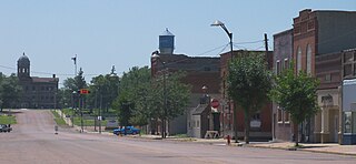
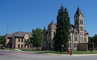
Parker is a city in Turner County, South Dakota, United States. The population was 1,194 at the 2020 census. It is the county seat of Turner County. Parker is bordered on its eastern side by South Dakota State Highway 19. Its northern side is bordered by South Dakota State Highway 44. Parker is located approximately 8 miles (13 km) northwest of Chancellor, 42 miles (68 km) east of Parkston and 41 miles (66 km) south of Madison.

<span class="mw-page-title-main">Sioux Falls, South Dakota metropolitan area</span> Metropolitan area in the United States

The Sioux Falls Metropolitan Statistical Area, as defined by the United States Census Bureau, is an area consisting of four counties in South Dakota and one county in Minnesota, anchored by the city of Sioux Falls. The metro area is referred to locally as the Sioux Empire. Despite the name, it is considered a part of the larger area known as Siouxland as it is within the Big Sioux River basin. As of the 2020 census, the MSA had a population of 276,730.

References

  1. 1 2 "State & County QuickFacts". United States Census Bureau. Retrieved March 20, 2024.
  2. "Find a County". National Association of Counties. Retrieved June 7, 2011.
  3. Hellmann, Paul T. (May 13, 2013). Historical Gazetteer of the United States. Routledge. p. 994. ISBN   978-1135948597 . Retrieved November 30, 2013.
  4. 1 2 3 4 Turner County SD Google Maps (accessed February 8, 2019)
  5. ""Find at Altitude" Google Maps (accessed February 8, 2019)". Archived from the original on May 21, 2019. Retrieved February 9, 2019.
  6. "2010 Census Gazetteer Files". United States Census Bureau. August 22, 2012. Retrieved March 28, 2015.
  7. "County Population Totals and Components of Change: 2020-2023" . Retrieved March 17, 2024.
  8. "U.S. Decennial Census". United States Census Bureau. Retrieved March 28, 2015.
  9. "Historical Census Browser". University of Virginia Library. Retrieved March 28, 2015.
  10. Forstall, Richard L., ed. (March 27, 1995). "Population of Counties by Decennial Census: 1900 to 1990". United States Census Bureau. Retrieved March 28, 2015.
  11. "Census 2000 PHC-T-4. Ranking Tables for Counties: 1990 and 2000" (PDF). United States Census Bureau. April 2, 2001. Archived (PDF) from the original on October 9, 2022. Retrieved March 28, 2015.
  12. "US Census Bureau, Table P16: Household Type". United States Census Bureau. Retrieved March 20, 2024.
  13. "Turner County Fair" . Retrieved January 23, 2008.
  14. Leip, David. "Atlas of US Presidential Elections". uselectionatlas.org. Retrieved April 15, 2018.
  15. "2020 CENSUS - SCHOOL DISTRICT REFERENCE MAP: Turner County, SD" (PDF). U.S. Census Bureau . Retrieved March 13, 2024. - Text list

43°19′N97°09′W / 43.31°N 97.15°W / 43.31; -97.15