Tripp County, South Dakota

Last updated

Tripp County
Tripp County, SD courthouse from S 1.JPG
Tripp County courthouse in Winner
Map of South Dakota highlighting Tripp County.svg
Location within the U.S. state of South Dakota
South Dakota in United States.svg
South Dakota's location within the U.S.
Coordinates: 43°20′N99°53′W / 43.34°N 99.88°W / 43.34; -99.88
CountryFlag of the United States.svg United States
StateFlag of South Dakota.svg  South Dakota
Founded1873 (created)
1909 (organized)
Named for Bartlett Tripp
Seat Winner
Largest cityWinner
Area
  Total1,618 sq mi (4,190 km2)
  Land1,612 sq mi (4,180 km2)
  Water5.1 sq mi (13 km2)  0.3%
Population
 (2020)
  Total5,624
  Estimate 
(2023)
5,621 Decrease2.svg
  Density3.5/sq mi (1.3/km2)
Time zone UTC−6 (Central)
  Summer (DST) UTC−5 (CDT)
Congressional district At-large
Website trippcounty.us

Tripp County is a county in the U.S. state of South Dakota. As of the 2020 census, the population was 5,624. [1] Its county seat is Winner. [2] The county was created in 1873, and was organized in 1909. [3] It is named for lawyer, judge, and diplomat Bartlett Tripp.

Contents

Geography

Tripp County lies on the south line of South Dakota. Its south boundary is the Nebraska state line, while its north boundary is the meandering White River. The Keya Paha River flows east-southeasterly through the lower part of the county. The county terrain is composed of rolling hills carved by gullies and drainages. [4] The county terrain generally slopes to the south and east, although its upper portion drops northward into the White River valley. The county's highest point is on the lower part of its west boundary line, at 2,552 ft (778 m) ASL. [5] The county has a total area of 1,618 square miles (4,190 km2), of which 1,612 square miles (4,180 km2) is land and 5.1 square miles (13 km2) (0.3%) is water. [6]

Major highways

Adjacent counties

Protected areas [4]

Lakes [4]

Demographics

Historical population
CensusPop.Note
1910 8,323
1920 11,97043.8%
1930 12,7126.2%
1940 9,937−21.8%
1950 9,139−8.0%
1960 8,761−4.1%
1970 8,171−6.7%
1980 7,268−11.1%
1990 6,924−4.7%
2000 6,430−7.1%
2010 5,644−12.2%
2020 5,624−0.4%
2023 (est.)5,621 [7] −0.1%
U.S. Decennial Census [8]
1790-1960 [9] 1900-1990 [10]
1990-2000 [11] 2010-2020 [1]

2020 census

As of the 2020 census, there were 5,624 people, 2,233 households, and 1,398 families residing in the county. [12] The population density was 3.5 inhabitants per square mile (1.4/km2). There were 2,762 housing units.

2010 census

As of the 2010 census, there were 5,644 people, 2,419 households, and 1,509 families in the county. The population density was 3.5 inhabitants per square mile (1.4/km2). There were 3,072 housing units at an average density of 1.9 per square mile (0.73/km2). The racial makeup of the county was 83.1% white, 14.0% American Indian, 0.2% Asian, 0.1% black or African American, 0.2% from other races, and 2.4% from two or more races. Those of Hispanic or Latino origin made up 1.1% of the population. In terms of ancestry, 46.8% were German, 10.8% were Irish, 7.7% were Czech, 6.2% were Dutch, and 4.0% were American.

Of the 2,419 households, 26.9% had children under the age of 18 living with them, 50.4% were married couples living together, 8.4% had a female householder with no husband present, 37.6% were non-families, and 34.6% of all households were made up of individuals. The average household size was 2.28 and the average family size was 2.93. The median age was 45.3 years.

The median income for a household in the county was $40,221 and the median income for a family was $49,570. Males had a median income of $35,238 versus $25,323 for females. The per capita income for the county was $21,192. About 12.1% of families and 16.5% of the population were below the poverty line, including 27.4% of those under age 18 and 10.3% of those age 65 or over.

Communities

City

Town [4]

Census-designated place

Unincorporated communities

Townships

  • Banner
  • Beaver Creek
  • Black
  • Brunson
  • Bull Creek
  • Carter
  • Colome
  • Condon
  • Curlew
  • Dog Ear
  • Elliston
  • Greenwood
  • Holsclaw
  • Huggins
  • Ideal
  • Irwin
  • Jordan
  • Keyapaha
  • King
  • Lake
  • Lamro
  • Lincoln
  • Lone Star
  • Lone Tree
  • McNeely
  • Millboro
  • Pahapesto
  • Plainview
  • Pleasant Valley
  • Pleasant View
  • Progressive
  • Rames
  • Rosedale
  • Roseland
  • Star Prairie
  • Star Valley
  • Stewart
  • Sully
  • Taylor
  • Valley
  • Weave
  • Willow Creek
  • Wilson
  • Witten
  • Wortman
  • Wright

Unorganized territory

The county contains one area of unorganized territory: Gassman.

Politics

Tripp County voters have traditionally voted Republican. In no national election since 1964 has the county selected the Democratic Party candidate (as of 2020). The Democratic Party has not obtained forty percent of the county's vote since Jimmy Carter in 1976.

United States presidential election results for Tripp County, South Dakota [13]
Year Republican Democratic Third party
No.%No.%No.%
2020 2,16180.16%49518.36%401.48%
2016 2,06978.67%46217.57%993.76%
2012 1,90570.79%73727.39%491.82%
2008 1,85965.48%91432.19%662.32%
2004 2,23068.72%97229.95%431.33%
2000 1,90969.04%79928.90%572.06%
1996 1,68053.64%1,08834.74%36411.62%
1992 1,45943.38%1,04631.10%85825.51%
1988 2,11362.96%1,21936.32%240.72%
1984 2,48372.18%93527.18%220.64%
1980 2,66970.68%94725.08%1604.24%
1976 1,98051.87%1,82247.73%150.39%
1972 2,59262.73%1,53837.22%20.05%
1968 2,24258.25%1,36235.39%2456.37%
1964 1,93746.36%2,24153.64%00.00%
1960 2,46658.52%1,74841.48%00.00%
1956 2,06452.94%1,83547.06%00.00%
1952 2,79065.88%1,44534.12%00.00%
1948 1,84548.32%1,91850.24%551.44%
1944 1,91153.82%1,64046.18%00.00%
1940 2,49254.40%2,08945.60%00.00%
1936 1,69337.75%2,70860.38%841.87%
1932 1,14723.67%3,64775.26%521.07%
1928 2,39653.02%2,09946.45%240.53%
1924 1,64742.45%93224.02%1,30133.53%
1920 1,81959.33%96831.57%2799.10%
1916 1,07443.57%1,34154.40%502.03%
1912 00.00%98243.66%1,26756.34%

See also

Related Research Articles

<span class="mw-page-title-main">Walworth County, South Dakota</span> County in South Dakota, United States

Walworth County is a county in the U.S. state of South Dakota. As of the 2020 census, the population was 5,315. Its county seat is Selby. The county was created in 1873 and organized in 1883. It is named for Walworth County, Wisconsin.

<span class="mw-page-title-main">Union County, South Dakota</span> County in South Dakota, United States

Union County is the southernmost county in the U.S. state of South Dakota. As of the 2020 census, the population was 16,811, making it the 13th most populous county in South Dakota. Its county seat has been Elk Point since April 30, 1865. Originally named Cole County, its name was changed to Union on January 7, 1864, because of Civil War sentiment.

<span class="mw-page-title-main">Sully County, South Dakota</span> County in South Dakota, United States

Sully County is a county in the U.S. state of South Dakota. As of the 2020 census, the population was 1,446, making it the fifth-least populous county in South Dakota. Its county seat is Onida. The county was created in 1873 and organized in 1883. It is named after General Alfred Sully, who built Fort Sully.

<span class="mw-page-title-main">Potter County, South Dakota</span> County in South Dakota, United States

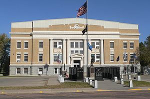
Potter County is a county in the U.S. state of South Dakota. As of the 2020 census, the population was 2,472. Its county seat is Gettysburg. The county was created in 1873 and organized in 1883.

<span class="mw-page-title-main">Moody County, South Dakota</span> County in South Dakota, United States

Moody County is a county in the U.S. state of South Dakota, United States. The population was 6,336 at the 2020 census. Its county seat is Flandreau. The county is named for Gideon C. Moody.

<span class="mw-page-title-main">Meade County, South Dakota</span> County in South Dakota, United States

Meade County is a county in the U.S. state of South Dakota. As of the 2020 census, the population was 29,852, making it the 6th most populous county in South Dakota. Its county seat is Sturgis. The county was created in 1889 and named for Fort Meade, which was garrisoned as a United States military post in the area in 1878 and itself named for General George Meade.

<span class="mw-page-title-main">McPherson County, South Dakota</span> County in South Dakota, United States

McPherson County is a county in the U.S. state of South Dakota. As of the 2020 census, the population was 2,411. Its county seat is Leola.

<span class="mw-page-title-main">McCook County, South Dakota</span> County in South Dakota, United States

McCook County is a county in the U.S. state of South Dakota. At the 2020 census, the population was 5,682. Its county seat is Salem. The county was established in 1873, and was organized in 1878. It was named for the former governor of the Dakota Territory and Civil War general Edwin Stanton McCook.

<span class="mw-page-title-main">Marshall County, South Dakota</span> County in South Dakota, United States

Marshall County is a county in the U.S. state of South Dakota. As of the 2020 census, the population was 4,306. Its county seat is Britton. The county was created on May 2, 1885, and was named for Marshall Vincent, who homesteaded near Andover, South Dakota.

<span class="mw-page-title-main">Lyman County, South Dakota</span> County in South Dakota, United States

Lyman County is a county located in the U.S. state of South Dakota. As of the 2020 census, the population was 3,718. Its county seat is Kennebec.

<span class="mw-page-title-main">Hyde County, South Dakota</span> County in South Dakota, United States

Hyde County is a county in the U.S. state of South Dakota. As of the 2020 census, the population was 1,262, making it the second-least populous county in South Dakota. Its county seat is Highmore. The county was founded in 1873, as a county of the Dakota Territory, and organized in 1883. It was named for James Hyde, a member of legislature in the 1870s.

<span class="mw-page-title-main">Hughes County, South Dakota</span> County in South Dakota, United States

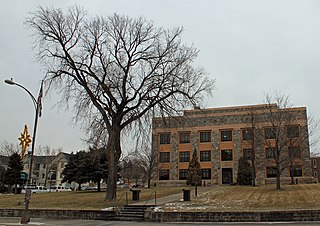
Hughes County is a county in the U.S. state of South Dakota. As of the 2020 census, the population was 17,765, making it the least populous capital county in the nation, and the 12th most populous county in South Dakota. Its county seat is Pierre, which is also the state capital. The county was created in 1873, and was organized in 1880. It was named for Alexander Hughes, a legislator. On June 4, 1891, the county's area was increased by the addition of Farm Island, in the Missouri River downstream of Pierre.

<span class="mw-page-title-main">Hand County, South Dakota</span> County in South Dakota, United States

Hand County is a county in the U.S. state of South Dakota. As of the 2020 census, the population was 3,145. Its county seat is Miller.

<span class="mw-page-title-main">Gregory County, South Dakota</span> County in South Dakota, United States

Gregory County is a county in the U.S. state of South Dakota. As of the 2020 census, the population was 3,994. Its county seat is Burke. The county was created in 1862 and organized in 1898. It was named for the politician J. Shaw Gregory.

<span class="mw-page-title-main">Faulk County, South Dakota</span> County in South Dakota, United States

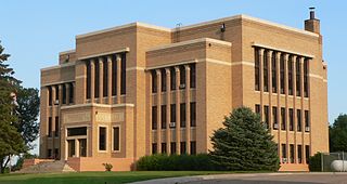
Faulk County is a county in the U.S. state of South Dakota. As of the 2020 census, the population was 2,125. Its county seat is Faulkton. The county was founded in 1873 and organized in 1883. It is named for Andrew Jackson Faulk, the third Governor of Dakota Territory.

<span class="mw-page-title-main">Edmunds County, South Dakota</span> County in South Dakota, United States

Edmunds County is a county in the U.S. state of South Dakota. At the 2020 census, the population was 3,986. Its county seat is Ipswich. The county was established in 1873 and organized in 1883. It is named for Newton Edmunds, the second Governor of Dakota Territory.

<span class="mw-page-title-main">Charles Mix County, South Dakota</span> County in South Dakota, United States

Charles Mix County is a county in the U.S. state of South Dakota. As of the 2020 census, the population was 9,373. Its county seat is Lake Andes. The county was created in 1862 and organized in 1879. It was named for Charles Eli Mix, an official of the Bureau of Indian Affairs influential in signing a peace treaty with the local Lakota Indian tribes. The easternmost approximately 60% of the county comprises the Yankton Indian Reservation.

<span class="mw-page-title-main">Brookings County, South Dakota</span> County in South Dakota, United States

Brookings County is a county in the U.S. state of South Dakota. As of the 2020 census, the population was 34,375, making it the fifth most populous county in South Dakota. Its county seat is Brookings. The county was created in 1862 and organized in 1871.

<span class="mw-page-title-main">Beadle County, South Dakota</span> County in South Dakota, United States

Beadle County is a county in the U.S. state of South Dakota. As of the 2020 census, the population was 19,149, making it the 11th most populous county in South Dakota. Its county seat is Huron. The county was created in 1879 and organized in 1880. Beadle County comprises the Huron, SD Micropolitan Statistical Area.

<span class="mw-page-title-main">Cherry County, Nebraska</span> County in Nebraska, United States

Cherry County is a county located in the U.S. state of Nebraska. As of the 2020 United States Census, the population was 5,455. Its county seat is Valentine. The county was named for Lt. Samuel A. Cherry, an Army officer who was stationed at Fort Niobrara and who had been killed in South Dakota in 1881. Cherry County is in the Nebraska Sandhills. It is the largest county in the state at nearly 6,000 square miles (16,000 km2), larger than the state of Connecticut.

References

  1. 1 2 "State & County QuickFacts". United States Census Bureau. Retrieved March 20, 2024.
  2. "Find a County". National Association of Counties. Retrieved June 7, 2011.
  3. "Dakota Territory, South Dakota, and North Dakota: Individual County Chronologies". Dakota Territory Atlas of Historical County Boundaries. The Newberry Library. 2006. Archived from the original on April 2, 2018. Retrieved March 31, 2015.
  4. 1 2 3 4 "Tripp County · South Dakota". Google Maps. Retrieved April 27, 2024.
  5. ""Find an Altitude" Google Maps (accessed February 8, 2019)". Archived from the original on May 21, 2019. Retrieved February 9, 2019.
  6. "2010 Census Gazetteer Files". United States Census Bureau. August 22, 2012. Retrieved March 28, 2015.
  7. "County Population Totals and Components of Change: 2020-2023" . Retrieved March 17, 2024.
  8. "U.S. Decennial Census". United States Census Bureau. Retrieved March 28, 2015.
  9. "Historical Census Browser". University of Virginia Library. Retrieved March 28, 2015.
  10. Forstall, Richard L., ed. (March 27, 1995). "Population of Counties by Decennial Census: 1900 to 1990". United States Census Bureau. Retrieved March 28, 2015.
  11. "Census 2000 PHC-T-4. Ranking Tables for Counties: 1990 and 2000" (PDF). United States Census Bureau. April 2, 2001. Archived (PDF) from the original on October 9, 2022. Retrieved March 28, 2015.
  12. "US Census Bureau, Table P16: Household Type". United States Census Bureau. Retrieved March 20, 2024.
  13. Leip, David. "Atlas of US Presidential Elections". uselectionatlas.org. Retrieved April 15, 2018.

43°20′N99°53′W / 43.34°N 99.88°W / 43.34; -99.88