Sisseton, South Dakota

Last updated

Sisseton
Welcometosisseton.JPG
Welcome to Sisseton
Roberts County South Dakota Incorporated and Unincorporated areas Sisseton Highlighted.svg
Location in Roberts County and the state of South Dakota
Coordinates: 45°39′45″N97°02′43″W / 45.66250°N 97.04528°W / 45.66250; -97.04528
CountryUnited States
State South Dakota
County Roberts
FoundedAugust 1, 1864
Incorporated August 17, 1907 [1]
Government
   Mayor Terry Jaspers
Area
[2]
  Total1.59 sq mi (4.12 km2)
  Land1.59 sq mi (4.12 km2)
  Water0.00 sq mi (0.00 km2)
Elevation
[3]
1,234 ft (376 m)
Population
 (2020) [4]
  Total2,479
  Estimate 
(2022) [5]
2,412
  Density1,558.14/sq mi (601.52/km2)
Time zone UTC–6 (Central (CST))
  Summer (DST) UTC–5 (CDT)
ZIP code
57262
Area code 605
FIPS code 46-59260
GNIS feature ID1267567 [3]
Sales tax 6.2%
Website sisseton.com

Sisseton is a city in Roberts County, South Dakota, United States. The population was 2,479 at the 2020 census. [4] It is the county seat of Roberts County. [6] Sisseton is the home to a number of tourist attractions, including the Nicollet Tower, and is near the "Song to the Great Spirit" building on the Sisseton Wahpeton College campus. The city is named for the Sisseton (or Sissetowan) division of the Native American Sioux. [7] It also serves as an important part of the Lake Traverse Indian Reservation. [8]

Contents

Geography

According to the United States Census Bureau, the city has a total area of 1.59 square miles (4.12 km2), all land. [9]

Climate

Climate data for Sisseton Municipal Airport, South Dakota (1991−2020 normals, extremes 1931−present [lower-alpha 1] )
MonthJanFebMarAprMayJunJulAugSepOctNovDecYear
Record high °F (°C)65
(18)
68
(20)
82
(28)
99
(37)
113
(45)
105
(41)
113
(45)
108
(42)
102
(39)
95
(35)
79
(26)
70
(21)
113
(45)
Mean daily maximum °F (°C)22.6
(−5.2)
27.0
(−2.8)
39.5
(4.2)
55.0
(12.8)
69.2
(20.7)
78.4
(25.8)
83.1
(28.4)
80.9
(27.2)
73.5
(23.1)
58.0
(14.4)
41.5
(5.3)
27.8
(−2.3)
54.7
(12.6)
Daily mean °F (°C)13.3
(−10.4)
17.6
(−8.0)
29.9
(−1.2)
43.8
(6.6)
57.3
(14.1)
67.2
(19.6)
71.4
(21.9)
68.9
(20.5)
60.8
(16.0)
46.8
(8.2)
31.9
(−0.1)
19.1
(−7.2)
44.0
(6.7)
Mean daily minimum °F (°C)4.1
(−15.5)
8.2
(−13.2)
20.4
(−6.4)
32.5
(0.3)
45.3
(7.4)
56.0
(13.3)
59.8
(15.4)
56.9
(13.8)
48.0
(8.9)
35.5
(1.9)
22.4
(−5.3)
10.4
(−12.0)
33.3
(0.7)
Record low °F (°C)−37
(−38)
−33
(−36)
−29
(−34)
−3
(−19)
19
(−7)
32
(0)
40
(4)
35
(2)
22
(−6)
4
(−16)
−18
(−28)
−30
(−34)
−37
(−38)
Average precipitation inches (mm)0.63
(16)
0.70
(18)
1.11
(28)
2.09
(53)
2.79
(71)
3.50
(89)
3.49
(89)
2.61
(66)
2.45
(62)
2.33
(59)
0.64
(16)
0.60
(15)
22.94
(583)
Average snowfall inches (cm)6.2
(16)
7.3
(19)
6.1
(15)
5.6
(14)
0.0
(0.0)
0.0
(0.0)
0.0
(0.0)
0.0
(0.0)
0.0
(0.0)
1.0
(2.5)
4.6
(12)
5.5
(14)
36.3
(92)
Average precipitation days (≥ 0.01 in)8.88.08.09.110.912.110.59.68.48.95.78.3108.3
Average snowy days (≥ 0.1 in)5.65.33.31.90.00.00.00.00.00.72.44.623.8
Source: NOAA [11] [12]
Notes
  1. Records maintained at the airport since August 27, 1998, and at the Sisseton COOP before that. [10]

Demographics

Historical population
CensusPop.Note
1900 928
1910 1,39750.5%
1920 1,4312.4%
1930 1,5699.6%
1940 2,51360.2%
1950 2,87114.2%
1960 3,21812.1%
1970 3,094−3.9%
1980 2,789−9.9%
1990 2,181−21.8%
2000 2,57217.9%
2010 2,470−4.0%
2020 2,4790.4%
2022 (est.)2,412 [5] −2.7%
U.S. Decennial Census [13]
2020 Census [4]

2010 census

As of the census of 2010, there were 2,470 people, 958 households, and 576 families living in the city. The population density was 1,553.5 inhabitants per square mile (599.8/km2). There were 1,057 housing units at an average density of 664.8 per square mile (256.7/km2). The racial makeup of the city was 47.0% White, 0.1% African American, 47.8% Native American, 0.4% Asian, 0.2% from other races, and 4.5% from two or more races. Hispanic or Latino of any race were 1.6% of the population.

There were 958 households, of which 36.3% had children under the age of 18 living with them, 34.2% were married couples living together, 17.1% had a female householder with no husband present, 8.8% had a male householder with no wife present, and 39.9% were non-families. 34.9% of all households were made up of individuals, and 16.3% had someone living alone who was 65 years of age or older. The average household size was 2.48 and the average family size was 3.22.

The median age in the city was 34.6 years. 29.7% of residents were under the age of 18; 9% were between the ages of 18 and 24; 22.1% were from 25 to 44; 21.9% were from 45 to 64; and 17.4% were 65 years of age or older. The gender makeup of the city was 48.1% male and 51.9% female.

2000 census

As of the census of 2000, there were 2,572 people, 1,003 households, and 631 families living in the city. The population density was 1,636.7 inhabitants per square mile (631.9/km2). There were 1,093 housing units at an average density of 695.5 per square mile (268.5/km2). The racial makeup of the city was 56.07% White, 0.12% African American, 40.86% Native American, 0.27% Asian, 0.04% from other races, and 2.64% from two or more races. Hispanic or Latino of any race were 1.09% of the population.

There were 1,003 households, out of which 31.9% had children under the age of 18 living with them, 38.9% were married couples living together, 16.9% had a female householder with no husband present, and 37.0% were non-families. 34.6% of all households were made up of individuals, and 16.2% had someone living alone who was 65 years of age or older. The average household size was 2.46 and the average family size was 3.12.

In the city, the population was spread out, with 29.3% under the age of 18, 8.2% from 18 to 24, 23.3% from 25 to 44, 20.8% from 45 to 64, and 18.4% who were 65 years of age or older. The median age was 36 years. For every 100 females, there were 88.8 males. For every 100 females age 18 and over, there were 86.2 males.

As of 2000 the median income for a household in the city was $26,698, and the median income for a family was $33,977. Males had a median income of $27,393 versus $20,586 for females. The per capita income for the city was $14,019. About 14.9% of families and 18.4% of the population were below the poverty line, including 23.6% of those under age 18 and 16.4% of those age 65 or over.

Education

Sisseton Wahpeton College, a small college that is part of Sisseton Wahpeton Oyate, is near Sisseton in Agency Village. The college offers undergraduate and vocational degrees. About 80% of the college's 250 students are Dakota people.

Sisseton School District 54-9 has four schools: Sisseton High School, Sisseton Middle School, New Effington Elementary and Westside Elementary. [14]

Tiospa Zina Tribal School, a tribal K-12 school in Agency Village, [15] is 6 miles (9.7 km) from Sisseton. [16] it is Bureau of Indian Education (BIE)-affiliated.

Media

FM radio

FM radio stations
FrequencyCall signNameFormatOwnerTarget city/market City of license
89.9 FMKXSW Country/Rock Corporation for Native BroadcastingSissetonSisseton
99.5 FM KJKQ Jack FM Adult Hits Armada MediaSissetonSisseton
102.9 FM KBWS-FM Pheasant Country 103 Country Armada MediaSissetonSisseton

Transportation

Intercity bus service to the city is provided by Jefferson Lines. [17]

Notable people

Related Research Articles

<span class="mw-page-title-main">Wahpeton, Iowa</span> City in Iowa, United States

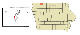
Wahpeton is a city in Dickinson County, Iowa, United States. The population was 345 at the time of the 2020 census.

<span class="mw-page-title-main">Breckenridge, Minnesota</span> City in Minnesota, United States

Breckenridge is a city and county seat of Wilkin County, Minnesota, United States. The population was 3,430 at the 2020 census.

<span class="mw-page-title-main">Devils Lake, North Dakota</span> City in North Dakota, United States

Devils Lake is a city in and the county seat of Ramsey County, North Dakota, United States. The population was 7,192 at the 2020 census. It is named after the nearby body of water called Devils Lake. The first house built by an Euro-American settler was in 1882. It was surveyed in 1883 and named Creelsburg and later Creel City, after the surveyor, Heber M. Creel. In 1884 it was renamed Devils Lake.

<span class="mw-page-title-main">Barney, North Dakota</span> City in North Dakota, United States

Barney is a city in Richland County, North Dakota, United States. The population was 40 at the 2020 census. Barney was founded in 1899. It is part of the Wahpeton, ND–MN Micropolitan Statistical Area.

<span class="mw-page-title-main">Colfax, North Dakota</span> City in North Dakota, United States

Colfax is a city in Richland County, North Dakota, United States. The population was 172 at the 2020 census. Colfax was founded in 1881. It is part of the Wahpeton, ND–MN Micropolitan Statistical Area. In the mid-1960s it billed itself as the "smallest town in the U.S. with a public swimming pool".

<span class="mw-page-title-main">Dwight, North Dakota</span> City in North Dakota, United States

Dwight is a city in Richland County, North Dakota, United States. The population was 80 at the 2020 census. Dwight was founded in 1881. It is part of the Wahpeton, ND–MN Micropolitan Statistical Area.

<span class="mw-page-title-main">Fairmount, North Dakota</span> City in Richland County, North Dakota, United States

Fairmount is a city in Richland County, North Dakota, United States. The population was 343 at the 2020 census. Fairmount was founded in 1884. It is part of the Wahpeton, ND–MN Micropolitan Statistical Area.

<span class="mw-page-title-main">Great Bend, North Dakota</span> City in North Dakota, United States

Great Bend is a city in Richland County, North Dakota, United States, on the banks of the Wild Rice River. Its population was 49 at the 2020 census. It was founded in 1888, and incorporated as a village in 1908. It is part of the Wahpeton, ND–MN Micropolitan Statistical Area.

<span class="mw-page-title-main">Hankinson, North Dakota</span> City in North Dakota, United States

Hankinson is a city in Richland County, North Dakota, United States. The population was 921 at the 2020 census. Hankinson was founded in 1886. It is part of the Wahpeton, ND–MN Micropolitan Statistical Area.

<span class="mw-page-title-main">Lidgerwood, North Dakota</span> City in North Dakota, United States

Lidgerwood is a city in Richland County, North Dakota, United States. The population was 600 at the 2020 census. Lidgerwood was founded in 1886. It is part of the Wahpeton, ND–MN Micropolitan Statistical Area.

<span class="mw-page-title-main">Mantador, North Dakota</span> City in North Dakota, United States

Mantador is a city in Richland County, North Dakota, United States. The population was 67 at the 2020 census. Mantador was founded in 1893. It is part of the Wahpeton, ND-MN Micropolitan Statistical Area.

<span class="mw-page-title-main">Mooreton, North Dakota</span> City in North Dakota, United States

Mooreton is a city in Richland County, North Dakota, United States. The population was 177 at the 2020 census. Mooreton was founded in 1884. It is part of the Wahpeton, ND–MN Micropolitan Statistical Area.

<span class="mw-page-title-main">Wahpeton, North Dakota</span> City in North Dakota, United States

Wahpeton is a city in Richland County, in southeast North Dakota along the Bois de Sioux River at its confluence with the Otter Tail River, which forms the Red River of the North. Wahpeton is the county seat of Richland County. The population was 8,007 at the 2020 census.

<span class="mw-page-title-main">Walcott, North Dakota</span> City in North Dakota, United States

Walcott is a city in Richland County, North Dakota, United States. The population was 262 at the 2020 census. Walcott was founded in 1880. It is part of the Wahpeton, ND–MN Micropolitan Statistical Area.

<span class="mw-page-title-main">Wyndmere, North Dakota</span> City in North Dakota, United States

Wyndmere is a city in Richland County, North Dakota, United States. The population was 454 at the 2020 census. Wyndmere was founded in 1883 and named after Windermere in England. It is part of the Wahpeton, ND–MN Micropolitan Statistical Area.

<span class="mw-page-title-main">Hoople, North Dakota</span> City in North Dakota, United States

Hoople is a city in Walsh County, North Dakota, United States. The population was 247 at the 2020 census. Hoople, named for early settler Alan Hoople, was founded in 1889. Hoople's nickname is "Tatertown."

<span class="mw-page-title-main">Lake Andes, South Dakota</span> City in South Dakota, United States

Lake Andes is a city in, and the county seat of, Charles Mix County, South Dakota, United States. The population was 710 at the 2020 census.

<span class="mw-page-title-main">Marty, South Dakota</span> CDP in South Dakota, United States

Marty is a census-designated place (CDP) in southern Charles Mix County, South Dakota, United States. The population was 677 at the 2020 census.

<span class="mw-page-title-main">Lake City, South Dakota</span> Town in South Dakota, United States

Lake City is a town in Marshall County, South Dakota, United States. The population was 45 at the 2020 census. Fort Sisseton Historic State Park, whose fort is listed on the National Register of Historic Places, is located nearby.

<span class="mw-page-title-main">Box Elder, South Dakota</span> City in South Dakota, United States

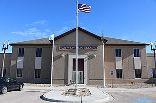
Box Elder is a city in Pennington and Meade counties in the State of South Dakota. The population was 11,746 at the 2020 census, making it the 11th most populous city in South Dakota. Ellsworth Air Force Base lies on the northeast side of the city.

References

  1. "SD Towns" (PDF). South Dakota State Historical Society . Retrieved February 15, 2010.
  2. "2020 U.S. Gazetteer Files". United States Census Bureau. Retrieved July 24, 2022.
  3. 1 2 U.S. Geological Survey Geographic Names Information System: Sisseton, South Dakota
  4. 1 2 3 "Explore Census Data". United States Census Bureau . Retrieved January 7, 2024.
  5. 1 2 "City and Town Population Totals: 2020-2022". United States Census Bureau. January 7, 2024. Retrieved January 7, 2024.
  6. "Find a County". National Association of Counties. Retrieved June 7, 2011.
  7. Federal Writers' Project (1940). South Dakota place-names, v.1-3. American guide series. University of South Dakota. p. 61.
  8. "South Dakota: Sisseton Reservation (Lake Traverse) - American Indian Relief Council is now Northern Plains Reservation Aid". www.nativepartnership.org.
  9. "US Gazetteer files 2010". United States Census Bureau. Archived from the original on January 25, 2012. Retrieved June 21, 2012.
  10. "Threaded Extremes". threadex.rcc-acis.org.
  11. "NowData - NOAA Online Weather Data". National Oceanic and Atmospheric Administration. Retrieved October 13, 2021.
  12. "Station: Sisseton Muni AP, SD". U.S. Climate Normals 2020: U.S. Monthly Climate Normals (1991-2020). National Oceanic and Atmospheric Administration. Retrieved October 13, 2021.
  13. "Census of Population and Housing". United States Census Bureau. Retrieved July 20, 2014.
  14. "Search for Public School Districts – District Detail for Sisseton School District 54-2". National Center for Education Statistics . Institute of Education Sciences . Retrieved February 7, 2015.
  15. "Tiospa Zina Tribal School". National Center for Education Statistics . Retrieved February 27, 2023.
  16. Haugen, Doris (December 31, 1994). "Indian community plans school honoring culture". Associated Press. p. B3. - Clipping from Newspapers.com.
  17. "South Dakota Bus Stops" . Retrieved July 20, 2023.