Dupree, South Dakota | |
---|---|
Coordinates: 45°02′58″N101°36′05″W / 45.04944°N 101.60139°W | |
Country | United States |
State | South Dakota |
County | Ziebach |
Incorporated | 1911 [1] |
Government | |
• Mayor | Don Howe [2] |
Area | |
• Total | 0.39 sq mi (1.02 km2) |
• Land | 0.39 sq mi (1.02 km2) |
• Water | 0.00 sq mi (0.00 km2) |
Elevation | 2,369 ft (722 m) |
Population | |
• Total | 494 |
• Density | 1,260.20/sq mi (486.67/km2) |
Time zone | UTC-7 (Mountain (MST)) |
• Summer (DST) | UTC-6 (MDT) |
ZIP code | 57623 |
Area code | 605 |
FIPS code | 46-17420 [6] |
GNIS feature ID | 1267359 [4] |
Dupree is a city in and county seat of Ziebach County, South Dakota, United States. The population was 494 at the 2020 census. [7] It is the only incorporated community located fully within Ziebach County.
Dupree got its start in 1910, following construction of the Milwaukee Railroad through the territory. [8] The city derives its name from Fred Dupris, a pioneer settler. [8]
According to the United States Census Bureau, the city has a total area of 0.39 square miles (1.01 km2), all land. [9]
Climate data for Dupree, South Dakota (1991–2020 normals, extremes 1922–present) | |||||||||||||
---|---|---|---|---|---|---|---|---|---|---|---|---|---|
Month | Jan | Feb | Mar | Apr | May | Jun | Jul | Aug | Sep | Oct | Nov | Dec | Year |
Record high °F (°C) | 68 (20) | 72 (22) | 83 (28) | 96 (36) | 107 (42) | 110 (43) | 114 (46) | 110 (43) | 107 (42) | 97 (36) | 79 (26) | 71 (22) | 114 (46) |
Mean maximum °F (°C) | 52.0 (11.1) | 55.8 (13.2) | 70.1 (21.2) | 81.2 (27.3) | 87.8 (31.0) | 94.7 (34.8) | 100.9 (38.3) | 100.5 (38.1) | 96.0 (35.6) | 84.4 (29.1) | 67.1 (19.5) | 53.9 (12.2) | 102.7 (39.3) |
Average high °F (°C) | 31.4 (−0.3) | 35.1 (1.7) | 47.9 (8.8) | 60.7 (15.9) | 71.7 (22.1) | 82.3 (27.9) | 90.2 (32.3) | 89.5 (31.9) | 80.0 (26.7) | 62.6 (17.0) | 46.2 (7.9) | 34.2 (1.2) | 61.0 (16.1) |
Daily mean °F (°C) | 20.6 (−6.3) | 24.1 (−4.4) | 35.2 (1.8) | 46.8 (8.2) | 57.9 (14.4) | 68.3 (20.2) | 75.2 (24.0) | 73.9 (23.3) | 64.4 (18.0) | 49.1 (9.5) | 34.6 (1.4) | 23.7 (−4.6) | 47.8 (8.8) |
Average low °F (°C) | 9.8 (−12.3) | 13.1 (−10.5) | 22.5 (−5.3) | 32.9 (0.5) | 44.0 (6.7) | 54.3 (12.4) | 60.2 (15.7) | 58.3 (14.6) | 48.8 (9.3) | 35.6 (2.0) | 23.1 (−4.9) | 13.3 (−10.4) | 34.7 (1.5) |
Mean minimum °F (°C) | −16.8 (−27.1) | −10.7 (−23.7) | −1.7 (−18.7) | 14.0 (−10.0) | 27.5 (−2.5) | 41.2 (5.1) | 48.0 (8.9) | 44.6 (7.0) | 31.5 (−0.3) | 15.6 (−9.1) | 2.2 (−16.6) | −10.4 (−23.6) | −22.1 (−30.1) |
Record low °F (°C) | −39 (−39) | −35 (−37) | −31 (−35) | −7 (−22) | 18 (−8) | 31 (−1) | 38 (3) | 34 (1) | 8 (−13) | −11 (−24) | −22 (−30) | −34 (−37) | −39 (−39) |
Average precipitation inches (mm) | 0.41 (10) | 0.59 (15) | 0.85 (22) | 1.98 (50) | 3.27 (83) | 3.72 (94) | 2.49 (63) | 1.79 (45) | 1.22 (31) | 1.60 (41) | 0.43 (11) | 0.50 (13) | 18.85 (479) |
Average snowfall inches (cm) | 5.4 (14) | 8.2 (21) | 6.0 (15) | 6.8 (17) | 0.5 (1.3) | 0.0 (0.0) | 0.0 (0.0) | 0.0 (0.0) | 0.0 (0.0) | 2.3 (5.8) | 3.4 (8.6) | 8.1 (21) | 40.7 (103) |
Average precipitation days (≥ 0.01 in) | 3.7 | 4.0 | 4.4 | 7.2 | 9.2 | 9.7 | 7.6 | 6.1 | 4.6 | 5.3 | 3.6 | 3.8 | 69.2 |
Average snowy days (≥ 0.1 in) | 3.4 | 3.3 | 2.5 | 1.6 | 0.2 | 0.0 | 0.0 | 0.0 | 0.0 | 0.8 | 2.4 | 3.1 | 17.3 |
Source: NOAA [10] [11] |
Census | Pop. | Note | %± |
---|---|---|---|
1920 | 213 | — | |
1930 | 365 | 71.4% | |
1940 | 460 | 26.0% | |
1950 | 438 | −4.8% | |
1960 | 548 | 25.1% | |
1970 | 523 | −4.6% | |
1980 | 562 | 7.5% | |
1990 | 484 | −13.9% | |
2000 | 434 | −10.3% | |
2010 | 525 | 21.0% | |
2020 | 494 | −5.9% | |
U.S. Decennial Census [12] 2018 Estimate [13] [5] |
As of the census [14] of 2010, there were 525 people, 176 households, and 116 families residing in the city. The population density was 1,346.2 inhabitants per square mile (519.8/km2). There were 203 housing units at an average density of 520.5 per square mile (201.0/km2). The racial makeup of the city was 29.3% White, 66.9% Native American, 0.4% from other races, and 3.4% from two or more races. Hispanic or Latino of any race were 4.2% of the population.
There were 176 households, of which 44.9% had children under the age of 18 living with them, 38.1% were married couples living together, 21.6% had a female householder with no husband present, 6.3% had a male householder with no wife present, and 34.1% were non-families. 31.8% of all households were made up of individuals, and 10.8% had someone living alone who was 65 years of age or older. The average household size was 2.98 and the average family size was 3.83.
The median age in the city was 27.6 years. 37.3% of residents were under the age of 18; 9% were between the ages of 18 and 24; 22% were from 25 to 44; 23.8% were from 45 to 64; and 7.8% were 65 years of age or older. The gender makeup of the city was 46.5% male and 53.5% female.
As of the census [6] of 2000, there were 434 people, 146 households, and 108 families residing in the city. The population density was 1,089.8 inhabitants per square mile (420.8/km2). There were 171 housing units at an average density of 429.4 per square mile (165.8/km2). The racial makeup of the city was 28.11% White, 70.74% Native American, and 1.15% from two or more races. Hispanic or Latino of any race were 0.92% of the population.
There were 146 households, out of which 39.0% had children under the age of 18 living with them, 39.7% were married couples living together, 26.0% had a female householder with no husband present, and 26.0% were non-families. 24.0% of all households were made up of individuals, and 6.2% had someone living alone who was 65 years of age or older. The average household size was 2.97 and the average family size was 3.48.
In the city, the population was spread out, with 37.1% under the age of 18, 9.4% from 18 to 24, 24.7% from 25 to 44, 20.0% from 45 to 64, and 8.8% who were 65 years of age or older. The median age was 28 years. For every 100 females, there were 80.8 males. For every 100 females age 18 and over, there were 79.6 males.
The median income for a household in the city was $22,250, and the median income for a family was $20,781. Males had a median income of $21,667 versus $14,875 for females. The per capita income for the city was $8,206. About 41.9% of families and 52.1% of the population were below the poverty line, including 77.4% of those under age 18 and 17.0% of those age 65 or over.
Ziebach County is a county in the U.S. state of South Dakota. As of the 2020 census, the population was 2,413. Its county seat is Dupree. It is the last county in the United States alphabetically.
Fairmount is a city in Richland County, North Dakota, United States. The population was 343 at the 2020 census. Fairmount was founded in 1884. It is part of the Wahpeton, ND–MN Micropolitan Statistical Area.
Plankinton is a city in and county seat of Aurora County, South Dakota, United States. The population was 781 at the 2020 census.
Wagner is a city in Charles Mix County, South Dakota, United States. The population was 1,490 at the 2020 census. The city is served by Wagner Municipal Airport as well as YST Transit buses.
Bristol is a city located in western Day County, South Dakota, United States. It lies in Section 25 of Bristol Township, on the main line of what is now the BNSF Railway alongside U.S. Route 12. The population was 288 at the 2020 census.`
Clear Lake is a city in and the county seat of Deuel County, South Dakota, United States. The population was 1,218 at the 2020 census.
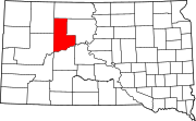
North Eagle Butte is a census-designated place (CDP) in Dewey County, South Dakota, United States, along the 45th parallel. The population was 1,879 at the 2020 census.
Gregory is a city in western Gregory County, South Dakota, United States. The population was 1,221 at the 2020 census.
Parkston is a city in Hutchinson County, South Dakota, United States. The population was 1,567 at the 2020 census.
Kadoka is a city in, and the county seat of, Jackson County, South Dakota, United States. The population was 543 at the 2020 census. The town occupies about 2.3 square miles.
Oldham is a city in Kingsbury County, South Dakota, United States. The population was 133 at the 2010 census.
Tea is a city in Lincoln County, South Dakota, United States and is a suburb of Sioux Falls. The population was 5,598 at the 2020 census.
Presho is a small city in Lyman County, South Dakota, United States. The population was 472 at the 2020 census.
Crooks is a city in Minnehaha County, South Dakota, United States and is a suburb of Sioux Falls. The population was 1,362 at the 2020 census. Crooks was named New Hope until 1904. The town's present name honors W. A. Crooks, a local politician.
Garretson is a city in Minnehaha County, South Dakota, United States. The city had a population of 1,228 at the 2020 census.
Hartford is a suburban American city in Minnehaha County, South Dakota, a few miles northwest of Sioux Falls. Its population was 3,354 at the 2020 census.
Doland is a city in eastern Spink County, South Dakota, United States. The population was 199 at the 2020 census.
Mellette is a city in Spink County, South Dakota, United States. The population was 199 at the 2020 census.
Iroquois is a city on the border of Beadle and Kingsbury counties in South Dakota, United States. The population was 292 at the 2020 census. The school building is located in Kingsbury County, while the school parking lot is located in Beadle County. Highway 14 runs directly through Iroquois.
Eagle Butte is a city in Dewey and Ziebach counties in South Dakota, United States. The population was 1,258 at the 2020 census.
Media related to Dupree, South Dakota at Wikimedia Commons