Huron, South Dakota

Last updated

Huron, South Dakota
Huron, SD, large pheasant from NE 1.jpg
World's Largest Pheasant in Huron
Beadle County South Dakota Incorporated and Unincorporated areas Huron Highlighted.svg
Location in Beadle County and the state of South Dakota
Usa edcp location map.svg
Red pog.svg
Huron, South Dakota
Location in the United States
Coordinates: 44°21′33″N98°13′5″W / 44.35917°N 98.21806°W / 44.35917; -98.21806
CountryUnited States
State South Dakota
County Beadle
Incorporated1883 [1]
Named for Huron Indians [1]
Government
  Type Commissioner Form
   Mayor Gary Harrington (D)
Area
[2]
  Total10.81 sq mi (27.99 km2)
  Land9.72 sq mi (25.17 km2)
  Water1.09 sq mi (2.82 km2)
Elevation
1,280 ft (390 m)
Population
 (2020) [3]
  Total14,263
  Density1,467.54/sq mi (566.64/km2)
Time zone UTC−6 (CST)
  Summer (DST) UTC−5 (CDT)
ZIP code
57350 and 57399
Area code 605
FIPS code 46-31060 [4]
GNIS feature ID1255722 [5]
Airport codeHON
Website huronsd.com

Huron is a city in and the county seat of Beadle County, South Dakota, United States. [6] The population was 14,263 at the 2020 census, [7] and it is the 8th most populous city in South Dakota.

Contents

The first settlement at Huron was made in 1880. [8] Huron is location of the South Dakota State Fair, and of a statue called the World's Largest Pheasant. [9]

History

Huron (left) and Pierre (right) issued rival maps that claimed each as the best place voters should choose for the new state capital in 1890. South Dakota capital rival 1889 maps.jpg
Huron (left) and Pierre (right) issued rival maps that claimed each as the best place voters should choose for the new state capital in 1890.

Huron was founded during railroad and land booms in the 1880s. The early history of the town is closely linked with the Chicago and Northwestern Railway. At the direction of Marvin Hughitt, general manager of the railroad, the west bank of the James River was selected as the railway's division headquarters. The company gained title to 880 acres (3.6 km2) of land at that location. Huron was named for the Huron Indians. [10]

The original plat covered 11 blocks, and Huron's first settler was John Cain, a practical printer from Troy, New York. He learned in Chicago, from the railroad people, that they would have their chief town and operating headquarters at their James River crossing.[ citation needed ]

Beginning in 1880, Huron and Pierre vied to be selected as the state capital, until Pierre was chosen in 1904. Campbell Park and Winter Park in Huron were previously designated as properties for the capital grounds, and a city block of land between the parks with Victorian houses was originally slated for the capitol building. [11]

Geography

According to the United States Census Bureau, the city has a total area of 10.57 square miles (27.38 km2), of which 9.48 square miles (24.55 km2) is land and 1.09 square miles (2.82 km2) is water. [12]

Climate

Huron has a humid continental climate, with hot, humid summers, cold, dry winters, and wide temperature extremes; it is part of USDA hardiness zone 4b. [13] The normal monthly mean temperature ranges from 16.0 °F (−8.9 °C) in January to 73.7 °F (23.2 °C) in July. [14] On average, there are 1.7 days that reach 100 °F (38 °C) or higher, 21.9 days that reach 90 °F (32 °C) or higher, 66.7 days that do not climb above freezing, 27.7 days with a low of 0 °F (−18 °C) or below, and 3.1 days that do not rise above 0 °F (−18 °C) annually. [14] [15] The average window for freezing temperatures are September 30 through May 5, [14] allowing a growing season of 147 days. Extreme temperatures officially range from −43 °F (−42 °C) on January 12, 1912, and January 8, 1887, up to 112 °F (44 °C) on July 10, 1966; the record cold daily maximum is −21 °F (−29 °C) on January 14, 1888, while, conversely, the record warm daily minimum is 82 °F (28 °C) on July 11, 1936. [14]

Precipitation is greatest in May and June and averages 23.32 in (592 mm) annually, but has ranged from 9.72 in (247 mm) in 1952 to 30.89 in (785 mm) in 2010. [14] Snowfall averages 44.4 in (113 cm) per season, and has historically ranged from 10.1 in (26 cm) in 1930–31 to 89.6 in (228 cm) in 2000–01; [14] the average window for measurable (≥0.1 in or 0.25 cm) snowfall is November 3 through April 11, although snow in October occurs several times per decade and snow in May is a much rarer event. [14]

Climate data for Huron Regional Airport, South Dakota, 1991−2020 normals, extremes 1881−present [lower-alpha 1]
MonthJanFebMarAprMayJunJulAugSepOctNovDecYear
Record high °F (°C)65
(18)
71
(22)
89
(32)
97
(36)
106
(41)
109
(43)
112
(44)
110
(43)
106
(41)
102
(39)
86
(30)
71
(22)
112
(44)
Mean daily maximum °F (°C)25.8
(−3.4)
30.8
(−0.7)
43.7
(6.5)
57.9
(14.4)
70.0
(21.1)
80.0
(26.7)
85.7
(29.8)
83.4
(28.6)
75.7
(24.3)
60.2
(15.7)
43.9
(6.6)
30.2
(−1.0)
57.3
(14.1)
Daily mean °F (°C)16.0
(−8.9)
20.5
(−6.4)
32.9
(0.5)
45.7
(7.6)
57.9
(14.4)
68.3
(20.2)
73.7
(23.2)
71.3
(21.8)
62.6
(17.0)
47.9
(8.8)
33.1
(0.6)
20.6
(−6.3)
45.9
(7.7)
Mean daily minimum °F (°C)6.2
(−14.3)
10.2
(−12.1)
22.1
(−5.5)
33.6
(0.9)
45.9
(7.7)
56.7
(13.7)
61.6
(16.4)
59.2
(15.1)
49.5
(9.7)
35.5
(1.9)
22.2
(−5.4)
11.0
(−11.7)
34.5
(1.4)
Record low °F (°C)−43
(−42)
−41
(−41)
−25
(−32)
−2
(−19)
16
(−9)
31
(−1)
37
(3)
33
(1)
18
(−8)
−6
(−21)
−28
(−33)
−34
(−37)
−43
(−42)
Average precipitation inches (mm)0.58
(15)
0.75
(19)
1.15
(29)
2.52
(64)
3.15
(80)
3.89
(99)
2.83
(72)
2.59
(66)
2.43
(62)
1.95
(50)
0.82
(21)
0.66
(17)
23.32
(592)
Average snowfall inches (cm)7.8
(20)
8.9
(23)
6.6
(17)
5.5
(14)
0.0
(0.0)
0.0
(0.0)
0.0
(0.0)
0.0
(0.0)
0.0
(0.0)
1.4
(3.6)
5.8
(15)
8.4
(21)
44.4
(113)
Average precipitation days (≥ 0.01 in)6.37.07.09.011.211.68.88.06.87.45.46.494.9
Average snowy days (≥ 0.1 in)6.16.44.12.20.00.00.00.00.00.93.36.029.0
Average relative humidity (%)71.273.773.366.366.368.365.866.667.766.872.874.069.4
Mean monthly sunshine hours 179.7182.8229.9251.7307.0332.8362.4329.3258.9215.9152.1144.12,946.6
Percent possible sunshine 62626262677277766963535266
Source: NOAA (relative humidity and sun 1961–1990) [14] [15] [17]

Demographics

Historical population
CensusPop.Note
1880 164
1890 3,0381,752.4%
1900 2,793−8.1%
1910 5,791107.3%
1920 8,30243.4%
1930 10,94631.8%
1940 10,843−0.9%
1950 12,78817.9%
1960 14,18010.9%
1970 14,2990.8%
1980 13,000−9.1%
1990 12,448−4.2%
2000 11,893−4.5%
2010 12,5925.9%
2020 14,26313.3%
U.S. Decennial Census [18] [3]

2010 census

As of the census [19] of 2010, there were 12,592 people, 5,418 households, and 3,179 families residing in the city. The population density was 1,328.3 inhabitants per square mile (512.9/km2). There were 6,023 housing units at an average density of 635.3 per square mile (245.3/km2). The racial makeup of the city was 86.9% White, 1.0% African American, 1.2% Native American, 4.9% Asian, 0.1% Pacific Islander, 3.9% from other races, and 1.9% from two or more races. Hispanic or Latino of any race were 9.8% of the population.

There were 5,418 households, of which 28.7% had children under the age of 18 living with them, 44.4% were married couples living together, 9.8% had a female householder with no husband present, 4.4% had a male householder with no wife present, and 41.3% were non-families. 36.1% of all households were made up of individuals, and 15% had someone living alone who was 65 years of age or older. The average household size was 2.27 and the average family size was 2.94.

The median age in the city was 39.8 years. 24.1% of residents were under the age of 18; 8.7% were between the ages of 18 and 24; 22.8% were from 25 to 44; 26.4% were from 45 to 64; and 17.8% were 65 years of age or older. The gender makeup of the city was 49.4% male and 50.6% female.

2000 census

As of the census [4] of 2000, there were 11,893 people, 5,263 households, and 3,047 families residing in the city. The population density was 1,448.5 inhabitants per square mile (559.3/km2). There were 5,872 housing units at an average density of 715.2 per square mile (276.1/km2). The racial makeup of the city was 95.92% White, 0.96% African American, 1.29% Native American, 0.42% Asian, 0.03% Pacific Islander, 0.35% from other races, and 1.03% from two or more races. Hispanic or Latino of any race were 1.20% of the population.

There were 5,263 households, out of which 26.4% had children under the age of 18 living with them, 46.6% were married couples living together, 8.5% had a female householder with no husband present, and 42.1% were non-families. 37.3% of all households were made up of individuals, and 16.8% had someone living alone who was 65 years of age or older. The average household size was 2.18 and the average family size was 2.86.

As of 2000 the median income for a household in the city was $29,097. Males had a median income of $27,027 versus $19,921 for females. The per capita income for the city was $18,275.

Arts and culture

The operates a fine arts center and community theater.

In 2005, The Huron Event Center was opened, connecting an arena, hotel, and convention center.

The South Dakota State Fair is at the South Dakota State Fair Speedway.

Parks and recreation

The city operates a waterpark called Splash Central, featuring an Olympic-sized pool, slides, and children's area.

Government

The Huron government is "commissioner form". Under the commissioner form of government the board of commissioners consists of a mayor and four commissioners, who are all elected at large for three-year terms. The commission has control over all departments of the city and can make and enforce rules and regulations which it may see fit for the organization, management, and operation of the departments of the city. Responsibilities are divided into the following areas: Public Safety Commissioner, Public Works Commissioner, Utilities Commissioner, and Finance Commissioner with each commissioner having oversight in each respective area.

Huron has a federal building, field offices that is home to Social Security Administration, Western Area Power Administration, United States Fish and Wildlife Service, General Services Administration, Farm Service Agency and the USDA. Huron is also home to Area offices for state offices.

Education

The Huron School District , which covers Huron, [20] has three public elementary schools, one middle school, and one high school. Huron High School's mascot is the "Tigers". 2022-2023 enrollment is approximately 2900 students.

It was the home of Si Tanka University (formerly Huron College) from 1983 to 2005.

Huron is also home to a Catholic elementary school called Holy Trinity School, and a private non-denomination K-12 School, James Valley Christian School.

Media

Newspaper

The Huron Daily Plainsman is the newspaper.

Television

KTTW operates a satellite station, operated by Tri-State Christian Television.

Radio

Radio stations include:

Infrastructure

Transportation

U.S. Route 14 is an east–west route passing through the northern part of the city. It intersects with north–south South Dakota Highway 37 in the city. This was the historical designation of the north–south U.S. Route 281, which was later moved to a more direct route that passes about ten miles west of Huron.

The Rapid City, Pierre and Eastern Railroad runs east–west, with maintenance facilities and a working roundhouse in the city.

The Huron Regional Airport is city-owned. It had scheduled passenger flights operated by a commuter air carrier, Great Lakes Airlines, with Beechcraft 1900D commuter turboprop aircraft service to Denver. The airport does not currently see scheduled service.

People's Transit provides demand-response transit in and around Huron, and also provides a connection to Jefferson Lines intercity buses at Mitchell.

Notable people

See also

Notes

  1. Official records for Huron kept at downtown from July 1881 to 20 February 1939 and at Huron Regional Airport since 21 February 1939. [16]

Related Research Articles

<span class="mw-page-title-main">Pierre, South Dakota</span> Capital city of South Dakota, United States

Pierre is the capital city of the U.S. state of South Dakota and the seat of Hughes County. The population was 14,091 at the 2020 census, making it the 2nd least populous US state capital after Montpelier, Vermont. It is South Dakota's 9th most populous city. Founded in 1880 on the Missouri River near the center of South Dakota, it was selected as the state capital when the territory was admitted as a state. Pierre is the principal city of the Pierre Micropolitan Statistical Area, which includes all of Hughes and Stanley counties.

<span class="mw-page-title-main">Sanborn County, South Dakota</span> County in South Dakota, United States

Sanborn County is a county in the U.S. state of South Dakota. As of the 2020 census, the population was 2,330. Its county seat and largest city is Woonsocket. The county was created by the Dakota Territorial legislature on May 1, 1883, with land partitioned from Miner County. It was fully organized by July 18, 1883.

<span class="mw-page-title-main">Beadle County, South Dakota</span> County in South Dakota, United States

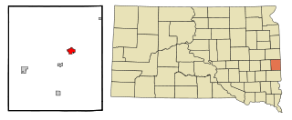
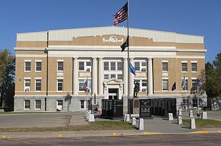
Beadle County is a county in the U.S. state of South Dakota. As of the 2020 census, the population was 19,149, making it the 11th most populous county in South Dakota. Its county seat is Huron. The county was created in 1879 and organized in 1880. Beadle County comprises the Huron, SD Micropolitan Statistical Area.

<span class="mw-page-title-main">Wolsey, South Dakota</span> Town in South Dakota, United States

Wolsey is a town in Beadle County, South Dakota, United States. The population was 459 at the 2020 census.

<span class="mw-page-title-main">Aurora, South Dakota</span> Town in South Dakota, United States

Aurora is a town in Brookings County, South Dakota, United States. The population was 1,047 at the 2020 census.

<span class="mw-page-title-main">Wallace, South Dakota</span> Town in South Dakota, United States

Wallace is a town in Codington County, South Dakota, United States. The population was 91 at the 2020 census. It is part of the Watertown, South Dakota Micropolitan Statistical Area.

<span class="mw-page-title-main">McIntosh, South Dakota</span> City in South Dakota, United States

McIntosh is a city in and the county seat of Corson County, South Dakota, United States. The population was 173 at the 2010 census and 111 at the 2020 United States Census.

<span class="mw-page-title-main">Custer, South Dakota</span> City in South Dakota, United States

Custer is a city in Custer County, South Dakota, United States. The population was 1,919 at the 2020 census. It is the county seat of Custer County.

<span class="mw-page-title-main">Mitchell, South Dakota</span> City in South Dakota, United States

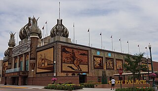
Mitchell is a city in and the county seat of Davison County, South Dakota, United States. The population was 15,660 at the 2020 census making it the sixth most populous city in South Dakota.

<span class="mw-page-title-main">Edgemont, South Dakota</span> City in South Dakota, United States

Edgemont is a city in Fall River County, South Dakota, United States. The population was 725 at the 2020 census. The city lies on the far southern edge of the Black Hills in southwestern South Dakota.

<span class="mw-page-title-main">Philip, South Dakota</span> City in South Dakota, United States

Philip is a city in and the county seat of rural Haakon County, South Dakota, United States. The population was 759 at the 2020 census.

<span class="mw-page-title-main">Miller, South Dakota</span> City in South Dakota, United States

Miller is a city in and county seat of Hand County, South Dakota, United States. The population was 1,349 at the 2020 census.

<span class="mw-page-title-main">Spearfish, South Dakota</span> City in South Dakota, United States

Spearfish is a city in Lawrence County, South Dakota, United States. The population was 12,193 at the time of the 2020 census, making it the 10th most populous city in South Dakota. Spearfish is the largest city in Lawrence County and the home of Black Hills State University.

<span class="mw-page-title-main">Dell Rapids, South Dakota</span> City in South Dakota, United States

Dell Rapids is a city in Minnehaha County, South Dakota, United States. The population was 3,996 at the 2020 census. It is known as "The Little City with the Big Attractions."

<span class="mw-page-title-main">Flandreau, South Dakota</span> City in South Dakota, United States

FlandreauFLAN-droo is a city in and county seat of Moody County, South Dakota, United States. The population was 2,372 at the 2020 census. It was named in honor of Charles Eugene Flandrau, a judge in the territory and state of Minnesota. He is credited with saving the community of New Ulm, Minnesota, from destruction during conflict with the Sioux tribe in 1862.

<span class="mw-page-title-main">Doland, South Dakota</span> City in South Dakota, United States

Doland is a city in eastern Spink County, South Dakota, United States. The population was 199 at the 2020 census.

<span class="mw-page-title-main">Winner, South Dakota</span> City in South Dakota, United States

Winner is a city in central Tripp County, South Dakota, United States. The population was 2,921 at the 2020 census. It is the county seat of Tripp County. Winner also serves as the administrative center of neighboring Todd County, which does not have its own county seat. The nearest airport is Winner Regional Airport.

<span class="mw-page-title-main">Iroquois, South Dakota</span> City in South Dakota, United States

Iroquois is a city on the border of Beadle and Kingsbury counties in South Dakota, United States. The population was 292 at the 2020 census. The school building is located in Kingsbury County, while the school parking lot is located in Beadle County. Highway 14 runs directly through Iroquois.

<span class="mw-page-title-main">Box Elder, South Dakota</span> City in South Dakota, United States

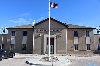
Box Elder is a city in Pennington and Meade counties in the State of South Dakota. The population was 11,746 at the 2020 census, making it the 11th most populous city in South Dakota. Ellsworth Air Force Base lies on the northeast side of the city.

Morningside is a census-designated place (CDP) in Beadle County, South Dakota, United States. The population was 70 at the 2020 census.

References

  1. 1 2 "History". City of Huron. Retrieved October 14, 2008.
  2. "ArcGIS REST Services Directory". United States Census Bureau. Retrieved October 15, 2022.
  3. 1 2 "Census Population API". United States Census Bureau. Retrieved October 15, 2022.
  4. 1 2 "U.S. Census website". United States Census Bureau . Retrieved January 31, 2008.
  5. "US Board on Geographic Names". United States Geological Survey. October 25, 2007. Retrieved January 31, 2008.
  6. "Find a County". National Association of Counties. Archived from the original on May 31, 2011. Retrieved June 7, 2011.
  7. "U.S. Census Bureau: Huron city, South Dakota". www.census.gov. United States Census Bureau. Retrieved February 4, 2022.
  8. Federal Writers' Project (1940). South Dakota place-names, v.1-3. University of South Dakota. p. 43.
  9. Brown, Greg; Jocelyn Sloan; Uther Draken (July 24, 2005). "Huron, South Dakota - World's Largest Pheasant". RoadsideAmerica.com. Retrieved October 19, 2007.
  10. History of the Origin of the Place Names in Nine Northwestern States. 1908. p. 11.
  11. "A Capital Fight Choosing South Dakota's Capital City" (PDF).
  12. "US Gazetteer files 2010". United States Census Bureau. Archived from the original on January 25, 2012. Retrieved June 21, 2012.
  13. "USDA Plant Hardiness Zone Map". United States Department of Agriculture. Archived from the original on February 27, 2014. Retrieved June 1, 2014.
  14. 1 2 3 4 5 6 7 8 "NowData - NOAA Online Weather Data". National Oceanic and Atmospheric Administration. Retrieved October 14, 2021.
  15. 1 2 "Station: Huron RGNL AP, SD". U.S. Climate Normals 2020: U.S. Monthly Climate Normals (1991-2020). National Oceanic and Atmospheric Administration. Retrieved October 14, 2021.
  16. ThreadEx
  17. "WMO Climate Normals for Huron/Huron Regional, SD 1961–1990". National Oceanic and Atmospheric Administration. Retrieved October 14, 2021.
  18. United States Census Bureau. "Census of Population and Housing" . Retrieved September 23, 2013.
  19. "U.S. Census website". United States Census Bureau . Retrieved June 21, 2012.
  20. "2020 CENSUS - SCHOOL DISTRICT REFERENCE MAP: Beadle County, SD" (PDF). U.S. Census Bureau . Retrieved April 10, 2024. - Text list
  21. "Aged Resident of Kalispell Dead". Great Falls Tribune . Great Falls, MT. January 10, 1917. p. 3 via Newspapers.com.
  22. Taylor, Sec (August 25, 1950). "Caddock, Ex-Wrestling King, Dies". Des Moines Tribune . Des Moines, IA. p. 14 via Newspapers.com.
  23. Kierstead, Mary D. (August 26, 1984). "The Talk of the Town: J. L. Carr". The New Yorker . New York, NY.
  24. Leavitt, Judith A. (1985). American Women Managers and Administrators. Westport, CT: Greenwood Press. p. 50. ISBN   978-0-313-23748-5 via Google Books.
  25. Lee, Stephen (May 22, 2015). "Bosworth takes stand in her trial". Capital Journal . Pierre, SD.
  26. "Biography, John King Fairbank". Papers of John K. Fairbank. Cambridge, MA: Harvard University Archives. Retrieved March 24, 2022.
  27. Fetter, Theodore J. (1977). A History of the United States Court of Appeals for the Eighth Circuit. Washington, DC: Judicial Conference of the United States Bicentennial Committee. p. 50 via Google Books.
  28. "Obituary, Robert E. Glanzer". Kuhler Funeral Home.com. Huron, SD: Kuhler Funeral Home. April 3, 2020.
  29. Young, Molly (April 2018). "Devonte Hart's mother: tracing her life from the Midwest to her drive off the California cliff". The Oregonian . Retrieved December 30, 2019.
  30. Gevik, Brian (August 1, 2016). "Native Candace Hilligoss on Her 1962 Cult Film Classic, "Carnival of Souls"". SDPB.org. Vermillion, SD: South Dakota Public Broadcasting.
  31. "Remembrance: Muriel Humphrey, Wife of Hubert Humphrey, was a Political Leader in Her Own Right". Hubert H. Humphrey School of Public Affairs. Minneapolis, MN: University of Minnesota. January 1, 2022.
  32. "Raymond Johnson named to Wyoming Aviation Hall of Fame, September 23, 2013" . Retrieved September 26, 2013.
  33. "Biography, Craig A. Kennedy". Yankton Lawyers.com. Yankton, SD: Kennedy Pier Loftus Reynolds, LLP. Retrieved March 24, 2022.
  34. "Biography, Cheryl Ladd". Turner Classic Movies. New York, NY: WarnerMedia Company. Retrieved March 24, 2022.
  35. "Verne Miller Time Line". Wayward Soldier: Verne Miller and the Kansas City Massacre. Vermillion, SD: South Dakota Public Broadcasting. Retrieved March 24, 2022.
  36. L.R.H.; Mattern, Carolyn J. (December 2, 2021). "Biography/History, Arthur L. Padrutt". Arthur L. Padrutt Papers. University of Wisconsin Eau Claire. Retrieved March 24, 2022.
  37. Minnesota Legislators: Past & Present-John M. Patton
  38. "Biographical / Historical, Gladys Pyle". Gladys Pyle Papers. Vermillion, SD: University of South Dakota. Retrieved March 24, 2022.
  39. Tomlinson & Day (August 16, 1898). "Biographical Sketch, John L. Pyle". Argus Leader . Sioux Falls, SD. p. 6 via Newspapers.com.
  40. "Biographical Sketch, John L. Pyle", p. 6.
  41. "Biography, Mike Rounds". NGA.org. Washington, DC: National Governors Association. Retrieved March 24, 2022.
  42. Sirvaitis, Karen (September 1, 2001). South Dakota. Lerner Publications. p. 69. ISBN   978-0-8225-4070-0.
  43. Pfankuch, Bart (May 19, 2017). "Black Hills resident reflects on time as head of US Peace Corps". Rapid City Journal . Rapid City, SD.
  44. "Will We Lose Him?". Argus Leader . Sioux Falls, SD. July 11, 1903. p. 11 via Newspapers.com.
  45. "About the Treasurer" . Retrieved January 31, 2020.

Furthur reading