Edmunds County, South Dakota

Last updated

Edmunds County
Bank Of Bowdle NRHP 85000183 Edmunds County, SD.jpg
Map of South Dakota highlighting Edmunds County.svg
Location within the U.S. state of South Dakota
South Dakota in United States.svg
South Dakota's location within the U.S.
Coordinates: 45°25′N99°13′W / 45.41°N 99.21°W / 45.41; -99.21
CountryFlag of the United States.svg United States
StateFlag of South Dakota.svg  South Dakota
Founded1873 (founded)
1883 (organized)
Named for Newton Edmunds
Seat Ipswich
Largest cityIpswich
Area
  Total1,151 sq mi (2,980 km2)
  Land1,126 sq mi (2,920 km2)
  Water25 sq mi (60 km2)  2.2%
Population
 (2020)
  Total3,986
  Estimate 
(2023)
4,057 Increase2.svg
  Density3.5/sq mi (1.3/km2)
Time zone UTC−6 (Central)
  Summer (DST) UTC−5 (CDT)
Congressional district At-large
Website edmunds.sdcounties.org

Edmunds County is a county in the U.S. state of South Dakota. At the 2020 census, the population was 3,986. [1] Its county seat is Ipswich. [2] The county was established in 1873 and organized in 1883. [3] It is named for Newton Edmunds, the second Governor of Dakota Territory. [4]

Contents

Edmunds County is part of the Aberdeen, SD Micropolitan Statistical Area.

Geography

The terrain of Edmunds County consists of rolling hills, mostly dedicated to agriculture. The terrain's highest point is on the west portion of the north boundary line, at 1,978 ft (603 m) ASL. [5] The county has a total area of 1,151 square miles (2,980 km2), of which 1,126 square miles (2,920 km2) is land and 25 square miles (65 km2) (2.2%) is water. [6]

Major highways

Adjacent counties

Protected areas

  • Bowdle-Hosmer State Game Production Area [7]
  • Heilman State Game Production Area [8]
  • Hosmer State Game Production Area [9]
  • Light State Game Production Area
  • Losee State Game Production Area
  • Mina Lake State Recreation Area [10]
  • Mina State Game Production Area
  • North Scatterwood State Game Production Area
  • Rosette State Game Production Area
  • Schaber State Game Production Area
  • Shaner State Game Production Area
  • Steigelmier State Game Production Area [11]

Lakes

  • Alkali Lake
  • Bowdle-Hosmer Lake
  • Grass Lake
  • Lake Parmley
  • North Scatterwood Lake (partial)

Demographics

Historical population
CensusPop.Note
1890 4,399
1900 4,91611.8%
1910 7,65455.7%
1920 8,3368.9%
1930 8,7124.5%
1940 7,814−10.3%
1950 7,275−6.9%
1960 6,079−16.4%
1970 5,548−8.7%
1980 5,159−7.0%
1990 4,356−15.6%
2000 4,3670.3%
2010 4,071−6.8%
2020 3,986−2.1%
2023 (est.)4,057 [12] 1.8%
U.S. Decennial Census [13]
1790-1960 [14] 1900-1990 [15]
1990-2000 [16] 2010-2020 [1]

2020 census

As of the 2020 census, there were 3,986 people, 1,546 households, and 1,052 families residing in the county. [17] The population density was 3.5 inhabitants per square mile (1.4/km2). There were 1,940 housing units.

2010 census

As of the 2010 census, there were 4,071 people, 1,607 households and 1,057 families residing in the county. The population density was 3.6 per square mile (1.4/km2). There were 1,966 housing units at an average density of 1.7 per square mile (0.66/km2). The racial make-up of the county was 97.8% white, 0.4% American Indian, 0.1% black or African American, 0.1% Asian, 0.5% from other races, and 1.0% from two or more races. Those of Hispanic or Latino origin made up 1.4% of the population. In terms of ancestry, 70.8% were German, 11.4% were Norwegian, 10.1% were Russian, 5.9% were English and 2.4% were American.

Of the 1,607 households, 26.4% had children under the age of 18 living with them, 58.9% were married couples living together, 4.0% had a female householder with no husband present, 34.2% were non-families, and 31.0% of all households were made up of individuals. The average household size was 2.27 and the average family size was 2.84. The median age was 45.7 years.

The median household income was $47,026 and the median family income was $56,599. Males had a median income of $37,713 and females $26,287. The per capita income was $24,268. About 6.9% of families and 11.6% of the population were below the poverty line, including 11.0% of those under age 18 and 13.6% of those age 65 or over.

Notable events

Edmunds County is where the Learjet of the PGA golfer Payne Stewart crashed, killing him and five others on board. The plane crashed just south of the community of Mina at the approximate coordinates of 45°25' N 98°45' W.

Communities

Cities

Census-designated places

Unincorporated communities

Townships

Politics

Edmunds County voters have long been reliably Republican. Since 1936, in only three elections has the county selected the Democratic Party candidate. Although it was one of only 129 counties nationwide to back George McGovern in his landslide 1972 defeat, it has voted for fewer Democratic presidential nominees (six) than any other county McGovern carried, with Jimmy Carter in 1976 the last Democrat to carry the county and Hillary Clinton not passing twenty percent in 2016.

United States presidential election results for Edmunds County, South Dakota [20]
Year Republican Democratic Third party
No.%No.%No.%
2020 1,53877.48%41721.01%301.51%
2016 1,43374.71%38019.81%1055.47%
2012 1,26465.29%62232.13%502.58%
2008 1,21358.43%81939.45%442.12%
2004 1,43464.19%76534.24%351.57%
2000 1,25763.29%67634.04%532.67%
1996 1,05545.67%97342.12%28212.21%
1992 94441.77%89439.56%42218.67%
1988 1,32751.06%1,25948.44%130.50%
1984 1,55360.43%1,00739.18%100.39%
1980 1,88164.55%88330.30%1505.15%
1976 1,29444.13%1,62955.56%90.31%
1972 1,56748.73%1,64651.18%30.09%
1968 1,53452.18%1,22541.67%1816.16%
1964 1,44245.78%1,70854.22%00.00%
1960 1,72851.78%1,60948.22%00.00%
1956 1,68551.61%1,58048.39%00.00%
1952 2,17868.25%1,01331.75%00.00%
1948 1,49354.00%1,25345.32%190.69%
1944 1,76264.71%96135.29%00.00%
1940 2,34161.87%1,44338.13%00.00%
1936 1,81846.76%2,03052.21%401.03%
1932 1,18330.84%2,58867.47%651.69%
1928 1,74351.95%1,59747.60%150.45%
1924 1,04342.38%27711.26%1,14146.36%
1920 1,48660.36%28311.49%69328.15%
1916 89455.46%63439.33%845.21%
1912 00.00%72949.12%75550.88%
1908 72650.14%65845.44%644.42%
1904 78665.88%35329.59%544.53%
1900 62151.97%55346.28%211.76%
1896 37141.78%51057.43%70.79%
1892 38644.22%15617.87%33137.92%

See also

Related Research Articles

<span class="mw-page-title-main">Walworth County, South Dakota</span> County in South Dakota, United States

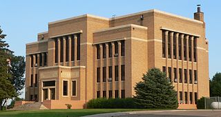
Walworth County is a county in the U.S. state of South Dakota. As of the 2020 census, the population was 5,315. Its county seat is Selby. The county was created in 1873 and organized in 1883. It is named for Walworth County, Wisconsin.

<span class="mw-page-title-main">Union County, South Dakota</span> County in South Dakota, United States

Union County is the southernmost county in the U.S. state of South Dakota. As of the 2020 census, the population was 16,811, making it the 13th most populous county in South Dakota. Its county seat has been Elk Point since April 30, 1865. Originally named Cole County, its name was changed to Union on January 7, 1864, because of Civil War sentiment.

<span class="mw-page-title-main">Roberts County, South Dakota</span> County in South Dakota, United States

Roberts County is a county in the U.S. state of South Dakota. As of the 2020 census, the population was 10,280. Its county seat is Sisseton. The county was named either for S. G. Roberts of Fargo, North Dakota, or for Solomon Robar, an early local French fur trader. It was created on March 8, 1883, and fully organized by August 6 of that year. Its boundary was altered once, in 1885.

<span class="mw-page-title-main">Potter County, South Dakota</span> County in South Dakota, United States

Potter County is a county in the U.S. state of South Dakota. As of the 2020 census, the population was 2,472. Its county seat is Gettysburg. The county was created in 1873 and organized in 1883.

<span class="mw-page-title-main">McPherson County, South Dakota</span> County in South Dakota, United States

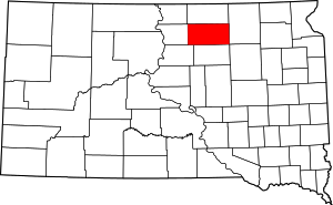
McPherson County is a county in the U.S. state of South Dakota. As of the 2020 census, the population was 2,411. Its county seat is Leola.

<span class="mw-page-title-main">McCook County, South Dakota</span> County in South Dakota, United States

McCook County is a county in the U.S. state of South Dakota. At the 2020 census, the population was 5,682. Its county seat is Salem. The county was established in 1873, and was organized in 1878. It was named for the former governor of the Dakota Territory and Civil War general Edwin Stanton McCook.

<span class="mw-page-title-main">Marshall County, South Dakota</span> County in South Dakota, United States

Marshall County is a county in the U.S. state of South Dakota. As of the 2020 census, the population was 4,306. Its county seat is Britton. The county was created on May 2, 1885, and was named for Marshall Vincent, who homesteaded near Andover, South Dakota.

<span class="mw-page-title-main">Gregory County, South Dakota</span> County in South Dakota, United States

Gregory County is a county in the U.S. state of South Dakota. As of the 2020 census, the population was 3,994. Its county seat is Burke. The county was created in 1862 and organized in 1898. It was named for the politician J. Shaw Gregory.

<span class="mw-page-title-main">Grant County, South Dakota</span> County in South Dakota, United States

Grant County is a county in the U.S. state of South Dakota. As of the 2020 census, the population was 7,556. The county seat is Milbank. The county was founded in 1873 and organized in 1878. It is named for Ulysses S. Grant, 18th President of the United States.

<span class="mw-page-title-main">Faulk County, South Dakota</span> County in South Dakota, United States

Faulk County is a county in the U.S. state of South Dakota. As of the 2020 census, the population was 2,125. Its county seat is Faulkton. The county was founded in 1873 and organized in 1883. It is named for Andrew Jackson Faulk, the third Governor of Dakota Territory.

<span class="mw-page-title-main">Deuel County, South Dakota</span> County in South Dakota, United States

Deuel County is a county in the U.S. state of South Dakota. As of the 2020 census, the population was 4,295. Its county seat is Clear Lake. The county was created in 1862, and was organized in 1878. It is named for Jacob Deuel, a legislator in 1862.

<span class="mw-page-title-main">Corson County, South Dakota</span> County in South Dakota, United States

Corson County is a county in the U.S. state of South Dakota. As of the 2020 census, the population was 3,902. Its county seat is McIntosh. The county was named for Dighton Corson, a native of Maine, who came to the Black Hills in 1876, and in 1877 began practicing law at Deadwood.

<span class="mw-page-title-main">Codington County, South Dakota</span> County in South Dakota, United States

Codington County is a county in the U.S. state of South Dakota. As of the 2020 census, the population was 28,325, making it the 7th most populous county in South Dakota. Its county seat is Watertown. The county was created in 1877 and organized in 1878. It is named for Rev. George S. S. Codington, Dakota Territory legislator.

<span class="mw-page-title-main">Charles Mix County, South Dakota</span> County in South Dakota, United States

Charles Mix County is a county in the U.S. state of South Dakota. As of the 2020 census, the population was 9,373. Its county seat is Lake Andes. The county was created in 1862 and organized in 1879. It was named for Charles Eli Mix, an official of the Bureau of Indian Affairs influential in signing a peace treaty with the local Lakota Indian tribes. The easternmost approximately 60% of the county comprises the Yankton Indian Reservation.

<span class="mw-page-title-main">Campbell County, South Dakota</span> County in South Dakota, United States

Campbell County is a county in the U.S. state of South Dakota. As of the 2020 census, the population was 1,377, making it the fourth-least populous county in South Dakota. Its county seat is Mound City. The county was created in 1873 and organized in 1884. It was named for Norman B. Campbell, a Dakota Territory legislator in 1873 and son of General Charles T. Campbell.

<span class="mw-page-title-main">Brule County, South Dakota</span> County in South Dakota, United States

Brule County is a county in the U.S. state of South Dakota. As of the 2020 census, the population was 5,247. Its county seat is Chamberlain.

<span class="mw-page-title-main">Brown County, South Dakota</span> County in South Dakota, United States

Brown County is a county in the U.S. state of South Dakota. As of the 2020 census, the population was 38,301, making it the fourth most populous county in South Dakota. Its county seat is Aberdeen. The county is named for Alfred Brown, of Hutchinson County, South Dakota, a Dakota Territory legislator in 1879.

<span class="mw-page-title-main">Brookings County, South Dakota</span> County in South Dakota, United States

Brookings County is a county in the U.S. state of South Dakota. As of the 2020 census, the population was 34,375, making it the fifth most populous county in South Dakota. Its county seat is Brookings. The county was created in 1862 and organized in 1871.

<span class="mw-page-title-main">Beadle County, South Dakota</span> County in South Dakota, United States

Beadle County is a county in the U.S. state of South Dakota. As of the 2020 census, the population was 19,149, making it the 11th most populous county in South Dakota. Its county seat is Huron. The county was created in 1879 and organized in 1880. Beadle County comprises the Huron, SD Micropolitan Statistical Area.

<span class="mw-page-title-main">Aurora County, South Dakota</span> County in South Dakota, United States

Aurora County is a county in the U.S. state of South Dakota. As of the 2020 census, the population was 2,747. The county was created in 1879, and was organized in 1881.

References

  1. 1 2 "State & County QuickFacts". United States Census Bureau . Retrieved March 21, 2024.
  2. "Find a County". National Association of Counties. Archived from the original on July 4, 2012. Retrieved June 7, 2011.
  3. "Dakota Territory, South Dakota, and North Dakota: Individual County Chronologies". Dakota Territory Atlas of Historical County Boundaries. The Newberry Library. 2006. Archived from the original on April 2, 2018. Retrieved March 29, 2015.
  4. Gannett, Henry (1905). The Origin of Certain Place Names in the United States. Govt. Print. Off. p. 115.
  5. ""Find an Altitude" Google Maps (accessed February 2, 2019)". Archived from the original on May 21, 2019. Retrieved February 3, 2019.
  6. "2010 Census Gazetteer Files". United States Census Bureau. August 22, 2012. Retrieved March 24, 2015.
  7. Bowdle-Hosmer Public Shooting Area, Bowdle SD, Google Maps. Retrieved February 2, 2019.
  8. Heilman State Public Shooting Area, Bowdle SD, Google Maps. Retrieved February 2, 2019.
  9. Hosmer State Public Shooting Area, Hosmer SD, Google Maps. Retrieved February 2, 2019.
  10. Mina Lake State Recreation Area, Google Maps. Retrieved February 2, 2019.
  11. Steigelmier State Public Shooting Area, Onaka SD, Google Maps. Retrieved February 2, 2019.
  12. "County Population Totals and Components of Change: 2020-2023" . Retrieved March 17, 2024.
  13. "U.S. Decennial Census". United States Census Bureau. Retrieved March 24, 2015.
  14. "Historical Census Browser". University of Virginia Library. Retrieved March 24, 2015.
  15. Forstall, Richard L., ed. (March 27, 1995). "Population of Counties by Decennial Census: 1900 to 1990". United States Census Bureau. Retrieved March 24, 2015.
  16. "Census 2000 PHC-T-4. Ranking Tables for Counties: 1990 and 2000" (PDF). United States Census Bureau. April 2, 2001. Archived (PDF) from the original on October 9, 2022. Retrieved October 4, 2020.
  17. "US Census Bureau, Table P16: Household Type". United States Census Bureau. Retrieved March 21, 2024.
  18. Craven SD, Google Maps. Retrieved February 2, 2019.
  19. Gretna SD, Google Maps. Retrieved February 2, 2019.
  20. Leip, David. "Atlas of US Presidential Elections". uselectionatlas.org. Retrieved April 15, 2018.

45°25′N99°13′W / 45.41°N 99.21°W / 45.41; -99.21