Roscoe, South Dakota

Last updated

Roscoe, South Dakota
City
Roscoe, South Dakota - panoramio.jpg
Billboard and farmland in Roscoe, May 2007
Edmunds County South Dakota Incorporated and Unincorporated areas Roscoe Highlighted.svg
Location in Edmunds County and the state of South Dakota
Coordinates: 45°27′00″N99°20′12″W / 45.45000°N 99.33667°W / 45.45000; -99.33667
CountryUnited States
State South Dakota
County Edmunds
Founded1877 [1]
Area
[2]
  Total0.38 sq mi (0.99 km2)
  Land0.38 sq mi (0.99 km2)
  Water0.00 sq mi (0.00 km2)
Elevation
[3]
1,834 ft (559 m)
Population
 (2020) [4]
  Total269
  Density704.19/sq mi (271.91/km2)
Time zone UTC-6 (Central (CST))
  Summer (DST) UTC-5 (CDT)
ZIP code
57471
Area code 605
FIPS code 46-55820 [5]
GNIS feature ID1267554 [3]
Website www.roscoesd.org

Roscoe is a city in central Edmunds County, South Dakota, United States. The population was 269 at the 2020 census. [6]

Contents

Roscoe was laid out in 1877, and named in honor of Roscoe Conkling, a United States Senator from New York. [7]

Geography

According to the United States Census Bureau, the city has a total area of 0.47 square miles (1.22 km2), all land. [8]

Climate

Climate data for Roscoe, South Dakota (1991−2020 normals, extremes 1935−present)
MonthJanFebMarAprMayJunJulAugSepOctNovDecYear
Record high °F (°C)59
(15)
68
(20)
83
(28)
94
(34)
102
(39)
107
(42)
112
(44)
108
(42)
102
(39)
93
(34)
77
(25)
62
(17)
112
(44)
Average high °F (°C)21.4
(−5.9)
26.1
(−3.3)
38.7
(3.7)
54.2
(12.3)
66.9
(19.4)
76.8
(24.9)
82.8
(28.2)
81.4
(27.4)
72.6
(22.6)
56.7
(13.7)
39.8
(4.3)
26.4
(−3.1)
53.7
(12.1)
Daily mean °F (°C)12.3
(−10.9)
16.4
(−8.7)
28.3
(−2.1)
42.1
(5.6)
54.9
(12.7)
65.5
(18.6)
70.8
(21.6)
68.8
(20.4)
59.6
(15.3)
45.0
(7.2)
29.9
(−1.2)
17.8
(−7.9)
42.6
(5.9)
Average low °F (°C)3.2
(−16.0)
6.7
(−14.1)
17.9
(−7.8)
29.9
(−1.2)
43.0
(6.1)
54.2
(12.3)
58.7
(14.8)
56.2
(13.4)
46.6
(8.1)
33.3
(0.7)
19.9
(−6.7)
9.2
(−12.7)
31.6
(−0.2)
Record low °F (°C)−37
(−38)
−34
(−37)
−24
(−31)
1
(−17)
17
(−8)
29
(−2)
38
(3)
36
(2)
21
(−6)
−2
(−19)
−19
(−28)
−35
(−37)
−37
(−38)
Average precipitation inches (mm)0.54
(14)
0.66
(17)
0.95
(24)
1.84
(47)
3.16
(80)
3.70
(94)
3.24
(82)
2.30
(58)
1.91
(49)
1.79
(45)
0.69
(18)
0.64
(16)
21.42
(544)
Average snowfall inches (cm)8.1
(21)
8.8
(22)
7.3
(19)
5.8
(15)
0.1
(0.25)
0.0
(0.0)
0.0
(0.0)
0.0
(0.0)
0.0
(0.0)
2.3
(5.8)
5.9
(15)
8.7
(22)
47.0
(119)
Average precipitation days (≥ 0.01 in)6.96.66.68.110.711.89.98.07.47.45.56.295.1
Average snowy days (≥ 0.1 in)7.36.94.62.40.10.00.00.00.01.33.76.733.0
Source: NOAA [9] [10]

Demographics

Historical population
CensusPop.Note
1890 114
1900 92−19.3%
1910 357288.0%
1920 45928.6%
1930 4917.0%
1940 60823.8%
1950 72619.4%
1960 532−26.7%
1970 398−25.2%
1980 370−7.0%
1990 362−2.2%
2000 324−10.5%
2010 3291.5%
2020 269−18.2%
U.S. Decennial Census [11] [4]

2010 census

As of the census [12] of 2010, there were 329 people, 153 households, and 83 families residing in the city. The population density was 700.0 inhabitants per square mile (270.3/km2). There were 177 housing units at an average density of 376.6 per square mile (145.4/km2). The racial makeup of the city was 97.0% White, 0.9% African American, 0.3% Native American, and 1.8% from two or more races. Hispanic or Latino of any race were 4.6% of the population.

There were 153 households, of which 26.1% had children under the age of 18 living with them, 45.8% were married couples living together, 3.9% had a female householder with no husband present, 4.6% had a male householder with no wife present, and 45.8% were non-families. 42.5% of all households were made up of individuals, and 24.8% had someone living alone who was 65 years of age or older. The average household size was 2.15 and the average family size was 2.95.

The median age in the city was 38.2 years. 26.1% of residents were under the age of 18; 8% were between the ages of 18 and 24; 21% were from 25 to 44; 21% were from 45 to 64; and 24% were 65 years of age or older. The gender makeup of the city was 47.1% male and 52.9% female.

2000 census

As of the census [5] of 2000, there were 324 people, 145 households, and 82 families residing in the city. The population density was 692.1 inhabitants per square mile (267.2/km2). There were 167 housing units at an average density of 356.7 per square mile (137.7/km2). The racial makeup of the city was 99.69% White, and 0.31% from two or more races. Hispanic or Latino of any race were 0.31% of the population.

There were 145 households, out of which 25.5% had children under the age of 18 living with them, 51.0% were married couples living together, 4.1% had a female householder with no husband present, and 42.8% were non-families. 38.6% of all households were made up of individuals, and 23.4% had someone living alone who was 65 years of age or older. The average household size was 2.23 and the average family size was 3.07.

In the city, the population was spread out, with 27.5% under the age of 18, 4.6% from 18 to 24, 24.7% from 25 to 44, 15.4% from 45 to 64, and 27.8% who were 65 years of age or older. The median age was 40 years. For every 100 females, there were 82.0 males. For every 100 females age 18 and over, there were 92.6 males.

The median income for a household in the city was $24,875, and the median income for a family was $36,250. Males had a median income of $27,500 versus $13,056 for females. The per capita income for the city was $16,451. About 2.9% of families and 8.9% of the population were below the poverty line, including none of those under age 18 and 13.8% of those age 65 or over.

A stone building in Roscoe, 1987 Stone building, Roscoe, South Dakota LCCN2017707082.tif
A stone building in Roscoe, 1987

Transportation

Roscoe is served by two major highways:

See also

Related Research Articles

<span class="mw-page-title-main">White, South Dakota</span> City in South Dakota, United States

White is a city in Brookings County, South Dakota, United States. The population was 537 at the 2020 census.

<span class="mw-page-title-main">Chamberlain, South Dakota</span> City in South Dakota, United States

Chamberlain is a city in Brule County, South Dakota, United States. It is located on the east bank of the Missouri River, at the dammed section of the Lake Francis Case, close to where it is crossed by Interstate 90.

<span class="mw-page-title-main">Newell, South Dakota</span> City in South Dakota, United States

Newell is a city in Butte County, South Dakota, United States. The population was 584 at the 2020 census.

<span class="mw-page-title-main">Wagner, South Dakota</span> City in South Dakota, United States

Wagner is a city in Charles Mix County, South Dakota, United States. The population was 1,490 at the 2020 census. The city is served by Wagner Municipal Airport as well as YST Transit buses.

<span class="mw-page-title-main">Garden City, South Dakota</span> Town in South Dakota, United States

Garden City is a town in Clark County, South Dakota, United States. The population was 33 at the 2020 census.

<span class="mw-page-title-main">Bowdle, South Dakota</span> City in South Dakota, United States

Bowdle ( is a city in Edmunds County, South Dakota, United States. The population was 470 at the 2020 census.

<span class="mw-page-title-main">Hosmer, South Dakota</span> City in South Dakota, United States

Hosmer is a city in northwestern Edmunds County, South Dakota, United States. The population was 164 at the 2020 census.

<span class="mw-page-title-main">Ipswich, South Dakota</span> City in South Dakota, United States

Ipswich is a city in and county seat of Edmunds County, South Dakota, United States. The population was 928 at the 2020 census.

<span class="mw-page-title-main">Miller, South Dakota</span> City in South Dakota, United States

Miller is a city in and county seat of Hand County, South Dakota, United States. The population was 1,349 at the 2020 census.

<span class="mw-page-title-main">Menno, South Dakota</span> City in South Dakota, United States

Menno is a city in Hutchinson County, South Dakota, United States. The population was 614 at the 2020 census.

<span class="mw-page-title-main">Parkston, South Dakota</span> City in South Dakota, United States

Parkston is a city in Hutchinson County, South Dakota, United States. The population was 1,567 at the 2020 census.

<span class="mw-page-title-main">Cottonwood, South Dakota</span> Town in the United States

Cottonwood is a small rural hamlet in Jackson County, South Dakota, United States. The population was 12 at the 2020 census. There are no businesses or services at Cottonwood.

<span class="mw-page-title-main">Murdo, South Dakota</span> City in South Dakota, United States

Murdo is a city in and county seat of Jones County, South Dakota, United States. The population was 475 at the 2020 census.

<span class="mw-page-title-main">Central City, South Dakota</span> City in South Dakota, United States

Central City is a city in Lawrence County, South Dakota, United States. The population was 93 at the 2020 census.

<span class="mw-page-title-main">Whitewood, South Dakota</span> City in South Dakota, United States

Whitewood is a city in Lawrence County, South Dakota, United States. The population was 879 at the 2020 census.

<span class="mw-page-title-main">Ashton, South Dakota</span> City in South Dakota, United States

Ashton is a city in eastern Spink County, South Dakota, United States. The population was 108 at the 2020 census.

<span class="mw-page-title-main">Mellette, South Dakota</span> City in South Dakota, United States

Mellette is a city in Spink County, South Dakota, United States. The population was 199 at the 2020 census.

<span class="mw-page-title-main">Elk Point, South Dakota</span> City in South Dakota, United States

Elk Point is a city in and county seat of Union County, South Dakota, United States. The population was 2,149 as of the 2020 census.

<span class="mw-page-title-main">Iroquois, South Dakota</span> City in South Dakota, United States

Iroquois is a city on the border of Beadle and Kingsbury counties in South Dakota, United States. The population was 292 at the 2020 census. The school building is located in Kingsbury County, while the school parking lot is located in Beadle County. Highway 14 runs directly through Iroquois.

<span class="mw-page-title-main">Box Elder, South Dakota</span> City in South Dakota, United States

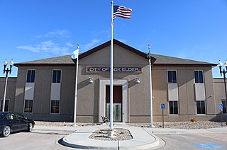
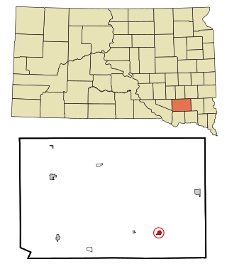
Box Elder is a city in Pennington and Meade counties in the State of South Dakota. The population was 11,746 according to the 2020 census, making it the 11th most populous city in South Dakota. Ellsworth Air Force Base lies on the northeast side of the city.

References

  1. "SD Towns" (PDF). South Dakota State Historical Society . Retrieved February 15, 2010.
  2. "ArcGIS REST Services Directory". United States Census Bureau. Retrieved October 15, 2022.
  3. 1 2 U.S. Geological Survey Geographic Names Information System: Roscoe, South Dakota
  4. 1 2 "Census Population API". United States Census Bureau. Retrieved October 15, 2022.
  5. 1 2 "U.S. Census website". United States Census Bureau . Retrieved January 31, 2008.
  6. "U.S. Census Bureau: Roscoe city, South Dakota". www.census.gov. United States Census Bureau. Retrieved February 21, 2022.
  7. Federal Writers' Project (1940). South Dakota place-names, v.1-3. University of South Dakota. p. 59.
  8. "US Gazetteer files 2010". United States Census Bureau. Archived from the original on January 25, 2012. Retrieved June 21, 2012.
  9. "NowData - NOAA Online Weather Data". National Oceanic and Atmospheric Administration. Retrieved October 13, 2021.
  10. "Station: Roscoe, SD". U.S. Climate Normals 2020: U.S. Monthly Climate Normals (1991-2020). National Oceanic and Atmospheric Administration. Retrieved October 13, 2021.
  11. "Census of Population and Housing". Census.gov. Retrieved June 4, 2015.
  12. "U.S. Census website". United States Census Bureau . Retrieved June 21, 2012.