Hamlin County, South Dakota

Last updated

Hamlin County
Hamlin County Courthouse Hayti.jpg
Hamlin County Courthouse in Hayti in 1974
Map of South Dakota highlighting Hamlin County.svg
Location within the U.S. state of South Dakota
South Dakota in United States.svg
South Dakota's location within the U.S.
Coordinates: 44°41′N97°12′W / 44.68°N 97.2°W / 44.68; -97.2
CountryFlag of the United States.svg United States
StateFlag of South Dakota.svg  South Dakota
Founded1873 (created)
1878 (organized)
Named for Hannibal Hamlin
Seat Hayti
Largest city Estelline
Area
  Total538 sq mi (1,390 km2)
  Land507 sq mi (1,310 km2)
  Water31 sq mi (80 km2)  5.7%
Population
 (2020)
  Total6,164
  Estimate 
(2023)
6,451 Increase2.svg
  Density11/sq mi (4.4/km2)
Time zone UTC−6 (Central)
  Summer (DST) UTC−5 (CDT)
Congressional district At-large

Hamlin County is a county in the U.S. state of South Dakota. As of the 2020 census, the population was 6,164. [1] Its county seat is Hayti. [2] The county was created in 1873 and organized in 1878. [3] It was named for Hannibal Hamlin, Lincoln's first vice-president. [4]

Contents

Geography

Soils of Hamlin County Hamlin Co SD Pie Chart No Text Version.pdf
Soils of Hamlin County

The terrain of Hamlin County consists of low rolling hills, dotted with small lakes and ponds. The land is largely dedicated to agriculture. [5] The terrain slopes to the south-southeast, and its highest point is on the eastern boundary line, near its NE corner, at 1,949 ft (594 m) ASL. [6]

Hamlin County has a total area of 538 square miles (1,390 km2), of which 507 square miles (1,310 km2) is land and 31 square miles (80 km2) (5.7%) is water. [7]

Major highways

Adjacent counties

Protected areas

Source: [5]

  • Baxter Slough State Public Shooting Area
  • Bochek State Public Shooting Area
  • Eidsness State Public Shooting Area
  • Hamlin State Public Shooting Area
  • Harju State Public Shooting Area
  • Hayes Slough State Public Shooting Area
  • Johnsons Slough State Public Shooting Area
  • McShane State Public Shooting Area
  • Opdahl Slough State Public Shooting Area
  • Rasmussen State Public Shooting Area

Lakes

Source: [5]

  • Clear Lake
  • Dry Lake
  • Lake Albert (partial)
  • Lake Marsh
  • Lake Mary
  • Lake Norden
  • Lake Poinsett
  • Lake Saint John

Demographics

Historical population
CensusPop.Note
1880 693
1890 4,623567.1%
1900 5,94528.6%
1910 7,47525.7%
1920 8,0547.7%
1930 8,2993.0%
1940 7,562−8.9%
1950 7,058−6.7%
1960 6,303−10.7%
1970 5,172−17.9%
1980 5,2611.7%
1990 4,974−5.5%
2000 5,54011.4%
2010 5,9036.6%
2020 6,1644.4%
2023 (est.)6,451 [8] 4.7%
U.S. Decennial Census [9]
1790-1960 [10] 1900-1990 [11]
1990-2000 [12] 2010-2020 [1]

2020 census

As of the 2020 census, there were 6,164 people, 2,155 households, and 1,513 families residing in the county. [13] The population density was 12.2 inhabitants per square mile (4.7/km2). There were 2,759 housing units.

2010 census

As of the 2010 census, there were 5,903 people, 2,108 households, and 1,483 families in the county. The population density was 11.6 inhabitants per square mile (4.5/km2). There were 2,760 housing units at an average density of 5.4 units per square mile (2.1 units/km2). The racial makeup of the county was 96.7% white, 0.3% American Indian, 0.2% black or African American, 0.2% Asian, 1.8% from other races, and 0.8% from two or more races. Those of Hispanic or Latino origin made up 2.5% of the population. In terms of ancestry, 42.3% were German, 24.0% were Norwegian, 7.0% were English, 6.1% were Irish, 5.4% were Dutch, and 5.3% were American.

Of the 2,108 households, 33.2% had children under the age of 18 living with them, 61.4% were married couples living together, 5.6% had a female householder with no husband present, 29.6% were non-families, and 25.6% of all households were made up of individuals. The average household size was 2.68 and the average family size was 3.28. The median age was 36.8 years.

The median income for a household in the county was $44,439 and the median income for a family was $54,483. Males had a median income of $36,921 versus $24,645 for females. The per capita income for the county was $21,558. About 4.9% of families and 7.5% of the population were below the poverty line, including 11.5% of those under age 18 and 7.9% of those age 65 or over.

Communities

Cities

Towns

Census-designated place

Unincorporated communities

Source: [5]

Townships

  • Brantford
  • Castlewood
  • Cleveland
  • Dempster
  • Dixon
  • Estelline
  • Florence
  • Garfield
  • Hamlin
  • Hayti
  • Norden
  • Opdahl
  • Oxford

Politics

Hamlin County voters have usually voted Republican. In only one national election since 1932 has the county selected the Democratic Party candidate.

United States presidential election results for Hamlin County, South Dakota [14]
Year Republican Democratic Third party
No.%No.%No.%
2020 2,37276.94%64720.99%642.08%
2016 2,05174.26%55520.09%1565.65%
2012 1,80364.55%92132.98%692.47%
2008 1,66159.60%1,04337.42%832.98%
2004 1,94664.63%1,01533.71%501.66%
2000 1,73163.57%92333.90%692.53%
1996 1,35249.02%1,10139.92%30511.06%
1992 1,13341.35%82630.15%78128.50%
1988 1,38052.06%1,25847.45%130.49%
1984 1,78264.54%96334.88%160.58%
1980 1,88562.69%90330.03%2197.28%
1976 1,45250.66%1,40248.92%120.42%
1972 1,69356.85%1,27642.85%90.30%
1968 1,64956.36%1,14939.27%1284.37%
1964 1,52549.42%1,56150.58%00.00%
1960 2,13963.49%1,23036.51%00.00%
1956 2,08361.68%1,29438.32%00.00%
1952 2,39171.48%95428.52%00.00%
1948 1,60853.98%1,32644.51%451.51%
1944 1,81163.97%1,02036.03%00.00%
1940 2,27964.00%1,28236.00%00.00%
1936 1,85752.25%1,62245.64%752.11%
1932 1,26739.23%1,92059.44%431.33%
1928 1,95963.19%1,08835.10%531.71%
1924 1,14452.38%2079.48%83338.14%
1920 1,32263.68%33716.23%41720.09%
1916 1,03957.82%69238.51%663.67%
1912 00.00%47429.92%1,11070.08%
1908 1,09568.57%43427.18%684.26%
1904 1,19775.76%30719.43%764.81%
1900 92862.79%50934.44%412.77%
1896 70255.10%55943.88%131.02%
1892 53750.80%16115.23%35933.96%

Notable people

See also

Related Research Articles

<span class="mw-page-title-main">Miner County, South Dakota</span> County in South Dakota, United States

Miner County is a county in the U.S. state of South Dakota. As of the 2020 census, the population was 2,298. Its county seat is Howard. The county was created in 1873 and organized in 1880.

<span class="mw-page-title-main">McCook County, South Dakota</span> County in South Dakota, United States

McCook County is a county in the U.S. state of South Dakota. At the 2020 census, the population was 5,682. Its county seat is Salem. The county was established in 1873, and was organized in 1878. It was named for the former governor of the Dakota Territory and Civil War general Edwin Stanton McCook.

<span class="mw-page-title-main">Marshall County, South Dakota</span> County in South Dakota, United States

Marshall County is a county in the U.S. state of South Dakota. As of the 2020 census, the population was 4,306. Its county seat is Britton. The county was created on May 2, 1885, and was named for Marshall Vincent, who homesteaded near Andover, South Dakota.

<span class="mw-page-title-main">Lake County, South Dakota</span> County in South Dakota, United States

Lake County is a county in the U.S. state of South Dakota. As of the 2020 census, the population was 11,059. Its county seat is Madison. The county was formed in 1873.

<span class="mw-page-title-main">Kingsbury County, South Dakota</span> County in South Dakota, United States

Kingsbury County is a county in the U.S. state of South Dakota. As of the 2020 census, the population was 5,187. Its county seat is De Smet. The county was created in 1873, and was organized in 1880. It was named for brothers George W. and T. A. Kingsbury, descendants of the colonial English Kingsbury family in Boston, Massachusetts. They were prominently involved in the affairs of Dakota Territory and served as elected members of several Territorial Legislatures.

<span class="mw-page-title-main">Grant County, South Dakota</span> County in South Dakota, United States

Grant County is a county in the U.S. state of South Dakota. As of the 2020 census, the population was 7,556. The county seat is Milbank. The county was founded in 1873 and organized in 1878. It is named for Ulysses S. Grant, 18th President of the United States.

<span class="mw-page-title-main">Edmunds County, South Dakota</span> County in South Dakota, United States

Edmunds County is a county in the U.S. state of South Dakota. At the 2020 census, the population was 3,986. Its county seat is Ipswich. The county was established in 1873 and organized in 1883. It is named for Newton Edmunds, the second Governor of Dakota Territory.

<span class="mw-page-title-main">Deuel County, South Dakota</span> County in South Dakota, United States

Deuel County is a county in the U.S. state of South Dakota. As of the 2020 census, the population was 4,295. Its county seat is Clear Lake. The county was created in 1862, and was organized in 1878. It is named for Jacob Deuel, a legislator in 1862.

<span class="mw-page-title-main">Day County, South Dakota</span> County in South Dakota, United States

Day County is a county in the U.S. state of South Dakota. As of the 2020 census, the population was 5,449. Its county seat is Webster. The county is named for Merritt H. Day, pioneer and 1879 Dakota Territory legislator.

<span class="mw-page-title-main">Codington County, South Dakota</span> County in South Dakota, United States

Codington County is a county in the U.S. state of South Dakota. As of the 2020 census, the population was 28,325, making it the 7th most populous county in South Dakota. Its county seat is Watertown. The county was created in 1877 and organized in 1878. It is named for Rev. George S. S. Codington, Dakota Territory legislator.

<span class="mw-page-title-main">Clark County, South Dakota</span> County in South Dakota, United States

Clark County is a county in the U.S. state of South Dakota. As of the 2020 census, the population was 3,837. Its county seat is Clark. The county was created in 1873 and organized in 1881. It was named for Newton Clark, a Dakota Territory legislator in 1873.

<span class="mw-page-title-main">Brookings County, South Dakota</span> County in South Dakota, United States

Brookings County is a county in the U.S. state of South Dakota. As of the 2020 census, the population was 34,375, making it the fifth most populous county in South Dakota. Its county seat is Brookings. The county was created in 1862 and organized in 1871.

<span class="mw-page-title-main">Beadle County, South Dakota</span> County in South Dakota, United States

Beadle County is a county in the U.S. state of South Dakota. As of the 2020 census, the population was 19,149, making it the 11th most populous county in South Dakota. Its county seat is Huron. The county was created in 1879 and organized in 1880. Beadle County comprises the Huron, SD Micropolitan Statistical Area.

<span class="mw-page-title-main">Richland County, North Dakota</span> County in North Dakota, United States

Richland County is a county in the far southeast corner of the U.S. state of North Dakota. As of the 2020 census, the population was 16,529. Its county seat is Wahpeton.

<span class="mw-page-title-main">LaMoure County, North Dakota</span> County in North Dakota, United States

LaMoure County is a county in the U.S. state of North Dakota. As of the 2020 census, the population was 4,093. Its county seat is LaMoure.

<span class="mw-page-title-main">Estelline, South Dakota</span> City in South Dakota, United States

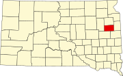
Estelline is a city in Hamlin County, South Dakota, United States. It is part of the Watertown, South Dakota Micropolitan Statistical Area. The population was 749 at the 2020 census.

<span class="mw-page-title-main">Hayti, South Dakota</span> Town in South Dakota, United States

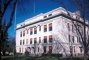
Hayti is a town in and county seat of Hamlin County, South Dakota, United States. The population was 393 at the 2020 census. It is part of the Watertown, South Dakota Micropolitan Statistical Area. It is the county seat of Hamlin County.

<span class="mw-page-title-main">Lake Norden, South Dakota</span> City in South Dakota, United States

Lake Norden is a city in Hamlin County, South Dakota, United States. It is part of the Watertown, South Dakota Micropolitan Statistical Area. The population was 554 at the 2020 census.

Lake Poinsett is a census-designated place (CDP) in Hamlin and Brookings counties in South Dakota, United States. The population was 501 at the 2020 census.

Poinsett Colony is a Hutterite colony and census-designated place (CDP) in Hamlin County, South Dakota, United States. The population was 5 at the 2020 census. It was first listed as a CDP prior to the 2020 census.

References

  1. 1 2 "State & County QuickFacts". United States Census Bureau. Retrieved March 21, 2024.
  2. "Find a County". National Association of Counties. Retrieved June 7, 2011.
  3. "Dakota Territory, South Dakota, and North Dakota: Individual County Chronologies". Dakota Territory Atlas of Historical County Boundaries. The Newberry Library. 2006. Archived from the original on April 2, 2018. Retrieved March 29, 2015.
  4. Gannett, Henry (1905). The Origin of Certain Place Names in the United States. Govt. Print. Off. p.  148.
  5. 1 2 3 4 "Hamlin County · South Dakota". Google Maps. Retrieved April 27, 2024.
  6. ""Find an Altitude" Google Maps (accessed February 3, 2019)". Archived from the original on May 21, 2019. Retrieved February 3, 2019.
  7. "2010 Census Gazetteer Files". United States Census Bureau. August 22, 2012. Retrieved March 26, 2015.
  8. "County Population Totals and Components of Change: 2020-2023" . Retrieved March 17, 2024.
  9. "U.S. Decennial Census". United States Census Bureau. Retrieved March 26, 2015.
  10. "Historical Census Browser". University of Virginia Library. Retrieved March 26, 2015.
  11. Forstall, Richard L., ed. (March 27, 1995). "Population of Counties by Decennial Census: 1900 to 1990". US Census Bureau. Retrieved March 26, 2015.
  12. "Census 2000 PHC-T-4. Ranking Tables for Counties: 1990 and 2000" (PDF). United States Census Bureau. April 2, 2001. Archived (PDF) from the original on October 9, 2022. Retrieved March 26, 2015.
  13. "US Census Bureau, Table P16: Household Type". United States Census Bureau. Retrieved March 21, 2024.
  14. Leip, David. "Atlas of US Presidential Elections". uselectionatlas.org. Retrieved April 15, 2018.

44°41′N97°12′W / 44.68°N 97.20°W / 44.68; -97.20