Sanborn County, South Dakota

Last updated

Sanborn County
1884 Callihan vehicle.jpg
Steam-powered automobile by E.S. Callihan in Woonsocket (1884)
Map of South Dakota highlighting Sanborn County.svg
Location within the U.S. state of South Dakota
South Dakota in United States.svg
South Dakota's location within the U.S.
Coordinates: 44°02′N98°05′W / 44.03°N 98.09°W / 44.03; -98.09
CountryFlag of the United States.svg United States
StateFlag of South Dakota.svg  South Dakota
Founded1883
Named for George W. Sanborn
Seat Woonsocket
Largest cityWoonsocket
Area
  Total570 sq mi (1,500 km2)
  Land569 sq mi (1,470 km2)
  Water1.2 sq mi (3 km2)  0.2%
Population
 (2020)
  Total2,330
  Estimate 
(2023)
2,399 Increase2.svg
  Density4.1/sq mi (1.6/km2)
Time zone UTC−6 (Central)
  Summer (DST) UTC−5 (CDT)
Congressional district At-large

Sanborn County is a county in the U.S. state of South Dakota. As of the 2020 census, the population was 2,330. [1] Its county seat and largest city is Woonsocket. [2] The county was created by the Dakota Territorial legislature on May 1, 1883, with land partitioned from Miner County. It was fully organized by July 18, 1883. [3]

Contents

Geography

The terrain of Sanborn County consists of rolling hills, largely devoted to agriculture. The James River flows southward through the east-central part of the county, and the SW part of the country is drained by Dry Run Creek. [4] The terrain slopes to the south and to the southeast; its highest point is in its SW corner, at 1,358 ft (414 m) ASL. [5] The county has a total area of 570 square miles (1,500 km2), of which 569 square miles (1,470 km2) is land and 1.2 square miles (3.1 km2) (0.2%) is water. [6]

Major highways

Adjacent counties

Protected areas [4]

Lakes and reservoirs [4]

Demographics

Historical population
CensusPop.Note
1890 4,610
1900 4,464−3.2%
1910 6,60748.0%
1920 7,87719.2%
1930 7,326−7.0%
1940 5,754−21.5%
1950 5,142−10.6%
1960 4,641−9.7%
1970 3,697−20.3%
1980 3,213−13.1%
1990 2,833−11.8%
2000 2,675−5.6%
2010 2,355−12.0%
2020 2,330−1.1%
2023 (est.)2,399 [7] 3.0%
U.S. Decennial Census [8]
1790-1960 [9] 1900-1990 [10]
1990-2000 [11] 2010-2020 [1]

2020 census

As of the 2020 census, there were 2,330 people, 936 households, and 630 families residing in the county. [12] The population density was 4.1 inhabitants per square mile (1.6/km2). There were 1,134 housing units.

2010 census

As of the 2010 census, there were 2,355 people, 975 households, and 630 families in the county. The population density was 4.1 inhabitants per square mile (1.6/km2). There were 1,172 housing units at an average density of 2.1 units per square mile (0.81 units/km2). The racial makeup of the county was 98.0% white, 0.3% American Indian, 0.2% Asian, 0.6% from other races, and 1.1% from two or more races. Those of Hispanic or Latino origin made up 1.2% of the population. In terms of ancestry.

Of the 975 households, 24.2% had children under the age of 18 living with them, 55.0% were married couples living together, 6.3% had a female householder with no husband present, 35.4% were non-families, and 31.1% of all households were made up of individuals. The average household size was 2.24 and the average family size was 2.79. The median age was 47.1 years.

The median income for a household in the county was $44,732 and the median income for a family was $56,304. Males had a median income of $32,361 versus $23,724 for females. The per capita income for the county was $21,055. About 7.7% of families and 12.7% of the population were below the poverty line, including 21.4% of those under age 18 and 15.1% of those age 65 or over.

Communities

City

Towns

Census-designated place

Unincorporated community

Townships

  • Afton
  • Benedict
  • Butler
  • Diana
  • Elliott
  • Floyd
  • Jackson
  • Letcher
  • Logan
  • Oneida
  • Ravenna
  • Silver Creek
  • Twin Lake
  • Union
  • Warren
  • Woonsocket

Politics

Sanborn County has been a swing county in the past, but in recent decades has tended to vote Republican. In 64% of the national elections since 1960, the county selected the Republican Party candidate (as of 2020).

United States presidential election results for Sanborn County, South Dakota [13]
Year Republican Democratic Third party
No.%No.%No.%
2020 90576.37%25721.69%231.94%
2016 81972.93%24121.46%635.61%
2012 68861.70%38934.89%383.41%
2008 66955.43%50041.43%383.15%
2004 81757.29%58140.74%281.96%
2000 76760.49%46836.91%332.60%
1996 63043.81%64744.99%16111.20%
1992 59536.96%63239.25%38323.79%
1988 81551.10%77048.28%100.63%
1984 1,08063.72%61136.05%40.24%
1980 1,17860.97%62832.51%1266.52%
1976 88146.08%1,02553.61%60.31%
1972 1,06449.60%1,07450.07%70.33%
1968 1,02449.71%95646.41%803.88%
1964 91239.43%1,40160.57%00.00%
1960 1,25450.10%1,24949.90%00.00%
1956 1,32750.48%1,30249.52%00.00%
1952 1,76166.05%90533.95%00.00%
1948 99048.03%1,04650.75%251.21%
1944 1,21254.84%99845.16%00.00%
1940 1,73255.34%1,39844.66%00.00%
1936 1,17436.64%1,91959.89%1113.46%
1932 86026.21%2,39873.09%230.70%
1928 1,57654.08%1,32145.33%170.58%
1924 1,18447.34%32713.07%99039.58%
1920 1,12549.89%51722.93%61327.18%
1916 71142.00%89853.04%844.96%
1912 00.00%57737.13%97762.87%
1908 84757.70%51334.95%1087.36%
1904 1,01374.05%26519.37%906.58%
1900 62851.56%54945.07%413.37%
1896 53050.72%50047.85%151.44%
1892 56455.62%959.37%35535.01%

Education

School districts include: [14]

See also

Related Research Articles

<span class="mw-page-title-main">Turner County, South Dakota</span> County in South Dakota, United States

Turner County is a county in the U.S. state of South Dakota. As of the 2020 census, the population was 8,673. Its county seat is Parker. The county was established in 1871, and was named for Dakota Territory official John W. Turner.

<span class="mw-page-title-main">Potter County, South Dakota</span> County in South Dakota, United States

Potter County is a county in the U.S. state of South Dakota. As of the 2020 census, the population was 2,472. Its county seat is Gettysburg. The county was created in 1873 and organized in 1883.

<span class="mw-page-title-main">Miner County, South Dakota</span> County in South Dakota, United States

Miner County is a county in the U.S. state of South Dakota. As of the 2020 census, the population was 2,298. Its county seat is Howard. The county was created in 1873 and organized in 1880.

<span class="mw-page-title-main">Lincoln County, South Dakota</span> County in South Dakota, United States

Lincoln County is a county in the U.S. state of South Dakota. As of the 2020 census, the population was 65,161, making it the third most populous county in South Dakota. Its county seat is Canton. The county was named for Abraham Lincoln, 16th President of the United States.

<span class="mw-page-title-main">Jerauld County, South Dakota</span> County in South Dakota, United States

Jerauld County is a county in the U.S. state of South Dakota. As of the 2020 census, the population was 1,663. Its county seat is Wessington Springs.

<span class="mw-page-title-main">Hanson County, South Dakota</span> County in the United States

Hanson County is a county in the U.S. state of South Dakota. As of the 2020 census, the population was 3,461. Its county seat is Alexandria. The county was founded in 1871 and organized in 1873. It was named for Joseph R. Hanson, clerk of the first legislature.

<span class="mw-page-title-main">Grant County, South Dakota</span> County in South Dakota, United States

Grant County is a county in the U.S. state of South Dakota. As of the 2020 census, the population was 7,556. The county seat is Milbank. The county was founded in 1873 and organized in 1878. It is named for Ulysses S. Grant, 18th President of the United States.

<span class="mw-page-title-main">Davison County, South Dakota</span> County in South Dakota, United States

Davison County is a county in the U.S. state of South Dakota. As of the 2020 census, the population was 19,956, making it the 10th most populous county in South Dakota. Its county seat is Mitchell. The county was created in 1873 and organized in 1874. It was named for Henry C. Davison, the first settler in the county.

<span class="mw-page-title-main">Brown County, South Dakota</span> County in South Dakota, United States

Brown County is a county in the U.S. state of South Dakota. As of the 2020 census, the population was 38,301, making it the fourth most populous county in South Dakota. Its county seat is Aberdeen. The county is named for Alfred Brown, of Hutchinson County, South Dakota, a Dakota Territory legislator in 1879.

<span class="mw-page-title-main">Beadle County, South Dakota</span> County in South Dakota, United States

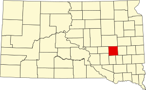
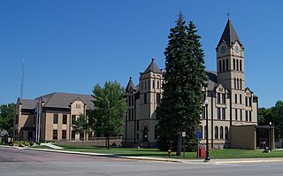
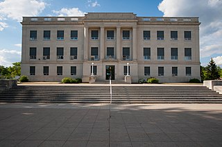
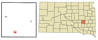
Beadle County is a county in the U.S. state of South Dakota. As of the 2020 census, the population was 19,149, making it the 11th most populous county in South Dakota. Its county seat is Huron. The county was created in 1879 and organized in 1880. Beadle County comprises the Huron, SD Micropolitan Statistical Area.

<span class="mw-page-title-main">Aurora County, South Dakota</span> County in South Dakota, United States

Aurora County is a county in the U.S. state of South Dakota. As of the 2020 census, the population was 2,747. The county was created in 1879, and was organized in 1881.

<span class="mw-page-title-main">Barnes County, North Dakota</span> County in North Dakota, United States

Barnes County is a county in the U.S. state of North Dakota. As of the 2020 census, the population was 10,853. Its county seat is Valley City.

<span class="mw-page-title-main">Webster, South Dakota</span> City in South Dakota, United States

Webster is a city in and the county seat of Day County, South Dakota, United States. The population was 1,728 at the 2020 census.

<span class="mw-page-title-main">Lennox, South Dakota</span> City in South Dakota, United States

Lennox is a city in Lincoln County, South Dakota, United States, located 20 miles (32 km) southwest of Sioux Falls. The population was 2,423 at the 2020 census.

<span class="mw-page-title-main">Howard, South Dakota</span> City in South Dakota, United States

Howard is a city in Miner County, South Dakota, United States. The population was 848 at the 2020 census. It is the county seat and most populous city in Miner County.

<span class="mw-page-title-main">Dell Rapids, South Dakota</span> City in South Dakota, United States

Dell Rapids is a city in Minnehaha County, South Dakota, United States. The population was 3,996 at the 2020 census. It is known as "The Little City with the Big Attractions."

<span class="mw-page-title-main">Letcher, South Dakota</span> Town in South Dakota, United States

Letcher is a town in Sanborn County, South Dakota, United States. The population was 159 at the 2020 census.

<span class="mw-page-title-main">Woonsocket, South Dakota</span> City in South Dakota, United States

Woonsocket is a city in Sanborn County, South Dakota. The population was 631 at the 2020 census. It is the county seat of Sanborn County.

<span class="mw-page-title-main">Elk Point, South Dakota</span> City in South Dakota, United States

Elk Point is a city in and county seat of Union County, South Dakota, United States. The population was 2,149 as of the 2020 census.

<span class="mw-page-title-main">Box Elder, South Dakota</span> City in South Dakota, United States

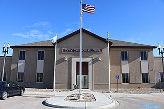
Box Elder is a city in Pennington and Meade counties in the State of South Dakota. The population was 11,746 at the 2020 census, making it the 11th most populous city in South Dakota. Ellsworth Air Force Base lies on the northeast side of the city.

References

  1. 1 2 "State & County QuickFacts". United States Census Bureau. Retrieved March 20, 2024.
  2. "Find a County". National Association of Counties. Retrieved June 7, 2011.
  3. History of SD Counties/Sanborn (accessed February 8, 2019)
  4. 1 2 3 Sanborn County SD Google Maps (accessed February 8, 2019)
  5. ""Find an Altitude" Google Maps (accessed February 8, 2019)". Archived from the original on May 21, 2019. Retrieved February 8, 2019.
  6. "2010 Census Gazetteer Files". United States Census Bureau. August 22, 2012. Retrieved March 28, 2015.
  7. "County Population Totals and Components of Change: 2020-2023" . Retrieved March 17, 2024.
  8. "U.S. Decennial Census". United States Census Bureau. Retrieved March 28, 2015.
  9. "Historical Census Browser". University of Virginia Library. Retrieved March 28, 2015.
  10. Forstall, Richard L., ed. (March 27, 1995). "Population of Counties by Decennial Census: 1900 to 1990". United States Census Bureau. Retrieved March 28, 2015.
  11. "Census 2000 PHC-T-4. Ranking Tables for Counties: 1990 and 2000" (PDF). United States Census Bureau. April 2, 2001. Archived (PDF) from the original on October 9, 2022. Retrieved March 28, 2015.
  12. "US Census Bureau, Table P16: Household Type". United States Census Bureau. Retrieved March 20, 2024.
  13. Leip, David. "Atlas of US Presidential Elections". uselectionatlas.org. Retrieved April 15, 2018.
  14. "2020 CENSUS - SCHOOL DISTRICT REFERENCE MAP: Sanborn County, SD" (PDF). U.S. Census Bureau . Retrieved April 10, 2024. - Text list

44°02′N98°05′W / 44.03°N 98.09°W / 44.03; -98.09