Tea, South Dakota

Last updated

Tea, South Dakota
Motto: 
"Tea...A Growing Tradition"
Lincoln County South Dakota Incorporated and Unincorporated areas Tea Highlighted.svg
Location in Lincoln County and the state of South Dakota
Coordinates: 43°27′20″N96°49′26″W / 43.45556°N 96.82389°W / 43.45556; -96.82389
CountryUnited States
State South Dakota
County Lincoln
Founded1894 [1]
Government
  Type Mayor-council government
   Mayor Casey Voelker
  City AdministratorDan Zulkosky
Area
[2]
  Total1.53 sq mi (3.96 km2)
  Land1.53 sq mi (3.96 km2)
  Water0.00 sq mi (0.00 km2)
Elevation
[3]
1,490 ft (450 m)
Population
 (2020) [4]
  Total5,598
  Density3,658.82/sq mi (1,413.64/km2)
Time zone UTC-6 (CST)
  Summer (DST) UTC-5 (CDT)
ZIP code
57064
Area code 605
FIPS code 46-63100
GNIS feature ID1267599 [3]
Website teasd.com

Tea is a city in Lincoln County, South Dakota, United States and is a suburb of Sioux Falls. The population was 5,598 at the 2020 census. [5]

Contents

Tea was laid out in 1894. [6] The name "Tea" was selected on account of its brevity. [7]

Geography

According to the United States Census Bureau, the city has a total area of 1.69 square miles (4.38 km2), all land. [8]

Demographics

Historical population
CensusPop.Note
1910 134
1920 16523.1%
1930 148−10.3%
1940 16511.5%
1950 151−8.5%
1960 18824.5%
1970 30260.6%
1980 729141.4%
1990 7867.8%
2000 1,742121.6%
2010 3,806118.5%
2020 5,59847.1%
2021 (est.)6,256 [9] 11.8%
U.S. Decennial Census [10]
2020 Census [5] [4]

2010 census

As of the census of 2010, there were 3,806 people, 1,254 households, and 1,009 families living in the city. The population density was 2,252.1 inhabitants per square mile (869.5/km2). There were 1,354 housing units at an average density of 801.2 per square mile (309.3/km2). The racial makeup of the city was 96.9% White, 0.7% African American, 0.1% Native American, 0.1% Asian, 0.3% from other races, and 1.9% from two or more races. Hispanic or Latino of any race were 1.3% of the population.

There were 1,254 households, of which 59.1% had children under the age of 18 living with them, 63.2% were married couples living together, 12.6% had a female householder with no husband present, 4.7% had a male householder with no wife present, and 19.5% were non-families. 14.0% of all households were made up of individuals, and 2.2% had someone living alone who was 65 years of age or older. The average household size was 3.04 and the average family size was 3.35.

The median age in the city was 27.7 years. 37.5% of residents were under the age of 18; 7.6% were between the ages of 18 and 24; 38.3% were from 25 to 44; 13.9% were from 45 to 64; and 3% were 65 years of age or older. The gender makeup of the city was 50.6% male and 49.4% female.

2000 census

As of the census of 2000, there were 1,742 people, 590 households, and 489 families living in the city. The population density was 2,877.8 inhabitants per square mile (1,111.1/km2). There were 600 housing units at an average density of 991.2 per square mile (382.7/km2). The racial makeup of the city was 96.67% White, 0.40% African American, 0.34% Native American, 0.34% Asian, 0.06% Pacific Islander, 0.40% from other races, and 1.78% from two or more races. Hispanic or Latino of any race were 0.86% of the population.

There were 590 households, out of which 55.6% had children under the age of 18 living with them, 67.3% were married couples living together, 12.7% had a female householder with no husband present, and 17.1% were non-families. 13.1% of all households were made up of individuals, and 2.2% had someone living alone who was 65 years of age or older. The average household size was 2.95 and the average family size was 3.23.

In the city, the population was spread out, with 36.2% under the age of 18, 7.3% from 18 to 24, 40.8% from 25 to 44, 12.5% from 45 to 64, and 3.2% who were 65 years of age or older. The median age was 28 years. For every 100 females, there were 98.4 males. For every 100 females age 18 and over, there were 94.9 males.

As of 2000 the median income for a household in the city was $50,671, and the median income for a family was $52,297. Males had a median income of $32,734 versus $23,860 for females. The per capita income for the city was $17,719. About 2.1% of families and 3.1% of the population were below the poverty line, including 3.8% of those under age 18 and 5.8% of those age 65 or over.

Education

Tea Public Schools are part of the Tea Area School District. The Tea Area School District has three elementary schools, one middle school, and one high school. Students attend Tea Area High School. [11]

Parks

Tea contains three recreational areas: Tea Athletic Complex, Howling Ridge Park, and Prairie Trails Park. [12]

Related Research Articles

<span class="mw-page-title-main">Dakota City, Iowa</span> City in Iowa, United States

Dakota City is a city in and the county seat of Humboldt County, Iowa, United States. The population was 759 at the time of the 2020 census. Dakota City shares its western border with the much larger city of Humboldt. It is the least populous county seat in Iowa.

<span class="mw-page-title-main">Minnewaukan, North Dakota</span> City in North Dakota, United States

Minnewaukan is a city in Benson County, North Dakota, United States. It serves as the county seat and is fourth largest city in the county, after Fort Totten, Leeds, and Maddock. The population was 199 at the 2020 census. Minnewaukan was founded in 1884.

<span class="mw-page-title-main">Lansford, North Dakota</span> City in North Dakota, United States

Lansford is a city in Bottineau County, North Dakota, United States. The population was 238 at the 2020 census. Lansford was founded in 1903.

<span class="mw-page-title-main">Page, North Dakota</span> City in North Dakota, United States

Page is a city in Cass County, North Dakota, United States. The population was 190 at the 2020 census. Page was founded in 1882.

<span class="mw-page-title-main">Munich, North Dakota</span> City in North Dakota, United States

Munich is a city in Cavalier County, North Dakota, United States. The population was 190 at the 2020 census. The city was named after Munich, Germany.

<span class="mw-page-title-main">Gackle, North Dakota</span> City in North Dakota, United States

Gackle is a town in Logan County, North Dakota, United States. The population was 281 at the 2020 census.

<span class="mw-page-title-main">Velva, North Dakota</span> City in North Dakota, United States

Velva is a city in McHenry County, North Dakota, United States. Part of the Minot Micropolitan Statistical Area, it was founded in 1897 and the population was 1,086 at the 2020 census. Southeast of Minot, Velva is at the southernmost point of the Souris River.

<span class="mw-page-title-main">Plaza, North Dakota</span> City in North Dakota, United States

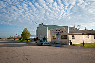
Plaza is a city in Mountrail County, North Dakota, United States. The population was 211 at the 2020 census. Plaza was founded in 1906. The business district is built around a central town square, city park or "plaza". A key feature of the plaza is a recently completed large covered gazebo.

<span class="mw-page-title-main">Pekin, North Dakota</span> City in North Dakota, United States

Pekin is a city in Nelson County, North Dakota, United States. The population was 75 at the 2020 census. The first European settlers immigrated to the area in the mid-19th century and Pekin was founded in 1906.

<span class="mw-page-title-main">Taylor, North Dakota</span> City in North Dakota, United States

Taylor is a city in Stark County, North Dakota, United States. The population was 230 at the 2020 census. It is part of the Dickinson Micropolitan Statistical Area.

<span class="mw-page-title-main">Pisek, North Dakota</span> City in North Dakota, United States

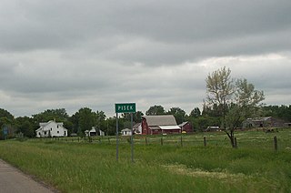
Pisek is a city in Walsh County, North Dakota, United States. The population was 89 at the 2020 census.

<span class="mw-page-title-main">Waubay, South Dakota</span> City in South Dakota, United States

Waubay is a city in Day County, South Dakota, United States. The population was 473 at the 2020 census.

<span class="mw-page-title-main">Freeman, South Dakota</span> City in South Dakota, United States

Freeman is a city in Hutchinson County, South Dakota, United States. The population was 1,329 at the 2020 census.

<span class="mw-page-title-main">Parkston, South Dakota</span> City in South Dakota, United States

Parkston is a city in Hutchinson County, South Dakota, United States. The population was 1,567 at the 2020 census.

<span class="mw-page-title-main">Presho, South Dakota</span> City in South Dakota, United States

Presho is a small city in Lyman County, South Dakota, United States. The population was 472 at the 2020 census.

<span class="mw-page-title-main">Britton, South Dakota</span> City in South Dakota, United States

Britton is a city in and the county seat of Marshall County, South Dakota, United States. The population was 1,215 at the 2020 census.

<span class="mw-page-title-main">Dell Rapids, South Dakota</span> City in South Dakota, United States

Dell Rapids is a city in Minnehaha County, South Dakota, United States. The population was 3,996 at the 2020 census. It is known as "The Little City with the Big Attractions."

<span class="mw-page-title-main">Wilmot, South Dakota</span> City in South Dakota, United States

Wilmot is a city in Roberts County, South Dakota, United States. The population was 432 at the 2020 census.

<span class="mw-page-title-main">Iroquois, South Dakota</span> City in South Dakota, United States

Iroquois is a city on the border of Beadle and Kingsbury counties in South Dakota, United States. The population was 292 at the 2020 census. The school building is located in Kingsbury County, while the school parking lot is located in Beadle County. Highway 14 runs directly through Iroquois.

<span class="mw-page-title-main">Eagle Butte, South Dakota</span> City in South Dakota, United States

Eagle Butte is a city in Dewey and Ziebach counties in South Dakota, United States. The population was 1,258 at the 2020 census.

References

  1. "SD Towns" (PDF). South Dakota State Historical Society . Retrieved February 16, 2010.
  2. "ArcGIS REST Services Directory". United States Census Bureau. Retrieved October 15, 2022.
  3. 1 2 U.S. Geological Survey Geographic Names Information System: Tea, South Dakota
  4. 1 2 "Census Population API". United States Census Bureau. Retrieved October 15, 2022.
  5. 1 2 "Explore Census Data". United States Census Bureau . Retrieved August 16, 2022.
  6. Federal Writers' Project (1940). South Dakota place-names, v.1-3. American guide series. University of South Dakota. p. 63.
  7. Moyer, Armond; Moyer, Winifred (1958). The origins of unusual place-names. Keystone Pub. Associates. p. 129.
  8. "US Gazetteer files 2010". United States Census Bureau. Archived from the original on January 12, 2012. Retrieved June 21, 2012.
  9. "City and Town Population Totals: 2020-2021". United States Census Bureau. June 24, 2022. Retrieved August 16, 2022.
  10. United States Census Bureau. "Census of Population and Housing" . Retrieved September 23, 2013.
  11. "Tea Area School District". Tea Area School District. Retrieved August 5, 2012.
  12. "Tea Parks". teasd.com. Retrieved April 19, 2018.