Todd County, South Dakota

Last updated

Todd County
St. Charles Borromeo church (St. Francis SD) from S 1.JPG
Map of South Dakota highlighting Todd County.svg
Location within the U.S. state of South Dakota
South Dakota in United States.svg
South Dakota's location within the U.S.
Coordinates: 43°11′N100°44′W / 43.18°N 100.73°W / 43.18; -100.73
CountryFlag of the United States.svg United States
StateFlag of South Dakota.svg  South Dakota
Founded1909 [1]
Named for John Blair Smith Todd
Seat None (de jure)
Winner (de facto)
Largest city Mission
Area
  Total1,391 sq mi (3,600 km2)
  Land1,389 sq mi (3,600 km2)
  Water2.3 sq mi (6 km2)  0.2%
Population
 (2020)
  Total9,319
  Estimate 
(2023)
9,199 Decrease2.svg
  Density6.7/sq mi (2.6/km2)
Time zone UTC−6 (Central)
  Summer (DST) UTC−5 (CDT)
Congressional district At-large
Winner in neighboring Tripp County serves as Todd County's administrative center.

Todd County is a county in the U.S. state of South Dakota. As of the 2020 census, the population was 9,319. [2] Todd County does not have its own county seat. Instead, Winner in neighboring Tripp County serves as its administrative center. [3] Its largest city is Mission. The county was created in 1909, although it remains unorganized. [1] [4] The county was named for John Blair Smith Todd, a delegate from Dakota Territory to the United States House of Representatives [1] and a Civil War general.

Contents

The county lies entirely within the Rosebud Indian Reservation and is coterminous with the main reservation (exclusive of off-reservation trust lands, which lie in four nearby counties). Its southern border is with the state of Nebraska. It is one of five South Dakota counties entirely within an Indian reservation. [5] The county's per-capita income makes it the third poorest county in the United States. Unlike many rural counties in South Dakota, since 1960, its net population has increased.

History

Until 1981 Todd, Shannon (now Oglala Lakota), and Washabaugh were the last unorganized counties in the United States. Although then organized, Todd did not receive a home rule charter until 1983. It contracts with Tripp County for its Auditor, Treasurer, and Registrar of Deeds. [6]

Geography

Todd County lies on the south line of South Dakota. Its south boundary line abuts the north boundary line of the state of Nebraska. Its terrain consists of semi-arid rolling hills, cut by gullies and drainages which flow to the northeast. The land is partially dedicated to agriculture, including center pivot irrigation. [7] The terrain slopes to the northeast, and its highest point is near the SW corner, at 3,176 ft (968 m) ASL. [8]

The eastern portion of South Dakota's counties (48 of 66) observe Central Time; the western counties (18 of 66) observe Mountain Time. Todd County is the westernmost of the SD counties to observe Central Time. [9]

Todd County has a total area of 1,391 square miles (3,600 km2), of which 1,389 square miles (3,600 km2) is land and 2.3 square miles (6.0 km2) (0.2%) is water. [10]

Major highways

Adjacent counties

Protected areas [7]

Lakes [7]

Demographics

Historical population
CensusPop.Note
1910 2,164
1920 2,78428.7%
1930 5,898111.9%
1940 5,714−3.1%
1950 4,758−16.7%
1960 4,661−2.0%
1970 6,60641.7%
1980 7,32810.9%
1990 8,35214.0%
2000 9,0508.4%
2010 9,6126.2%
2020 9,319−3.0%
2023 (est.)9,199 [11] −1.3%
U.S. Decennial Census [12]
1790-1960 [13] 1900-1990 [14]
1990-2000 [15] 2010-2020 [2]

2020 census

As of the 2020 census, there were 9,319 people, 2,570 households, and 1,889 families residing in the county. [16] The population density was 6.7 inhabitants per square mile (2.6/km2). There were 2,875 housing units.

2010 census

As of the 2010 census, there were 9,612 people, 2,780 households, and 2,091 families in the county. The population density was 6.9 inhabitants per square mile (2.7/km2). There were 3,142 housing units at an average density of 2.3 units per square mile (0.89 units/km2). The racial makeup of the county was 88.1% American Indian, 9.6% white, 0.2% black or African American, 0.2% Asian, 0.2% from other races, and 1.8% from two or more races. Those of Hispanic or Latino origin made up 2.4% of the population. In terms of ancestry, 5.1% were German, and 1.1% were American.

Of the 2,780 households, 55.9% had children under the age of 18 living with them, 28.5% were married couples living together, 34.7% had a female householder with no husband present, 24.8% were non-families, and 21.1% of all households were made up of individuals. The average household size was 3.45 and the average family size was 3.95. The median age was 24.0 years.

The median income for a household in the county was $25,196 and the median income for a family was $29,010. Males had a median income of $26,971 versus $30,211 for females. The per capita income for the county was $11,010. About 44.2% of families and 48.8% of the population were below the poverty line, including 59.0% of those under age 18 and 45.7% of those age 65 or over.

Communities

City

Town

Census-designated places

Other unincorporated communities [7]

  • Grass Mountain
  • HeDog
  • Hidden Timber
  • Olsonville

Unorganized territories

Politics

Todd County heavily leans Democratic in politics. Similar to most other Native American-majority counties, Hillary Clinton won the majority of votes in Todd County in 2016. In 2020, Joe Biden received a larger majority of the county vote. The last election in which the Republican nominee won the county was in 1960 which the Richard Nixon-Henry Cabot Lodge Jr. ticket carried the county.

United States presidential election results for Todd County, South Dakota [17]
Year Republican Democratic Third party
No.%No.%No.%
2020 53220.95%1,96377.31%441.73%
2016 48722.92%1,50570.82%1336.26%
2012 49819.94%1,97679.13%230.92%
2008 57120.19%2,20878.08%491.73%
2004 88925.23%2,54372.16%922.61%
2000 47831.99%99366.47%231.54%
1996 48224.21%1,38069.31%1296.48%
1992 45627.98%91556.13%25915.89%
1988 53531.92%1,11766.65%241.43%
1984 67939.61%1,02259.63%130.76%
1980 80341.76%97250.55%1487.70%
1976 58340.66%82657.60%251.74%
1972 80646.78%90752.64%100.58%
1968 68338.78%98756.05%915.17%
1964 72336.20%1,27463.80%00.00%
1960 90950.14%90449.86%00.00%
1956 74847.31%83352.69%00.00%
1952 1,02562.65%61137.35%00.00%
1948 62543.46%79655.35%171.18%
1944 73751.90%68348.10%00.00%
1940 1,24550.14%1,23849.86%00.00%
1936 62431.74%1,31867.04%241.22%
1932 53326.20%1,48573.01%160.79%
1928 78948.43%83151.01%90.55%
1924 83767.01%23718.98%17514.01%

See also

Related Research Articles

<span class="mw-page-title-main">Ziebach County, South Dakota</span> County in South Dakota, United States

Ziebach County is a county in the U.S. state of South Dakota. As of the 2020 census, the population was 2,413. Its county seat is Dupree. It is the last county in the United States alphabetically.

<span class="mw-page-title-main">Walworth County, South Dakota</span> County in South Dakota, United States

Walworth County is a county in the U.S. state of South Dakota. As of the 2020 census, the population was 5,315. Its county seat is Selby. The county was created in 1873 and organized in 1883. It is named for Walworth County, Wisconsin.

<span class="mw-page-title-main">Tripp County, South Dakota</span> County in South Dakota, United States

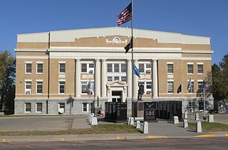
Tripp County is a county in the U.S. state of South Dakota. As of the 2020 census, the population was 5,624. Its county seat is Winner. The county was created in 1873, and was organized in 1909. It is named for lawyer, judge, and diplomat Bartlett Tripp.

<span class="mw-page-title-main">Oglala Lakota County, South Dakota</span> County in South Dakota, United States

Oglala Lakota County is a county in southwestern South Dakota, United States. As of the 2020 census, the population was 13,672. Oglala Lakota County does not have a functioning county seat; Hot Springs in neighboring Fall River County serves as its administrative center. The county was created as a part of the Dakota Territory in 1875, although it remains unorganized. Its largest community is Pine Ridge.

<span class="mw-page-title-main">Mellette County, South Dakota</span> County in South Dakota, United States

Mellette County is a county in the U.S. state of South Dakota. As of the 2020 census, the population was 1,918. Its county seat is White River. The county was created in 1909, and was organized in 1911. It was named for Arthur C. Mellette, the last Governor of the Dakota Territory and the first Governor of the state of South Dakota.

<span class="mw-page-title-main">Jones County, South Dakota</span> County in South Dakota, United States

Jones County is a county in the U.S. state of South Dakota. As of the 2020 census, the population was 917, making it the least populous county in South Dakota. Its county seat is Murdo. Created in 1916 and organized in 1917, it is the most recently established county in South Dakota. It was named after Granville Whittington Jones, an Arkansas-born clergyman/lawyer, who moved to Chamberlain, SD and became a noted Chautauqua speaker.

<span class="mw-page-title-main">Jackson County, South Dakota</span> County in South Dakota, United States

Jackson County is a county in the U.S. state of South Dakota. As of the 2020 census, the population was 2,806. Its county seat is Kadoka. The county was created in 1883, and was organized in 1915. Washabaugh County was merged into Jackson County in 1983.

<span class="mw-page-title-main">Haakon County, South Dakota</span> County in South Dakota, United States

Haakon County is a county in the U.S. state of South Dakota. As of the 2020 census, the population was 1,872. Its county seat is Philip.

<span class="mw-page-title-main">Gregory County, South Dakota</span> County in South Dakota, United States

Gregory County is a county in the U.S. state of South Dakota. As of the 2020 census, the population was 3,994. Its county seat is Burke. The county was created in 1862 and organized in 1898. It was named for the politician J. Shaw Gregory.

<span class="mw-page-title-main">Dewey County, South Dakota</span> County in South Dakota, United States

Dewey County is a county in the U.S. state of South Dakota. As of the 2020 census, the population was 5,239. Its county seat is Timber Lake. The county was created in 1883 and organized in 1910. It was named for William P. Dewey, Territorial surveyor-general from 1873 to 1877.

<span class="mw-page-title-main">Corson County, South Dakota</span> County in South Dakota, United States

Corson County is a county in the U.S. state of South Dakota. As of the 2020 census, the population was 3,902. Its county seat is McIntosh. The county was named for Dighton Corson, a native of Maine, who came to the Black Hills in 1876, and in 1877 began practicing law at Deadwood.

<span class="mw-page-title-main">Bennett County, South Dakota</span> County in South Dakota, United States

Bennett County is a county in the U.S. state of South Dakota. As of the 2020 census, the population was 3,381. Its county seat is Martin. The county lies completely within the exterior boundary of the Pine Ridge Indian Reservation. To the east is the Rosebud Indian Reservation, occupied by Sicangu Oyate, also known the Upper Brulé Sioux Nation and the Rosebud Sioux Tribe (RST), a branch of the Lakota people.

<span class="mw-page-title-main">Sioux County, North Dakota</span> County in North Dakota, United States

Sioux County is a county located along the southern border of the U.S. state of North Dakota. As of the 2020 census, the population was 3,898. Its eastern border is the Missouri River and its county seat is Fort Yates.

<span class="mw-page-title-main">Keya Paha County, Nebraska</span> County in Nebraska, United States

Keya Paha County is a county in the U.S. state of Nebraska. As of the 2020 United States Census, the population was 769. Its county seat is Springview.

<span class="mw-page-title-main">Cherry County, Nebraska</span> County in Nebraska, United States

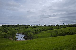
Cherry County is a county located in the U.S. state of Nebraska. As of the 2020 United States Census, the population was 5,455. Its county seat is Valentine. The county was named for Lt. Samuel A. Cherry, an Army officer who was stationed at Fort Niobrara and who had been killed in South Dakota in 1881. Cherry County is in the Nebraska Sandhills. It is the largest county in the state at nearly 6,000 square miles (16,000 km2), larger than the state of Connecticut.

<span class="mw-page-title-main">Marty, South Dakota</span> CDP in South Dakota, United States

Marty is a census-designated place (CDP) in southern Charles Mix County, South Dakota, United States. The population was 677 at the 2020 census.

<span class="mw-page-title-main">Tripp, South Dakota</span> City in South Dakota, United States

Tripp is a city in Hutchinson County, South Dakota, United States. The population was 575 in the 2020 census.

<span class="mw-page-title-main">Mission, South Dakota</span> City in South Dakota, United States

Mission is a city on the Rosebud Indian Reservation in northern Todd County, South Dakota, United States. The population was 1,156 at the 2020 census.

<span class="mw-page-title-main">Rosebud, South Dakota</span> CDP in South Dakota, United States

Rosebud also Sicanġu is a census-designated place (CDP) in Todd County, South Dakota, United States. The population was 1,455 at the 2020 census.

<span class="mw-page-title-main">Winner, South Dakota</span> City in South Dakota, United States

Winner is a city in central Tripp County, South Dakota, United States. The population was 2,921 at the 2020 census. It is the county seat of Tripp County. Winner also serves as the administrative center of neighboring Todd County, which does not have its own county seat. The nearest airport is Winner Regional Airport.

References

  1. 1 2 3 Legislative Manual, South Dakota, 2005, p. 597
  2. 1 2 "State & County QuickFacts". United States Census Bureau. Retrieved March 20, 2024.
  3. "Find a County". National Association of Counties. Retrieved June 7, 2011.
  4. "Dakota Territory, South Dakota, and North Dakota: Individual County Chronologies". Dakota Territory Atlas of Historical County Boundaries. The Newberry Library. 2006. Archived from the original on April 2, 2018. Retrieved March 31, 2015.
  5. The other counties are Corson, Dewey, Oglala Lakota, and Ziebach.
  6. Archived February 17, 2012, at the Wayback Machine , Reference Desk/South Dakota Counties (accessed April 19, 2009).
  7. 1 2 3 4 5 "Todd County · South Dakota". Google Maps. Retrieved April 27, 2024.
  8. 1 2 ""Find an Altitude" Google Maps (accessed February 4, 2019)". Archived from the original on May 21, 2019. Retrieved February 4, 2019.
  9. Map of Time Zone Line through South Dakota (accessed January 30, 2019)
  10. "2010 Census Gazetteer Files". United States Census Bureau. August 22, 2012. Retrieved March 28, 2015.
  11. "County Population Totals and Components of Change: 2020-2023" . Retrieved March 17, 2024.
  12. "U.S. Decennial Census". United States Census Bureau. Retrieved March 28, 2015.
  13. "Historical Census Browser". University of Virginia Library. Retrieved March 28, 2015.
  14. Forstall, Richard L., ed. (March 27, 1995). "Population of Counties by Decennial Census: 1900 to 1990". United States Census Bureau. Retrieved March 28, 2015.
  15. "Census 2000 PHC-T-4. Ranking Tables for Counties: 1990 and 2000" (PDF). United States Census Bureau. April 2, 2001. Archived (PDF) from the original on October 9, 2022. Retrieved March 28, 2015.
  16. "US Census Bureau, Table P16: Household Type". United States Census Bureau. Retrieved March 20, 2024.
  17. Leip, David. "Atlas of US Presidential Elections". uselectionatlas.org. Retrieved April 15, 2018.

43°11′N100°44′W / 43.18°N 100.73°W / 43.18; -100.73