Artesian, South Dakota

Last updated

Artesian, South Dakota
Sanborn County South Dakota Incorporated and Unincorporated areas Artesian Highlighted.svg
Location in Sanborn County and the state of South Dakota
Coordinates: 44°00′28″N97°55′25″W / 44.00778°N 97.92361°W / 44.00778; -97.92361
Country United States
State South Dakota
County Sanborn
Incorporated1914 [1]
Area
[2]
  Total0.55 sq mi (1.43 km2)
  Land0.55 sq mi (1.43 km2)
  Water0.00 sq mi (0.00 km2)
Elevation
[3]
1,316 ft (401 m)
Population
 (2020) [4]
  Total129
  Density232.85/sq mi (89.92/km2)
Time zone UTC-6 (Central (CST))
  Summer (DST) UTC-5 (CDT)
ZIP code
57314
Area code 605
FIPS code 46-02380 [5]
GNIS feature ID1267270 [3]
Website http://www.artesiansd.com/

Artesian is a town in Sanborn County, South Dakota, United States. The population was 129 at the 2020 census. [6]

Contents

History

When the first settlement at Artesian was made in 1883, it was called "Diana". [7] A post office called Diana was established in 1883, the name was changed to Denton, and then to Artesian City in 1887, and again to Artesian in 1889. [8] The present name is for the artesian aquifer and artesian wells near the original town site. [7] [9]

Geography

According to the United States Census Bureau, the town has a total area of 0.55 square miles (1.42 km2), all land. [10]

Demographics

Historical population
CensusPop.Note
1890 256
1900 33932.4%
1910 58372.0%
1920 68918.2%
1930 556−19.3%
1940 502−9.7%
1950 429−14.5%
1960 330−23.1%
1970 277−16.1%
1980 227−18.1%
1990 217−4.4%
2000 157−27.6%
2010 138−12.1%
2020 129−6.5%
U.S. Decennial Census [4]

2010 census

As of the census [11] of 2010, there were 138 people, 73 households, and 42 families residing in the town. The population density was 250.9 inhabitants per square mile (96.9/km2). There were 96 housing units at an average density of 174.5 per square mile (67.4/km2). The racial makeup of the town was 89.9% White, 0.7% Asian, 3.6% from other races, and 5.8% from two or more races. Hispanic or Latino of any race were 5.8% of the population.

There were 73 households, of which 19.2% had children under the age of 18 living with them, 39.7% were married couples living together, 11.0% had a female householder with no husband present, 6.8% had a male householder with no wife present, and 42.5% were non-families. 41.1% of all households were made up of individuals, and 23.3% had someone living alone who was 65 years of age or older. The average household size was 1.89 and the average family size was 2.45.

The median age in the town was 47 years. 14.5% of residents were under the age of 18; 7.9% were between the ages of 18 and 24; 23.1% were from 25 to 44; 34.1% were from 45 to 64; and 20.3% were 65 years of age or older. The gender makeup of the town was 52.2% male and 47.8% female.

2000 census

As of the census [5] of 2000, there were 157 people, 70 households, and 42 families residing in the town. The population density was 285.7 inhabitants per square mile (110.3/km2). There were 99 housing units at an average density of 180.2 per square mile (69.6/km2). The racial makeup of the town was 100% White. Five of the people in the town call themselves Hispanic or Latino.

There were 70 households, out of which 24.3% had children under the age of 18 living with them, 54.3% were married couples living together, 2.9% had a female householder with no husband present, and 38.6% were non-families. 34.3% of all households were made up of individuals, and 15.7% had someone living alone who was 65 years of age or older. The average household size was 2.24 and the average family size was 2.93.

In the town, the population was spread out, with 19.7% under the age of 18, 8.9% from 18 to 24, 24.2% from 25 to 44, 24.2% from 45 to 64, and 22.9% who were 65 years of age or older. The median age was 43 years. For every 100 females, there were 121.1 males. For every 100 females age 18 and over, there were 117.2 males.

The median income for a household in the town was $36,875, and the median income for a family was $43,750. Males had a median income of $22,500 versus $23,125 for females. The per capita income for the town was $15,392. None of the families and 5.6% of the population were living below the poverty line, including no under eighteens and 27.3% of those over 64.

Related Research Articles

<span class="mw-page-title-main">Sheldon, North Dakota</span> City in North Dakota, United States

Sheldon is a city in Ransom County, North Dakota, United States. The population was 95 at the 2020 census. Sheldon was founded in 1882.

<span class="mw-page-title-main">Wolsey, South Dakota</span> Town in South Dakota, United States

Wolsey is a town in Beadle County, South Dakota, United States. The population was 459 at the 2020 census.

<span class="mw-page-title-main">Bushnell, South Dakota</span> Town in South Dakota, United States

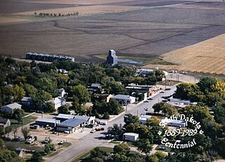
Bushnell is a town in Brookings County, South Dakota, United States. The population was 71 at the 2020 census.

<span class="mw-page-title-main">Mound City, South Dakota</span> Town in South Dakota, United States

Mound City is a town in and the county seat of Campbell County, South Dakota, United States. The population was 69 at the 2020 census.

<span class="mw-page-title-main">Bradley, South Dakota</span> Town in South Dakota, United States

Bradley is a town in Clark County, South Dakota, United States. The population was 65 at the 2020 census.

<span class="mw-page-title-main">Wallace, South Dakota</span> Town in South Dakota, United States

Wallace is a town in Codington County, South Dakota, United States. The population was 91 at the 2020 census. It is part of the Watertown, South Dakota Micropolitan Statistical Area.

<span class="mw-page-title-main">Fairburn, South Dakota</span> Town in South Dakota, United States

Fairburn is a town in Custer County, South Dakota, United States. The population was 60 at the 2020 census.

<span class="mw-page-title-main">Pierpont, South Dakota</span> Town in South Dakota, United States

Pierpont is a town in northwestern Day County, South Dakota, United States. The population was 129 at the 2020 census.

<span class="mw-page-title-main">Isabel, South Dakota</span> Town in South Dakota, United States

Isabel is a town in Dewey County, South Dakota, United States. The population was 145 at the 2020 census.

<span class="mw-page-title-main">Revillo, South Dakota</span> Town in South Dakota, United States

Revillo is a town in southeastern Grant County, South Dakota, United States. The population was 99 at the 2020 census.

<span class="mw-page-title-main">Stockholm, South Dakota</span> Town in South Dakota, United States

Stockholm is a town in Grant County, South Dakota, United States. The population was 102 at the 2020 census.

<span class="mw-page-title-main">Alpena, South Dakota</span> Town in South Dakota, United States

Alpena is a town in northeastern corner of Jerauld County, South Dakota, United States. The population was 286 at the 2010 census.

<span class="mw-page-title-main">Ramona, South Dakota</span> Town in South Dakota, United States

Ramona is a town in Lake County, South Dakota, United States. The population was 159 at the 2020 census.

<span class="mw-page-title-main">Wentworth, South Dakota</span> Village in South Dakota, United States

Wentworth is an incorporated village in Lake County, South Dakota, United States. It is the only incorporated village in the state of South Dakota. The population was 181 at the 2020 census.

<span class="mw-page-title-main">Crooks, South Dakota</span> City in South Dakota, United States

Crooks is a city in Minnehaha County, South Dakota, United States and is a suburb of Sioux Falls. The population was 1,362 at the 2020 census. Crooks was named New Hope until 1904. The town's present name honors W. A. Crooks, a local politician.

<span class="mw-page-title-main">Corona, South Dakota</span> Town in South Dakota, United States

Corona is a town in Roberts County, South Dakota, United States. The population was 69 at the 2020 census.

<span class="mw-page-title-main">Woonsocket, South Dakota</span> City in South Dakota, United States

Woonsocket is a city in Sanborn County, South Dakota. The population was 631 at the 2020 census. It is the county seat of Sanborn County.

<span class="mw-page-title-main">Ashton, South Dakota</span> City in South Dakota, United States

Ashton is a city in eastern Spink County, South Dakota, United States. The population was 108 at the 2020 census.

<span class="mw-page-title-main">Davis, South Dakota</span> Town in South Dakota, United States

Davis is a town in Turner County, South Dakota, United States. The population was 54 at the 2020 census.

<span class="mw-page-title-main">Lesterville, South Dakota</span> Town in South Dakota, United States

Lesterville is a town in Yankton County, South Dakota, United States. The population was 115 at the 2020 census.

References

  1. "SD Towns" (PDF). South Dakota State Historical Society. Archived from the original (PDF) on February 10, 2010. Retrieved February 10, 2010.
  2. "ArcGIS REST Services Directory". United States Census Bureau. Retrieved October 15, 2022.
  3. 1 2 U.S. Geological Survey Geographic Names Information System: Artesian, South Dakota
  4. 1 2 "Census Population API". United States Census Bureau. Retrieved October 15, 2022.
  5. 1 2 "U.S. Census website". United States Census Bureau . Retrieved January 31, 2008.
  6. "U.S. Census Bureau: Artesian town, South Dakota". www.census.gov. United States Census Bureau. Retrieved January 28, 2022.
  7. 1 2 Federal Writers' Project (1940). South Dakota place-names, v.1-3. University of South Dakota. p. 23.
  8. "Sanborn County". Jim Forte Postal History. Retrieved January 22, 2015.
  9. Moyer, Armond; Moyer, Winifred (1958). The origins of unusual place-names. Keystone Pub. Associates. p. 9.
  10. "US Gazetteer files 2010". United States Census Bureau. Archived from the original on January 25, 2012. Retrieved June 21, 2012.
  11. "U.S. Census website". United States Census Bureau . Retrieved June 21, 2012.