Estelline, South Dakota

Last updated

Estelline, South Dakota
Hamlin County South Dakota Incorporated and Unincorporated areas Estelline Highlighted.svg
Location in Hamlin County and the state of South Dakota
Coordinates: 44°34′34″N96°54′2″W / 44.57611°N 96.90056°W / 44.57611; -96.90056
Country United States
State South Dakota
County Hamlin
Incorporated1920 [1]
Area
[2]
  Total0.94 sq mi (2.45 km2)
  Land0.94 sq mi (2.45 km2)
  Water0.00 sq mi (0.00 km2)
Elevation
1,654 ft (504 m)
Population
 (2020) [3]
  Total749
  Density792.59/sq mi (305.87/km2)
Time zone UTC-6 (Central (CST))
  Summer (DST) UTC-5 (CDT)
ZIP code
57234
Area code 605
FIPS code 46-19980 [4]
GNIS feature ID1254960 [5]
Website www.estellinesd.com

Estelline is a city in Hamlin County, South Dakota, United States. It is part of the Watertown, South Dakota Micropolitan Statistical Area. The population was 749 at the 2020 census. [6] The current mascot for Estelline High School is the Redhawks.

Contents

History

A post office was first established at Estelline in 1879. [7] Estelline was platted in 1882. [8] [9] The city was named for a local farmer's daughter. [8]

Geography

Estelline is located at 44°34′34″N96°54′02″W / 44.576213°N 96.900469°W / 44.576213; -96.900469 . [10]

According to the United States Census Bureau, the city has a total area of 0.95 square miles (2.46 km2), all of it land. [11]

Estelline has been assigned the ZIP code 57234 and the FIPS place code 19980.

Demographics

Historical population
CensusPop.Note
1890 210
1900 35770.0%
1910 50942.6%
1920 65829.3%
1930 488−25.8%
1940 62728.5%
1950 76021.2%
1960 722−5.0%
1970 624−13.6%
1980 71915.2%
1990 658−8.5%
2000 6752.6%
2010 76813.8%
2020 749−2.5%
U.S. Decennial Census [12] [3]

2010 census

At the 2010 census there were 768 people in 297 households, including 189 families, in the city. The population density was 808.4 inhabitants per square mile (312.1/km2). There were 321 housing units at an average density of 337.9 per square mile (130.5/km2). The racial makup of the city was 93.1% White, 0.7% Native American, 5.2% from other races, and 1.0% from two or more races. Hispanic or Latino of any race were 6.3%. [13]

Of the 297 households 30.0% had children under the age of 18 living with them, 47.5% were married couples living together, 9.1% had a female householder with no husband present, 7.1% had a male householder with no wife present, and 36.4% were non-families. 31.3% of households were one person and 15.8% were one person aged 65 or older. The average household size was 2.40 and the average family size was 2.98.

The median age was 40.9 years. 25.8% of residents were under the age of 18; 6.6% were between the ages of 18 and 24; 21.7% were from 25 to 44; 19% were from 45 to 64; and 26.8% were 65 or older. The gender makeup of the city was 47.3% male and 52.7% female.

2000 census

At the 2000 census there were 675 people in 290 households, including 173 families, in the city. The population density was 703.8 inhabitants per square mile (271.7/km2). There were 311 housing units at an average density of 324.3 per square mile (125.2/km2). The racial makup of the city was 98.67% White, 0.74% Native American, 0.15% Asian, and 0.44% from two or more races. Hispanic or Latino of any race were 1.48%. [4] 32.1% were of German, 22.0% Norwegian, 8.7% Irish, 6.8% American and 5.3% Dutch ancestry according to Census 2000.

Of the 290 households 24.1% had children under the age of 18 living with them, 53.8% were married couples living together, 3.8% had a female householder with no husband present, and 40.3% were non-families. 37.2% of households were one person and 21.4% were one person aged 65 or older. The average household size was 2.13 and the average family size was 2.82.

The age distribution was 21.2% under the age of 18, 3.9% from 18 to 24, 22.1% from 25 to 44, 18.5% from 45 to 64, and 34.4% 65 or older. The median age was 48 years. For every 100 females, there were 91.8 males. For every 100 females age 18 and over, there were 84.7 males.

The median household income was $27,679 and the median family income was $36,250. Males had a median income of $28,393 versus $22,222 for females. The per capita income for the city was $14,967. About 4.4% of families and 12.7% of the population were below the poverty line, including 9.7% of those under age 18 and 22.2% of those age 65 or over.

Related Research Articles

<span class="mw-page-title-main">Hamlin County, South Dakota</span> County in South Dakota, United States

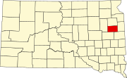
Hamlin County is a county in the U.S. state of South Dakota. As of the 2020 census, the population was 6,164. Its county seat is Hayti. The county was created in 1873 and organized in 1878. It was named for Hannibal Hamlin, Lincoln's first vice-president.

<span class="mw-page-title-main">Grand River, Iowa</span> City in Iowa, United States

Grand River is a city in northwest Decatur County, Iowa, United States. The population was 196 at the time of the 2020 census.

<span class="mw-page-title-main">Van Wert, Iowa</span> City in Iowa, United States

Van Wert is a city in northern Decatur County, Iowa, United States. The population was 178 at the time of the 2020 census.

<span class="mw-page-title-main">St. Marys, Iowa</span> City in Iowa, United States

St. Marys or Saint Marys is a city in Warren County, Iowa, United States. The population was 108 at the time of the 2020 census.

<span class="mw-page-title-main">West Chester, Iowa</span> City in Iowa, United States

West Chester is a city in Washington County, Iowa, United States. It is part of the Iowa City, Iowa Metropolitan Statistical Area. The population was 144 at the time of the 2020 census.

<span class="mw-page-title-main">Kensett, Iowa</span> City in Iowa, United States

Kensett is a city in Worth County, Iowa, United States. The population was 257 at the time of the 2020 census. It is part of the Mason City Micropolitan Statistical Area.

<span class="mw-page-title-main">Aldrich, Minnesota</span> City in Minnesota, United States

Aldrich is a city in Wadena County, Minnesota, United States, along the Partridge River. The population was 48 at the 2010 census. The small community holds the distinction as the first permanent settlement in Wadena County and the first to establish a post office. It is also home to the first Catholic church in the area, established in 1870, as a mission church.

<span class="mw-page-title-main">Valley City, North Dakota</span> City in North Dakota, United States

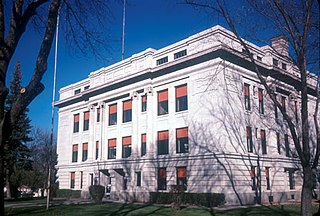
Valley City is a city in Barnes County, North Dakota, United States. It is the county seat of Barnes County. The population was 6,575 during the 2020 census, making it the 12th largest city in North Dakota. Valley City was founded in 1874.

<span class="mw-page-title-main">Regan, North Dakota</span> City in North Dakota, United States

Regan is a city in Burleigh County, North Dakota, United States. Its population was 35 at the 2020 census. Regan was founded in 1912.

<span class="mw-page-title-main">Wing, North Dakota</span> City in North Dakota, United States

Wing is a rural small town in Burleigh County, North Dakota, United States. It is part of the "Bismarck, ND Metropolitan Statistical Area" or "Bismarck-Mandan". The population was 132 at the 2020 census. As of 2010, the town has a post office, a full service station, a bar, a restaurant, a small (10-unit) apartment complex, a senior's center, a hotel, several churches, and a complete (K-12) public school system.

<span class="mw-page-title-main">Dunn Center, North Dakota</span> City in North Dakota, United States

Dunn Center is a city in Dunn County, North Dakota, United States. The population was 227 at the 2020 census. Dunn Center was founded in 1914.

<span class="mw-page-title-main">Dwight, North Dakota</span> City in North Dakota, United States

Dwight is a city in Richland County, North Dakota, United States. The population was 80 at the 2020 census. Dwight was founded in 1881. It is part of the Wahpeton, ND–MN Micropolitan Statistical Area.

<span class="mw-page-title-main">Rolette, North Dakota</span> City in North Dakota, United States

Rolette is a city in Rolette County, North Dakota, United States. The population was 484 at the 2020 census.

<span class="mw-page-title-main">Finley, North Dakota</span> City in North Dakota, United States

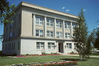
Finley is a city in Steele County, North Dakota. It is the county seat of Steele County. The population was 401 at the 2020 census. Finley was founded in 1897.

<span class="mw-page-title-main">Cleveland, North Dakota</span> City in North Dakota, United States

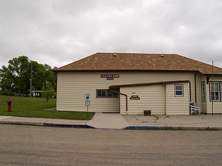
Cleveland is a city in Stutsman County, North Dakota, United States. The population was 57 at the 2020 census.

<span class="mw-page-title-main">Berthold, North Dakota</span> City in North Dakota, United States

Berthold is a town in Ward County, North Dakota, United States. The population was 490 at the 2020 census.

<span class="mw-page-title-main">Bryant, South Dakota</span> City in South Dakota, United States

Bryant is a city in Hamlin County, South Dakota, United States. It is part of the Watertown, South Dakota Micropolitan Statistical Area. The population was 471 at the 2020 census. The mayor is named Win Noem.

<span class="mw-page-title-main">Whitewood, South Dakota</span> City in South Dakota, United States

Whitewood is a city in Lawrence County, South Dakota, United States. The population was 879 at the 2020 census.

<span class="mw-page-title-main">Veblen, South Dakota</span> City in South Dakota, United States

Veblen is a city in Marshall County, South Dakota, United States. The population was 317 at the 2020 census.

<span class="mw-page-title-main">Hurley, South Dakota</span> City in South Dakota, United States

Hurley is a city in Turner County, South Dakota, United States. The population was 379 at the 2020 census.

References

  1. "SD Towns" (PDF). South Dakota State Historical Society. Archived from the original (PDF) on February 10, 2010. Retrieved February 11, 2010.
  2. "ArcGIS REST Services Directory". United States Census Bureau. Retrieved October 15, 2022.
  3. 1 2 "Census Population API". United States Census Bureau. Retrieved October 15, 2022.
  4. 1 2 "U.S. Census website". United States Census Bureau . Retrieved January 31, 2008.
  5. "US Board on Geographic Names". United States Geological Survey. October 25, 2007. Retrieved January 31, 2008.
  6. "U.S. Census Bureau: Estelline city, South Dakota". www.census.gov. United States Census Bureau. Retrieved June 27, 2022.
  7. "Hamlin County". Jim Forte Postal History. Archived from the original on April 2, 2015. Retrieved March 17, 2015.
  8. 1 2 Chicago and North Western Railway Company (1908). A History of the Origin of the Place Names Connected with the Chicago & North Western and Chicago, St. Paul, Minneapolis & Omaha Railways. p. 69.
  9. Federal Writers' Project (1940). South Dakota place-names, v.1-3. University of South Dakota. p. 37.
  10. "US Gazetteer files: 2010, 2000, and 1990". United States Census Bureau. February 12, 2011. Retrieved April 23, 2011.
  11. "US Gazetteer files 2010". United States Census Bureau. Archived from the original on January 25, 2012. Retrieved June 21, 2012.
  12. United States Census Bureau. "Census of Population and Housing" . Retrieved June 12, 2016.
  13. "U.S. Census website". United States Census Bureau . Retrieved June 21, 2012.