Virgil, South Dakota

Last updated

Virgil, South Dakota
Beadle County South Dakota Incorporated and Unincorporated areas Virgil Highlighted.svg
Location in Beadle County and the state of South Dakota
Coordinates: 44°17′27″N98°25′39″W / 44.29083°N 98.42750°W / 44.29083; -98.42750
Country United States
State South Dakota
County Beadle
Incorporated1916 [1]
Area
[2]
  Total1.00 sq mi (2.59 km2)
  Land1.00 sq mi (2.59 km2)
  Water0.00 sq mi (0.00 km2)
Elevation
[3]
1,335 ft (407 m)
Population
 (2020) [4]
  Total26
  Density26.00/sq mi (10.04/km2)
Time zone UTC-6 (Central (CST))
  Summer (DST) UTC-5 (CDT)
ZIP code
57379
Area code 605
FIPS code 46-67500 [5]
GNIS feature ID1267617 [3]

Virgil is a town in Beadle County in the U.S. state of South Dakota. The population was 26 at the 2020 census. [6]

Contents

History

Virgil got its start in the early 1880s when the railroad was extended to that point. [7] The town was named for the Ancient Roman poet Virgil. [8]

Geography

According to the United States Census Bureau, the town has a total area of 1.00 square mile (2.59 km2), all land. [9]

Demographics

Historical population
CensusPop.Note
1920 189
1930 166−12.2%
1940 145−12.7%
1950 124−14.5%
1960 81−34.7%
1970 43−46.9%
1980 37−14.0%
1990 33−10.8%
2000 25−24.2%
2010 16−36.0%
2020 2662.5%
U.S. Decennial Census [10] [4]

2010 census

As of the census [11] of 2010, there were 16 people, 9 households, and 5 families residing in the town. The population density was 16.0 inhabitants per square mile (6.2/km2). There were 14 housing units at an average density of 14.0 per square mile (5.4/km2). The racial makeup of the town was 100.0% White.

There were 9 households, of which 11.1% had children under the age of 18 living with them, 55.6% were married couples living together, and 44.4% were non-families. 44.4% of all households were made up of individuals. The average household size was 1.78 and the average family size was 2.40.

The median age in the town was 52.5 years. 12.5% of residents were under the age of 18; 0.1% were between the ages of 18 and 24; 31.3% were from 25 to 44; 31.3% were from 45 to 64; and 25% were 65 years of age or older. The gender makeup of the town was 56.3% male and 43.8% female.

2000 census

As of the census [5] of 2000, there were 25 people, 13 households, and 7 families residing in the town. The population density was 25.0 people per square mile (9.7/km2). There were 15 housing units at an average density of 15.0 per square mile (5.8/km2). The racial makeup of the town was 100.00% White.

There were 13 households, out of which 23.1% had children under the age of 18 living with them, 53.8% were married couples living together, 7.7% had a female householder with no husband present, and 38.5% were non-families. 38.5% of all households were made up of individuals, and 15.4% had someone living alone who was 65 years of age or older. The average household size was 1.92 and the average family size was 2.50.

The town's population was distributed in the following way: 12.0% under the age of 18, 4.0% from 18 to 24, 36.0% from 25 to 44, 32.0% from 45 to 64, and 16.0% who were 65 years of age or older. The median age was 45 years. For every 100 females, there were 150.0 males. For every 100 females age 18 and over, there were 144.4 males.

The median income for a household in the town was $38,750, and the median income for a family was $38,750. Males had a median income of $26,250 versus $18,750 for females. The per capita income for the town was $23,226. None of the population and none of the families were below the poverty line.

Related Research Articles

<span class="mw-page-title-main">Hunter, North Dakota</span> City in North Dakota, United States

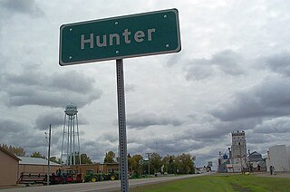
Hunter is a city in Cass County, North Dakota, United States. The population was 332 at the 2020 census. Hunter was founded in 1881.

<span class="mw-page-title-main">Leonard, North Dakota</span> City in North Dakota, United States

Leonard is a city in Cass County, North Dakota, United States. The population was 248 at the 2020 census. Leonard was founded in 1881.

<span class="mw-page-title-main">Deering, North Dakota</span> City in North Dakota, United States

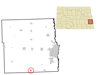
Deering is a City in McHenry County, North Dakota, United States. In addition to homes, there are a church, a bar, a combined country store and restaurant, an auto body shop, an agricultural supplies outfit, and a set of free-standing gas pumps. The population was 94 at the 2020 census. It is part of the Minot Micropolitan Statistical Area. Deering was founded in 1903.

<span class="mw-page-title-main">Voltaire, North Dakota</span> City in North Dakota, United States

Voltaire is a city in McHenry County, North Dakota, United States. The population was 46 at the 2020 census. It is part of the Minot Micropolitan Statistical Area.

<span class="mw-page-title-main">Wolford, North Dakota</span> City in North Dakota, United States

Wolford is a city in Pierce County, North Dakota, United States. The population was 43 at the 2020 census. Wolford was founded in 1905.

<span class="mw-page-title-main">Cayuga, North Dakota</span> City in North Dakota, United States

Cayuga is a city in Sargent County, North Dakota, United States. It sits on the banks of the Wild Rice River. The population was 40 at the 2020 census. Cayuga was founded in 1887.

<span class="mw-page-title-main">Cavour, South Dakota</span> Town in South Dakota, United States

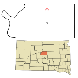
Cavour is a town in Beadle County, South Dakota, United States. The population was 128 at the 2020 census.

<span class="mw-page-title-main">Mound City, South Dakota</span> Town in South Dakota, United States

Mound City is a town in and the county seat of Campbell County, South Dakota, United States. The population was 69 at the 2020 census.

<span class="mw-page-title-main">Platte, South Dakota</span> City in South Dakota, United States

Platte is a city in Charles Mix County, South Dakota, United States. The population was 1,311 at the 2022 census. The community is named after the Platte Creek, a tributary of the Missouri River reservoir Lake Francis Case. Platte is located 15 miles east of Lake Francis Case on the Missouri River.

<span class="mw-page-title-main">Garden City, South Dakota</span> Town in South Dakota, United States

Garden City is a town in Clark County, South Dakota, United States. The population was 33 at the 2020 census.

<span class="mw-page-title-main">Wakonda, South Dakota</span> Town in South Dakota, United States

Wakonda is a town in Clay County, South Dakota, United States. The population was 347 at the 2020 census.

<span class="mw-page-title-main">Florence, South Dakota</span> Town in South Dakota, United States

Florence is a town in northwestern Codington County, South Dakota, United States. It is part of the Watertown, South Dakota Micropolitan Statistical Area. The population was 337 at the 2020 census.

<span class="mw-page-title-main">Onaka, South Dakota</span> Town in South Dakota, United States

Onaka is a town in Faulk County, South Dakota, United States. The population was 13 at the 2020 census.

<span class="mw-page-title-main">Lake City, South Dakota</span> Town in South Dakota, United States

Lake City is a town in Marshall County, South Dakota, United States. The population was 45 at the 2020 census. Fort Sisseton Historic State Park, whose fort is listed on the National Register of Historic Places, is located nearby.

<span class="mw-page-title-main">Langford, South Dakota</span> Town in South Dakota, United States

Langford is a town in Marshall County, South Dakota, United States. The population was 283 at the 2020 census.

<span class="mw-page-title-main">Roswell, South Dakota</span> Census-designated place in South Dakota, United States

Roswell is a CDP in Miner County, South Dakota, United States. The population was 8 at the 2020 census. It disincorporated as a town in 2012.

<span class="mw-page-title-main">Crooks, South Dakota</span> City in South Dakota, United States

Crooks is a city in Minnehaha County, South Dakota, United States and is a suburb of Sioux Falls. The population was 1,362 at the 2020 census. Crooks was named New Hope until 1904. The town's present name honors W. A. Crooks, a local politician.

<span class="mw-page-title-main">Sherman, South Dakota</span> Town in South Dakota, United States

Sherman is a town in Minnehaha County, South Dakota, United States. The population was 81 at the 2020 census.

<span class="mw-page-title-main">Hoven, South Dakota</span> Town in South Dakota, United States

Hoven is a town in Potter County, South Dakota, United States. The population was 379 at the 2020 census.

<span class="mw-page-title-main">Agar, South Dakota</span> Town in South Dakota, United States

Agar is a small town in Sully County, South Dakota, United States. The population was 76 as of the 2010 census. Agar is a farm/ranch service center.

References

  1. "SD Towns" (PDF). South Dakota State Historical Society . Retrieved February 16, 2010.
  2. "ArcGIS REST Services Directory". United States Census Bureau. Retrieved October 15, 2022.
  3. 1 2 U.S. Geological Survey Geographic Names Information System: Virgil, South Dakota
  4. 1 2 "Census Population API". United States Census Bureau. Retrieved October 15, 2022.
  5. 1 2 "U.S. Census website". United States Census Bureau . Retrieved January 31, 2008.
  6. "U.S. Census Bureau: Virgil town, South Dakota". www.census.gov. United States Census Bureau. Retrieved February 5, 2022.
  7. Federal Writers' Project (1940). South Dakota place-names, v.1-3. University of South Dakota. p. 65.
  8. "Profile for Virgil, South Dakota". ePodunk . Retrieved June 4, 2014.
  9. "US Gazetteer files 2010". United States Census Bureau. Archived from the original on July 2, 2012. Retrieved June 21, 2012.
  10. "Census of Population and Housing". Census.gov. Retrieved June 4, 2015.
  11. "U.S. Census website". United States Census Bureau . Retrieved June 21, 2012.