Davis, South Dakota

Last updated

Davis, South Dakota
Turner County South Dakota Incorporated and Unincorporated areas Davis Highlighted.svg
Location in Turner County and the state of South Dakota
Coordinates: 43°15′29″N97°00′07″W / 43.25806°N 97.00194°W / 43.25806; -97.00194
Country United States
State South Dakota
County Turner
Incorporated1896 [1]
Government
  TypeMayor Council
  MayorGracie Dose
Area
[2]
  Total0.43 sq mi (1.11 km2)
  Land0.43 sq mi (1.11 km2)
  Water0.00 sq mi (0.00 km2)
Elevation
[3]
1,250 ft (380 m)
Population
 (2020) [4]
  Total54
  Density125.58/sq mi (48.51/km2)
Time zone UTC-6 (Central (CST))
  Summer (DST) UTC-5 (CDT)
ZIP code
57021
Area code 605
FIPS code 46-15540 [5]
GNIS feature ID1267349 [3]

Davis is a town in Turner County, South Dakota, United States. The population was 54 at the 2020 census. [6]

Contents

Davis was laid out in 1893, and named for a first settler. [7]

Geography

According to the United States Census Bureau, the town has a total area of 0.43 square miles (1.11 km2), all land. [8]

Demographics

Historical population
CensusPop.Note
1900 151
1910 1648.6%
1920 24549.4%
1930 209−14.7%
1940 23010.0%
1950 153−33.5%
1960 124−19.0%
1970 101−18.5%
1980 100−1.0%
1990 87−13.0%
2000 10419.5%
2010 85−18.3%
2020 54−36.5%
U.S. Decennial Census [9] [4]

2010 census

As of the census [10] of 2010, there were 85 people, 41 households, and 24 families residing in the town. The population density was 197.7 inhabitants per square mile (76.3/km2). There were 51 housing units at an average density of 118.6 per square mile (45.8/km2). The racial makeup of the town was 100.0% White.

There were 41 households, of which 22.0% had children under the age of 18 living with them, 51.2% were married couples living together, 2.4% had a female householder with no husband present, 4.9% had a male householder with no wife present, and 41.5% were non-families. 34.1% of all households were made up of individuals, and 9.8% had someone living alone who was 65 years of age or older. The average household size was 2.07 and the average family size was 2.58.

The median age in the town was 48.5 years. 16.5% of residents were under the age of 18; 4.7% were between the ages of 18 and 24; 21.2% were from 25 to 44; 41.2% were from 45 to 64; and 16.5% were 65 years of age or older. The gender makeup of the town was 49.4% male and 50.6% female.

2000 census

As of the census [5] of 2000, there were 104 people, 49 households, and 29 families residing in the town. The population density was 238.2 inhabitants per square mile (92.0/km2). There were 55 housing units at an average density of 126.0 per square mile (48.6/km2). The racial makeup of the town was 98.08% White, and 1.92% from two or more races.

There were 49 households, out of which 16.3% had children under the age of 18 living with them, 57.1% were married couples living together, 2.0% had a female householder with no husband present, and 40.8% were non-families. 36.7% of all households were made up of individuals, and 18.4% had someone living alone who was 65 years of age or older. The average household size was 2.12 and the average family size was 2.83.

In the town, the population was spread out, with 20.2% under the age of 18, 9.6% from 18 to 24, 19.2% from 25 to 44, 33.7% from 45 to 64, and 17.3% who were 65 years of age or older. The median age was 46 years. For every 100 females, there were 103.9 males. For every 100 females age 18 and over, there were 107.5 males.

The median income for a household in the town was $32,813, and the median income for a family was $46,250. Males had a median income of $26,458 versus $21,250 for females. The per capita income for the town was $17,112. None of the population or families were below the poverty line.

Related Research Articles

<span class="mw-page-title-main">Minnewaukan, North Dakota</span> City in North Dakota, United States

Minnewaukan is a city in Benson County, North Dakota, United States. It serves as the county seat and is fourth largest city in the county, after Fort Totten, Leeds, and Maddock. The population was 199 at the 2020 census. Minnewaukan was founded in 1884.

<span class="mw-page-title-main">Goodrich, North Dakota</span> City in North Dakota, United States

Goodrich is a city in Sheridan County, North Dakota, United States. The population was 106 at the 2020 census. Goodrich was founded in 1901.

<span class="mw-page-title-main">Wolsey, South Dakota</span> Town in South Dakota, United States

Wolsey is a town in Beadle County, South Dakota, United States. The population was 459 at the 2020 census.

<span class="mw-page-title-main">Stratford, South Dakota</span> Town in South Dakota, United States

Stratford is a town in southern Brown County, South Dakota, United States. The population was 57 at the 2020 census.

<span class="mw-page-title-main">Westport, South Dakota</span> Town in South Dakota, United States

Westport is a town in western Brown County, South Dakota, United States. The population was 88 at the 2020 census.

<span class="mw-page-title-main">Ravinia, South Dakota</span> Town in South Dakota, United States

Ravinia is a town in Charles Mix County, South Dakota, United States. The population was 71 at the 2020 census.

<span class="mw-page-title-main">Wagner, South Dakota</span> City in South Dakota, United States

Wagner is a city in Charles Mix County, South Dakota, United States. The population was 1,490 at the 2020 census. The city is served by Wagner Municipal Airport as well as YST Transit buses.

<span class="mw-page-title-main">Bradley, South Dakota</span> Town in South Dakota, United States

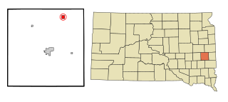
Bradley is a town in Clark County, South Dakota, United States. The population was 65 at the 2020 census.

<span class="mw-page-title-main">Andover, South Dakota</span> Town in South Dakota, United States

Andover is a town in northwestern Day County, South Dakota, United States. The population was 66 at the 2020 census.

<span class="mw-page-title-main">Isabel, South Dakota</span> Town in South Dakota, United States

Isabel is a town in Dewey County, South Dakota, United States. The population was 145 at the 2020 census.

<span class="mw-page-title-main">Revillo, South Dakota</span> Town in South Dakota, United States

Revillo is a town in southeastern Grant County, South Dakota, United States. The population was 99 at the 2020 census.

<span class="mw-page-title-main">Stockholm, South Dakota</span> Town in South Dakota, United States

Stockholm is a town in Grant County, South Dakota, United States. The population was 102 at the 2020 census.

<span class="mw-page-title-main">Olivet, South Dakota</span> Town in South Dakota, United States

Olivet is a town in and the county seat of Hutchinson County, South Dakota. The population was 64 at the time of the 2020 census.

<span class="mw-page-title-main">Nunda, South Dakota</span> Town in South Dakota, United States

Nunda is a village in Lake County, South Dakota, United States. The population was 46 at the 2020 census. Located there are a post office, grainery, bar and grill, and an American Legion post.

<span class="mw-page-title-main">Hudson, South Dakota</span> Town in South Dakota, United States

Hudson is a town in Lincoln County, South Dakota, United States. The population was 311 at the 2020 census. It is the easternmost community in South Dakota.

<span class="mw-page-title-main">Eden, South Dakota</span> Town in South Dakota, United States

Eden is a town in Marshall County, South Dakota, United States. The population was 94 at the 2020 census.

<span class="mw-page-title-main">Lake City, South Dakota</span> Town in South Dakota, United States

Lake City is a town in Marshall County, South Dakota, United States. The population was 45 at the 2020 census. Fort Sisseton Historic State Park, whose fort is listed on the National Register of Historic Places, is located nearby.

<span class="mw-page-title-main">Crooks, South Dakota</span> City in South Dakota, United States

Crooks is a city in Minnehaha County, South Dakota, United States and is a suburb of Sioux Falls. The population was 1,362 at the 2020 census. Crooks was named New Hope until 1904. The town's present name honors W. A. Crooks, a local politician.

<span class="mw-page-title-main">Corona, South Dakota</span> Town in South Dakota, United States

Corona is a town in Roberts County, South Dakota, United States. The population was 69 at the 2020 census.

<span class="mw-page-title-main">Peever, South Dakota</span> Town in South Dakota, United States

Peever is a town in Roberts County, South Dakota, United States. The population was 180 at the 2020 census.

References

  1. "SD Towns" (PDF). South Dakota State Historical Society. Archived from the original (PDF) on February 10, 2010. Retrieved February 11, 2010.
  2. "ArcGIS REST Services Directory". United States Census Bureau. Retrieved October 15, 2022.
  3. 1 2 U.S. Geological Survey Geographic Names Information System: Davis, South Dakota
  4. 1 2 "Census Population API". United States Census Bureau. Retrieved October 15, 2022.
  5. 1 2 "U.S. Census website". United States Census Bureau . Retrieved January 31, 2008.
  6. "U.S. Census Bureau: Davis town, South Dakota". www.census.gov. United States Census Bureau. Retrieved March 11, 2022.
  7. Federal Writers' Project (1940). South Dakota place-names, v.1-3. University of South Dakota. p. 32. Archived from the original on April 15, 2022.
  8. "US Gazetteer files 2010". United States Census Bureau. Archived from the original on January 25, 2012. Retrieved June 21, 2012.
  9. "Census of Population and Housing". Census.gov. Retrieved June 4, 2015.
  10. "U.S. Census website". United States Census Bureau . Retrieved June 21, 2012.