Centerville, South Dakota

Last updated

Centerville
Centerville, South Dakota
Motto: 
"Where YOU Make a Difference"
Turner County South Dakota Incorporated and Unincorporated areas Centerville Highlighted.svg
Location in Turner County and the state of South Dakota
Coordinates: 43°07′00″N96°57′34″W / 43.11667°N 96.95944°W / 43.11667; -96.95944
Country United States
State South Dakota
County Turner
Incorporated1894 [1]
Government
  MayorAbbey Rotter
Area
[2]
  Total0.72 sq mi (1.86 km2)
  Land0.72 sq mi (1.86 km2)
  Water0.00 sq mi (0.00 km2)
Elevation
[3]
1,227 ft (374 m)
Population
 (2020) [4]
  Total918
  Density1,275.00/sq mi (492.60/km2)
Time zone UTC-6 (Central (CST))
  Summer (DST) UTC-5 (CDT)
ZIP code
57014
Area code 605
FIPS code 46-11060 [5]
GNIS feature ID1267316 [3]
Website City of Centerville

Centerville is a city in Turner County, South Dakota, United States. The population was 918 at the 2020 census. [6] Centerville is part of the Sioux Falls, South Dakota metropolitan area.

Contents

History

Centerville was platted in 1883. [7] It was named due to its location between Parker and Vermillion. [7]

One of the most powerful tornadoes in the 2003 South Dakota tornado outbreak was located around Centerville and was rated an F-2 on the Fujita scale. It had maximum winds of 135 miles per hour and caused damage in the town of Centerville and surrounding areas. No fatalities were reported with this tornado. Along with the F-2 tornado that was reported, 19 other tornadoes touched down within a 50-mile radius of Centerville.

Geography

According to the United States Census Bureau, the city has a total area of 0.72 square miles (1.86 km2), all land. [8]

Climate

Climate data for Centerville 6 SE, South Dakota (1991−2020 normals, extremes 1905−present)
MonthJanFebMarAprMayJunJulAugSepOctNovDecYear
Record high °F (°C)70
(21)
73
(23)
92
(33)
97
(36)
109
(43)
108
(42)
113
(45)
111
(44)
106
(41)
95
(35)
82
(28)
67
(19)
113
(45)
Mean maximum °F (°C)50.0
(10.0)
54.9
(12.7)
72.2
(22.3)
83.2
(28.4)
89.9
(32.2)
94.5
(34.7)
94.9
(34.9)
93.6
(34.2)
90.4
(32.4)
84.2
(29.0)
68.8
(20.4)
51.3
(10.7)
97.5
(36.4)
Mean daily maximum °F (°C)26.9
(−2.8)
31.9
(−0.1)
44.9
(7.2)
58.5
(14.7)
70.2
(21.2)
80.4
(26.9)
84.4
(29.1)
81.9
(27.7)
75.4
(24.1)
61.5
(16.4)
45.1
(7.3)
31.3
(−0.4)
57.7
(14.3)
Daily mean °F (°C)16.9
(−8.4)
21.4
(−5.9)
33.9
(1.1)
46.3
(7.9)
58.5
(14.7)
69.3
(20.7)
73.0
(22.8)
70.5
(21.4)
62.5
(16.9)
48.8
(9.3)
33.9
(1.1)
21.6
(−5.8)
46.4
(8.0)
Mean daily minimum °F (°C)6.8
(−14.0)
11.0
(−11.7)
22.9
(−5.1)
34.0
(1.1)
46.8
(8.2)
58.1
(14.5)
61.7
(16.5)
59.1
(15.1)
49.6
(9.8)
36.1
(2.3)
22.7
(−5.2)
12.0
(−11.1)
35.1
(1.7)
Mean minimum °F (°C)−16.3
(−26.8)
−10.5
(−23.6)
−0.1
(−17.8)
17.7
(−7.9)
32.2
(0.1)
45.2
(7.3)
48.9
(9.4)
46.4
(8.0)
32.4
(0.2)
18.8
(−7.3)
2.5
(−16.4)
−10.4
(−23.6)
−20.4
(−29.1)
Record low °F (°C)−44
(−42)
−35
(−37)
−21
(−29)
−6
(−21)
19
(−7)
33
(1)
38
(3)
32
(0)
19
(−7)
−6
(−21)
−20
(−29)
−39
(−39)
−44
(−42)
Average precipitation inches (mm)0.44
(11)
0.63
(16)
1.38
(35)
2.69
(68)
3.87
(98)
4.29
(109)
3.05
(77)
3.20
(81)
3.12
(79)
2.32
(59)
1.23
(31)
0.66
(17)
26.88
(683)
Average snowfall inches (cm)5.2
(13)
6.0
(15)
4.5
(11)
2.9
(7.4)
0.1
(0.25)
0.0
(0.0)
0.0
(0.0)
0.0
(0.0)
0.0
(0.0)
0.7
(1.8)
5.0
(13)
6.1
(15)
30.5
(77)
Average precipitation days (≥ 0.01 in)5.35.26.39.712.611.28.39.68.17.54.95.293.9
Average snowy days (≥ 0.1 in)4.84.22.81.60.10.00.00.00.00.52.44.320.7
Source: NOAA [9] [10]

Demographics

Historical population
CensusPop.Note
1890 723
1900 87120.5%
1910 97111.5%
1920 1,10413.7%
1930 1,1695.9%
1940 1,046−10.5%
1950 1,0530.7%
1960 887−15.8%
1970 9102.6%
1980 892−2.0%
1990 887−0.6%
2000 9102.6%
2010 882−3.1%
2020 9184.1%
U.S. Decennial Census [11] [4]

2010 census

As of the census [12] of 2010, there were 882 people, 374 households, and 231 families living in the city. The population density was 1,225.0 inhabitants per square mile (473.0/km2). There were 425 housing units at an average density of 590.3 per square mile (227.9/km2). The racial makeup of the city was 98.2% White, 0.3% African American, 0.6% Native American, 0.2% Asian, 0.1% from other races, and 0.6% from two or more races. Hispanic or Latino of any race were 1.2% of the population.

There were 374 households, of which 27.5% had children under the age of 18 living with them, 50.5% were married couples living together, 6.4% had a female householder with no husband present, 4.8% had a male householder with no wife present, and 38.2% were non-families. 34.2% of all households were made up of individuals, and 17.9% had someone living alone who was 65 years of age or older. The average household size was 2.27 and the average family size was 2.91.

The median age in the city was 39.9 years. 23.9% of residents were under the age of 18; 8% were between the ages of 18 and 24; 22.5% were from 25 to 44; 24.7% were from 45 to 64; and 20.9% were 65 years of age or older. The gender makeup of the city was 50.0% male and 50.0% female.

2000 census

As of the census [5] of 2000, there were 910 people, 387 households, and 236 families living in the city. The population density was 1,265.9 inhabitants per square mile (488.8/km2). There were 429 housing units at an average density of 596.8 per square mile (230.4/km2). The racial makeup of the city was 99.34% White, 0.11% Native American, 0.11% Asian, and 0.44% from two or more races. Hispanic or Latino of any race were 0.66% of the population.

There were 387 households, out of which 26.1% had children under the age of 18 living with them, 50.9% were married couples living together, 6.7% had a female householder with no husband present, and 38.8% were non-families. 35.4% of all households were made up of individuals, and 22.5% had someone living alone who was 65 years of age or older. The average household size was 2.23 and the average family size was 2.90.

In the city, the population was spread out, with 23.6% under the age of 18, 6.3% from 18 to 24, 22.2% from 25 to 44, 20.2% from 45 to 64, and 27.7% who were 65 years of age or older. The median age was 44 years. For every 100 females, there were 87.2 males. For every 100 females age 18 and over, there were 81.9 males.

The median income for a household in the city was $29,615, and the median income for a family was $39,643. Males had a median income of $27,171 versus $20,000 for females. The per capita income for the city was $17,089. About 4.2% of families and 8.2% of the population were below the poverty line, including 2.3% of those under age 18 and 19.1% of those age 65 or over.

Notable people

Related Research Articles

<span class="mw-page-title-main">Centerville, Indiana</span> Town in Indiana, United States

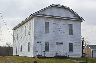
Centerville is a town in Center Township, Wayne County, in the U.S. state of Indiana. The population was 2,552 at the 2010 United States Census.

<span class="mw-page-title-main">Kearney, Missouri</span> City in Missouri, United States

Kearney is a city in Clay County, Missouri, United States. The population per the 2020 U.S. Census was 10,404. The city was the birthplace of Jesse James, and there is an annual festival in the third weekend of September to recognize the outlaw. It is part of the Kansas City metropolitan area.

<span class="mw-page-title-main">Centerville, Missouri</span> City in Missouri, United States

Centerville is a city in Reynolds County, Missouri, United States, situated along the West Fork of the Black River. The population was 167 at the 2020 census. It is the county seat of Reynolds County.

<span class="mw-page-title-main">Centerville, Minnesota</span> City in Minnesota, United States

Centerville is a city in Anoka County, Minnesota, United States. The population was 3,896 at the 2020 census.

<span class="mw-page-title-main">Oakes, North Dakota</span> City in North Dakota, United States

Oakes is the most populous city in Dickey County, North Dakota, United States. The population was 1,798 at the 2020 census. Oakes was founded in 1886.

<span class="mw-page-title-main">Northwood, North Dakota</span> City in North Dakota, United States

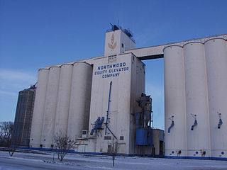
Northwood is a city in Grand Forks County, North Dakota, United States. It is part of the "Grand Forks, ND-MN Metropolitan Statistical Area" or "Greater Grand Forks." The population was 982 at the 2020 census.

<span class="mw-page-title-main">Elgin, North Dakota</span> City in North Dakota, United States

Elgin is a city in Grant County, North Dakota, United States. The population was 543 at the 2020 census.

<span class="mw-page-title-main">Centerville, Gallia County, Ohio</span> Village in Ohio, United States

Centerville, also known as Thurman, is a city in western Gallia County, Ohio, United States. The city lies adjacent to the Gallia - Jackson county line. It is located adjacent to U.S. Route 35 at the eastern terminus of State Route 279.

<span class="mw-page-title-main">Centerville, Ohio</span> City in Ohio, United States

Centerville is a city in Montgomery County, Ohio, United States. A core suburb of Metro Dayton, its population was 24,240 as of the 2020 census.

<span class="mw-page-title-main">Centerville, Washington County, Pennsylvania</span> Borough in Washington County, Pennsylvania, United States

Centerville is a borough in Washington County, Pennsylvania, United States. The population was 3,254 at the 2020 census.

<span class="mw-page-title-main">Timber Lake, South Dakota</span> City in South Dakota, United States

Timber Lake is a city in and the county seat of Dewey County, South Dakota, United States. The population was 509 at the 2020 census.

<span class="mw-page-title-main">Delmont, South Dakota</span> City in South Dakota, United States

Delmont is a city in southeastern Douglas County, South Dakota, United States. The population was 153 at the 2020 census.

<span class="mw-page-title-main">Bowdle, South Dakota</span> City in South Dakota, United States

Bowdle ( is a city in Edmunds County, South Dakota, United States. The population was 470 at the 2020 census.

<span class="mw-page-title-main">Gregory, South Dakota</span> City in South Dakota, United States

Gregory is a city in western Gregory County, South Dakota, United States. The population was 1,221 at the 2020 census.

<span class="mw-page-title-main">Castlewood, South Dakota</span> Town in South Dakota, United States

Castlewood is a city in Hamlin County, South Dakota, United States. It is part of the Watertown, South Dakota Micropolitan Statistical Area. The population was 698 at the 2020 census. and was estimated to be 707 in 2022.

<span class="mw-page-title-main">Wessington Springs, South Dakota</span> Town in South Dakota, United States

Wessington Springs is a town in central Jerauld County, South Dakota, United States. The population was 956 at the 2010 census. It is the county seat of Jerauld County.

<span class="mw-page-title-main">Spencer, South Dakota</span> City in South Dakota, United States

Spencer is a city in McCook County, South Dakota, United States. The population was 136 at the 2020 census. The city was almost destroyed by a violent F4 tornado on May 30, 1998 which killed six people.

<span class="mw-page-title-main">Howard, South Dakota</span> City in South Dakota, United States

Howard is a city in Miner County, South Dakota, United States. The population was 848 at the 2020 census. It is the county seat and most populous city in Miner County.

<span class="mw-page-title-main">Crooks, South Dakota</span> City in South Dakota, United States

Crooks is a city in Minnehaha County, South Dakota, United States and is a suburb of Sioux Falls. The population was 1,362 at the 2020 census. Crooks was named New Hope until 1904. The town's present name honors W. A. Crooks, a local politician.

<span class="mw-page-title-main">Woonsocket, South Dakota</span> City in South Dakota, United States

Woonsocket is a city in Sanborn County, South Dakota. The population was 631 at the 2020 census. It is the county seat of Sanborn County.

References

  1. "SD Towns" (PDF). South Dakota State Historical Society. Archived from the original (PDF) on February 10, 2010. Retrieved February 11, 2010.
  2. "ArcGIS REST Services Directory". United States Census Bureau. Retrieved October 15, 2022.
  3. 1 2 U.S. Geological Survey Geographic Names Information System: Centerville, South Dakota
  4. 1 2 "Census Population API". United States Census Bureau. Retrieved October 15, 2022.
  5. 1 2 "U.S. Census website". United States Census Bureau . Retrieved January 31, 2008.
  6. "U.S. Census Bureau: Centerville city, South Dakota". www.census.gov. United States Census Bureau. Retrieved March 11, 2022.
  7. 1 2 Chicago and North Western Railway Company (1908). A History of the Origin of the Place Names Connected with the Chicago & North Western and Chicago, St. Paul, Minneapolis & Omaha Railways. p. 54.
  8. "US Gazetteer files 2010". United States Census Bureau. Archived from the original on January 25, 2012. Retrieved June 21, 2012.
  9. "NowData - NOAA Online Weather Data". National Oceanic and Atmospheric Administration. Retrieved October 18, 2021.
  10. "Station: Centerville 6 SE, SD". U.S. Climate Normals 2020: U.S. Monthly Climate Normals (1991-2020). National Oceanic and Atmospheric Administration. Retrieved October 18, 2021.
  11. United States Census Bureau. "Census of Population and Housing" . Retrieved November 8, 2014.
  12. "U.S. Census website". United States Census Bureau . Retrieved June 21, 2012.
  13. Morton County Historical Society (1975). Peterson, Marion Plath (ed.). Morton prairie roots. Dallas, Texas: Taylor Publishing Co. p. 212. OCLC   2062977.