Pringle, South Dakota

Last updated

Pringle, South Dakota
Custer County South Dakota Incorporated and Unincorporated areas Pringle Highlighted.svg
Location in Custer County and the state of South Dakota
Coordinates: 43°36′32″N103°35′40″W / 43.60889°N 103.59444°W / 43.60889; -103.59444
Country United States
State South Dakota
County Custer
Area
[1]
  Total0.24 sq mi (0.63 km2)
  Land0.24 sq mi (0.63 km2)
  Water0.00 sq mi (0.00 km2)
Elevation
[2]
4,912 ft (1,497 m)
Population
 (2020) [3]
  Total109
  Density450.41/sq mi (173.56/km2)
Time zone UTC-7 (MST)
  Summer (DST) UTC-6 (MDT)
Zip Code
57773
Area code 605
FIPS code 46-51940 [4]
GNIS feature ID1267538 [2]

Pringle is a town in Custer County, South Dakota, United States. The population was 109 at the 2020 census. [5]

Contents

The town is named for W. H. Pringle, a cattleman who lived in the area. [6]

Geography

Pringle got its start as a stage stop on the Sidney-Custer Trail. Operated by Henry Pringle, it was called the Point of Rocks Stage Station, named after a prominent and distinct granite outcropping located due east of the current town.

The Sidney-Custer Trail was an important route into the southern Black Hills from Nebraska, and The Point of Rocks Station also served traffic between Cheyenne, Wyoming and Custer.

A small settlement, also called Point of Rocks, soon developed around the stage station. In 1890, the Chicago, Burlington, and Quincy Railroad track reached the settlement, at which time the town's name was changed to Pringle, named after Anna Carr Pringle, who provided hospitality to the railroad crews when they came through town. The settlement soon boasted a railroad depot and two stores. [7]

Pringle is most famous as the home of a housing complex devoted to the Fundamentalist Church of Jesus Christ of Latter Day Saints. The development continues to grow and spark controversy in the area. [8]

According to the United States Census Bureau, the town has a total area of 0.24 square miles (0.62 km2), all land. [9]

Demographics

Historical population
CensusPop.Note
1940 273
1950 193−29.3%
1960 145−24.9%
1970 86−40.7%
1980 10522.1%
1990 96−8.6%
2000 12530.2%
2010 112−10.4%
2020 109−2.7%
U.S. Decennial Census [10] [3]

2010 census

As of the census [11] of 2010, there were 112 people, 54 households, and 31 families living in the town. The population density was 466.7 inhabitants per square mile (180.2/km2). There were 68 housing units at an average density of 283.3 per square mile (109.4/km2). The racial makeup of the town was 93.8% White, 2.7% Native American, 1.8% from other races, and 1.8% from two or more races. Hispanic or Latino of any race were 3.6% of the population.

There were 54 households, of which 18.5% had children under the age of 18 living with them, 50.0% were married couples living together, 7.4% had a male householder with no wife present, and 42.6% were non-families. 33.3% of all households were made up of individuals, and 9.3% had someone living alone who was 65 years of age or older. The average household size was 2.07 and the average family size was 2.65.

The median age in the town was 45.5 years. 17% of residents were under the age of 18; 4.6% were between the ages of 18 and 24; 26.8% were from 25 to 44; 37.5% were from 45 to 64; and 14.3% were 65 years of age or older. The gender makeup of the town was 52.7% male and 47.3% female.

2000 census

As of the census [4] of 2000, there were 125 people, 46 households, and 36 families living in the town. The population density was 501.8 inhabitants per square mile (193.7/km2). There were 64 housing units at an average density of 256.9 per square mile (99.2/km2). The racial makeup of the town was 92.80% White, 2.40% Native American, 0.80% from other races, and 4.00% from two or more races. Hispanic or Latino of any race were 0.80% of the population.

There were 46 households, out of which 34.8% had children under the age of 18 living with them, 67.4% were married couples living together, 8.7% had a female householder with no husband present, and 21.7% were non-families. 19.6% of all households were made up of individuals, and 13.0% had someone living alone who was 65 years of age or older. The average household size was 2.72 and the average family size was 2.89.

In the town, the population was spread out, with 25.6% under the age of 18, 8.8% from 18 to 24, 29.6% from 25 to 44, 23.2% from 45 to 64, and 12.8% who were 65 years of age or older. The median age was 38 years. For every 100 females, there were 111.9 males. For every 100 females age 18 and over, there were 93.8 males.

The median income for a household in the town was $28,214, and the median income for a family was $28,571. Males had a median income of $25,625 versus $15,625 for females. The per capita income for the town was $10,584. There were 8.8% of families and 16.8% of the population living below the poverty line, including 7.1% of under eighteens and none of those over 64.

Related Research Articles

<span class="mw-page-title-main">Custer County, South Dakota</span> County in South Dakota, United States

Custer County is a county in the U.S. state of South Dakota. As of the 2020 census, the population was 8,318. Its county seat is Custer. The county was created in 1875, and was organized in 1877. It was named after General George Armstrong Custer.

<span class="mw-page-title-main">Thompson, North Dakota</span> City in North Dakota, United States

Thompson is a city in Grand Forks County, North Dakota, United States. It is part of the "Grand Forks, ND-MN Metropolitan Statistical Area" or "Greater Grand Forks". It is located on the border of Allendale and Walle townships, with Walle on the east and Allendale on the west. The population was 1,101 at the 2020 census. Thompson was founded in 1881.

<span class="mw-page-title-main">Hoople, North Dakota</span> City in North Dakota, United States

Hoople is a city in Walsh County, North Dakota, United States. The population was 247 at the 2020 census. Hoople, named for early settler Alan Hoople, was founded in 1889. Hoople's nickname is "Tater Town."

Custer City is a town in Custer County, Oklahoma, United States. Custer City is northeast of Clinton and northwest of Weatherford along Oklahoma 33. The population was 367 at the time of the 2020 census.

<span class="mw-page-title-main">Tabor, South Dakota</span> Town in South Dakota, United States

Tabor is a town in Bon Homme County, South Dakota, United States. The population was 407 at the 2020 census.

<span class="mw-page-title-main">Ravinia, South Dakota</span> Town in South Dakota, United States

Ravinia is a town in Charles Mix County, South Dakota, United States. The population was 71 at the 2020 census.

<span class="mw-page-title-main">Wagner, South Dakota</span> City in South Dakota, United States

Wagner is a city in Charles Mix County, South Dakota, United States. The population was 1,490 at the 2020 census. The city is served by Wagner Municipal Airport as well as YST Transit buses.

<span class="mw-page-title-main">Florence, South Dakota</span> Town in South Dakota, United States

Florence is a town in northwestern Codington County, South Dakota, United States. It is part of the Watertown, South Dakota Micropolitan Statistical Area. The population was 337 at the 2020 census.

<span class="mw-page-title-main">Buffalo Gap, South Dakota</span> Town in South Dakota, United States

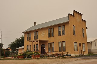
Buffalo Gap is a town in Custer County, South Dakota, United States. The population was 131 at the 2020 census.

<span class="mw-page-title-main">Custer, South Dakota</span> City in South Dakota, United States

Custer is a city in Custer County, South Dakota, United States. The population was 1,919 at the 2020 census. It is the county seat of Custer County.

<span class="mw-page-title-main">Fairburn, South Dakota</span> Town in South Dakota, United States

Fairburn is a town in Custer County, South Dakota, United States. The population was 60 at the 2020 census.

<span class="mw-page-title-main">Hermosa, South Dakota</span> Town in South Dakota, United States

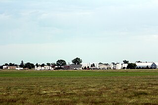
Hermosa is a town near the northern edge of Custer County, South Dakota, United States. The population was 382 at the 2020 census.

<span class="mw-page-title-main">Ethan, South Dakota</span> Town in South Dakota, United States

Ethan is a town in Davison County, South Dakota, United States. It is part of the Mitchell, South Dakota Micropolitan Statistical Area. The population was 365 at the 2020 census. Ethan is located 10 miles south of Mitchell.

<span class="mw-page-title-main">Toronto, South Dakota</span> Town in South Dakota, United States

Toronto is a town in Deuel County, South Dakota, United States. The population was 196 at the 2020 census.

<span class="mw-page-title-main">Stockholm, South Dakota</span> Town in South Dakota, United States

Stockholm is a town in Grant County, South Dakota, United States. The population was 102 at the 2020 census.

<span class="mw-page-title-main">Kadoka, South Dakota</span> City in South Dakota, United States

Kadoka is a city in, and the county seat of, Jackson County, South Dakota, United States. The population was 543 at the 2020 census. The town occupies about 2.3 square miles.

<span class="mw-page-title-main">Hudson, South Dakota</span> Town in South Dakota, United States

Hudson is a town in Lincoln County, South Dakota, United States. The population was 311 at the 2020 census. It is the easternmost community in South Dakota.

<span class="mw-page-title-main">Reliance, South Dakota</span> Town in South Dakota, United States

Reliance is a town in Lyman County, South Dakota, United States. The population was 128 at the 2020 census.

<span class="mw-page-title-main">Crooks, South Dakota</span> City in South Dakota, United States

Crooks is a city in Minnehaha County, South Dakota, United States and is a suburb of Sioux Falls. The population was 1,362 at the 2020 census. Crooks was named New Hope until 1904. The town's present name honors W. A. Crooks, a local politician.

<span class="mw-page-title-main">Utica, South Dakota</span> Town in South Dakota, United States

Utica is a town in Yankton County, South Dakota, United States. The population was 70 at the 2020 census.

References

  1. "ArcGIS REST Services Directory". United States Census Bureau. Retrieved October 15, 2022.
  2. 1 2 U.S. Geological Survey Geographic Names Information System: Pringle, South Dakota
  3. 1 2 "Census Population API". United States Census Bureau. Retrieved October 15, 2022.
  4. 1 2 "U.S. Census website". United States Census Bureau . Retrieved January 31, 2008.
  5. "U.S. Census Bureau: Pringle town, South Dakota". www.census.gov. United States Census Bureau. Retrieved March 23, 2022.
  6. Federal Writers' Project (1940). South Dakota place-names, v.1-3. American guide series. University of South Dakota. p. 57.
  7. "Pringle, South Dakota – Trail Town of the Southern Hills – Legends of America".
  8. Raid On Texas Compound Has Authorities Concerned
  9. "US Gazetteer files 2010". United States Census Bureau. Archived from the original on January 25, 2012. Retrieved June 21, 2012.
  10. "Census of Population and Housing". Census.gov. Retrieved June 4, 2015.
  11. "U.S. Census website". United States Census Bureau . Retrieved June 21, 2012.