Sinclair, Wyoming

Last updated

Sinclair, Wyoming
Sinclair refinery, Wyoming.jpg
Sinclair Oil Refinery (2008)
Carbon County Wyoming Incorporated and Unincorporated areas Sinclair Highlighted 5671150.svg
Location of Sinclair in Carbon County, Wyoming.
Usa edcp location map.svg
Red pog.svg
Sinclair, Wyoming
Location in the United States
Coordinates: 41°46′51″N107°7′1″W / 41.78083°N 107.11694°W / 41.78083; -107.11694
Country United States
State Wyoming
County Carbon
Area
[1]
  Total2.43 sq mi (6.30 km2)
  Land2.43 sq mi (6.30 km2)
  Water0.00 sq mi (0.00 km2)
Elevation
6,588 ft (2,008 m)
Population
 (2010) [2]
  Total433
  Estimate 
(2019) [3]
395
  Density162.48/sq mi (62.73/km2)
Time zone UTC-7 (Mountain (MST))
  Summer (DST) UTC-6 (MDT)
ZIP code
82334
Area code 307
FIPS code 56-71150 [4]
GNIS feature ID1609153 [5]
Sinclair Refinery in 2011 Sinclair Refinery, Sinclair, Wyoming.jpg
Sinclair Refinery in 2011

Sinclair is a town in Carbon County, Wyoming, United States.

Contents

History

The town was originally called Parco, after the Producers & Refiners Corporation (or PARCO) which founded the refinery and the company town. [6] It was renamed Sinclair after PARCO was acquired during the Great Depression by Sinclair Consolidated Oil Corporation. The original refinery, located just east of town, remains in use to this day. Sinclair's population was 433 at the 2010 census.

The town was built as a planned community in 1924–1925, designed by Denver architects Fisher & Fisher in a Spanish Colonial Revival style. The historic center of town was designated the Parco Historic District in 1987. [7] [8]

Just six miles east of Sinclair is the ghost town site of Benton, Wyoming at milepost 672.1 of the Union Pacific Railroad. [9] As the terminal of the railroad at the time, Benton had a colorful three-month history which ended in September 1868 with a visit from Republican presidential candidate Ulysses S. Grant and the departure of the final overland wagon trains on the Mormon Trail headed for the Salt Lake Valley before completion of the railroad the following year.

Three miles east of the Benton site is Fort Fred Steele State Historic Site. [10] The original Ft. Steele was named for American Civil War Union General Frederick Steele and established June 20, 1868, to protect the Union Pacific Railway as it rapidly expanded west. The fort was deactivated August 7, 1886, and most of the buildings at the fort were sold and moved to the settlement which had grown up around the fort and other locations. The small community continued until 1939 when the Lincoln Highway was paved and rerouted to coincide with what later became Interstate 80. In 1940, following the short-lived Supreme Court decision Minersville School District v. Gobitis , residents tarred and feathered the town's Jehovah's Witnesses. The Wyoming State Legislature preserved what remained in 1973 with creation of the state historical site.

Geography

Sinclair is located at 41°46′51″N107°7′1″W / 41.78083°N 107.11694°W / 41.78083; -107.11694 (41.780782, –107.116826). [11]

According to the United States Census Bureau, the town has a total area of 2.43 square miles (6.29 km2), all land. [12]

Demographics

Historical population
CensusPop.Note
1930 727
1940 604−16.9%
1950 77528.3%
1960 621−19.9%
1970 445−28.3%
1980 58631.7%
1990 500−14.7%
2000 423−15.4%
2010 4332.4%
2019 (est.)395 [3] −8.8%
U.S. Decennial Census [13]

2010 census

As of the census [2] of 2010, there were 433 people, 170 households, and 123 families living in the town. The population density was 178.2 inhabitants per square mile (68.8/km2). There were 198 housing units at an average density of 81.5 per square mile (31.5/km2). The racial makeup of the town was 94.2% White, 0.7% Native American, 0.5% Asian, 2.1% from other races, and 2.5% from two or more races. Hispanic or Latino of any race were 6.5% of the population.

There were 170 households, of which 32.4% had children under the age of 18 living with them, 64.7% were married couples living together, 3.5% had a female householder with no husband present, 4.1% had a male householder with no wife present, and 27.6% were non-families. 23.5% of all households were made up of individuals, and 7% had someone living alone who was 65 years of age or older. The average household size was 2.52 and the average family size was 2.95.

The median age in the town was 39.5 years. 24.9% of residents were under the age of 18; 7% were between the ages of 18 and 24; 25.6% were from 25 to 44; 29.9% were from 45 to 64; and 12.5% were 65 years of age or older. The gender makeup of the town was 52.2% male and 47.8% female.

2000 census

As of the census [4] of 2000, there were 423 people, 168 households, and 115 families living in the town. The population density was 174.0 people per square mile (67.2/km2). There were 211 housing units at an average density of 86.8 per square mile (33.5/km2). The racial makeup of the town was 96.22% White, 0.47% African American, 1.42% Native American, 0.95% from other races, and 0.95% from two or more races. Hispanic or Latino of any race were 2.60% of the population.

There were 168 households, out of which 34.5% had children under the age of 18 living with them, 56.0% were married couples living together, 7.7% had a female householder with no husband present, and 31.0% were non-families. 27.4% of all households were made up of individuals, and 13.7% had someone living alone who was 65 years of age or older. The average household size was 2.52 and the average family size was 3.02.

In the town, the population was spread out, with 27.2% under the age of 18, 6.1% from 18 to 24, 26.0% from 25 to 44, 27.9% from 45 to 64, and 12.8% who were 65 years of age or older. The median age was 41 years. For every 100 females, there were 97.7 males. For every 100 females age 18 and over, there were 102.6 males.

The median income for a household in the town was $48,214, and the median income for a family was $54,688. Males had a median income of $36,875 versus $26,250 for females. The per capita income for the town was $22,384. About 1.7% of families and 4.7% of the population were below the poverty line, including 6.1% of those under age 18 and none of those age 65 or over.

Education

Public education in the town of Sinclair is provided by Carbon County School District #1. Zoned campuses include Rawlins Elementary School (grades K–5), Rawlins Middle School (grades 6–8), and Rawlins High School (grades 9–12).

Sinclair has a public library, a branch of the Carbon County Library System. [14]

See also

Related Research Articles

<span class="mw-page-title-main">Platte County, Wyoming</span> County in Wyoming, United States

Platte County is a county located in the U.S. state of Wyoming. As of the 2020 United States Census, the population was 8,605. Its county seat is Wheatland.

<span class="mw-page-title-main">Niobrara County, Wyoming</span> County in the United States

Niobrara County is a county in the U.S. state of Wyoming. As of the 2020 United States Census, the population was 2,467, making it the least populous county in Wyoming. Its county seat is Lusk. Its eastern boundary abuts the west lines of the states of Nebraska and South Dakota.

<span class="mw-page-title-main">Crook County, Wyoming</span> County in Wyoming, United States

Crook County is a county in the northeastern corner of the U.S. state of Wyoming. As of the 2020 United States Census, the population was 7,181, making it the third-least populous county in Wyoming. Its county seat and largest city is Sundance. The county is located at the northwestern extreme of the Black Hills, which are its defining geographical feature.

<span class="mw-page-title-main">Carbon County, Wyoming</span> County in Wyoming, United States

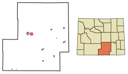
Carbon County is a county in the U.S. state of Wyoming. As of the 2020 United States Census, the population was 14,537. Its county seat is Rawlins. Its south border abuts the north line of Colorado.

<span class="mw-page-title-main">Campbell County, Wyoming</span> County in Wyoming, United States

Campbell County is a county in the U.S. state of Wyoming. As of the 2020 United States Census, the population was 47,026, making it the third-most populous county in Wyoming. Its county seat is Gillette.

<span class="mw-page-title-main">Albert City, Iowa</span> City in Iowa, United States

Albert City is a city in Buena Vista County, Iowa, United States. The population was 677 at the 2020 census.

<span class="mw-page-title-main">Atwood, Kansas</span> City in Rawlins County, Kansas

Atwood is a city in and the county seat of Rawlins County, Kansas, United States. As of the 2020 census, the population of the city was 1,290.

<span class="mw-page-title-main">Nicholson Township, Wyoming County, Pennsylvania</span> Township in Pennsylvania, United States

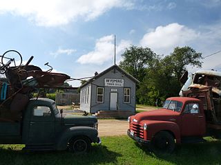
Nicholson Township is a township in Wyoming County, Pennsylvania, United States. The population was 1,259 at the 2020 census.

<span class="mw-page-title-main">Wyoming, Iowa County, Wisconsin</span> Town in Wisconsin, United States

The Town of Wyoming is a town located in Iowa County, Wisconsin, United States. The population was 317 at the 2020 census.

<span class="mw-page-title-main">Rock River, Wyoming</span> Town in Wyoming, United States

Rock River is a town in Albany County, Wyoming, United States. As of the 2010 census, the town population was 245.

<span class="mw-page-title-main">Dixon, Wyoming</span> Town in Wyoming, United States

Dixon is a town in Carbon County, Wyoming, United States. The population was 97 at the 2010 census.

<span class="mw-page-title-main">Rawlins, Wyoming</span> City in the United States

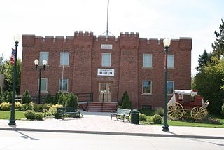
Rawlins is a city in Carbon County, Wyoming, United States. The population was 8,221 at the 2020 census. It is the county seat of Carbon County. It was named for Union General John Aaron Rawlins, who camped in the locality in 1867.

<span class="mw-page-title-main">Moorcroft, Wyoming</span> Town in Wyoming, United States

Moorcroft is a town in Crook County, Wyoming, United States. The population was 946 at the 2020 census.

<span class="mw-page-title-main">Jeffrey City, Wyoming</span> Census-designated place in Wyoming, United States

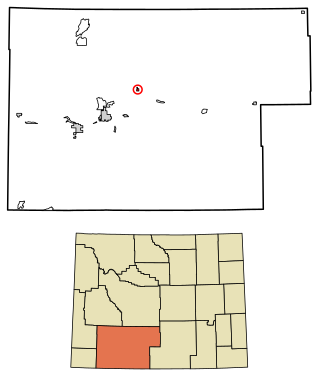
Jeffrey City is a former uranium mining boomtown located in Fremont County, in the central part of the U.S. state of Wyoming. The town is known in Wyoming and the American West as symbol of a boomtown that went "bust" very quickly, as the mine was shut down in 1982 and over 95% of the inhabitants left the town within three years. The population was 58 at the 2010 census, far lower than its onetime population of several thousand people. For statistical purposes, the United States Census Bureau has defined Jeffrey City as a census-designated place (CDP).

<span class="mw-page-title-main">Dayton, Wyoming</span> Town in Wyoming, United States

Dayton is a town in Sheridan County, Wyoming, United States. The population was 822 at the 2020 census.

<span class="mw-page-title-main">Bairoil, Wyoming</span> Town in Wyoming, United States

Bairoil is a town in Sweetwater County, Wyoming, United States. The population was 106 at the 2010 census.

<span class="mw-page-title-main">Superior, Wyoming</span> Town in Wyoming, United States

Superior is a town in Sweetwater County, Wyoming, United States. The population was 336 at the 2010 census.

<span class="mw-page-title-main">Wamsutter, Wyoming</span> Town in Wyoming, United States

Wamsutter is a town in Sweetwater County, Wyoming, United States. The population was 203 at the 2020 census.

<span class="mw-page-title-main">Lyman, Wyoming</span> Town in Wyoming, United States

Lyman is a town in Uinta County, Wyoming, United States. The population was 2,115 at the 2010 census.

<span class="mw-page-title-main">Warsaw (village), New York</span> Village in New York, United States

Warsaw is a village and the county seat of Wyoming County, New York, United States. It lies inside the Town of Warsaw. The village of Warsaw is near the center of the town in a valley. The population was 3,473 at the 2010 census. A branch of Genesee Community College is in Warsaw.

References

  1. "2019 U.S. Gazetteer Files". United States Census Bureau. Retrieved August 7, 2020.
  2. 1 2 "U.S. Census website". United States Census Bureau . Retrieved December 14, 2012.
  3. 1 2 "Population and Housing Unit Estimates". United States Census Bureau. May 24, 2020. Retrieved May 27, 2020.
  4. 1 2 "U.S. Census website". United States Census Bureau . Retrieved January 31, 2008.
  5. "US Board on Geographic Names". United States Geological Survey. October 25, 2007. Retrieved January 31, 2008.
  6. "Parco (Sinclair) Historic District". Archived from the original on January 16, 2003. Retrieved June 27, 2023.
  7. Kendrick, Gregory D.; Rosenberg, Robert; Bricher-Wade, Sheila. (January 15, 1987). "National Register of Historic Places Inventory - Nomination Form: Parco Historic District". National Park Service. with accompanying 13 photos
  8. "National Register Information System". National Register of Historic Places . National Park Service. July 9, 2010.
  9. "Wyoming Ghost Towns" Retrieved February 16, 2012.
  10. "Ft. Fred Steele" Retrieved February 16, 2012.
  11. "US Gazetteer files: 2010, 2000, and 1990". United States Census Bureau. February 12, 2011. Retrieved April 23, 2011.
  12. "US Gazetteer files 2010". United States Census Bureau. Archived from the original on January 25, 2012. Retrieved December 14, 2012.
  13. "Census of Population and Housing". Census.gov. Retrieved June 4, 2015.
  14. "Wyoming Public Libraries". PublicLibraries.com. Retrieved June 13, 2019.