Granger is a town along Blacks Fork near the western edge of Sweetwater County, Wyoming, United States. The population was 139 at the 2010 census. It is located near the confluence of the Blacks Fork and the Hams Fork rivers. The geography of the area is flat with semi-arid scrub.
Tulle is a commune in central France. It is the third-largest town in the former region of Limousin and is the capital of the department of Corrèze, in the region of Nouvelle-Aquitaine. Tulle is also the episcopal see of the Roman Catholic Diocese of Tulle.

Powder River is a tributary of the Yellowstone River, approximately 375 miles (604 km) long in northeastern Wyoming and southeastern Montana in the United States. Combined with its tributary, the South Fork Powder River, it is 550 miles long. It drains an area historically known as the Powder River Country on the high plains east of the Bighorn Mountains.

The Madison River is a headwater tributary of the Missouri River, approximately 183 miles (295 km) long, in Wyoming and Montana. Its confluence with the Jefferson and Gallatin rivers near Three Forks, Montana forms the Missouri River.

The Gallatin River is a tributary of the Missouri River, approximately 120 mi (193 km) long, in the U.S. states of Wyoming and Montana. It is one of three rivers, along with the Jefferson and Madison, that converge near Three Forks, Montana, to form the Missouri.
Three Forks is an unincorporated community in Pennington County, South Dakota, United States. It lies at the intersection of U.S. Routes 16 and 385, just north of Hill City along Spring Creek. A small general store featuring fuel is open year-round; other businesses are open seasonally, including a campground, a motel, a miniature golf-course, and an ice-cream stand. The campground is the site of an annual Octoberfest event, and the area is heavily patronized during the Sturgis Motorcycle Rally in August of each year. In recent years, considerable residential development of the immediate area has swollen its population.

Buffalo Bill Cody Scenic Byway is in the U.S. state of Wyoming and spans most of the distance from Cody, Wyoming to Yellowstone National Park. The 27.5-mile (44.3 km) scenic highway follows the north fork of the Shoshone River through the Wapiti Valley to Sylvan Pass and the eastern entrance to Yellowstone. Most of the scenic byway is contained within Shoshone National Forest and is also known as US Highway 14 (US 14), US 16 and US 20.

Loyalsock Creek is a 64-mile-long (103 km) tributary of the West Branch Susquehanna River located chiefly in Sullivan and Lycoming counties in Pennsylvania in the United States. As the crow flies, Lycoming County is about 130 miles (209 km) northwest of Philadelphia and 165 miles (266 km) east-northeast of Pittsburgh.

Mehoopany Creek is a tributary of the Susquehanna River in Sullivan and Wyoming counties, Pennsylvania, in the United States. It is approximately 26.8 miles (43.1 km) long. In Sullivan County the creek flows through Colley Township and in Wyoming County it flows through Forkston Township and Mehoopany Township. The stream's watershed has an area of 123 square miles (320 km2). Its major tributaries include Stony Brook and North Fork Mehoopany Creek.

Blacks Fork is a 175-mile-long (282 km) tributary of the Green River in Utah and Wyoming in the United States.
Freedom is an unincorporated community in both northeastern Caribou County, Idaho, and northwestern Lincoln County, Wyoming, in the United States; the Wyoming portion of the community is also a census-designated place (CDP). The population was 247 at the 2020 census.

The Colorado River Storage Project is a United States Bureau of Reclamation project designed to oversee the development of the upper basin of the Colorado River. The project provides hydroelectric power, flood control and water storage for participating states along the upper portion of the Colorado River and its major tributaries.
The Overland Trail was a stagecoach and wagon trail in the American West during the 19th century. While portions of the route had been used by explorers and trappers since the 1820s, the Overland Trail was most heavily used in the 1860s as a route alternative to the Oregon, California, and Mormon trails through central Wyoming. The Overland Trail was famously used by the Overland Stage Company owned by Ben Holladay to run mail and passengers to Salt Lake City, Utah, via stagecoaches in the early 1860s. Starting from Atchison, Kansas, the trail descended into Colorado before looping back up to southern Wyoming and rejoining the Oregon Trail at Fort Bridger. The stage line operated until 1869 when the completion of the First transcontinental railroad eliminated the need for mail service via stagecoach.

Fort McKinney (1877–1894) was a military post located in North Eastern Wyoming, near the Powder River.

Cantonment Reno also known as Fort McKinney 1 was a US Army post or cantonment located on the Powder River near the old Bozeman Trail crossing. A previous fort near the site had been abandoned and burned after the Fort Laramie Treaty of 1868. Cantonment Reno was re-established in late 1876, just upstream of the site of old Fort Reno. Cantonment Reno started as a temporary base of operations for General George Crooks' 1876 Big Horn Expedition,. Crook's Expedition was part of the intensive campaign against the Sioux and Cheyenne in late 1876, following Custer's defeat at the Battle of the Little Bighorn.

The Powder River Crossing, officially known as Powder River Station-Powder River Crossing , is an abandoned settlement located on the east bank of the Powder River in southeast Johnson County about twenty-four miles east of Kaycee, Wyoming. It developed after a wooden toll bridge was built across the Powder River in 1877, at a site that was originally used as a ford. With crossing secured, a settlement developed here in the late 19th century, incorporating a stage stop on the Bozeman Trail. The site is notable for having well-preserved wagon ruts from the pioneer era.

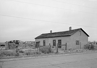
Granger Station State Historic Site, also known as Granger Stage Station, South Bend Station and Ham's Fork Station, is a state park in Granger, Wyoming, United States, that is listed on the National Register of Historic Places (NRHP).

Pilot Peak, elevation 11,699 feet (3,566 m), is a prominent mountain peak in the Absaroka Range in Park County, Wyoming. The peak is visible from US Route 212, the Beartooth Highway just east of the Northeast Entrance Station to Yellowstone National Park. Index Peak rises just north of Pilot Peak.

The Middle Fork Popo Agie River is a river in Wyoming in the United States. The river is 54 miles (87 km) long. The river is sometimes referred to as simply the 'Middle Fork'. The river is part of the Popo Agie Watershed and from its headwaters in the Wind River Range until it joins with the North Fork of the Popo Agie River, the river and its tributaries irrigate roughly 11,503 acres.
Millburne is an unincorporated community along the Blacks Fork river in central Uinta County, Wyoming, United States.


