Dixon, Wyoming

Last updated

Dixon, Wyoming
Stockgrowers Bank.JPG
The Dixon Town Hall, located at B Street and North 3rd Street.
Carbon County Wyoming Incorporated and Unincorporated areas Dixon Highlighted 5620690.svg
Location of Dixon in Carbon County, Wyoming.
Usa edcp location map.svg
Red pog.svg
Dixon, Wyoming
Location in the United States
Coordinates: 41°2′6″N107°32′10″W / 41.03500°N 107.53611°W / 41.03500; -107.53611
Country United States
State Wyoming
County Carbon
Area
[1]
  Total0.13 sq mi (0.34 km2)
  Land0.13 sq mi (0.34 km2)
  Water0.00 sq mi (0.00 km2)
Elevation
6,355 ft (1,937 m)
Population
 (2010) [2]
  Total97
  Estimate 
(2019) [3]
94
  Density717.56/sq mi (276.38/km2)
Time zone UTC-7 (Mountain (MST))
  Summer (DST) UTC-6 (MDT)
ZIP code
82323
Area code 307
FIPS code 56-20690 [4]
GNIS feature ID1587668 [5]

Dixon is a town in Carbon County, Wyoming, United States. The population was 97 at the 2010 census.

Contents

Geography

Dixon is located at 41°2′6″N107°32′10″W / 41.03500°N 107.53611°W / 41.03500; -107.53611 (41.034934, -107.536111). [6]

According to the United States Census Bureau, the town has a total area of 0.13 square miles (0.34 km2), all land. [7]

Demographics

Historical population
CensusPop.Note
1920 170
1930 145−14.7%
1940 94−35.2%
1950 12431.9%
1960 108−12.9%
1970 72−33.3%
1980 8213.9%
1990 70−14.6%
2000 7912.9%
2010 9722.8%
2019 (est.)94 [3] −3.1%
U.S. Decennial Census [8]

2010 census

As of the census [2] of 2010, there were 97 people, 43 households, and 27 families living in the town. The population density was 746.2 inhabitants per square mile (288.1/km2). There were 64 housing units at an average density of 492.3 per square mile (190.1/km2). The racial makeup of the town was 88.7% White, 3.1% African American, 1.0% Native American, 4.1% from other races, and 3.1% from two or more races. Hispanic or Latino of any race were 12.4% of the population.

There were 43 households, of which 30.2% had children under the age of 18 living with them, 46.5% were married couples living together, 2.3% had a female householder with no husband present, 14.0% had a male householder with no wife present, and 37.2% were non-families. 30.2% of all households were made up of individuals, and 4.7% had someone living alone who was 65 years of age or older. The average household size was 2.26 and the average family size was 2.70.

The median age in the town was 33.5 years. 21.6% of residents were under the age of 18; 9.4% were between the ages of 18 and 24; 30.9% were from 25 to 44; 25.8% were from 45 to 64; and 12.4% were 65 years of age or older. The gender makeup of the town was 56.7% male and 43.3% female.

2000 census

As of the census [4] of 2000, there were 79 people, 41 households, and 23 families living in the town. The population density was 584.1 people per square mile (217.9/km2). There were 67 housing units at an average density of 495.4 per square mile (184.8/km2). The racial makeup of the town was 96.20% White and 3.80% Native American. Hispanic or Latino of any race were 1.27% of the population.

There were 41 households, out of which 19.5% had children under the age of 18 living with them, 51.2% were married couples living together, 2.4% had a female householder with no husband present, and 43.9% were non-families. 39.0% of all households were made up of individuals, and 14.6% had someone living alone who was 65 years of age or older. The average household size was 1.93 and the average family size was 2.57.

In the town, the population was spread out, with 15.2% under the age of 18, 6.3% from 18 to 24, 29.1% from 25 to 44, 30.4% from 45 to 64, and 19.0% who were 65 years of age or older. The median age was 45 years. For every 100 females, there were 102.6 males. For every 100 females age 18 and over, there were 139.3 males.

The median income for a household in the town was $23,750, and the median income for a family was $37,500. Males had a median income of $35,417 versus $16,250 for females. The per capita income for the town was $15,950. There were no families and 8.0% of the population living below the poverty line, including no under eighteens and none of those over 64.

Education

Public education in the town of Dixon is provided by Carbon County School District #1. Little Snake River Valley School, a K-12 campus, serves the town.

See also

Related Research Articles

<span class="mw-page-title-main">Jenkinsburg, Georgia</span> City in Georgia, United States

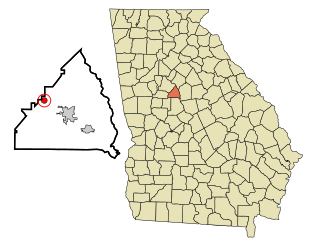
Jenkinsburg is a city in Butts County, Georgia, United States. The population was 370 at the 2010 census.

<span class="mw-page-title-main">Dixon, Iowa</span> City in Iowa, United States

Dixon is a city in Scott County, Iowa, United States. The population was 202 at the time of the 2020 census.

<span class="mw-page-title-main">Caswell, Maine</span> Town in the state of Maine, United States

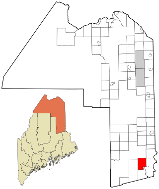
Caswell is a town in Aroostook County, Maine, United States. The population was 293 at the 2020 census.

<span class="mw-page-title-main">Haynesville, Maine</span> Town in the state of Maine, United States

Haynesville is a town in Aroostook County, Maine, United States. The population was 97 at the 2020 census.

<span class="mw-page-title-main">Newcastle, Maine</span> Town in the state of Maine, United States

Newcastle is a town in Lincoln County, Maine, United States. The population was 1,848 at the 2020 census. The village of Newcastle is located in the eastern part of the town, on the Damariscotta River. Together with the village of Damariscotta linked by the Main Street bridge, they form the Twin Villages.

Greenwood is a town in Oxford County, Maine, United States. The population was 774 at the 2020 census. The town was named for surveyor Alexander Greenwood. The village of Locke Mills, on State Route 26 in the northern part of Greenwood, is the town's urban center and largest settlement.

Stacyville is a town in Penobscot County, Maine, United States, in the foothills of Mount Katahdin. The population was 380 at the 2020 census.

<span class="mw-page-title-main">Winger, Minnesota</span> City in Minnesota, United States

Winger is a city in Polk County, Minnesota, United States. It is part of the Grand Forks, ND-MN Metropolitan Statistical Area. The population was 174 at the 2020 census.

<span class="mw-page-title-main">Dixon, Nebraska</span> Village in Dixon County, Nebraska, United States

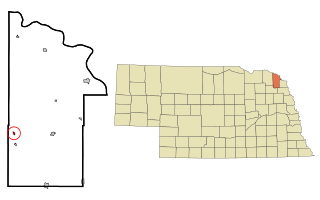
Dixon is a rural village in Dixon County, Nebraska, United States. The population was 87 at the 2010 census. There is a granary at Dixon, a post office, a community center, a small cafe, and a fire and rescue department.

<span class="mw-page-title-main">Knox, Pennsylvania</span> Borough in Pennsylvania, United States

Knox is a borough in Clarion County, Pennsylvania, United States. The population was 1,102 at the 2020 census.

<span class="mw-page-title-main">Plymptonville, Pennsylvania</span> Census-designated place in Pennsylvania, United States

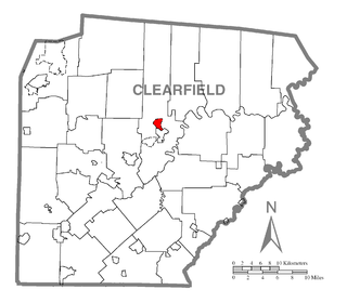
Plymptonville is a census-designated place (CDP) in Clearfield County, Pennsylvania, United States. The population was 972 at the 2020 census.

<span class="mw-page-title-main">Davis, South Dakota</span> Town in South Dakota, United States

Davis is a town in Turner County, South Dakota, United States. The population was 54 at the 2020 census.

<span class="mw-page-title-main">Highland, Douglas County, Wisconsin</span> Town in Wisconsin, United States

Highland is a town in Douglas County, Wisconsin, United States. The population was 245 at the 2000 census.

<span class="mw-page-title-main">Moscow, Wisconsin</span> Town in Wisconsin, United States

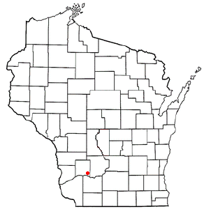
Moscow is a town in Iowa County, Wisconsin, United States. The population was 582 at the 2020 census. The unincorporated community of Moscow is located in the town. The ghost town of Adamsville was also located in the town.

<span class="mw-page-title-main">Buena Vista, Richland County, Wisconsin</span> Town in Wisconsin, United States

Buena Vista is a town in Richland County, Wisconsin, United States. The population was 1,807 at the 2020 census. The unincorporated communities of Gotham, and Sextonville are located within the town.

<span class="mw-page-title-main">Baggs, Wyoming</span> Town in Wyoming, United States

Baggs is a town in Carbon County, Wyoming, United States. The population was 411 at the 2020 census. Baggs is home to the Outlaw Stop, a branch of the Little Snake River Museum, which is headquartered in Savery.

<span class="mw-page-title-main">Midwest, Wyoming</span> Town in Wyoming, United States

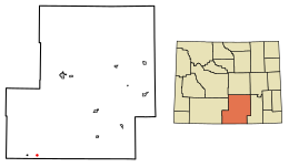
Midwest is a town in Natrona County, Wyoming, United States. It is part of the Casper, Wyoming Metropolitan Statistical Area. The population was 404 at the 2010 census.

<span class="mw-page-title-main">Bairoil, Wyoming</span> Town in Wyoming, United States

Bairoil is a town in Sweetwater County, Wyoming, United States. The population was 106 at the 2010 census.

<span class="mw-page-title-main">Mountain View, Wyoming</span> Town in Wyoming, United States

Mountain View is a town in Uinta County, Wyoming, United States. The population was 1,286 at the 2010 census.

<span class="mw-page-title-main">Ten Sleep, Wyoming</span> Town in Wyoming, United States

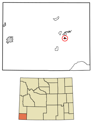
Ten Sleep is a town in Washakie County, Wyoming, United States. It is located in the Bighorn Basin in the western foothills of the Bighorn Mountains, approximately 26 miles (42 km) east of Worland and 59 miles (95 km) west of Buffalo.

References

  1. "2019 U.S. Gazetteer Files". United States Census Bureau. Retrieved August 7, 2020.
  2. 1 2 "U.S. Census website". United States Census Bureau . Retrieved December 14, 2012.
  3. 1 2 "Population and Housing Unit Estimates". United States Census Bureau. May 24, 2020. Retrieved May 27, 2020.
  4. 1 2 "U.S. Census website". United States Census Bureau . Retrieved January 31, 2008.
  5. "US Board on Geographic Names". United States Geological Survey. October 25, 2007. Retrieved January 31, 2008.
  6. "US Gazetteer files: 2010, 2000, and 1990". United States Census Bureau. February 12, 2011. Retrieved April 23, 2011.
  7. "US Gazetteer files 2010". United States Census Bureau. Archived from the original on July 2, 2012. Retrieved December 14, 2012.
  8. "Census of Population and Housing". Census.gov. Retrieved June 4, 2015.

Commons-logo.svg Media related to Dixon, Wyoming at Wikimedia Commons