Riverside, Wyoming

Last updated

Riverside, Wyoming
Carbon County Wyoming Incorporated and Unincorporated areas Riverside Highlighted 5666075.svg
Location of Riverside in Carbon County, Wyoming.
Usa edcp location map.svg
Red pog.svg
Riverside, Wyoming
Location in the United States
Coordinates: 41°12′55″N106°46′59″W / 41.21528°N 106.78306°W / 41.21528; -106.78306
Country United States
State Wyoming
County Carbon
Area
[1]
  Total0.27 sq mi (0.70 km2)
  Land0.27 sq mi (0.70 km2)
  Water0.00 sq mi (0.00 km2)
Elevation
7,142 ft (2,177 m)
Population
 (2010) [2]
  Total52
  Estimate 
(2019) [3]
52
  Density192.59/sq mi (74.47/km2)
Time zone UTC-7 (Mountain (MST))
  Summer (DST) UTC-6 (MDT)
ZIP code
82325
Area code 307
FIPS code 56-66075 [4]
GNIS feature ID1593486 [5]

Riverside is a town in Carbon County, Wyoming, United States. The population was 52 at the 2010 census.

Contents

Geography

Riverside is located at 41°12′55″N106°46′59″W / 41.21528°N 106.78306°W / 41.21528; -106.78306 (41.215243, –106.782961). [6]

According to the United States Census Bureau, the town has a total area of 0.27 square miles (0.70 km2), all land. [7]

According to the U.S. National Climatic Data Center, Riverside is, together with the town of West Yellowstone in Yellowstone National Park, the coldest (inhabited) spot in the whole state of Wyoming. [8] On February 9, 1933, −66 °F or −54.4 °C was recorded there, the coldest temperature ever recorded in Wyoming. [9]

Demographics

Historical population
CensusPop.Note
1910 49
1920 29−40.8%
1930 3417.2%
1940 68100.0%
1950 50−26.5%
1960 8774.0%
1970 46−47.1%
1980 5519.6%
1990 8554.5%
2000 59−30.6%
2010 52−11.9%
2019 (est.)52 [3] 0.0%
U.S. Decennial Census [10]

2010 census

As of the census [2] of 2010, there were 52 people, 34 households, and 15 families residing in the town. The population density was 192.6 inhabitants per square mile (74.4/km2). There were 53 housing units at an average density of 196.3 per square mile (75.8/km2). The racial makeup of the town was 98.1% White and 1.9% Native American. Hispanic or Latino of any race were 1.9% of the population.

There were 34 households, of which 5.9% had children under the age of 18 living with them, 41.2% were married couples living together, 2.9% had a male householder with no wife present, and 55.9% were non-families. 55.9% of all households were made up of individuals, and 20.6% had someone living alone who was 65 years of age or older. The average household size was 1.53 and the average family size was 2.20.

The median age in the town was 58 years. 3.8% of residents were under the age of 18; 3.8% were between the ages of 18 and 24; 15.4% were from 25 to 44; 48.1% were from 45 to 64; and 28.8% were 65 years of age or older. The gender makeup of the town was 59.6% male and 40.4% female.

2000 census

As of the census [4] of 2000, there were 59 people, 28 households, and 21 families residing in the town. The population density was 225.6 people per square mile (87.6/km2). There were 45 housing units at an average density of 172.1 per square mile (66.8/km2). The racial makeup of the town was 100.00% White.

There were 28 households, out of which 10.7% had children under the age of 18 living with them, 71.4% were married couples living together, and 25.0% were non-families. 21.4% of all households were made up of individuals, and 7.1% had someone living alone who was 65 years of age or older. The average household size was 2.11 and the average family size was 2.33.

In the town, the population was spread out, with 11.9% under the age of 18, 3.4% from 18 to 24, 18.6% from 25 to 44, 44.1% from 45 to 64, and 22.0% who were 65 years of age or older. The median age was 50 years. For every 100 females, there were 110.7 males. For every 100 females age 18 and over, there were 126.1 males.

The median income for a household in the town was $48,125, and the median income for a family was $55,000. Males had a median income of $23,750 versus $25,417 for females. The per capita income for the town was $40,276. None of the population or families were below the poverty line.

Education

Public education in the town of Riverside is provided by Carbon County School District #2. Encampment School , a K–12 campus in neighboring Encampment, serves the town.

Related Research Articles

<span class="mw-page-title-main">Johnson County, Wyoming</span> County in Wyoming, United States

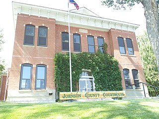
Johnson County is a county in the north central part of the U.S. state of Wyoming. At the 2020 United States Census, the population was 8,447. The county seat is Buffalo. Kaycee is the only other incorporated town in the county.

<span class="mw-page-title-main">Carbon County, Wyoming</span> County in Wyoming, United States

Carbon County is a county in the U.S. state of Wyoming. As of the 2020 United States Census, the population was 14,537. Its county seat is Rawlins. Its south border abuts the north line of Colorado.

<span class="mw-page-title-main">Pumphrey, Maryland</span> Unincorporated community in Maryland, United States

Pumphrey is an unincorporated community and former census-designated place (CDP) in Anne Arundel County, Maryland, United States. At the 2000 census, the population was 5,317. It was split between the Linthicum and Brooklyn Park CDPs for the 2010 census.

<span class="mw-page-title-main">Curtin Township, Centre County, Pennsylvania</span> Township in Pennsylvania, United States

Curtin Township is a township in Centre County, Pennsylvania, United States. It is part of the State College, Pennsylvania Metropolitan Statistical Area. The population was 500 at the 2020 census.

<span class="mw-page-title-main">Horton Township, Elk County, Pennsylvania</span> Township in Pennsylvania, United States

Horton Township is a township in Elk County, Pennsylvania, United States. The population was 1,365 at the 2020 census, down from 1,452 in 2010.

<span class="mw-page-title-main">Nicholson, Pennsylvania</span> Borough in Pennsylvania, United States

Nicholson is a borough in Wyoming County, Pennsylvania. The population was 698 at the 2020 census.

<span class="mw-page-title-main">Codorus Township, Pennsylvania</span> Township in Pennsylvania, United States

Codorus Township is a township in York County, Pennsylvania, United States. The population was 3,898 at the 2020 census.

<span class="mw-page-title-main">Rock River, Wyoming</span> Town in Wyoming, United States

Rock River is a town in Albany County, Wyoming, United States. As of the 2010 census, the town population was 245.

<span class="mw-page-title-main">Woods Landing-Jelm, Wyoming</span> CDP in Wyoming, United States

Woods Landing-Jelm is a census-designated place (CDP) in Albany County, Wyoming, United States. The population was 97 at the 2010 census.

<span class="mw-page-title-main">Elk Mountain, Wyoming</span> Town in Wyoming, United States

Elk Mountain is a town in Carbon County, Wyoming, United States. The population was 150 at the 2020 census. The town shares its name with a mountain 7 miles (11 km) to its southwest.

<span class="mw-page-title-main">Encampment, Wyoming</span> Town in Wyoming, United States

Encampment is a town in southern Carbon County, Wyoming, United States. The population was 450 at the 2010 census.

<span class="mw-page-title-main">Hanna, Wyoming</span> Town in Wyoming, United States

Hanna is a town in Carbon County, Wyoming, United States. The population was 683 at the 2020 census. The town was started as a coal supply location for the Union Pacific Railroad. Much of the old town is built on top of the former workings of the Hanna No. 4 mine. On December 18, 1979, the Town of Hanna annexed the adjacent Town of Elmo. The population peaked at 2,288 in 1980 and has declined as local coal mines have ceased operation.

<span class="mw-page-title-main">Bar Nunn, Wyoming</span> Town in Wyoming, United States

Bar Nunn is a town in Natrona County, Wyoming, United States. It is a part of the Casper, Wyoming Metropolitan Statistical Area. The population was 2,213 at the 2010 census. It was incorporated in 1980.

<span class="mw-page-title-main">Edgerton, Wyoming</span> Town in Wyoming, United States

Edgerton is a town in Natrona County, Wyoming, United States. It is part of the Casper, Wyoming Metropolitan Statistical Area. The population was 195 at the 2010 census.

<span class="mw-page-title-main">Evansville, Wyoming</span> Town in Wyoming, United States

Evansville is a town in Natrona County, Wyoming, United States. It is part of the Casper, Wyoming Metropolitan Statistical Area. The population was 2,544 at the 2010 census.

<span class="mw-page-title-main">Midwest, Wyoming</span> Town in Wyoming, United States

Midwest is a town in Natrona County, Wyoming, United States. It is part of the Casper, Wyoming Metropolitan Statistical Area. The population was 404 at the 2010 census.

Mountain View is a census-designated place in Natrona County, Wyoming, United States. It is part of the Casper, Wyoming Metropolitan Statistical Area. The population was 96 at the 2010 census.

<span class="mw-page-title-main">Bairoil, Wyoming</span> Town in Wyoming, United States

Bairoil is a town in Sweetwater County, Wyoming, United States. The population was 106 at the 2010 census.

<span class="mw-page-title-main">Lyman, Wyoming</span> Town in Wyoming, United States

Lyman is a town in Uinta County, Wyoming, United States. The population was 2,115 at the 2010 census.

Clear Lake is a town in Polk County, Wisconsin, United States. The population was 800 at the 2000 census. The Village of Clear Lake is located within the town.

References

  1. "2019 U.S. Gazetteer Files". United States Census Bureau. Retrieved August 7, 2020.
  2. 1 2 "U.S. Census website". United States Census Bureau . Retrieved December 14, 2012.
  3. 1 2 "Population and Housing Unit Estimates". United States Census Bureau. May 24, 2020. Retrieved May 27, 2020.
  4. 1 2 "U.S. Census website". United States Census Bureau . Retrieved January 31, 2008.
  5. "US Board on Geographic Names". United States Geological Survey. October 25, 2007. Retrieved January 31, 2008.
  6. "US Gazetteer files: 2010, 2000, and 1990". United States Census Bureau. February 12, 2011. Retrieved April 23, 2011.
  7. "US Gazetteer files 2010". United States Census Bureau. Archived from the original on January 25, 2012. Retrieved December 14, 2012.
  8. Team, National Weather Service Corporate Image Web. "National Weather Service Climate". w2.weather.gov. Retrieved April 17, 2020.
  9. Blake, LA (November 14, 2014). "Lowest temperatures ever recorded in every state". ABC7 Los Angeles.
  10. "Census of Population and Housing". Census.gov. Retrieved June 4, 2015.