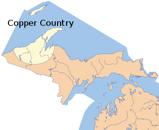
The Copper Country is an area in the Upper Peninsula of Michigan in the United States, including all of Keweenaw County, Michigan and most of Houghton, Baraga and Ontonagon counties as well as part of Marquette County. The area is so named as copper mining was prevalent there from 1845 until the late 1960s, with one mine continuing through 1995. In its heyday, the area was the world's greatest producer of copper.

The Mule Mountains are a north/south running mountain range located in the south-central area of Cochise County, Arizona. The highest peak, Mount Ballard, rises to 7,500 ft (2,300 m). Prior to mining operations commencing there, the mountains were heavily forested with large Rocky Mountain Douglas-fir and other conifers, but these were all cut down for housing needs and to feed the ore smelting furnaces in Douglas, Arizona, approximately 20 miles due east. Now, the primary vegetation of the Mules consists of manzanita brush, juniper, lowland oaks and pines, and various grasses. To the east of the mountain range lies Sulphur Springs Valley, and the San Pedro River and Valley to the west.

The Bridger Mountains are a short subrange of the Rocky Mountains, approximately 40 miles (64 km) long, in central Wyoming in the United States. The range forms a bridge between the Owl Creek Mountains to the west and the southern end of the Bighorn Mountains to the east. The Wind River passes through the gap between the range and the Owl Creek Mountains. Bridger Creek passes through the gap between the range and the Bighorns. The highest point in the range is Copper Mountain at 8,300 feet (2,500 m).

Allihies is a townland in the civil parish of Kilnamanagh, in County Cork, Ireland. The townland of Allihies is located at the western tip of the Beara Peninsula.

The San Carlos Apache Indian Reservation, in southeastern Arizona, United States, was established in 1872 as a reservation for the Chiricahua Apache tribe as well as surrounding Yavapai and Apache bands forcibly removed from their original homelands under a strategy devised by General George Crook of using an Apache to catch an Apache. Also known as "Hell's Forty Acres" under United States occupation because of deplorable health and environmental conditions, today's San Carlos Apaches successfully operate a Chamber of Commerce, the Apache Gold Casino, a Language Preservation program, a Culture Center, and a Tribal College.

Baldy Mountain, Baldy Peak, Mount Baldy, or Old Baldy is the highest peak in the Cimarron Range, a subrange of the Sangre de Cristo Mountains of New Mexico. It is located in Colfax County, about 6 miles (10 km) northeast of Eagle Nest. It rises abruptly, with 3,640 feet (1,110 m) of vertical relief, from the Moreno Valley to the west and has a total elevation of 12,441 feet (3,792 m).

The Arizona Eastern Railway is a Class III railroad that operates 265 miles (426 km) of railroad between Clifton, Arizona, and Miami, Arizona, in the United States. This includes trackage rights over the Union Pacific Railroad between Lordsburg, New Mexico, and Bowie, Arizona. The railroad serves the copper mining region of southeastern Arizona, and the agricultural Gila River Valley. Primary commodities are sulfuric acid, copper concentrate, copper anode and cathode, and copper rod and other copper processing materials. AZER also handles minerals, chemicals, building supplies and lumber. The railroad offers a transload location for lumber, building materials and other consumer commodities at Globe, Arizona.
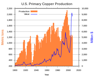
Copper mining in the United States has been a major industry since the rise of the northern Michigan copper district in the 1840s. In 2017 the United States produced 1.27 million metric tonnes of copper, worth $8 billion, making it the world's fourth largest copper producer, after Chile, China, and Peru. Copper was produced from 23 mines in the US. Top copper producing states in 2014 were Arizona, Utah, New Mexico, Nevada, and Montana. Minor production also came from Idaho, and Missouri. As of 2014, the US had 45 million tonnes of known remaining reserves of copper, the fifth largest known copper reserves in the world, after Chile, Australia, Peru, and Mexico.

Uranium mining in Colorado, United States, goes back to 1872, when pitchblende ore was taken from gold mines near Central City, Colorado. The Colorado uranium industry has seen booms and busts, but continues to this day. Not counting byproduct uranium from phosphate, Colorado is considered to have the third largest uranium reserves of any US state, behind Wyoming and New Mexico.
Temagamite is a bright white palladium mercury telluride mineral with a hardness of 2 1⁄2 on the Mohs scale. Its chemical formula is Pd3HgTe3. It was discovered at the Temagami Mine on Temagami Island, Lake Temagami in 1973, and it represents a rare mineral in the Temagami Greenstone Belt.

There is evidence of prehistoric human habitation in the region known today as the U.S. state of Wyoming stretching back roughly 13,000 years. Stone projectile points associated with the Clovis, Folsom and Plano cultures have been discovered throughout Wyoming. Evidence from what is now Yellowstone National Park indicates the presence of vast continental trading networks since around 1000 years ago. The Union Pacific Railroad played a central role in the European settlement of the area. Wyoming became a U.S. territory in 1868 and became the 44th U.S. state in 1890. It was the first state to grant women the right to vote, in 1869.
Shoshonite is a type of igneous rock. More specifically, it is a potassium-rich variety of basaltic trachyandesite, composed of olivine, augite and plagioclase phenocrysts in a groundmass with calcic plagioclase and sanidine and some dark-colored volcanic glass. Shoshonite gives its name to the shoshonite series and grades into absarokite with the loss of plagioclase phenocrysts and into bannakite with an increase in sanidine. Shoshonite was named by Iddings in 1895 for the Shoshone River in Wyoming.
The Seminoe Mountains greenstone belt represents a fragment of an Archean greenstone terrane within the Wyoming craton. The greenstone belt was mapped by Hausel, who identified significant gold anomalies at Bradley Peak in banded iron formation, quartz veins and in a large altered zone of metabasalts. Mapping differentiated three mappable units that included the Bradley Peak metavolcanics, the Seminoe Formation and the Sunday Morning metasediments.

The Roșia Poieni copper mine is a large open pit copper mine in the centre of Romania, 90 km northwest of Alba Iulia and 484 km north of the capital, Bucharest. Geographically the mine is located in the Apuseni Mountains, 7 km (4.3 mi) south of the Arieş River in Lupșa commune. The access to the site is made through a south-west industrial haul road from Cornii Valley that crosses the National Road no. 74 Alba-Iulia – Zlatna – Abrud when entering Abrud and through a north industrial haul road from Musca Valley that crosses the National Road no. 75 Campeni – Turda in Musca village, Lupșa commune.

The Sierra Madre Range is a mountain range in the western United States, located in south-central Wyoming and north-central Colorado. Geologically, it may be considered an extension of the Park Range of Colorado. South of the Great Divide Basin, the US Continental Divide runs along the Sierre Madre high points. Its western basins drain into the Colorado River and its eastern into the North Platte River. Buck Mountain is the highest peak in the range and lies within Colorado. Bridger Peak is its highest elevation on the Wyoming side of the range.

The Ferris-Haggerty Mine Site was one of the richest components of the Grand Encampment Mining District in Carbon County, Wyoming. The site was first exploited by Ed Haggerty, a prospector from Whitehaven, England, in 1897 when he established the Rudefeha Mine that would later be known as the Ferris-Haggerty Mine on a rich deposit of copper ore. Haggerty was backed by George Ferris and other investors, of whom all but Ferris dropped out. The partners sold an interest to Willis George Emerson, who raised investment funding for improvements to the mine. These facilities included an engineering feat of its' day by developing a 16-mile (26 km) aerial tramway to carry high grade copper mined at the Ferris-Haggerty Mine (FHM) over the Continental Divide to the smelter in Encampment. The tramway was longest aerial tramway the world had ever seen. The mine was eventually acquired by the North American Copper Company for $1 million. By 1904 the mine had produced $1.4 million in copper ore, and was sold to the Penn-Wyoming Copper Company. However, even with copper prices peaking in 1907, the company had difficulty making a profit from the remote mine site. The company was over-capitalized and under-insured and was suffered devastating fires at the mine site in March 1906 and May 1907 which halted production. Business disputes and a fall in copper prices prevented re-opening of the mine even after it was rebuilt. Machinery was salvaged after a foreclosure in 1913. A total of 23 million pounds of copper ore was extracted from the mine during its life.
The Namaqualand 0-6-2 Clara Class of 1890 was a South African steam locomotive from the pre-Union era in the Cape of Good Hope.
The Boston Wyoming Smelter Site was the site of a copper smelter that processed ores from the nearby Grand Encampment Mining District in Carbon County, Wyoming in the early 20th century. The site includes the former town of Rudefeha and is near Encampment, Wyoming. The smelter was constructed in 1902 by Grand Encampment promoter Willis George Emerson, connected to the main Ferris-Haggerty Mine location by a 16-mile (26 km) aerial tram over the Continental Divide. The smelter initially produced matte, an intermediate product in copper refining. In 1903 it was upgraded to produce blister copper. Power for the blowers needed for the blister refining process came from a water turbine at the end of a 4-foot (1.2 m) diameter wood-stave pipe from the South Fork of the Encampment River, 4 miles (6.4 km) away. The smelter could process 300 to 400 tons of ore a day.


