Calpet, Wyoming

Last updated
Calpet, Wyoming
WYMap-doton-Calpet.PNG
Location of Calpet, Wyoming
Coordinates: 42°17′0″N110°16′24″W / 42.28333°N 110.27333°W / 42.28333; -110.27333 Coordinates: 42°17′0″N110°16′24″W / 42.28333°N 110.27333°W / 42.28333; -110.27333
Country United States
State Wyoming
County Sublette
Area
  Total4.6 sq mi (12.0 km2)
  Land4.6 sq mi (12.0 km2)
  Water0.0 sq mi (0.0 km2)
Elevation
6,827 ft (2,081 m)
Population
 (2000)
  Total7
  Density1.5/sq mi (0.6/km2)
Time zone UTC-7 (Mountain (MST))
  Summer (DST) UTC-6 (MDT)
Area code(s) 307
FIPS code 56-11845 [1]
GNIS feature ID1586282 [2]

Calpet is an unincorporated community in Sublette County, Wyoming, United States. The population was 7 at the 2000 census, when it was a census-designated place (CDP).

Contents

The community was named for the California Petroleum Company. [3]

Geography

Calpet is located at 42°17′0″N110°16′24″W / 42.28333°N 110.27333°W / 42.28333; -110.27333 (42.283324, -110.273239). [4]

According to the United States Census Bureau, in 2000 the CDP has a total area of 4.6 square miles (12.0 km2), all land.

Demographics

As of the census [1] of 2000, there were 7 people, 3 households, and 2 families residing in the CDP. The population density was 1.5 people per square mile (0.6/km2). There were 5 housing units at an average density of 1.1/sq mi (0.4/km2). The racial makeup of the CDP was 100.00% White.

There were 3 households, out of which 66.7% had children under the age of 18 living with them, 33.3% were married couples living together, and 33.3% were non-families. No households were made up of individuals, and none had someone living alone who was 65 years of age or older. The average household size was 2.33 and the average family size was 2.50.

In the CDP the population was spread out, with 28.6% under the age of 18 and 71.4% from 45 to 64. The median age was 50 years. For every 100 females, there were 250.0 males. For every 100 females age 18 and over, there were 150.0 males.

The median income for a household in the CDP was $53,750, and the median income for a family was $53,750. Males had a median income of $43,750 versus $11,250 for females. The per capita income for the CDP was $17,067. None of the population or the families were below the poverty line.

Education

Public education in the town of Big Piney is provided by Sublette County School District #9.

Related Research Articles

Mendeltna, Alaska CDP in Alaska, United States

Mendeltna is a census-designated place (CDP) in Valdez-Cordova Census Area, Alaska, United States. The population was 39 at the 2010 census, down from 63 in 2000.

Canyon Day, Arizona Census-designated place in Arizona, United States

Canyon Day is a census-designated place (CDP) in Gila County, Arizona, United States, on the Fort Apache Indian Reservation. The population was 1,209 at the 2010 census.

Paxton, California census-designated place in California, United States

Paxton is a census-designated place (CDP) in Plumas County, California, United States. The population was 14 at the 2010 census, down from 21 at the 2000 census.

Millis-Clicquot, Massachusetts CDP in Massachusetts, United States

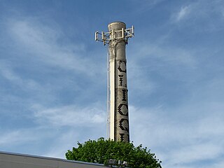
Millis-Clicquot is a census-designated place (CDP) in the town of Millis in Norfolk County, Massachusetts, United States. The population was 4,403 at the 2010 census. The name "Clicquot" comes from the now-defunct Clicquot Club Company, a beverage manufacturer that was founded in the area in 1881.

Tucker, Mississippi CDP in Mississippi, United States

Tucker is a census-designated place (CDP) in Neshoba County, Mississippi. It is one of the eight communities of the Mississippi Band of Choctaw Indians Reservation and the population is 93% Choctaw. The population was 534 at the 2000 census.

Inverness, Montana CDP in Montana, United States

Inverness is a census-designated place (CDP) in Hill County, Montana, United States. The population was 55 at the 2010 census.

Billington Heights, New York Census-designated place in New York, United States

Billington Heights is a hamlet and census-designated place (CDP) in the towns of Elma and Aurora in Erie County, New York, United States. The population was 1,685 at the 2010 census. It is part of the Buffalo–Niagara Falls Metropolitan Statistical Area.

Simms, Oklahoma CDP in Oklahoma, United States

Simms is a census-designated place (CDP) in Muskogee County, Oklahoma, United States. The population was 295 at the 2000 census.

Stony Point, Oklahoma CDP in Oklahoma, United States

Stony Point is a census-designated place (CDP) in Sequoyah County, Oklahoma, United States. It is part of the Fort Smith, Arkansas-Oklahoma Metropolitan Statistical Area. The population was 177 at the 2000 census.

Marion, Oregon Census-designated place in Oregon, United States

Marion is an unincorporated community in Marion County, Oregon, United States. For statistical purposes, the United States Census Bureau has defined Marion as a census-designated place (CDP). The census definition of the area may not precisely correspond to local understanding of the area with the same name. The population was 313 at the 2010 census. Marion is part of the Salem Metropolitan Statistical Area.

Lipscomb, Texas CDP in Texas, United States

Lipscomb is a census-designated place (CDP) in, and the county seat of, Lipscomb County, Texas, United States. The population was 37 at the 2010 census.

San Isidro, Texas CDP in Texas, United States

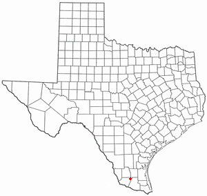
San Isidro is a census-designated place (CDP) in Starr County, Texas, United States. The population was 240 at the 2010 census. The town is named for St. Isidore the Laborer, the patron saint of farmers. A large Southwestern Barrel Cactus growing just east of town is said to be the largest in Texas.

Reserve, Wisconsin CDP in Wisconsin, United States

Reserve is a census-designated place (CDP) in the Town of Couderay, Sawyer County, Wisconsin, United States. The population was 429 at the 2010 census.

Fairview, Wyoming CDP in Wyoming, United States

Fairview is a census-designated place (CDP) in Lincoln County, Wyoming, United States. The population was 275 at the 2010 census.

Taylor, Wyoming CDP in Wyoming, United States

Taylor is a census-designated place (CDP) in Lincoln County, Wyoming, United States. The population was 90 at the 2010 census.

Boulder, Wyoming CDP in Wyoming, United States

Boulder is a census-designated place (CDP) in Sublette County, Wyoming, United States. The population was 170 at the 2010 census.

Cora, Wyoming CDP in Wyoming, United States

Cora is a census-designated place (CDP) in Sublette County, Wyoming, United States. The population was 142 at the 2010 census.

Daniel, Wyoming CDP in Wyoming, United States

Daniel is a census-designated place in Sublette County, Wyoming, United States. The population was 150 at the 2010 census.

Moose Wilson Road, Wyoming CDP in Wyoming, United States

Moose Wilson Road is a census-designated place (CDP) in Teton County, Wyoming, United States. The population was 1,821 at the 2010 census. It is part of the Jackson, WY–ID Micropolitan Statistical Area.

Lonetree, Wyoming CDP in Wyoming, United States

Lonetree is a census-designated place (CDP) in Uinta County, Wyoming, United States. The population was 49 at the 2010 census.

References

  1. 1 2 "U.S. Census website". United States Census Bureau . Retrieved 2008-01-31.
  2. "US Board on Geographic Names". United States Geological Survey. 2007-10-25. Retrieved 2008-01-31.
  3. Stewart, George R. (1970). American place-names; a concise and selective dictionary for the continental United States of America . New York: Oxford University Press.
  4. "US Gazetteer files: 2010, 2000, and 1990". United States Census Bureau. 2011-02-12. Retrieved 2011-04-23.