
Sublette County is a county in the U.S. state of Wyoming. As of the 2020 United States Census, the population was 8,728. The county seat is Pinedale. It is a sparsely populated rural county in western Wyoming, along the Green River.

Big Piney is a town in Sublette County, Wyoming, United States. The population was 552 at the 2010 census.

Bondurant is a census-designated place (CDP) in Sublette County, Wyoming, United States. The population was 93 at the 2010 census. The town was named after B. F. Bondurant.

Cora is a census-designated place (CDP) in Sublette County, Wyoming. The population was 114 at the 2020 census.

Daniel is a census-designated place in Sublette County, Wyoming, United States. The population was 150 at the 2010 census.

Pinedale is a town in and the county seat of Sublette County, Wyoming, United States. The population was 2,030 at the 2010 census. Pinedale is an important hunting outfitting town and a gateway to the Wind River Mountains. It is also a major gateway to the Jackson Hole area in Wyoming. Additionally, Pinedale is near several large natural gas fields, including the Pinedale Anticline and Jonah Field. Attractions include the Museum of the Mountain Man, Green River Rendezvous Days, White Pine Ski Area, the Pinedale Aquatic Center and the Town Park System along the Pine Creek Corridor in the middle of town. The mayor is Matt Murdock, who was elected in 2018.

The Big Sandy River is a 141-mile-long (227 km) tributary of the Green River in Wyoming in the United States.
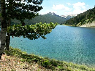
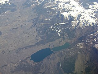
There are several lakes named Mud Lake within the U.S. state of Wyoming.
The Wyoming Range is a mountain range located in western Wyoming. It is a range of the Rocky Mountains that runs north-south near the western edge of the state. Its highest peak is Wyoming Peak, which stands at 11,383 feet (3,470 m) above sea-level. The range is sometimes referred to as The Wyomings.

The Emigrant Trail in Wyoming, which is the path followed by Western pioneers using the Oregon, California, and Mormon Trails, spans 400 miles (640 km) through the U.S. state of Wyoming. The trail entered from Nebraska on the eastern border of the state near the present day town of Torrington and exited on the western border near the towns of Cokeville and Afton. An estimated 350,000 to 400,000 settlers traveled on the trail through Wyoming between 1841 and 1868. All three trails follow the same path through most of the state. The Mormon Trail splits at Fort Bridger and enters Utah, while the Oregon and California Trails continue to Idaho.
The Bridger National Forest was first established by the U.S. Forest Service on July 1, 1911 in Wyoming with 577,580 acres (2,337.4 km2) from part of Bonneville National Forest. On May 14, 1923 Bridger was transferred Wyoming National Forest, and the name was discontinued. On March 10, 1943 Wyoming was renamed Bridger. In 1973 Bridger National Forest was administratively combined with Teton National Forest, creating Bridger-Teton National Forest. In descending order of land area, Bridger National Forest lands are located in Sublette, Lincoln, Fremont, and Teton counties. There are local ranger district offices in Afton, Big Piney, Kemmerer, and Pinedale. Its administrative headquarters reside in Jackson, Wyoming as part of the combined Bridger-Teton National Forest. Its current area of 1,736,075 acres (7,025.65 km²) represents 51.02% of the combined Bridger-Teton's area of 3,402,644 acres (13,770.01 km²). The forest includes all of the National Wilderness Preservation System's officially designated Bridger Wilderness.
Sublette County School District #1 is a public school district based in Pinedale, Wyoming, United States.
The New Fork River is the uppermost major tributary of the Green River in Wyoming, flowing about 70 miles (110 km) entirely within Sublette County. It drains an arid farming region of southwestern Wyoming south of the Wind River Range.
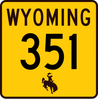
Wyoming Highway 351 (WYO 351) is a 24.18-mile-long (38.91 km) east-west Wyoming state road located in central Sublette County. It connects U.S. Route 189 with US 191 and mainly serves the hugely important Big Piney-Rock Springs corridor.
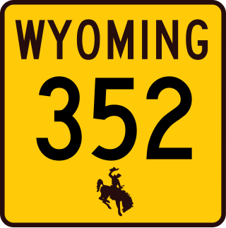
Wyoming Highway 352 is a 25.31-mile-long (40.73 km) north-south Wyoming state road located in northern Sublette County. Highway 352 provides access Cora and Bridger National Forest.

The ENP Bridge over Green River is a historic bridge located near Daniel, Wyoming, which carries Sublette County Road CN23-145 across the Green River. The Western Bridge and Construction Company built the bridge circa 1905. The 221-foot-11-inch (67.64 m) bridge has two spans, both Pratt trusses; the longer span is a Pratt through truss, while the shorter is a Pratt pony truss. The use of both through and pony trusses in the same bridge was uncommon in Wyoming, and the bridge is the only surviving example of a Pratt truss bridge in this style.
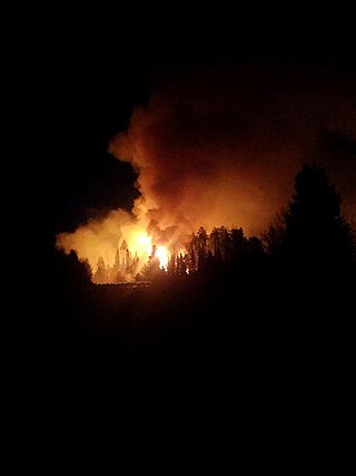
The Roosevelt Fire was a wildfire in Bridger-Teton National Forest in the U.S. state of Wyoming. The ignition point was near the head of the Hoback River in the Wyoming Range 32 miles (51 km) south of the town of Jackson, Wyoming. The fire was reported by a hunting party on September 15, 2018; the party attempted to leave the area on September 16, but ideal fire conditions allowed for rapid growth and two of them were forced to jump into a creek to escape the flames. The hunters, a father and son, were transported to a local hospital then to a burn center in Salt Lake City. By Monday September 17, the fire had moved several miles east, triggering evacuations in residential areas northwest of Pinedale, Wyoming in its path. By September 18, the fire was moving northeast, prompting the evacuation of the Hoback Ranches subdivision south of the town of Bondurant for a total of 230 homes evacuated. By the morning of September 19, the fire had expanded to over 25,000 acres (10,000 ha). As of September 20, the fire began to burn outside the national forest to the edge of the Hoback Ranches; and was 3 mi (4.8 km) west of U.S. Route 189/191, leading officials to declare that further encroachment toward the highway would lead them to shut down a section of it for public safety. By September 21, more than a half dozen helicopters were assigned to and several air tankers were dropping retardant on the fire which was reported to have grown to 34,411 acres (13,926 ha). On September 23 the fire was spreading rapidly to the east and north forcing authorities to close a fifty mile stretch of U.S. route 189/191 from mile marker 110 to 160 to clear the road for evacuations underway, however the highway was reopened the following day.

Mount Geikie is a 12,378-foot-elevation (3,773-meter) mountain summit in Sublette County, Wyoming, United States.
