Related Research Articles
The Appalachian Trail, also called the A.T., is a hiking trail in the Eastern United States, extending almost 2,200 miles (3,540 km) between Springer Mountain in Georgia and Mount Katahdin in Maine, and passing through 14 states. The Appalachian Trail Conservancy claims the Appalachian Trail to be the longest hiking-only trail in the world. More than three million people hike segments of the trail each year.
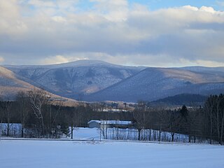
Mount Greylock in northwest Massachusetts is the highest point in the state at 3,489 feet. The peak played a role in early American literature, and is part of the Taconic Mountains, which are geologically distinct from the nearby Berkshires and Green Mountains. Expansive views and a small area of sub-alpine forest characterize its upper reaches. A seasonal automobile road crosses the summit area near three structures from the 1930s which together constitute a small, "National Historic District." Various hiking paths including the Appalachian Trail traverse the area, which is part of the larger Mount Greylock State Reservation.

The Presidential Range is a mountain range located in the White Mountains of the U.S. state of New Hampshire. Containing the highest peaks of the Whites, its most notable summits are named for American presidents, followed by prominent public figures of the 18th and 19th centuries. The Presidential Range is notorious for having some of the worst weather on Earth, mainly because of the unpredictability of high wind speeds and whiteout conditions on the higher summits. Because of the poor weather conditions, the Presidential Range is often used for mountaineering training for those who go on to climb some of the world's highest mountains, including K2 and Everest.

The Berkshires are a highland region located in western Massachusetts and northwestern Connecticut in the United States. Generally, "Berkshires" may refer to the range of hills in Massachusetts that lie between the Housatonic and Connecticut Rivers. Highlands of northwest Connecticut may be seen as part of the Berkshires and sometimes called the Northwest Hills or Litchfield Hills. The segment of the Taconic Mountains in Massachusetts is often considered a part of the Berkshires, although they are geologically separate and are a comparatively narrow range along New York's eastern border.

The Green Mountains are a mountain range in the U.S. state of Vermont and are a subrange of the Appalachian Mountains. The range runs primarily south to north and extends approximately 250 miles (400 km) from the border with Massachusetts to the border with Quebec, Canada. The part of the same range that is in Massachusetts and Connecticut is known as The Berkshires or the Berkshire Hills and the Quebec portion is called the Sutton Mountains, or Monts Sutton in French.

Bear Mountain is a peak of the southern Taconic Mountains in Salisbury, Connecticut. At 2,316 feet (706 m), Bear Mountain is the highest mountain that lies wholly within Connecticut. However, it is not the state highpoint: in the 1940s, the United States Geological Survey determined that the highest elevation in the state, at 2,380 feet (725 m), was actually on the nearby Connecticut-Massachusetts border, on the southern slope of Massachusetts’ Mount Frissell. There is a stone monument on the Bear Mountain summit. The Appalachian Trail crosses the mountain in a generally north-south direction.

The Taconic Mountains are a 150-mile-long sub-range of the Appalachian Mountains lying on the eastern border of New York State and adjacent New England. The range, which played a role in the history of geological science, is separated from the Berkshires and Green Mountains to the east by a series of valleys, principally those of the Housatonic River, Battenkill River and Otter Creek. The Taconics' highest point is Mount Equinox in Vermont at 3,840 feet (1,170 m); among many other summits are Dorset Mountain, Mount Greylock and Mount Everett.

Mount Frissell, 2,454 feet (748 m), which straddles the border of southwest Massachusetts and northwest Connecticut, is part of the Taconic Range. Frissell's south slopes include the highest point in Connecticut, a popular destination for highpointers.

The Metacomet-Monadnock Trail is a 114-mile-long (183 km) hiking trail that traverses the Metacomet Ridge of the Pioneer Valley region of Massachusetts and the central uplands of Massachusetts and southern New Hampshire. Although less than 70 miles (110 km) from Boston and other large population centers, the trail is considered remarkably rural and scenic and includes many areas of unique ecologic, historic, and geologic interest. Notable features include waterfalls, dramatic cliff faces, exposed mountain summits, woodlands, swamps, lakes, river floodplain, farmland, significant historic sites, and the summits of Mount Monadnock, Mount Tom and Mount Holyoke. The Metacomet-Monadnock Trail is maintained largely through the efforts of the Western Massachusetts Chapter of the Appalachian Mountain Club (AMC). Much of the trail is a portion of the New England National Scenic Trail.
The Appalachian National Scenic Trail spans 14 U.S. states over its roughly 2,200 miles (3,500 km): Georgia, North Carolina, Tennessee, Virginia, West Virginia, Maryland, Pennsylvania, New Jersey, New York, Connecticut, Massachusetts, Vermont, New Hampshire, and Maine. The southern end is at Springer Mountain, Georgia, and it follows the ridgeline of the Appalachian Mountains, crossing many of its highest peaks and running almost continuously through wilderness before reaching the northern end at Mount Katahdin, Maine.

Mount Hight is a mountain located in Coos County, New Hampshire. The mountain is part of the Carter-Moriah Range of the White Mountains, which runs along the eastern-northeastern side of Pinkham Notch. Mount Hight is flanked on the north by South Carter Mountain across Zeta Pass, and on the southwest by Carter Dome.

Mount Bigelow is a long mountain ridge with several summits. It is located in Franklin County and Somerset County, Maine. It is one of Maine's highest summits. The mountain is named after Major Timothy Bigelow who climbed the rugged summit in late October 1775 "for the purpose of observation." Major Bigelow was one of Colonel Benedict Arnold's four division commanders during the 1775 Invasion of Canada. The expeditionary force passed along the Dead River on the northern edge of the Bigelow Range, now dammed into Flagstaff Lake.

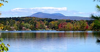
Mount Everett is the highest peak in the south Taconic Mountains, rising about 2,000 feet above its eastern footings in Sheffield, Mass. Its summit area is notable for expansive vistas and an unusual dwarf forest of pitch pine and oak. The Appalachian Trail traverses Mount Everett, which prior to the 20th century was called "Dome of the Taconics." Reaching 2,602 feet above sea level, Everett dominates much local scenery of the Housatonic Valley.

The Holyoke Range or Mount Holyoke Range is a traprock mountain range located in the Connecticut River Valley of Massachusetts. It is a subrange of the narrow, linear Metacomet Ridge that extends from Long Island Sound near New Haven, Connecticut north through the Connecticut River Valley of Massachusetts to the Vermont border. It is also a subrange of the Appalachian Mountains. A popular hiking destination, the range is known for its anomalous east–west orientation, high ledges and its scenic character. It is also notable for its unique microclimate ecosystems and rare plant communities, as well as significant historic sites, such as the Mount Holyoke Summit House and the Horse Caves.

Mount Norwottuck or Mount Norwottock, 1,106 feet (337 m) above sea level, is the highest peak of the Holyoke Range of traprock mountains located in the Connecticut River Valley of Massachusetts and part of the greater Metacomet Ridge which stretches from Long Island Sound to nearly the Vermont border. The peak rises steeply from the valley 1,000 feet (300 m) below and offers sweeping views of the surrounding countryside. It is located within the towns of Amherst and Granby, Massachusetts.
Bare Mountain, 1,014 feet (309 m) above sea level, is a prominent peak of the Holyoke Range of traprock mountains located in the Connecticut River Valley of Massachusetts, and part of the greater Metacomet Ridge that stretches from Long Island Sound to nearly the Vermont border. The peak rises steeply from the river valley 1,000 feet (300 m) below; its bald summit offers sweeping views. Bare Mountain is located within the towns of Amherst and South Hadley, Massachusetts. Part of its northeastern flanks are in Hadley and part of its southern flanks are in Granby. It is traversed by the 110-mile (180 km) Metacomet-Monadnock Trail.
Alander Mountain is 2,241-foot-tall (683 m) part of the south Taconic Mountains in southwest Massachusetts and adjacent New York. The summit is grassy and covered with scrub oak and shrubs; the sides of the mountain are heavily forested. Several trails traverse Alander Mountain, most notably the 15.7 mi (25.3 km) South Taconic Trail, which passes just beneath the summit.

Mount Race, 2,365 feet (721 m), is a mountain in Berkshire County, Massachusetts. It shares many characteristics with the slightly higher Mount Everett about a mile to the north. Part of the Taconic Mountains, Race is known for its waterfalls, an eastern escarpment of nearly 2,000 feet, and expansive views. The Appalachian Trail crosses its summit, which has an open forest of dwarf pitch pine and scrub oak.
Located in Berkshire County, Saddle Ball Mountain is the 2nd highest peak in the Commonwealth of Massachusetts.

Mount Fitch is the third-highest peak in the Commonwealth of Massachusetts at 3,110 feet (950 m). It is located on the ridge between Mount Greylock at 3,491 feet to its south and Mount Williams at 2,956 feet to its north. The peak sits in the northwest corner of the Town of Adams in Berkshire County. The forested summit is approximately 123 yards (112 m) due west of a local high-point on the Appalachian Trail. Mount Fitch does not meet the Appalachian Mountain Club's prominence criterion of 200 vertical feet of separation from adjacent peaks as outlined in New England's Four-thousand footers list. Currently there is no side-spur trail or signage directing a hiker to the summit of Mt. Fitch from the Appalachian Trail; however, there is a wooden placard at the summit itself. The top is infrequently visited by hikers due to its anonymity, the bushwhack necessary to reach the top and the viewless summit.