Barnstable County was formed as part of the Plymouth Colony on June 2, 1685, including the towns of Falmouth, Sandwich, and others lying to the east and north on Cape Cod. Plymouth Colony was merged into the Province of Massachusetts Bay in 1691.
History
Giovanni da Verrazzano
Cape Cod is described in a letter from the Italian explorer Giovanni da Verrazzano to Francis I of France, relating the details of a voyage to the New World made on behalf of the French crown in the ship Dauphine, the only surviving of a fleet of four.[3] Sailing from Madeira in 1524, the Dauphine made land in North Carolina in March. It sailed north to Newfoundland, mapping the coast and interviewing the natives, whom he found friendly south of the cape, but unfriendly north of it. To the north of an island that reminded Verrazzano of Rhodes, the Dauphine made its way with difficulty over shoals "never less than three feet deep" extending "from the continent fifty leagues out to sea," which Brevoort, based on their extent, has identified as Nantucket Shoals.[4] Verrazzano called them Armellini. On the other side was a promontory, Pallavisino, which is probably the cape,[4] as they sailed along it for "fifty leagues." Details of the north end are not given, but subsequently they came to a "high country, full of very dense forests, composed of pines," which, according to Brevoort and others, resembles the coast of Maine.[4]
Bartholomew Gosnold
After Verrazzano, what is now the eastern United States acquired the map label of New France, but France had no way to develop it. Scattered colonies in the wilderness of a few dozen men could not be supported until the foundation of Quebec in 1608. Meanwhile, the paper claim did not deter entrepreneurs. In March 1602, Bartholomew Gosnold set sail from Falmouth, Cornwall, in the ship, Concord, transporting a crew of eight, an exploration party of 12, and 20 colonists, with the intent of establishing a trading post in the New World. Intersecting the coast of Maine, they turned to the south, encountered what appeared to be an island, and dropped anchor in Provincetown Harbor. Gosnold at first called the land Shoal Hope, but after discovering it was a cape, and acquiring a hold full of cod from the abundant schools in Cape Cod Bay, he changed the name to Cape Cod.[5]
Gosnold explored the cape, establishing good relations with the natives there, approximately 1500 members of the Nauset Tribe, closely related in language and custom to the Wampanoag people of the mainland, and under their sovereignty. John Brereton, chaplain of the expedition, reported that they were dark-skinned, customarily nude except for deerskins over the shoulders and sealskins around the waist, and wore their long, black hair up in a knot. They painted their bodies. Some knew a few English words, which is something of a historical problem, as Gosnold and his companions are believed to have been the first English to land in America.[6] Gosnold made a point of describing how healthy the people appeared.
Subsequently, Gosnold sailed around the cape to discover an island, "full of wood, vines, gooseberry bushes, whortleberries, raspberries, eglantines, etc.," as well as large numbers of shore birds. He named it Martha's Vineyard after his daughter. Another island nearby, Cuttyhunk Island, he named Elizabeth Island, in honor of Elizabeth I of England, from which the Elizabeth Islands take their name. He intended to place a trading post there, but when the time came for the return voyage, the colonists decided not to remain. Gosnold ventured a second time to the New World in 1608 as Captain John Smith's second in command of the Jamestown expedition. After three months there, he died of malaria.[5]
Martin Pring
In 1603, another mercantile expedition set sail from Bristol, England, in two ships, the Speedwell and the Discoverer, commanded by a 23-year-old captain, Martin Pring. Elizabeth I had died two weeks earlier, but Pring had secured permission from Sir Walter Raleigh, who held from the queen exploration rights to all of North America.
Geography
According to the U.S. Census Bureau, the county has a total area of 1,306 square miles (3,380km2), of which 394 square miles (1,020km2) is land and 912 square miles (2,360km2) (70%) is water.[7] It is the second-largest county in Massachusetts by total area. It has approximately 550 miles (890km) of shoreline.
Barnstable County is not co-extensive with Cape Cod. The latter is a geophysical term defined by its insular or peninsular landmass. According to Freeman, it is a "long, irregular peninsula" between 65 and 75mi (105 and 121km), measured along the north or the south shores respectively, and between 5 and 20mi (8.0 and 32.2km) wide. Originally, he points out, only the tip was considered the cape, but as it was settled the name extended from its tip to the shortest line across the isthmus.[8] Barnstable County, on the other hand, is a geopolitical and legal term. It is the area contained within the borders of all cities and towns defined to be in the county by the Massachusetts General Court. These borders were located in multiple episodes of disputed legislation during the centuries since the foundation of Plymouth Colony.[9]
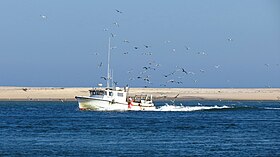
The main difference between Cape Cod and Barnstable County is the band of water up to several miles wide extending from the shoreline to the outermost county border. The offshore area contains significant maritime life, as well as being a recreational and transportational medium, and containing historical material lost with sunken ships.[10]
The highest elevation in the county is 306 feet (93m) on the summit of Pine Hill, located on Joint Base Cape Cod in Bourne. The lowest point is sea level.
Barnstable County is one of the oldest in the country, ranking in the top ten for highest median age (among those with at least 100,000 residents). The median age is 55 years old as of 2020 (whereas the median in the U.S. is 39 years old). It is the only county in the Northeast on the list.[11]
U.S. Decennial Census[13] 1790–1960[14] 1900–1990[15] 1990–2000[16] 2010–2020[17]
Age breakdown of residents in 2000
2000 census
As of the census[18] of 2000, there were 222,230 people, 94,822 households, and 61,065 families residing in the county. The population density was 562 peopleper square mile (217 people/km2). There were 147,083 housing units at an average density of 372 per square mile (144/km2). The racial makeup of the county was 94.23% White, 1.79% Black or African American, 0.56% Native American, 0.63% Asian, 0.02% Pacific Islander, 1.11% from other races, and 1.66% from two or more races. 1.35% of the population were Hispanic or Latino of any race. 24.0% were of Irish, 15.6% English, 9.4% Italian, 5.9% German and 5.0% "American" ancestry, 93.6% spoke English, 1.7% Portuguese, 1.4% Spanish and 1.0% French as their first language.
There were 94,822 households, out of which 24.30% had children under the age of 18 living with them, 52.20% were married couples living together, 9.40% had a female householder with no husband present, and 35.60% were non-families. 29.50% of all households were made up of individuals, and 14.40% had someone living alone who was 65 years of age or older. The average household size was 2.28 and the average family size was 2.82.
In the county, the population was spread out, with 20.40% under the age of 18, 5.20% from 18 to 24, 25.00% from 25 to 44, 26.20% from 45 to 64, and 23.10% who were 65 years of age or older. The median age was 45 years. For every 100 females, there were 89.90 males. For every 100 females age 18 and over, there were 86.10 males.
The median income for a household in the county was $45,933, and the median income for a family was $54,728. Males had a median income of $41,033 versus $30,079 for females. The per capita income for the county was $25,318. About 4.60% of families and 6.90% of the population were below the poverty line, including 8.60% of those under age 18 and 5.00% of those age 65 or over.
2010 census
As of the 2010 United States census, there were 215,888people, 95,755households, and 58,724families residing in the county.[19] The population density was 548.3 inhabitants per square mile (211.7/km2). There were 160,281 housing units at an average density of 407.1 per square mile (157.2/km2).[20] The racial makeup of the county was 92.7% white, 1.9% black or African American, 1.1% Asian, 0.6% American Indian, 1.5% from other races, and 2.2% from two or more races. Those of Hispanic or Latino origin made up 2.2% of the population.[19] In terms of ancestry, 27.0% were Irish, 19.2% were English, 11.4% were Italian, 11.4% were American, and 9.1% were German.[21]
Of the 95,755households, 22.2% had children under the age of 18 living with them, 48.3% were married couples living together, 9.6% had a female householder with no husband present, 38.7% were non-families, and 31.8% of all households were made up of individuals. The average household size was 2.21 and the average family size was 2.77. The median age was 49.9 years.[19]
The median income for a household in the county was $60,317 and the median income for a family was $75,056. Males had a median income of $53,480 versus $41,990 for females. The per capita income for the county was $35,246. About 5.0% of families and 7.2% of the population were below the poverty line, including 9.8% of those under age 18 and 5.6% of those age 65 or over.[22]
The ranking of unincorporated communities that are included on the list are reflective if the census designated locations and villages were included as cities or towns. Data is from the 2007–2011 American Community Survey 5-Year Estimates.[23][24][25]
Until the 1990s, Barnstable County was a stronghold of the Republican Party. The county voted for Republican presidential candidates in every election from 1876 to 1992, with the exception of 1912 (when the Progressive candidate won the county) and 1964. It has since come to favor the Democratic Party, supporting Democratic candidates in all presidential elections since 1992.
Voter registration
Voter registration and party enrollment as of February 2024[28]
Barnstable County is one of the last functioning counties in Massachusetts. County government consists of a legislative branch (Barnstable County Assembly of Delegates) and an executive branch (Barnstable County Commissioners).
Barnstable County Assembly of Delegates
The Assembly of Delegates is the legislative branch of Barnstable County. There are 15 towns located within Barnstable County, with each town represented on the Assembly. In 1989, by an Act of the Massachusetts General Court and confirmed by a majority of Barnstable County voters, the Barnstable County Home Rule Charter went into effect and the first session of the Assembly of Delegates convened. All legislative powers of the county are vested in the Assembly, which acts by ordinance and also adopts resolutions.
The Assembly of Delegates consists of 15 delegates, one representing each of the towns located in Barnstable County. A delegate's vote is weighted based on the population of his or her town. The town of Barnstable, for example, has the largest share of the vote, at 20.92%, and Truro has the smallest, at 0.93%.
Barnstable County Commissioners
There are three Barnstable County Commissioners who together act as the Executive Branch of county government. Each commissioner is elected at large and serves a four-year staggered term. Duties of the commissioners include direction of county agencies, preparation of budgets for submission to the Assembly, care of county property and finances, proposing ordinances to the Assembly, and appointment of the County Administrator.
Cities and towns have been legally incorporated as such under the laws of the State of Massachusetts. They include the entire territory of the state. A city may continue to name itself a town even though legally a city. Villages are subordinate to cities or towns. In addition to and not necessarily based on these legal municipalities are the arbitrary divisions of the United States Census Bureau. Villages are census divisions which may be used as special purpose municipalities or may have a greater sense of civic identity than their constituent town(s), but are not fully functioning municipal corporations. For example, the City of Barnstable has five fire districts that cover the seven villages - each village has its own fire department except that Centerville, Osterville and Marstons Mills have combined their efforts into the COMM Fire Department.
↑ A history of this extensive legislation through 1860 on a town-by-town basis can be found in Freeman 1862, passim
↑ In an effort to protect this area, Barnstable County created the Cape Cod Commission, giving it control over the oceanic waters within county jurisdiction, to exclude the bays and river mouths as well as the Cape Cod Canal. Its final plan, completed in 2011, includes maps showing the total extent of Barnstable County, most of which is oceanic, including most of Cape Cod Bay, half of upper Buzzard's Bay, and some of the waters to the south of the cape. "Cape Cod Ocean Management PLan"(PDF). Cape Cod Commission. October 13, 2011. p.33. Archived from the original(PDF) on June 17, 2013. Retrieved December 5, 2012.
Harwich is a New England town on Cape Cod, in Barnstable County in the state of Massachusetts in the United States. At the 2020 census it had a population of 13,440. Harwich experiences a seasonal increase to roughly 37,000. The town is a popular vacation spot, located near the Cape Cod National Seashore. Harwich's beaches are on the Nantucket Sound side of Cape Cod. Harwich has three active harbors. Saquatucket, Wychmere and Allen Harbors are all in Harwich Port. The town of Harwich includes the villages of Pleasant Lake, West Harwich, East Harwich, Harwich Port, Harwich Center, North Harwich and South Harwich.
Cape Cod is an arm-shaped peninsula extending into the Atlantic Ocean from the southeastern corner of Massachusetts, in the northeastern United States. Its historic, maritime character and ample beaches attract heavy tourism during the summer months. The name Cape Cod, coined in 1602 by Bartholomew Gosnold, is the ninth oldest English place-name in the U.S.
Provincetown is a New England town located at the extreme tip of Cape Cod in Barnstable County, Massachusetts, in the United States. A small coastal resort town with a year-round population of 3,664 as of the 2020 United States Census, Provincetown has a summer population as high as 60,000. Often called "P-town" or "Ptown", the locale is known for its beaches, harbor, artists, tourist industry, and as a popular vacation destination for the LGBT+ community.
Wellfleet is a town in Barnstable County, Massachusetts, United States, and is located halfway between the "tip" and "elbow" of Cape Cod. The town had a population of 3,566 at the 2020 census, which swells nearly sixfold during the summer. A total of 70% of the town's land area is under protection, and nearly half of it is part of the Cape Cod National Seashore. Wellfleet is famous for its oysters, which are celebrated in the annual October Wellfleet OysterFest.
Eastham is a town in Barnstable County, Massachusetts, United States, Barnstable County being coextensive with Cape Cod. The population was 5,752 at the 2020 census.
Mashpee is a town in Barnstable County, Massachusetts, United States, on Cape Cod. The population was 15,060 as of 2020. The town is the site of the headquarters and most members of the Mashpee Wampanoag Tribe, one of two federally recognized Wampanoag groups.
Truro is a town in Barnstable County, Massachusetts, United States, comprising two villages: Truro and North Truro. Located slightly more than 100 miles (160 km) by road from Boston, it is a summer vacation community just south of the northern tip of Cape Cod, in an area known as the "Outer Cape". English colonists named it after Truro in Cornwall, United Kingdom.
Bourne is a town in Barnstable County, Massachusetts, United States. The population was 20,452 at the 2020 census.
Brewster is a town in Barnstable County, Massachusetts, United States, Barnstable County being coextensive with Cape Cod. The population of Brewster was 10,318 at the 2020 census.
Falmouth is a town in Barnstable County, Massachusetts, United States. The population was 32,517 at the 2020 census, making Falmouth the second-largest municipality on Cape Cod after Barnstable. The terminal for the Steamship Authority ferries to Martha's Vineyard is located in the village of Woods Hole in Falmouth. Woods Hole also contains several scientific organizations such as the Woods Hole Oceanographic Institution (WHOI), the Marine Biological Laboratory (MBL), the Woodwell Climate Research Center, NOAA's Woods Hole Science Aquarium, and the scientific institutions' various museums.
Orleans is a town in Barnstable County, Massachusetts situated along Cape Cod. The population was 6,307 at the 2020 census.
Sandwich is a town in Barnstable County, Massachusetts and is the oldest town on Cape Cod. The town motto is Post tot Naufracia Portus, "after so many shipwrecks, a haven". The population was 20,259 at the 2020 census.
Hyannis is the largest of the seven villages in the town of Barnstable, Massachusetts, in the United States. It is the commercial and transportation hub of Cape Cod and was designated an urban area at the 1990 census. Because of this, many refer to Hyannis as the "Capital of the Cape". It contains a majority of the Barnstable Town offices and two important shopping districts: the historic downtown Main Street and the Route 132 Commercial District, including Cape Cod Mall and Independence Park, headquarters of Cape Cod Potato Chips. Cape Cod Hospital in Hyannis is the largest on Cape Cod.
Massachusetts's 16th congressional district is an obsolete district. It was first active 1803–1821 in the District of Maine and again active 1913–1933 in the Cape Cod region. It was eliminated in 1933 after the 1930 census. Its last congressman was Charles L. Gifford, who was redistricted into the 15th district.
Cape Cod Publishing Company, based in Orleans, Massachusetts, United States, was a publisher of weekly newspapers in the 1990s. It was created by Fidelity Investments as a holding company for newspapers acquired on Cape Cod, and eventually folded into Fidelity's Community Newspaper Company. CNC is now owned by GateHouse Media.
Barnstable is a town in the U.S. state of Massachusetts and the county seat of Barnstable County. Barnstable is the largest community, both in land area and population, on Cape Cod, and is one of thirteen Massachusetts municipalities that have been granted city forms of government by the Commonwealth of Massachusetts but wish to retain "the town of" in their official names. At the 2020 census it had a population of 48,916. The town contains several villages within its boundaries. Its largest village, Hyannis, is the central business district of the county and home to Barnstable Municipal Airport, the airline hub of Cape Cod and the islands of Martha's Vineyard and Nantucket. Additionally, Barnstable is a 2007 winner of the All-America City Award.
The Cape Libraries Automated Materials Sharing (CLAMS) library network is a non-profit consortium of 35 member libraries and 38 locations throughout Cape Cod, Martha's Vineyard, and Nantucket. Since it was founded in 1988, the number of items available has grown from 568,000 in 1991 to over 1.6 million in 2022. Deliveries of materials between member libraries and other library networks in Massachusetts through an interlibrary loan program are made by the Massachusetts Library System located in Waltham . The network uses the Koha Integrated Library System (ILS) for staff function workflows: acquisitions, cataloging, circulation, ILL, and serials and Aspen Discovery for their patron's Online Public Access Catalog (OPAC). The libraries provide access to reference databases, digital libraries, free music online, museum passes, genealogy, workshops, and other free services that vary from each location.
The Southeastern Massachusetts Resource Recovery Facility is a waste-to-energy and recycling facility located in Rochester, Massachusetts. It is currently owned by Covanta Energy.
The Cape Cod Regional Law Enforcement Council is a regional mutual aid facilitator formed by 43 police agencies in the area on or near Cape Cod, Massachusetts. It pools resources to provide SWAT, a Motor Vehicle Crash Reconstruction Team, a School Resource Officers’ Network and other units in the area.
Massachusetts Senate's Cape and Islands district in the United States is one of 40 legislative districts of the Massachusetts Senate. It covers 66.7% of Barnstable County, all of Dukes County, and all of Nantucket County population in 2010. Democrat Julian Cyr of Truro has represented the district since 2017. He is running unopposed for re-election in the 2020 Massachusetts general election.
This page is based on this Wikipedia article Text is available under the CC BY-SA 4.0 license; additional terms may apply. Images, videos and audio are available under their respective licenses.