Buzzards Bay, Massachusetts

Last updated
Buzzards Bay, Massachusetts
Buzzards Bay Railroad Bridge, Buzzards Bay MA.jpg
Barnstable County Massachusetts incorporated and unincorporated areas Buzzards Bay highlighted.svg
Location in Barnstable County and the state of Massachusetts.
Coordinates: 41°45′5″N70°36′49″W / 41.75139°N 70.61361°W / 41.75139; -70.61361 Coordinates: 41°45′5″N70°36′49″W / 41.75139°N 70.61361°W / 41.75139; -70.61361
Country United States
State Massachusetts
County Barnstable
Town Bourne
Settled1621
Area
[1]
  Total2.96 sq mi (7.66 km2)
  Land1.92 sq mi (4.96 km2)
  Water1.04 sq mi (2.70 km2)
Elevation
10 ft (3 m)
Population
 (2020)
  Total4,279
  Density2,233.30/sq mi (862.43/km2)
Time zone UTC-5 (Eastern (EST))
  Summer (DST) UTC-4 (EDT)
ZIP codes
02532, 02542
Area code 508
FIPS code 25-10015
GNIS feature ID0616369

Buzzards Bay is a census-designated place (CDP) in the town of Bourne in Barnstable County, Massachusetts. The population was 3,859 at the 2010 census. [2] It is the most populous of the five CDPs in Bourne.

Contents

Geography

Buzzards Bay is located at 41°45′5″N70°36′49″W / 41.75139°N 70.61361°W / 41.75139; -70.61361 (41.751364, -70.613563). [3] Along with Bournedale and Sagamore Beach, it is one of three communities in Barnstable County located on the mainland side of the Cape Cod Canal. Excessively drained sand underlies most of the community and the majority is mapped as Carver soil series. [4]

According to the United States Census Bureau, the CDP has a total area of 2.9 square miles (7.6 km2). 1.9 square miles (5.0 km2) of it is land and 1.0 square mile (2.6 km2) of it (34.75%) is water, [2] consisting primarily of Buttermilk Bay, an arm of Buzzards Bay that forms the western edge of the CDP.

Demographics

Historical population
CensusPop.
2020 4,279
U.S. Decennial Census [5]

As of the census [6] of 2000, there were 3,549 people, 1,216 households, and 795 families residing in the CDP. The population density was 692.1 per km2 (1,793.4 per mi2). There were 1,572 housing units at an average density of 306.5 per km2 (794.4 per mi2). The racial makeup of the CDP was 98.49% White, 0.01% African American, 0.54% Native American, 0.90% Asian, 0.99% from other races, and 0.07% from two or more races. Hispanic or Latino of any race were 0.04% of the population.

There were 1,216 households, out of which 24.2% had children under the age of 18 living with them, 48.3% were married couples living together, 12.7% had a female householder with no husband present, and 34.6% were non-families. 29.1% of all households were made up of individuals, and 12.2% had someone living alone who was 65 years of age or older. The average household size was 2.29 and the average family size was 2.78.

In the CDP, the population was spread out, with 15.9% under the age of 18, 23.0% from 18 to 24, 23.5% from 25 to 44, 20.7% from 45 to 64, and 17.0% who were 65 years of age or older. The median age was 35 years. For every 100 females, there were 121.7 males. For every 100 females age 18 and over, there were 123.5 males.

The median income for a household in the CDP was $99,750, and the median income for a family was $142,165. Males had a median income of $98,702 versus $68,801 for females. The per capita income for the CDPwas $88,304. About 0.4% of families and 1.7% of the population were below the poverty line, including 0.5% of those under age 18 and 1.2% of those age 65 or over.

History

Buzzards Bay was originally Wampanoag territory. The "buzzards" for which the town was named were most likely turkey vultures or ospreys. Buzzards Bay was settled by Europeans in 1621.

Among the community's most prominent residents was President of the United States Grover Cleveland, who maintained a "Summer White House" at his home at Agawam Point in Buzzards Bay. [7] Cleveland's home, a local landmark, was destroyed by fire on December 10, 1973. [7]

Culture

Buzzards Bay is home to the National Marine Life Center, a marine animal hospital, science, and education center dedicated to rehabilitating for release stranded sea turtles, and seals to advance scientific knowledge and education in marine wildlife health and conservation. Buzzards Bay is also home to the Massachusetts Maritime Academy.

Climate

In a typical year, Buzzards Bay, Massachusetts temperatures fall below 50F° for 167 days per year. Annual precipitation is typically 46.8 inches per year (the highest in the US) and snow covers the ground 43 days per year or 11.8% of the year (moderate in the US). It may be helpful to understand the yearly precipitation by imagining 9 straight days of moderate rain per year. The humidity is below 60% for approximately 27.6 days or 7.6% of the year. [8]

Education

Bourne Public Schools is the local public school district; it operates Bourne High School.

Area Catholic schools of the Roman Catholic Diocese of Fall River include: St. Francis Xavier School in Acushnet, St. Joseph School in Fairhaven, and St. Pius X School in South Yarmouth. Previously Buzzards Bay had its own Catholic grade school, St. Margaret Primary School, which closed in 2020 in the wake of the COVID-19 pandemic. St. Francis Xavier, St. Joseph, and St. Pius X took former St. Margaret students. [9]

See also

Related Research Articles

<span class="mw-page-title-main">Barnstable County, Massachusetts</span> County in Massachusetts, United States

Barnstable County is a county located in the U.S. state of Massachusetts. At the 2020 census, the population was 228,996. Its shire town is Barnstable. The county consists of Cape Cod and associated islands.

<span class="mw-page-title-main">East Sandwich, Massachusetts</span> Census-designated place in Massachusetts, United States

East Sandwich is a village and census-designated place (CDP) within the town of Sandwich in Barnstable County, Massachusetts, United States. The population was 3,940 at the 2010 census.

<span class="mw-page-title-main">Mashpee Neck, Massachusetts</span> Census-designated place in Massachusetts, United States

Mashpee Neck is a census-designated place (CDP) in the town of Mashpee in Barnstable County, Massachusetts, United States. The population was 1,000 at the 2010 census. It is the most populous of the seven CDPs in Mashpee.

<span class="mw-page-title-main">Monument Beach, Massachusetts</span> Census-designated place in Massachusetts, United States

Monument Beach is a census-designated place (CDP) in the town of Bourne in Barnstable County, Massachusetts, United States. The population was 2,790 at the 2010 census.

<span class="mw-page-title-main">North Falmouth, Massachusetts</span> Census-designated place in Massachusetts, United States

North Falmouth is a census-designated place (CDP) in the town of Falmouth in Barnstable County, Massachusetts, United States. The population was 3,084 at the 2010 census.

<span class="mw-page-title-main">Pocasset, Massachusetts</span> Census-designated place in Massachusetts, United States

The village of Pocasset is a census-designated place (CDP) in the town of Bourne in Barnstable County, Massachusetts, United States, located on Buzzards Bay. The population was 2,851 at the 2010 census.

<span class="mw-page-title-main">Popponesset, Massachusetts</span> Census-designated place in Massachusetts, United States

Popponesset is a census-designated place (CDP) in the town of Mashpee on Cape Cod in Barnstable County, Massachusetts, United States. The population was 220 at the 2010 census.

<span class="mw-page-title-main">Popponesset Island, Massachusetts</span> Census-designated place in Massachusetts, United States

Popponesset Island is an island and census-designated place (CDP) in the town of Mashpee in Barnstable County, Massachusetts, United States. The population was 26 at the 2010 census.

<span class="mw-page-title-main">Sagamore, Massachusetts</span> Census-designated place in Massachusetts, United States

Sagamore is a census-designated place (CDP) in the town of Bourne in Barnstable County, Massachusetts, United States. The population was 3,623 at the 2010 census. "Sagamore" was one of the words used by northeastern Native Americans to designate an elected chief or leader.

<span class="mw-page-title-main">Seconsett Island, Massachusetts</span> Census-designated place in Massachusetts, United States

Seconsett Island is a census-designated place (CDP) in the town of Mashpee in Barnstable County, Massachusetts, United States. The population was 100 at the 2010 census.

<span class="mw-page-title-main">West Falmouth, Massachusetts</span> Census-designated place in Massachusetts, United States

West Falmouth is a census-designated place (CDP) in the town of Falmouth in Barnstable County, Massachusetts, United States. The population was 1,738 at the 2010 census.

<span class="mw-page-title-main">Woods Hole, Massachusetts</span> Census-designated place in Massachusetts, United States

Woods Hole is a census-designated place in the town of Falmouth in Barnstable County, Massachusetts, United States. It lies at the extreme southwest corner of Cape Cod, near Martha's Vineyard and the Elizabeth Islands. The population was 781 at the 2010 census.

<span class="mw-page-title-main">Yarmouth Port, Massachusetts</span> Census-designated place in Massachusetts, United States

Yarmouth Port is a census-designated place (CDP) in the town of Yarmouth in Barnstable County, Massachusetts, United States. The population was 5,320 at the 2010 census.

<span class="mw-page-title-main">Bourne (CDP), Massachusetts</span> Census-designated place in Massachusetts, United States

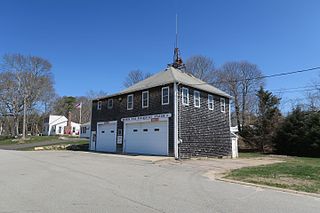
The village of Bourne is a census-designated place (CDP) in the town of Bourne in Barnstable County, Massachusetts, United States. The population was 1,418 at the 2010 census, out of 19,754 in the town of Bourne as a whole.

<span class="mw-page-title-main">Bourne, Massachusetts</span> Town in Massachusetts, United States

Bourne is a town in Barnstable County, Massachusetts, United States. The population was 20,452 at the 2020 census.

<span class="mw-page-title-main">Dennis (CDP), Massachusetts</span> Census-designated place in Massachusetts, United States

Dennis is a village and census-designated place (CDP) in the town of Dennis in Barnstable County, Massachusetts, United States. The population was 2,407 at the 2010 census. The CDP includes the populated places known as North Dennis and New Boston.

<span class="mw-page-title-main">Falmouth, Massachusetts</span> Town in Massachusetts, United States

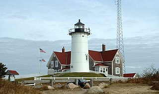
Falmouth is a town in Barnstable County, Massachusetts, United States. The population was 32,517 at the 2020 census, making Falmouth the second-largest municipality on Cape Cod after Barnstable. The terminal for the Steamship Authority ferries to Martha's Vineyard is located in the village of Woods Hole in Falmouth. Woods Hole also contains several scientific organizations such as the Woods Hole Oceanographic Institution (WHOI), the Marine Biological Laboratory (MBL), the Woodwell Climate Research Center, NOAA's Woods Hole Science Aquarium, and the scientific institutions' various museums.

<span class="mw-page-title-main">Orleans (CDP), Massachusetts</span> Census-designated place in Massachusetts, United States

Orleans is a census-designated place (CDP) in the town of Orleans in Barnstable County, Massachusetts, United States. The population was 1,621 at the 2010 census.

<span class="mw-page-title-main">Orleans, Massachusetts</span> Town in Massachusetts, United States

Orleans is a town in Barnstable County, Massachusetts situated along Cape Cod. The population was 6,307 at the 2020 census.

<span class="mw-page-title-main">Sandwich (CDP), Massachusetts</span> Census-designated place in Massachusetts, United States

Sandwich is a village and census-designated place (CDP) in the town of Sandwich in Barnstable County, Massachusetts, United States. The population was 2,962 at the 2010 census, out of a total 20,675 people in the town of Sandwich.

References

  1. "2020 U.S. Gazetteer Files". United States Census Bureau. Retrieved May 21, 2022.
  2. 1 2 "Geographic Identifiers: 2010 Demographic Profile Data (G001): Buzzards Bay CDP, Massachusetts". U.S. Census Bureau, American Factfinder. Archived from the original on February 12, 2020. Retrieved December 6, 2013.
  3. "US Gazetteer files: 2010, 2000, and 1990". United States Census Bureau. 2011-02-12. Retrieved 2011-04-23.
  4. "SoilWeb: An Online Soil Survey Browser | California Soil Resource Lab".
  5. "Census of Population and Housing". Census.gov. Retrieved June 4, 2016.
  6. "U.S. Census website". United States Census Bureau . Retrieved 2008-01-31.
  7. 1 2 "Rebuilding on a Historic Site," Cape Cod Times, Dec. 7, 2003.
  8. "Massachusetts Mortgage Calculator" . Retrieved November 8, 2022.
  9. "Coronavirus Impact: Coyle And Cassidy, St. Margaret Catholic Schools Closing For Good". WBZ CBS Boston. 2020-04-16. Retrieved 2020-06-26.

Commons-logo.svg Media related to Buzzards Bay, Massachusetts at Wikimedia Commons