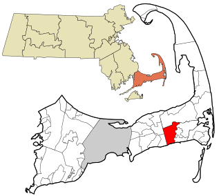
Harwich is a New England town on Cape Cod, in Barnstable County in the state of Massachusetts in the United States. At the 2020 census it had a population of 13,440. Harwich experiences a seasonal increase to roughly 37,000. The town is a popular vacation spot, located near the Cape Cod National Seashore. Harwich's beaches are on the Nantucket Sound side of Cape Cod. Harwich has three active harbors. Saquatucket, Wychmere and Allen Harbors are all in Harwich Port. The town of Harwich includes the villages of Pleasant Lake, West Harwich, East Harwich, Harwich Port, Harwich Center, North Harwich and South Harwich.

Barnstable County is a county located in the U.S. state of Massachusetts. At the 2020 census, the population was 228,996. Its county seat is Barnstable. The county consists of Cape Cod and associated islands.

Dennis Port is a census-designated place (CDP) in the town of Dennis in Barnstable County, Cape Cod, Massachusetts. At the 2010 census, its population was 3,162.

East Harwich is a census-designated place (CDP) and village in the town of Harwich in Barnstable County, Massachusetts, United States. The population was 4,872 at the 2010 census.

Harwich Center is a census-designated place (CDP) in the town of Harwich in Barnstable County, Massachusetts, United States. The population was 1,798 at the 2010 census.
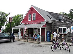
Harwich Port is a small affluent seaside community and census-designated place (CDP) situated along the Nantucket Sound in the town of Harwich in Barnstable County, Massachusetts, United States. It is named after the port of Harwich in Essex, England. As of the 2010 census, the CDP had a population of 1,644. It is a popular vacation spot on Cape Cod and is home to the Wychmere Beach Club and the Allen Harbor Yacht Club. Also, one of its popular mottos is "Three Harbors, One Port," referencing to Saquatucket, Wychmere, and Allen Harbor, which are all located in Harwich Port. Well known residents include Bill O'Brien, former head coach and general manager of the Houston Texans.
Northwest Harwich is a census-designated place (CDP) in the town of Harwich in Barnstable County, Massachusetts, United States. The population was 3,929 at the 2010 census. The CDP includes the Harwich villages of West Harwich, North Harwich, and Pleasant Lake, as well as a portion of the mailing area for Harwich Port.

South Dennis is a census-designated place (CDP) in the town of Dennis in Barnstable County, Massachusetts, United States. The population was 3,643 at the 2010 census, the most of the 5 CDPs in Dennis.

Centerville is one of the seven villages in the Town of Barnstable, Massachusetts, United States, on Cape Cod. Located on the South Side of Barnstable, Centerville is primarily residential, and includes a small business district as well as several notable beaches. It has its own elementary school and public library, and is home to the Centerville Historic District and the Centerville Historical Museum.
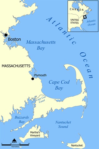
Cape Cod Bay is a large bay of the Atlantic Ocean adjacent to the U.S. state of Massachusetts. Measuring 604 square miles (1,560 km2) below a line drawn from Brant Rock in Marshfield to Race Point in Provincetown, Massachusetts, it is enclosed by Cape Cod to the south and east, and Plymouth County, Massachusetts, to the west. To the north of Cape Cod Bay lie Massachusetts Bay and the Atlantic Ocean. Cape Cod Bay is the southernmost extremity of the Gulf of Maine. Cape Cod Bay is one of the bays adjacent to Massachusetts that give it the name Bay State. The others are Narragansett Bay, Buzzards Bay, and Massachusetts Bay.
Border Lake Provincial Park is a provincial park in British Columbia, Canada, located on the right (west) bank of the Unuk River and extending from that river's crossing of the Canada–United States border upstream.

Route 39 is a 8.15-mile-long (13.12 km) southwest-northeast route through the towns of Harwich, Brewster and Orleans, on Cape Cod, Massachusetts. It begins and ends at Route 28, acting as a bypass route for those not wishing to follow 28 through Harwich Port and Chatham.
Pleasant Bay is a bay of the Atlantic Ocean just north of the "elbow" of Cape Cod in Massachusetts. It is bounded on the east by a long peninsula and a barrier island, and harbors 7,825 acres (31.67 km2) of saltwater when the tide is in.
West Plymouth is a village in Plymouth, Plymouth County, Massachusetts, United States. It is located beyond the Colony Place retail development and the Plymouth Industrial Park off U.S. Route 44 and north of Myles Standish State Forest. It stretches west to the Carver town line and north to the Kingston town line. The villages within this section include Micajah Heights, a community surrounding Micajah Pond, Billington Sea, a village along the southern shore of the pond, Darby, a village surrounding Darby Pond, and the portion of East Carver that extends into Plymouth.

Vallerville, also called Vallersville, is a village in Plymouth, Massachusetts, United States, the smallest village in the town. It is located south of the village of Manomet and north of the village of Ellisville. The neighborhoods of Ocean Aire Beach, Surfside Beach and Bayside Beach are located within Vallerville.
Harwich High School was a public high school located in Harwich, Massachusetts, United States. Harwich High School was the third smallest public high school on Cape Cod. Harwich High School closed in 2013-2014 due to the towns of Harwich and Chatham deciding to regionalize their school districts and build a regional high school. The new high school is Monomoy Regional High School, which opened in 2014.
Chatham High School was a public high school located in Chatham, Massachusetts. Chatham served roughly 250 students in grades 9–12. Chatham's mascot was the Blue Devils and the school's colors were Royal Blue and White. In September 2014, Chatham merged with Harwich High School of Harwich to become the new Monomoy Regional High School.

North Bridgton is a village in the town of Bridgton in Cumberland County, Maine, United States. It is located just west of Long Lake, and just south of the town of Harrison. In 1768, the undeveloped land was granted by the Massachusetts General Court to a group of proprietors led by a man named Moody Bridges. Settlement began in 1770, when a tavern was built.
West Harwich is a village in the town of Harwich, Massachusetts, on Cape Cod, United States. West Harwich makes most of the population in the Northwest Harwich Census-designated place.

This is a list of roundabouts in the state of Massachusetts in the United States. Intersections that are called traffic circles or roundabouts in the rest of the US are referred to as "rotaries" in Massachusetts, as well as other parts of New England including parts of Connecticut, New Hampshire, Maine Rhode Island, & Vermont.