
Cape Cod is a hook-shaped peninsula extending into the Atlantic Ocean from the southeastern corner of mainland Massachusetts, in the northeastern United States. Its historic, maritime character and ample beaches attract heavy tourism during the summer months. The name Cape Cod, coined in 1602 by Bartholomew Gosnold, is the ninth oldest English place-name in the U.S.

Wellfleet is a town in Barnstable County, Massachusetts, United States, and is located halfway between the "tip" and "elbow" of Cape Cod. The town had a population of 3,566 at the 2020 census, which swells nearly sixfold during the summer. A total of 70% of the town's land area is under protection, and nearly half of it is part of the Cape Cod National Seashore. Wellfleet is famous for its oysters, which are celebrated in the annual October Wellfleet OysterFest.

Mashpee is a town in Barnstable County, Massachusetts, United States, on Cape Cod. The population was 15,060 as of 2020. The town is the site of the headquarters and most members of the Mashpee Wampanoag Tribe, one of two federally recognized Wampanoag groups.

Bourne is a town in Barnstable County, Massachusetts, United States. The population was 20,452 at the 2020 census.

Brewster is a town in Barnstable County, Massachusetts, United States, Barnstable County being coextensive with Cape Cod. The population of Brewster was 10,318 at the 2020 census.

Chatham is a town in Barnstable County, Massachusetts, United States. Chatham is located at the southeast tip of Cape Cod and has historically been a fishing community. First settled by the English in 1664, the township was originally called Monomoit based on the indigenous population's term for the region. Chatham was incorporated as a town on June 11, 1712, and has become a summer resort area. The population was 6,594 at the 2020 census, and can swell to 25,000 during the summer months. There are four villages that comprise the town, those being Chatham (CDC), South Chatham, North Chatham, and West Chatham. Chatham is home to the Monomoy National Wildlife Refuge, and the decommissioned Monomoy Point Light both located on Monomoy Island. A popular attraction is the Chatham Light, which is an operational lighthouse that is operated by the United States Coast Guard.
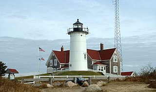
Falmouth is a town in Barnstable County, Massachusetts, United States. The population was 32,517 at the 2020 census, making Falmouth the second-largest municipality on Cape Cod after Barnstable. The terminal for the Steamship Authority ferries to Martha's Vineyard is located in the village of Woods Hole in Falmouth. Woods Hole also contains several scientific organizations such as the Woods Hole Oceanographic Institution (WHOI), the Marine Biological Laboratory (MBL), the Woodwell Climate Research Center, NOAA's Woods Hole Science Aquarium, and the scientific institutions' various museums.

Sandwich is a town in Barnstable County, Massachusetts, United States, and is the oldest town on Cape Cod. The town motto is Post tot Naufracia Portus, "after so many shipwrecks, a haven". The population was 20,259 at the 2020 census.

Dennis is a town in Barnstable County, Massachusetts, United States, located near the center of Cape Cod. The population was 14,674 at the 2020 census.

Cotuit is one of the villages of the Town of Barnstable on Cape Cod in Barnstable County, Massachusetts, United States. Located on a peninsula on the south side of Barnstable about midway between Falmouth and Hyannis, Cotuit is bounded by the Santuit River to the west on the Mashpee town line, the villages of Marstons Mills to the north and Osterville to the east, and Nantucket Sound to the south. Cotuit is primarily residential with several small beaches including Ropes Beach, Riley's Beach, The Loop Beach and Oregon Beach.
Barnstable is the name of one of the seven villages within the Town of Barnstable, Massachusetts. The Village of Barnstable is located on the north side of the town, centered along "Old King's Highway", and houses the County Complex of Barnstable County, a small business district, a working harbor, and several small beaches. The village is home to many small attractions, including Sturgis Library, the Olde Colonial Courthouse, the Barnstable Comedy Club, and the Trayser Museum.

Cape Cod Airfield, in Marstons Mills, Massachusetts is a public airport owned by the Town of Barnstable.

Marstons Mills is a village in the town of Barnstable, Massachusetts, United States. It is primarily residential, located on Massachusetts Route 28, and rural in nature. Main roads also include Massachusetts Route 149, Race Lane, River Road, Osterville-West Barnstable Road, and Santuit-Newtown Road.

West Barnstable station is a railway station in West Barnstable, Massachusetts. The train station currently serves as a weekend stop for several excursion trains operated by the Cape Cod Central Railroad. The station building, which is owned by the Town of Barnstable, Massachusetts, is the headquarters on the Cape Cod Chapter of the National Railway Historical Society (NRHS).

Camp Edwards is a United States military training installation which is located in western Cape Cod in Barnstable County, Massachusetts. Originally the Massachusetts Military Reservation acquired in September 1935, in 1938 it was named after Major General Clarence Edwards, commander of the 26th Division in World War I. It is home to the 3rd Battalion, 126th Aviation Regiment.
The West Barnstable Village–Meetinghouse Way Historic District is a historic district on Meetinghouse Way from County Rd. to Meetinghouse Road in Barnstable, Massachusetts. The 175-acre (71 ha) district encompasses the historic heart of the village of West Barnstable. This is a roughly linear district, including all of the properties along Meetinghouse Way between County Road and the 1717 West Parish Meetinghouse, which is the district's most prominent building. Most of the houses in the district were built in the 18th and early 19th centuries, and are thus predominantly in Georgian, Federal, and Greek Revival styles. Later buildings include the First Selectmen's Office (1889), elementary school (1903), and railroad station (1910).
New Silver Beach is a beach and village of the same name. It is primarily a summer colony and is the largest settlement at Wild Harbor, a natural bay on the north shore of Buzzards Bay.

Barnstable is a town in the U.S. state of Massachusetts and the county seat of Barnstable County. Barnstable is the largest community, both in land area and population, on Cape Cod, and is one of thirteen Massachusetts municipalities that have been granted city forms of government by the Commonwealth of Massachusetts but wish to retain "the town of" in their official names. At the 2020 census it had a population of 48,916. The town contains several villages within its boundaries. Its largest village, Hyannis, is the central business district of the county and home to Barnstable Municipal Airport, the airline hub of Cape Cod and the islands of Martha's Vineyard and Nantucket. Additionally, Barnstable is a 2007 winner of the All-America City Award.
Camp Perkins was a Massachusetts Army National Guard camp located in Barnstable, Massachusetts near the site of the present Cape Cod Airfield.


