Sagamore Beach, Massachusetts

Last updated
Sagamore Beach, Massachusetts
Village
Beach, Sagamore Beach MA.jpg
Sagamore Beach
USA Mass Cape Cod location map.svg
Red pog.svg
Sagamore Beach
Coordinates: 41°47′N70°32′W / 41.79°N 70.53°W / 41.79; -70.53
Country United States
State Massachusetts
County Barnstable
Town Bourne, MA
Permanent settlers [1] 1637
Post Office Opened [2] 1906
Area
  Land3.36 sq mi (8.7 km2)
Elevation
[3]
62 ft (19 m)
Population
 (2021 [4] )
  Total4,229
  Density1,260/sq mi (490/km2)
Time zone UTC-5 (Eastern (EST))
  Summer (DST) UTC-4 (EDT)
ZIP codes
02561, 02562
Area code(s) 508, 774
FIPS code 25-59000
GNIS feature ID616333 [3]
Website Barnstable County Website

Sagamore Beach is a village on Cape Cod, in the town of Bourne, Massachusetts, United States. The northern half of the Sagamore census-designated place, Sagamore Beach faces Cape Cod Bay, and the Cape Cod Canal courses through it. Along with Buzzards Bay and Bournedale, it is one of three communities that comprise the county of Barnstable.

Contents

In addition to its residential areas, Sagamore Beach has a small commercial district located near the Sagamore Bridge and along Massachusetts Route 3A, [1] which passes through the bridge. It also adjoins the Scusset Beach State Reservation, a public-access, beachfront recreation site located at the northern end of Cape Cod Canal.

Developments in the 2000s included a new post office, a fire station, and the creation of several new subdivisions. In December 2023, the federal government awarded an initial down payment of $372 million in grants for the renovation of the Sagamore and Bourne Bridges, both of which are nearing their obsolescence. [5] The two bridges connect Cape Cod to Massachusetts proper, arching over the canal and allowing the passage of pedestrian and vehicular traffic. [6]

History

In 1620, the colonial ship Mayflower from Britain landed in what is now modern Plymouth, north of Sagamore Beach. Roughly 30 Native American tribes were in what is now the southeastern Massachusetts area, with the Wampanoag tribe among them being the most populous. [7] [1] A heavily trodden trail used by native tribes to reach the eastern reaches of Cape Cod in the 17th century crossed the region. The European settlers, making the perilous journey across the Atlantic Ocean, permanently settled the area in the year 1637, gradually increasing in numbers during the succeeding decades. The trail, later widened by settlers, became the main transportation artery to Cape Cod. What is now the state road of Massachusetts Route 6A roughly follows the trail's historical route. [1] The names of numerous streets and roads in Sagamore pay homage to the indigenous peoples who had dwelt upon the land. Some examples of the names include Tecumseh, Siasconset, Sachem, Scusset, Manomet, Indian Trail, Indian Hill, and Fox Run. Both the names sagamore and sachem are descended from Native American titles. [1]

Initially a village, Sandwich of Massachusetts was divided to create the town of Bourne in 1884. After the dredging for the Cape Cod Canal project was started in 1884, Sagamore Beach became the center of commerce for the town. [1] The population significantly increased in 1905 when the Christian Endeavor Society, a Christianity promoting group, founded a summer colony in the region, and some of the Victorian homes built by the colony still line the bluffs along the coastline. [1] [8] The Sagamore Beach Colony Club, established in 1909, aims to continue the traditions and lifestyle of locals and serves as a vital community resource today. [9]

Demographics

The village of Sagamore Beach is primarily a residential area. As of 2021, it had a resident population of 4.23 thousand people, an 11.5% year-on-year increase compared to 2020. Its median household income was $106,917 USD, 51% higher than the national median, and 20% higher than the state median ($89,026 USD). The median age for its residents stood at 37.8 years, and has been steadily decreasing in recent years owing to the inflow of young settlers. The homeownership rate was 81.2% in 2021, with the median property value being around $433,000 USD. [4]

Sagamore Beach's demography is mostly composed of white people, with 81.3% of its residential population falling into this category. Hispanics, Asians, and African Americans make up most of the rest. 96.5% of its population are US citizens, with all households surveyed reporting English to be their primary shared language in 2021. The three largest industries in Sagamore are Retail, Health Care & Social Assistance, and Construction, with 363, 321, and 215 workers, respectively. A total of ~2.42 thousand people were employed in 2021, or about 57% of its populace. [4]

Politics

The village is located in Massachusetts's 9th congressional district, represented by Democrat William R. Keating in the House of Representatives since 2013. [10] Sagamore Beach comprises ~0.5% of the district's population.

See also

Related Research Articles

<span class="mw-page-title-main">Cape Cod</span> Cape in the northeastern United States

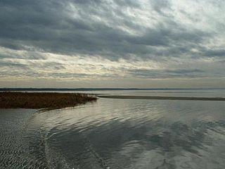
Cape Cod is an arm-shaped peninsula extending into the Atlantic Ocean from the southeastern corner of Massachusetts, in the northeastern United States. Its historic, maritime character and ample beaches attract heavy tourism during the summer months. The name Cape Cod, coined in 1602 by Bartholomew Gosnold, is the ninth oldest English place-name in the U.S.

<span class="mw-page-title-main">Cape Cod Canal</span> Waterway in Massachusetts

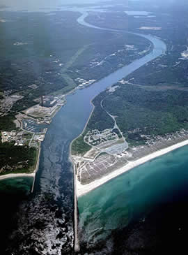
The Cape Cod Canal is an artificial waterway in Massachusetts connecting Cape Cod Bay in the north to Buzzards Bay in the south, and is part of the Atlantic Intracoastal Waterway. The approximately 17.4-mile (28.0 km) long canal traverses the neck of land joining Cape Cod to the state's mainland. It mostly follows tidal rivers widened to 480 feet (150 m) and deepened to 32 feet (9.8 m) at mean low water, shaving up to 135 miles (217 km) off the journey around the Cape for its approximately 14,000 annual users.

<span class="mw-page-title-main">Barnstable County, Massachusetts</span> County in Massachusetts, United States

Barnstable County is a county located in the U.S. state of Massachusetts. At the 2020 census, the population was 228,996. Its county seat is Barnstable. The county consists of Cape Cod and associated islands.

<span class="mw-page-title-main">Eastham, Massachusetts</span> Town in Massachusetts, United States

Eastham is a town in Barnstable County, Massachusetts, United States, Barnstable County being coextensive with Cape Cod. The population was 5,752 at the 2020 census.

<span class="mw-page-title-main">Mashpee, Massachusetts</span> Town in Massachusetts, United States

Mashpee is a town in Barnstable County, Massachusetts, United States, on Cape Cod. The population was 15,060 as of 2020. The town is the site of the headquarters and most members of the Mashpee Wampanoag Tribe, one of two federally recognized Wampanoag groups.

<span class="mw-page-title-main">Sagamore, Massachusetts</span> Census-designated place in Massachusetts, United States

Sagamore is a census-designated place (CDP) in the town of Bourne in Barnstable County, Massachusetts, United States. The population was 3,623 at the 2010 census. "Sagamore" was one of the words used by northeastern Native Americans to designate an elected chief or leader.

<span class="mw-page-title-main">Bourne, Massachusetts</span> Town in Massachusetts, United States

Bourne is a town in Barnstable County, Massachusetts, United States. The population was 20,452 at the 2020 census.

<span class="mw-page-title-main">Brewster, Massachusetts</span> Town in Massachusetts, United States

Brewster is a town in Barnstable County, Massachusetts, United States, Barnstable County being coextensive with Cape Cod. The population of Brewster was 10,318 at the 2020 census.

<span class="mw-page-title-main">Chatham, Massachusetts</span> Town in Massachusetts, United States

Chatham is a town in Barnstable County, Massachusetts, United States. Chatham is located at the southeast tip of Cape Cod and has historically been a fishing community. First settled by the English in 1664, the township was originally called Monomoit based on the indigenous population's term for the region. Chatham was incorporated as a town on June 11, 1712, and has become a summer resort area. The population was 6,594 at the 2020 census, and can swell to 25,000 during the summer months. There are four villages that comprise the town, those being Chatham (CDP), South Chatham, North Chatham, and West Chatham. Chatham is home to the Monomoy National Wildlife Refuge, and the decommissioned Monomoy Point Light both located on Monomoy Island. A popular attraction is the Chatham Light, which is an operational lighthouse that is operated by the United States Coast Guard.

<span class="mw-page-title-main">Falmouth, Massachusetts</span> Town in Massachusetts, United States

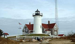
Falmouth is a town in Barnstable County, Massachusetts, United States. The population was 32,517 at the 2020 census, making Falmouth the second-largest municipality on Cape Cod after Barnstable. The terminal for the Steamship Authority ferries to Martha's Vineyard is located in the village of Woods Hole in Falmouth. Woods Hole also contains several scientific organizations such as the Woods Hole Oceanographic Institution (WHOI), the Marine Biological Laboratory (MBL), the Woodwell Climate Research Center, NOAA's Woods Hole Science Aquarium, and the scientific institutions' various museums.

<span class="mw-page-title-main">Sandwich, Massachusetts</span> Town in Massachusetts, United States

Sandwich is a town in Barnstable County, Massachusetts and is the oldest town on Cape Cod. The town motto is Post tot Naufracia Portus, "after so many shipwrecks, a haven". The population was 20,259 at the 2020 census.

<span class="mw-page-title-main">Dennis, Massachusetts</span> Town in Massachusetts, United States

Dennis is a town in Barnstable County, Massachusetts, United States, located near the center of Cape Cod. The population was 14,674 at the 2020 census.

<span class="mw-page-title-main">Massachusetts Route 25</span> Highway in Massachusetts

Route 25 is a 10-mile-long (16 km) freeway located in Plymouth County and Barnstable County, Massachusetts, United States. The route is a nominally east–west highway, and less commonly known as the Blue Star Memorial Highway. An eastward continuation of Interstate 495, Route 25 provides freeway access to Cape Cod. The route's western terminus is at a trumpet interchange with I-495 and I-195 in West Wareham. The route has three numbered interchanges along its length before terminating at the northern end of the Bourne Bridge in Bourne; the mainline of Route 25 continues across the bridge and over the Cape Cod Canal as Massachusetts Route 28 south.

<span class="mw-page-title-main">Cape Cod Railroad</span> Railroad in southeastern Massachusetts, US

The Cape Cod Railroad is a railroad in southeastern Massachusetts, running from Pilgrim Junction in Middleborough across the Cape Cod Canal Railroad Bridge, where it splits towards Hyannis in one direction and Falmouth in the other. It was incorporated in 1846 as the Cape Cod Branch Railroad to provide a rail link from the Fall River Railroad line in Middleborough to Cape Cod.

The Sagamore Bridge in Sagamore, Massachusetts carries Route 6 and the Claire Saltonstall Bikeway across the Cape Cod Canal, connecting Cape Cod with the mainland of Massachusetts. It is the more northeastern of two automobile canal crossings, the other being the Bourne Bridge. Most traffic approaching from the north follows Massachusetts Route 3 which ends at Route 6 just north of the bridge, and the bridge provides direct expressway connections from Boston and Interstate 93.

Sagamore may refer to:

<span class="mw-page-title-main">Bourne Braves</span> Collegiate summer baseball team in Massachusetts

The Bourne Braves are a collegiate summer baseball team based in Bourne, Massachusetts. The team is a member of the Cape Cod Baseball League (CCBL) and plays in the league's West Division. The Braves play their home games at Doran Park on the campus of Upper Cape Cod Regional Technical School in Bourne. The Braves are owned and operated by the non-profit Bourne Athletic Association.

<span class="mw-page-title-main">Claire Saltonstall Bikeway</span>

The Claire Saltonstall Bikeway, also known as the Boston to Cape Cod Bikeway, is a 135-mile bikeway marked as Bike Route 1 that starts on the Charles River Bike Path near Boston University in Boston, Massachusetts and winds along Boston's Emerald Necklace, using mostly back roads and bike paths with occasional stretches of secondary highways. It ends in Provincetown, Massachusetts. The bikeway was named on July 17, 1978, in memory of Claire Saltonstall, the daughter of Senator William L. Saltonstall. Claire was killed by an automobile in 1974 while she was riding her bicycle. Senator Saltonstall was a sponsor of bicycle safety legislation and was instrumental in developing the bikeway. Dual signs were erected along the route shortly after the bikeway opened, one with a picture of a bicycle in a green background and the green number 1 below the picture, and another rectangular sign with the words Claire Saltonstall Bikeway below that. Few of the original signs survive today, however, and new signs were erected in the summer of 2018.

<span class="mw-page-title-main">Scusset Beach State Reservation</span>

Scusset Beach State Reservation is a state-operated, public recreation area located in the town of Sandwich in Barnstable County, Massachusetts, at the east end of the Cape Cod Canal on land formerly part of Sagamore Hill Military Reservation. In addition to its beach and campgrounds, prominent features of the park include Sagamore Hill, a one-time Native American meeting ground and site of World War II coastal fortifications, and a 3,000-foot (910 m) stone jetty that separates the canal and beach. Unlike most of Sandwich, this section of the town is on the mainland side of the Cape Cod Canal. The state park is managed by the Massachusetts Department of Conservation and Recreation under a lease agreement with the U.S. Army Corps of Engineers.

<span class="mw-page-title-main">Bournedale, Massachusetts</span> Village in Massachusetts, United States

Bournedale is a village in the town of Bourne in Barnstable County, Massachusetts fronting Sagamore Beach, Buzzards Bay and the middle of the Cape Cod Canal. Along with Buzzards Bay and Sagamore Beach, it is one of only three communities in Barnstable County that are north of the Cape Cod Canal.

References

  1. 1 2 3 4 5 6 7 "Club History - Sagamore Beach Colony Club". 2024-01-05. Archived from the original on 2024-01-05. Retrieved 2024-01-05.
  2. "Sagamore Beach (Barnstable County, MA)". 2024-01-05. Archived from the original on 2024-01-05. Retrieved 2024-01-05.
  3. 1 2 "Sagamore Beach". Geographic Names Information System . United States Geological Survey, United States Department of the Interior . Retrieved 2012-05-31.
  4. 1 2 3 "Sagamore, MA | Data USA". 2024-01-05. Archived from the original on 2024-01-05. Retrieved 2024-01-05.
  5. "Cape Cod bridge replacement gets $372M 'down payment' from DOT". 2024-01-05. Archived from the original on 2024-01-05. Retrieved 2024-01-05.
  6. "Cape Bridges | Mass.gov". 2024-01-05. Archived from the original on 2024-01-05. Retrieved 2024-01-05.
  7. Bonfanti, Leo (1968). Biographies and Legends of the New England Indians. Wakefield, MA: Pride Publications.
  8. Vuilleumier, Marion R. (2003). Sagamore Beach. Arcadia Publishing. pp. 15–16. ISBN   0-7385-1183-8.
  9. Box 417, Sagamore Beach Colony Club P. O.; Beach, Sagamore (2014-03-17). "Home". Sagamore Beach Colony Club. Retrieved 2024-01-05.{{cite web}}: CS1 maint: numeric names: authors list (link)
  10. "Congressman Bill Keating". Congressman Bill Keating. Retrieved 2024-01-05.