List of pedestrian zones

Last updated

Venice has a pedestrian zone covering c. 726.8 ha out of c. 798 ha (c. 91%) of its historic city centre. Dorsoduro, 30100 Venezia, Italy - panoramio (480).jpg
Venice has a pedestrian zone covering c. 726.8 ha out of c. 798 ha (c. 91%) of its historic city centre.

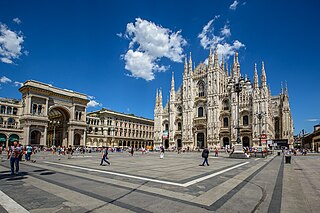
This is a list of pedestrian zones: urban streets where vehicle traffic has been restricted or eliminated for pedestrian use only. [4] These are usually pedestrianised urban centres of a city, town or district with a residential population that have been retrofitted. [5]

CountryLocationDetails
Armenia Yerevan Northern Avenue, located in the Kentron district of central Yerevan, is a large pedestrian avenue. The avenue was inaugurated in 2007 and is mainly home to residential buildings, offices, luxury shops and restaurants. [6]
Australia Melbourne Several areas within the Melbourne CBD, [7] including the Bourke Street Mall, Swanston Street, [8] Block Arcade, Royal Arcade, Degraves Street, Queen Victoria Village, City Square and Federation Square
Australia Perth Hay Street in the Perth CBD became the first pedestrianised street of any Australian major capital in 1972 [9]
Australia Sydney Within the Sydney CBD, George Street was pedestrianised between Bridge Street and Hay Street in stages between 2021 and 2023 [10] [11]
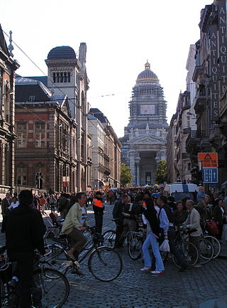
Belgium Brussels Europe's largest pedestrian zone (French: Le Piétonnier), established in phases starting in 2015 and set to cover 50 hectares (120 acres). The area covers much of the historic centre within the Small Ring (the ring road built on the site of the 14th century walls), including the Grand-Place, the Place de Brouckère/De Brouckèreplein, the Boulevard Anspach/Anspachlaan, and the Place de la Bourse/Beursplein. [12] [13]
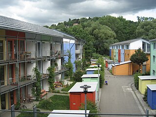
Germany Freiburg im Breisgau Large car-free centre (610 x 720 m). Medieval university town. Minimal car traffic is permitted on some streets. Trams provide access. Progressively pedestrianised since 1971. [14]
The neighbourhood of Vauban is considered the prototype for the Vauban model of transport planning. Some streets are "parking-space-free" (German : stellplatzfrei, rather than "car-free". [15]
Germany Munich The Kaufingerstraße and Neuhauser Straße through the historic city center from Marienplatz to Stachus were pedestrianized on June 30, 1972 in time for the 1972 Summer Olympics. [16] In 2019, the Sendlinger Straße was pedestrianized from Marienplatz to Sendlinger Tor. [17]
Italy Venice The historic centre (Italian : centro storico) of Venice is divided in six sestieri ("districts") with a combined area of 7.9796 km2 (797.9631 ha; 7,979,631 m2). [1] Of its 129 islands, [2] Tronchetto, Santa Chiara (which contains the Port of Venice) and the Piazzale Roma bus station square in the Santa Croce sestiere are the only islands where automobiles and busses are permitted within the historic centre; [3] these three jointly cover 711,339 m2 (71.1339 ha; 0.711339 km2). [2] The rest of the Venetian Inner Islands are a pedestrian zone covering 7.268261 km2 (726.8261 ha; 7,268,261 m2; c. 91% of the historic centre), [1] [2] where transport takes place on foot or by water (gondola). [3]
Kazakhstan Almaty The Arbat, one of Kazakhstan's most popular and first pedestrian zones in Almaty, was established in Jibek Joly Street in the late 1980s. The area is lined with many shops and kiosks, as well as local artists selling their work. [18]
Morocco Fez Fes el Bali, the larger of the two medieval medinas, consists of narrow streets that are inaccessible by automobile. A few access streets for emergency vehicles are being built. [19] [ self-published source? ]
Morocco Marrakesh The historic souks (marketplaces) in the city centre are a car-free zone. The streets are only narrow enough for pedestrians, cyclists or motorcyclists. The surrounding medina was designated a UNESCO World Heritage Site in 1985. [20]
Netherlands Arnhem The pedestrian zone (Dutch : voetgangersgebied) covers the area within the boundaries of the following streets and squares: Nieuwe Plein, Willemsplein, Gele Rijdersplein, Looierstraat, Velperbinnensingel, Koningsplein, St. Catharinaplaats, Beekstraat, Walburgstraat, Turfstraat, Kleine Oord, and Nieuwe Oeverstraat. [21]
Netherlands Utrecht The pedestrian zone gradually grew over the years. As of 1 August 2022, it covers the following streets and squares: Lijnmarkt, Choorstraat, Oudegracht Westzijde until Lange Viestraat, Boterstraat, Steenweg, Lange and Korte Elisabethstraat, Vredenburg, Donkerstraat, Mariastraat, Achter and Voor Clarenburg, Zakkendragerssteeg, Drieharingstraat, Hamsteeg, Bakkerstraat, Lauwersteeg, Hekelsteeg, Massegast, Vinkenburgstraat, Neude, Schoutenstraat, Oudegracht Oostzijde from Hamburgerbrug, Lichte en Donkere Gaard, Vismarkt, Stadhuisbrug, Ganzenmarkt, Wed, Oudegracht Oostzijde until Potterstraat, Drakenburgstraat, Servetstraat, Zadelstraat, Buurkerkhof, Hollandse Toren, Vlaamse Toren, Vredenburgkade, Rijnkade. [22]

See also

Related Research Articles

<span class="mw-page-title-main">Houten</span> Municipality in Utrecht, Netherlands

Houten is a municipality in the Netherlands, in the province of Utrecht.

<span class="mw-page-title-main">Street reclamation</span> Changing streets to focus on non-car use

Street reclaiming is the process of converting, or otherwise returning streets to a stronger focus on non-car use — such as walking, cycling and active street life. It is advocated by many urban planners and urban economists, of widely varying political points of view. Its primary benefits are thought to be:

<span class="mw-page-title-main">Car-free days</span> Day promoting car-free travel

On car-free days, people are encouraged to travel by means other than cars. Some cities, like Jakarta and Tehran, have weekly car-free days. Other such days are annual. World Car Free Day is celebrated on September 22. Organized events are held in some cities and countries.

<span class="mw-page-title-main">Pedestrian zone</span> Urban car-free area reserved for pedestrian use

Pedestrian zones are areas of a city or town restricted to use by people on foot or human-powered transport such as bicycles, with non-emergency motor traffic not allowed. Converting a street or an area to pedestrian-only use is called pedestrianisation.

<span class="mw-page-title-main">Car-free movement</span> Movement to reduce the use of private vehicles

The car-free movement is a broad, informal, emergent network of individuals and organizations, including social activists, urban planners, transportation engineers, environmentalists and others, brought together by a shared belief that large and/or high-speed motorized vehicles are too dominant in most modern cities. The goal of the movement is to create places where motorized vehicle use is greatly reduced or eliminated, by converting road and parking space to other public uses and rebuilding compact urban environments where most destinations are within easy reach by other means, including walking, cycling, public transport, personal transporters, and mobility as a service.

<span class="mw-page-title-main">Living street</span> Traffic calming in spaces shared between road users

A living street is a street designed with the interests of pedestrians and cyclists in mind by providing enriching and experiential spaces. Living streets also act as social spaces, allowing children to play and encouraging social interactions on a human scale, safely and legally. Living streets consider all pedestrians granting equal access to elders and those who are disabled. These roads are still available for use by motor vehicles; however, their design aims to reduce both the speed and dominance of motorized transport. The reduction of motor vehicle dominance creates more opportunities for public transportation. Living Streets achieve these strategies by implementing the shared space approach. Reducing demarcations between vehicle traffic and pedestrians create a cohesive space without segregating different modes of transportation. Vehicle parking may also be restricted to designated bays. These street design principles first became popularized in the Netherlands during the 1970s, and the Dutch word woonerf is often used as a synonym for living street.

<span class="mw-page-title-main">Ciclovía</span> Open-streets events in Colombia and beyond

Ciclovía, also ciclovia or cyclovia, is a Spanish term that means "cycleway", either a permanent bike path or the temporary closing of certain streets to automobiles for cyclists and pedestrians, a practice sometimes called open streets.

<span class="mw-page-title-main">Carfree city</span> Urban area absent of motor vehicles

A carfree city is an urban area absent of motor vehicles. Carfree cities rely on public transport, walking, and cycling for travel as opposed to motor vehicles. Districts where motor vehicles are prohibited are referred to as carfree zones. Carfree city models have gained traction in the second half of the 20th century due to issues with congestion and infrastructure, and proposed environmental and quality of life benefits. Many cities in Asia, Europe, and Africa have carfree areas due to the cities being created before the invention of motor vehicles, while many developing cities in Asia are using the carfree model to modernize their infrastructure.

A low-emission zone (LEZ) is a defined area where access by some polluting vehicles is restricted or deterred with the aim of improving air quality. This may favour vehicles such as bicycles, micromobility vehicles, (certain) alternative fuel vehicles, hybrid electric vehicles, plug-in hybrids, and zero-emission vehicles such as all-electric vehicles.

<span class="mw-page-title-main">Car dependency</span> Concept that city layouts favor automobiles over other modes of transportation

Car dependency is the concept that some city layouts cause cars to be favoured over alternate forms of transportation, such as bicycles, public transit, and walking.

<span class="mw-page-title-main">Midtbyen, Aarhus</span> Neighborhood in Aarhus Municipality, Central Denmark Region, Kingdom of Denmark

Midtbyen, also known as Aarhus Center or City, is the inner part of Aarhus. Midtbyen is part of district Aarhus C, mainly with postal code 8000, together with Vesterbro, Nørre Stenbro Trøjborg and Frederiksbjerg and has a population of around 90000

<span class="mw-page-title-main">Pedestrian village</span> Urban planning for mixed-use areas prioritising pedestrians

A pedestrian village is a compact, pedestrian-oriented neighborhood or town with a mixed-use village center. Shared-use lanes for pedestrians and those using bicycles, Segways, wheelchairs, and other small rolling conveyances that do not use internal combustion engines. Generally, these lanes are in front of the houses and businesses, and streets for motor vehicles are always at the rear. Some pedestrian villages might be nearly car-free with cars either hidden below the buildings, or on the boundary of the village. Venice, Italy is essentially a pedestrian village with canals. Other examples of a pedestrian village include Giethoorn village located in the Dutch province of Overijssel, Netherlands, Mont-Tremblant Pedestrian Village located beside Mont-Tremblant, Quebec, Canada, and Culdesac Tempe in Tempe, Arizona.

<span class="mw-page-title-main">Transit mall</span> Urban street reserved for public transit, bicycles, and pedestrians

A transit mall is a street, or set of streets, in a city or town along which automobile traffic is prohibited or greatly restricted and only public transit vehicles, bicycles, and pedestrians, and emergency services are permitted.

<span class="mw-page-title-main">Vauban, Freiburg</span>

Vauban is a neighbourhood (Stadtteil) to the south of the town centre in Freiburg, Germany. It was built as "a sustainable model district" on the site of a former French military base named after Sébastien Le Prestre de Vauban, the 17th century French Marshal who built fortifications in Freiburg while the region was under French rule. Construction began in 1998, and the first two residents arrived in 2001.

<span class="mw-page-title-main">Zone 1 of Milan</span> Municipality of Milan in Lombardy, Italy

The Zone 1 of Milan, since 2016 officially Municipality 1 of Milan, is one of the 9 administrative divisions of Milan, Italy.

A circulation plan is a schematic empirical projection/model of how people and/or vehicles flow through a given area.

<span class="mw-page-title-main">Milan Area C</span> Congestion charge in the city center of Milan, Italy

Area C is a congestion charge active in the city center of Milan, Italy. It was introduced in 2012, replacing the previous pollution charge Ecopass and based on the same designated traffic restricted zone. The area is about 8.2 km2 (3.2 sq mi) with 77,000 residents and is accessible through gates monitored by traffic cameras.

<span class="mw-page-title-main">Shared-use path</span> Pathway for pedestrians and cyclists

A shared-use path, mixed-use path or multi-use pathway is a path which is "designed to accommodate the movement of pedestrians and cyclists". Examples of shared-use paths include sidewalks designated as shared-use, bridleways and rail trails. A shared-use path typically has a surface that is asphalt, concrete or firmly packed crushed aggregate. Shared-use paths differ from cycle tracks and cycle paths in that shared-use paths are designed to include pedestrians even if the primary anticipated users are cyclists.

<span class="mw-page-title-main">Limited traffic zone</span>

Limited traffic zone (LTZ) is type of restricted traffic area found in many historic European city centres where non-residents and unauthorized vehicles are prohibited from driving at certain times. These areas are relatively abundant in Italy, where they are called zona a traffico limitato (ZTL), but they also exist in Spain, Portugal, France and Poland with different names. Around 350 Italian cities have LTZs, and 250 have low-emission zones (LEZs), usually enforced with camera surveillance. They help protect historic city centres from excessive traffic, which would otherwise make the city less attractive. They can also be aimed at limiting pollution levels or at increasing administrative revenue by paying an urban toll.

References

  1. 1 2 3 "Superficie territoriale del Comune di Venezia in ettari ha) in kilometri quadrati (kmq) e in metri quadrati (mq)" (PDF). comune.venezia.it. Retrieved 29 December 2022.
  2. 1 2 3 4 Franco Fiorin (2018). "Aggiornamento del piano di eliminazione delle barriere architettoniche per Venezia centro storico e isole – sezione centro storico" (PDF). comune.venezia.it. Retrieved 29 December 2022.
  3. 1 2 3 Hardy, Paula; Di Duca, Marc; Dragicevich, Peter (2018). Lonely Planet Venice & the Venet. Lonely Planet. p. 529. ISBN   9781787012455 . Retrieved 29 December 2022.
  4. Castillo-Manzano, José; Lourdes Lopez-Valpuesta; Juan P. Asencio-Flores (2014). "Extending pedestrianization processes outside the old city center; conflict and benefits in the case of the city of Seville". Habitat International. 44: 194–201. doi:10.1016/j.habitatint.2014.06.005. hdl: 11441/148812 . As part of this rising concern we can highlight a scheme that has acquired great importance in processes to redesign cities, pedestrianization. Pedestrianization can be defined as restricting or eliminating [vehicle] traffic in a street or streets for the use of pedestrians only (Hass-Klau, 1993). A differentiation should be made between pedestrianization processes and traffic calming, defined as the application of measures such as road humps, tree planting or speed cushions to impress upon the driver that the street is primarily for shopping or residential use (Slinn, Matthews, & Guest, 2005).
  5. Melia, Steve; Parkhurst, Graham; Barton, Hugh (August 2010). "Carfree, low-car – What's the Difference?" (PDF). World Transport Policy & Practice 16. Eco-Logica Ltd. 16 (2): 24–32. Archived from the original (PDF) on 1 June 2013. Retrieved 16 December 2022. Whereas the first two models apply to newly-built carfree developments, most pedestrianised city, town and district centres have been retro-fitted.
  6. "Yerevan Remade: The Case of the Northern Avenue" . Retrieved 8 February 2023.
  7. "Melbourne: A Pedestrian Paradise". Streetfilms.
  8. Dowling, Jason (26 January 2010). "No cars, new city squares: Doyle's Swanston Street reversal". The Age .
  9. "Document Library | Hay Street Mall - Public Realm Enhancement Concept Plan | Engage Perth".
  10. "George Street transformation takes shape". news.cityofsydney.nsw.gov.au. Retrieved 7 February 2023.
  11. George Street south transformed into a pedestrian boulevard City of Sydney
  12. "Project. Pedestrian Zone, Brussels city website". Archived from the original on 21 September 2020. Retrieved 2 July 2020.
  13. O'Sullivan, Feargus (1 May 2019). "In Car-Choked Brussels, the Pedestrians Are Winning". Bloomberg. Retrieved 2 July 2020.
  14. Monheim, R. (1997). "The Evolution from Pedestrian Areas to 'Car-free' City Centres in Germany". In Tolley, R. (ed.). The greening of urban transport : planning for walking and cycling in Western cities (2nd ed.). Chichester: Wiley. pp. 253–265.
  15. Melia, Parkhurst & Barton 2010, pp. 25–26.
  16. "10 spannende Fakten über Münchens Fußgängerzone". 15 October 2009. Retrieved 19 June 2023.
  17. "Sendlinger Straße: Infos zu den Sehenswürdigkeiten" . Retrieved 19 June 2023.
  18. "Алматинский и столичный Арбат: улицы с историей и точки притяжения в городе". weproject.media (in Russian). 15 June 2020. Retrieved 27 September 2023.
  19. carfree.com by J.H. Crawford
  20. carfree.com by J.H. Crawford
  21. "Verordening ontheffingen berijden voetgangersgebied binnenstad Arnhem 2004" [2004 Regulation on exemptions for driving in the pedestrian zone in the inner city of Arnhem]. repository.officiele-overheidspublicaties.nl (in Dutch). 2010. Retrieved 16 December 2022.
  22. Utrecht, Gemeente (10 March 2022). "Voetgangersgebied binnenstad | Gemeente Utrecht". utrecht.nl (in Dutch). Retrieved 17 December 2022.