Related Research Articles

The River Rother flows for 35 miles (56 km) through the English counties of East Sussex and Kent. Its source is near Rotherfield in East Sussex, and its mouth is on Rye Bay, part of the English Channel. Prior to 1287, its mouth was further to the east at New Romney, but it changed its course after a great storm blocked its exit to the sea. It was known as the Limen until the sixteenth century. For the final 14 miles (23 km), the river bed is below the high tide level, and Scots Float sluice is used to control levels. It prevents salt water entering the river system at high tides, and retains water in the river during the summer months to ensure the health of the surrounding marsh habitat. Below the sluice, the river is tidal for 3.7 miles (6.0 km).
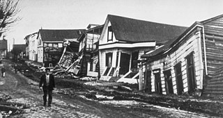
The 1960 Valdivia earthquake and tsunami or the Great Chilean earthquake on 22 May 1960 was the most powerful earthquake ever recorded. Various studies have placed it at 9.4–9.6 on the moment magnitude scale. It occurred in the afternoon, and lasted for approximately 10 minutes. The resulting tsunamis affected southern Chile, Hawaii, Japan, the Philippines, eastern New Zealand, southeast Australia, and the Aleutian Islands.

An arroyo, also called a wash, is a dry creek, stream bed or gulch that temporarily or seasonally fills and flows after sufficient rain. Flash floods are common in arroyos following thunderstorms.

The Biobío River is the second largest river in Chile. It originates from Icalma and Galletué lakes in the Andes and flows 380 km to the Gulf of Arauco on the Pacific Ocean.
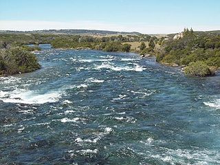
The Baker River is a river located in the Aysén del General Carlos Ibáñez del Campo Region of the Chilean Patagonia. It is Chile's largest river in terms of volume of water. The river flows out of Bertrand Lake, which is fed by General Carrera Lake. It runs along the east side of the Northern Patagonian Ice Field and empties into the Pacific Ocean, near the town of Caleta Tortel. The river forms a delta, dividing into two major arms, of which only the northernmost one is navigable.

Aysén Fjord is an ~70 km long fjord stretching east from a skerry-guarded (skjærgård) region called Moraleda Channel, which is a body of water separating the Chonos Archipelago from the mainland of Chile. It is located at 45.26°S 73.00°W and is connected indirectly to the open coast of the Pacific Ocean via the Darwin Channel. The Aysén River discharges at the head of Aysén Fjord.

The Valdivia River or Río Valdivia, as it is known locally, is a major river in southern Chile. It is the continuation of the Calle-Calle River, from the point where it meets the Cau-Cau River in the city of Valdivia. The Valdivia river ends in Corral Bay, on the Pacific coast. Other tributaries are the Cruces River, the Tornagaleones River and the Futa River. Pedro de Valdivia Bridge crosses the river in downtown Valdivia.

The Loa River is a U-shaped river in Chile's northern Antofagasta Region. At 440 km (270 mi) long, it is the country's longest river and the main watercourse in the Atacama Desert.

Crab Creek is a stream in the U.S. state of Washington. Named for the presence of crayfish, it is one of the few perennial streams in the Columbia Basin of central Washington, flowing from the northeastern Columbia River Plateau, roughly 5 km (3.1 mi) east of Reardan, west-southwest to empty into the Columbia River near the small town of Beverly. Its course exhibits many examples of the erosive powers of extremely large glacial Missoula Floods of the late Pleistocene, which scoured the region. In addition, Crab Creek and its region have been transformed by the large-scale irrigation of the Bureau of Reclamation's Columbia Basin Project (CBP), which has raised water table levels, significantly extending the length of Crab Creek and created new lakes and streams.

Huilo-Huilo Biological Reserve is a private for profit natural reserve and ecotourism area in southern Chile. It is by the community of Neltume along the international road to Hua Hum Pass near the border to Argentina. The reserve has unique hotels, including Montana Mágica, the Nothofagus hotel, cabins, and a lodge for backpackers. The grounds also include a brewery, various animal habitats, a funicular, and many miles of trails. The reserve includes many waterfalls and the eastern slopes of Mocho-Choshuenco, a glacial compound stratovolcano.

Calle-Calle River, also called Gudalafquén in Mapuche language, is a river in Valdivia Province, southern Chile. It drains waters from the San Pedro River to the Valdivia River, which in turn flows into Corral Bay on the Pacific Ocean.

The Maipo River is the main river flowing through the Santiago Metropolitan Region and the Valparaiso Region of Chile. It is located just south of the capital of Santiago. The Mapocho River, which flows through central Santiago, is one of its tributaries. Its headwaters are on the west slope of Maipo volcano, in the Andes. The Maipo River is by far the major source of irrigation and potable water for the region.

Maullín River(Spanish: Río Maullín) is a river of Chile located in the Los Lagos Region. The river originates as the outflow of Llanquihue Lake, and flows generally southwestward, over a number of small waterfalls, emptying into the Gulf of Coronados. The lower course of the river is a tidal estuary.

Salado River is a river of Chile located in El Loa Province, Antofagasta Region which is in the northern part of the country. It is formed at the confluence of over 30 spring branches emerging from El Tatio area. Flowing briefly south, it turns west and passes through a canyon carved in volcanic rocks.

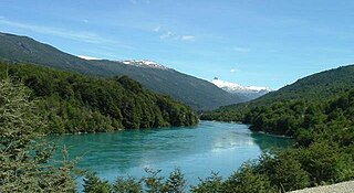
The Cisnes River is a river located in the Aysén del General Carlos Ibáñez del Campo Region of the Chilean Patagonia. It runs in east-west direction from the mountains near the border to Argentina and empties into the Pacific Ocean, near the town of Puerto Cisnes at Puyuhuapi Channel. Its characteristic turquoise-blue color is due to the glacial sediments deposited in it. Moro River and Pinchado River are some of the major tributaries of the river.

The Wood River is a short river in the southern region of the U.S. state of Oregon, and part of the Klamath Basin drainage. It flows 18 miles (29 km) through the Fremont-Winema National Forests, Bureau of Land Management land, and private property in southern Oregon. Its watershed consists of 220 square miles (570 km2) of conifer forest, rural pasture land, and marsh. The river provides habitat for many species of wildlife including an adfluvial (migratory) and resident populations of native Great Basin redband trout.
The Palena River or Carrenleufú is a river shared by Chile and Argentina in Northern Patagonia. It drains the waters of the Vintter Lake, also shared by these nations, and it flows into the Pacific Ocean. 56.5% of the river basin lies in Chile.
Irrigation in Iran covers 89,930 km2 making it the fifth ranked country in terms of irrigated area.
The Canal Lauca is an artificial channel to divert the waters of the Lauca River westward through a canal and tunnel into the Azapa Valley for purposes of irrigation in the valley and hydroelectric-power generation. Its construction began 1948 and water diversion began 14 years later from a dam located about 16 miles southwest of Lago Cotacotani Lake.
The Middle Rio Grande Conservancy District (MRGCD) was formed in 1925 to manage the irrigation systems and control floods in the Albuquerque Basin. It is responsible for the stretch of river from the Cochiti Dam in Sandoval County in the north, through Bernalillo County, Valencia County and Socorro County to the Elephant Butte Reservoir in the south. It manages the Angostura, Isleta and San Acacia diversion dams, which feed an extensive network of irrigation canals and ditches.
References
- 1 2 (in Spanish) Cuenca del río Loa Archived 2015-09-24 at the Wayback Machine
- 1 2 Cuenca del río Biobío Archived 2015-05-13 at the Wayback Machine
- 1 2 "Cuenca del río Maule" (PDF). Archived from the original (PDF) on 2009-03-06. Retrieved 2008-09-29.
- 1 2 Cuenca del río Bueno Archived 2015-09-24 at the Wayback Machine
- 1 2 Cuenca del río Maipo Archived 2012-02-12 at the Wayback Machine
- ↑ Cuenca del río Rapel Archived 2011-09-30 at the Wayback Machine
- 1 2 3 Cuenca del río Limarí Archived 2012-03-24 at the Wayback Machine
- 1 2 "Cuenca del río Imperial" (PDF). Archived from the original (PDF) on 2012-10-10. Retrieved 2008-01-29.
- 1 2 Río Aysén Archived 2007-12-08 at the Wayback Machine
- 1 2 "Cuenca del río Copiapó" (PDF). Archived from the original (PDF) on 2015-09-24. Retrieved 2008-01-29.
- 1 2 Cuenca de rio Itata Archived 2007-09-27 at the Wayback Machine
- 1 2 "Cuenca del río Valdivia" (PDF). Archived from the original (PDF) on 2007-09-27. Retrieved 2008-01-29.