Arizona

The following list contains the most notable road interchanges within the United States divided by each state, which are mainly part of the national Interstate Highway System and are all freeways intersecting with each other at a junction.
Some of the biggest ones are: Kennedy Interchange (I-64/I-65/I-71) in Louisville, Kentucky; the Marquette Interchange (I-94/I-43/I-794) and the $1.8 billion Zoo Interchange both in Milwaukee, Wisconsin; the Pregerson Interchange (I-110/I-105) in Los Angeles; and the Circle Interchange (I-90/I-94/I-290) in Chicago. [1]
The first stack interchange in the world was the Four Level Interchange (renamed the Bill Keene Memorial Interchange), built in Los Angeles, California, and completed in 1949, at the junction of U.S. Route 101 and State Route 110. [3] Since then, the California Department of Transportation (Caltrans) has built at least eight more four-level stacks throughout the state of California, as well as a larger number of three-level stack/cloverleaf hybrids (where the least-used left-turning ramp is built as a cloverleaf-like 270-degree loop).
Despite the construction of interchanges smoothing flow, 11 of the top 30 most congested stretches of highway in the U.S. are in Los Angeles. [4]


Route 23 is a state highway in the northern part of New Jersey, United States. The route runs 52.63 mi (84.70 km) from County Route 506 and County Route 577 in Verona, Essex County northwest to the border with New York at Montague Township in Sussex County, where the road continues to Port Jervis, New York, as Orange County Route 15. Route 23 heads through Essex and Passaic Counties as a suburban arterial varying from two to four lanes and becomes a six-lane freeway north of a complex interchange with U.S. Route 46 and Interstate 80 in Wayne. The freeway carries Route 23 north to a concurrency with U.S. Route 202. Past the freeway portion, the route heads northwest along the border of Morris and Passaic Counties as a four- to six-lane divided highway with a wide median at places, winding through mountainous areas and crossing Interstate 287 in Riverdale. The route continues northwest through Sussex County as a mostly two-lane, undivided road that passes through farmland and woodland as well as the communities of Franklin, Hamburg, and Sussex before reaching the New York state line, just south of an interchange with Interstate 84 and US 6 in Port Jervis, in Montague Township near High Point State Park.
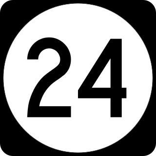
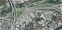
Route 24 is a 10.42-mile (16.77 km) freeway in New Jersey, United States, that begins at a junction with Interstate 287 (I-287) in Hanover Township in Morris County, passes southeast through Essex County, and ends at a junction with I-78 in Springfield Township in Union County.
An overpass is a bridge, road, railway or similar structure that crosses over another road or railway. An overpass and underpass together form a grade separation. Stack interchanges are made up of several overpasses.

Route 110, consisting of State Route 110 (SR 110) and Interstate 110 (I-110), is a state and auxiliary Interstate Highway in the Los Angeles metropolitan area of the US state of California. The entire route connects San Pedro and the Port of Los Angeles with Downtown Los Angeles and Pasadena. The southern segment from San Pedro to I-10 in downtown Los Angeles is signed as I-110, while the northern segment to Pasadena is signed as SR 110. The entire length of I-110, as well as SR 110 south of the Four Level Interchange with US Route 101 (US 101), is the Harbor Freeway, and SR 110 north from US 101 to Pasadena is the historic Arroyo Seco Parkway, the first freeway in the western United States.

The Santa Ana Freeway is one of the principal freeways in Southern California, connecting Los Angeles and its southeastern suburbs including the freeway's namesake, the city of Santa Ana. The freeway begins at its junction with the San Diego Freeway, called the El Toro Y, in Irvine, signed as I-5. From there, it generally goes southeast to northwest to the East Los Angeles Interchange, where it takes the designation of U.S. Route 101 (US 101). It then proceeds 2.95 miles (4.75 km) northwest to the Four Level Interchange in downtown Los Angeles. Formerly, the entirety of the route was marked as US 101 until the 1964 highway renumbering, which truncated US 101 to the East Los Angeles Interchange and designated the rest of the freeway as I-5.

Interstate 105 (I-105) is an east–west auxiliary Interstate Highway in the Greater Los Angeles urban area of Southern California. It runs from State Route 1 (SR 1) near El Segundo and Los Angeles International Airport (LAX) to I-605 in the City of Norwalk. It is commonly known as the Century Freeway after Century Boulevard which it parallels, and also officially known as the Glenn Anderson Freeway after the late congressman Glenn M. Anderson who advocated for its construction.

A cloverleaf interchange is a two-level interchange in which all turns are handled by slip roads. To go left, vehicles first continue as one road passes over or under the other, then exit right onto a one-way three-fourths loop ramp (270°) and merge onto the intersecting road. The objective of a cloverleaf is to allow two highways to cross without the need for any traffic to be stopped by traffic lights. The limiting factor in the capacity of a cloverleaf interchange is traffic weaving.
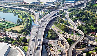
Spaghetti junction is a nickname sometimes given to a complex or massively intertwined road traffic interchange that is said to resemble a plate of spaghetti. Such interchanges may incorporate a variety of interchange design elements in order to maximize connectivity.

The Four Level Interchange is the first stack interchange in the world. Completed in 1949 and fully opened in 1953 at the northern edge of Downtown Los Angeles, California, United States, it connects U.S. Route 101 to State Route 110. In 2006, the interchange was officially renamed in the memory of Los Angeles traffic and weather reporter Bill Keene.

The Southern California freeways are a vast network of interconnected freeways in the megaregion of Southern California, serving a population of 23 million people. The Master Plan of Metropolitan Los Angeles Freeways was adopted by the Regional Planning Commission in 1947 and construction began in the early 1950s. The plan hit opposition and funding limitations in the 1970s, and by 2004, only some 61% of the original planned network had been completed.

Interstate 84 (I-84) is an Interstate Highway in the Northeastern United States that extends from Dunmore, Pennsylvania, at an interchange with I-81 east to Sturbridge, Massachusetts, at an interchange with the Massachusetts Turnpike (I-90). Among the major cities that the road passes through is Hartford, Connecticut, and the road provides a major portion of the primary route between New York City and Boston. Another highway named I-84 is located in the Northwestern United States.

State Highway 66 is a 192.7-mile (310.1 km) state highway in the U.S. state of Oklahoma, beginning at U.S. Highway 81 in El Reno and ending at U.S. Highway 60 near White Oak. The highway was designated in 1985 as a replacement for the decommissioned U.S. Highway 66. Although most of the highway follows Historic Route 66, the highway follows US 66's final alignment, joining Interstate 44 through Tulsa and Oklahoma City, while older versions of the route follow various city streets through both cities.

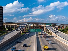
In the field of road transport, an interchange or a grade-separated junction is a road junction that uses grade separations to allow for the movement of traffic between two or more roadways or highways, using a system of interconnecting roadways to permit traffic on at least one of the routes to pass through the junction without interruption from crossing traffic streams. It differs from a standard intersection, where roads cross at grade. Interchanges are almost always used when at least one road is a controlled-access highway or a limited-access divided highway (expressway), though they are sometimes used at junctions between surface streets.
A directional interchange, colloquially known as a stack interchange, is a type of grade-separated junction between two controlled-access highways that allows for free-flowing movement to and from all directions of traffic. These interchanges eliminate the problems of weaving, have the highest vehicle capacity, and vehicles travel shorter distances when compared to different types of interchanges.

Route 8 is a 67.36-mile (108.41 km) state highway in Connecticut that runs north–south from Bridgeport, through Waterbury, all the way to the Massachusetts state line where it continues as Massachusetts Route 8. Most of the highway is a four-lane freeway but the northernmost 8.8 miles (14.2 km) is a two-lane surface road.
Route 2 is a 58.03-mile (93.39 km) state highway in Hartford and New London counties in Connecticut. It is a primary state route, with a freeway section connecting Hartford to Norwich and following surface roads to Stonington. The entire freeway section of Route 2 is also known as the Veterans of Foreign Wars Memorial Highway.

Exit numbers in the United States are assigned to freeway junctions, and are usually numbered as exits from freeways. Exit numbers generally are found above the destinations and route number(s) at the exit, as well as a sign in the gore. Exit numbers typically reset at political borders such as state lines. Some major streets also use exit numbers. Freeway exits in the United States are usually numbered in two formats: distance-based and sequential.

The Judge Harry Pregerson Interchange is a stack interchange near the Athens and Watts communities of Los Angeles, California. It is the interchange of the following routes:
Interstate 84 (I-84) is an east–west Interstate Highway across the state of Connecticut through Danbury, Waterbury, Hartford, and Union.