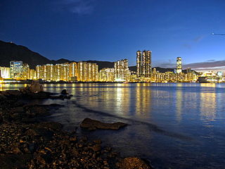
The Eastern District located on north-eastern part of Hong Kong Island, being one of the 18 administrative districts of Hong Kong. It had a population of 529,603 in 2021 The district has the second highest population while its residents have the third highest median household income among 18 districts.
Causeway Bay is an area and a bay on Hong Kong Island, Hong Kong, straddling the border of the Eastern and the Wan Chai districts. It is a major shopping, leisure and cultural centre in Hong Kong, with a number of major shopping centres. The rents in the shopping areas of Causeway Bay were ranked as the world's most expensive for the second year in a row in 2013, after overtaking New York City's Fifth Avenue in 2012. When referring to the area, the Cantonese name is never written in English as "Tung Lo Wan".

Kowloon City is an area in New Kowloon, Hong Kong. It is part of Kowloon City District.
Tsuen Wan District is one of the 18 districts of Hong Kong. It is located in the New Territories and is served by the Tsuen Wan line of the MTR metro system. Its area is 60,7 km². Its residents, who mostly live in Tsuen Wan Town, enjoy the highest income in the New Territories.

Sai Kung District is one of the 18 districts of Hong Kong. The district comprises the southern half of the Sai Kung Peninsula, the Clear Water Bay Peninsula in the New Territories and a strip of land to the east of Kowloon. Areas in the district include Sai Kung Town, Hong Kong UNESCO Global Geopark, Tseung Kwan O and over 70 islands of different sizes. The administrative centre had been located in Sai Kung Town until the Sai Kung District Office was relocated to Tseung Kwan O recently. The district's population is concentrated in Tseung Kwan O, as of 2011. In 2011, the district was the third youngest district, with a median age of 39.3. Known as the "back garden of Hong Kong", Sai Kung has been able to retain its natural scenery. Many traditional customs and cultures are still retained in the rural villages.

Kowloon Tong (Chinese: 九龍塘) is an area of Hong Kong located in Kowloon. The majority of the area is in the Kowloon City District. Its exact location is south of the Lion Rock, north of Boundary Street, east of the East Rail line and west of Grampian Road. It is one of the most expensive residential districts in Hong Kong.

Kennedy Town is at the western end of Sai Wan on Hong Kong Island in Hong Kong. It was named after Arthur Edward Kennedy, the 7th Governor of Hong Kong from 1872 to 1877. Administratively, it is part of Central and Western District.

The Urban Renewal Authority (URA) is a quasi-governmental, profit-making statutory body in Hong Kong responsible for accelerating urban redevelopment.

Lee Tung Street, known as the Wedding Card Street by locals, was a street in Wan Chai, Hong Kong. The street was famed in Hong Kong and abroad as a centre for publishing and for the manufacturing of wedding cards and other similar items.

Ladder Street is a street in the Central and Western District of Hong Kong, consisting entirely of steps and landings formed by granite slabs or concrete paving. It was so named because it extends straight up and down like a ladder. The street has been listed as a Grade I historic building.

Lai Chi Kok Road is a road in western Kowloon, Hong Kong. It links Lai Chi Kok to Mong Kok, via Tai Kok Tsui, Sham Shui Po and Cheung Sha Wan. It starts from a junction with Nathan Road near Pioneer Centre in the south and ends near Mei Foo Sun Chuen. The road is bidirectional except the section at Lai Chi Kok, between the junction with Butterfly Valley Road and Mei Foo Sun Chuen, where it serves New Territories-bound traffic only. The Kowloon-bound traffic uses Cheung Sha Wan Road, separated by the flyover of Kwai Chung Road. The road once hosted shipyards, fish, meat and vegetable wholesale markets, which were moved closer to the coast after extensive reclamation.

Queensway is a major road in the Admiralty area of Central, Hong Kong. It was originally a section of Queen's Road East and forms part of the continuum of Queen's Road that had been split into Queen's Road West, Queen's Road Central, Queensway, and Queen's Road East after World War II. At its western end it splits into Queen's Road Central and Des Voeux Road Central while at its eastern end it merges into Hennessy Road, at the junction with Queen's Road East.

Tai Po New Town, or Tai Po Town, is a new town and non-administrative area in Tai Po District, in the New Territories, Hong Kong. The area is a planned town that surrounding the existing indigenous market towns Tai Po Hui and Tai Po Kau Hui, as well as east of the existing indigenous villages that located on the Lam Tsuen Valley as well as west of those villages in Ting Kok and Tai Mei Tuk and south of those villages in Nam Hang, Fung Yuen and Sha Lo Tung. Most of the lands of the new town were obtained by land reclamation. In present day, Tai Po New Town was simply known as Tai Po. The new town are largely covered by the government Tai Po Outline Zoning Plan, which legally regulated the land use of the area, on top of the terms in the land lease contract with the government. Some of the land lease within the area, were known as Tai Po Town Lot № foo. In election, the town had a different zoning scheme for the election constituencies.
Smithfield is a street with a length of approximately 1,300 m in Kennedy Town, Hong Kong Island, Hong Kong. Its northern section is a commercial and residential area, while its southern section is a road connecting it to Pok Fu Lam Road. Smithfield was historically the site of a cattle quarantine depot and a slaughterhouse, and was probably named after its London namesake.

Hong Kong House, also known since 1995 as the Hong Kong Economic and Trade Office, Sydney, is a landmark heritage building and former hotel in the Sydney central business district, City of Sydney, New South Wales, Australia. Built in 1891 to a design by Ambrose Thornley, it is located on 80 Druitt Street, at the corner with York Street, and is adjacent to other prominent heritage landmarks, the Sydney Town Hall and the Queen Victoria Building. Formerly known as Gresham Hotel, the property was added to the New South Wales State Heritage Register on 2 April 1999.

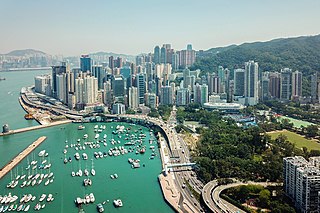
The Central and Western District located on northwestern part of Hong Kong Island is one of the 18 administrative districts of Hong Kong. It had a population of 243,266 in 2016. The district has the most educated residents with the second highest income and the third lowest population due to its relatively small size.
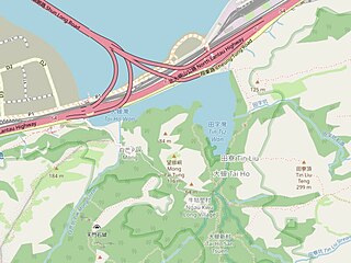
Tai Ho Wan or Tai Ho Bay is a bay on the north shore of Lantau Island in the New Territories of Hong Kong. It is located west of Siu Ho Wan, and northeast of Tung Chung and Kei Tau Kok. The surrounding land was originally planned to be part of the North Lantau New Town scope, but there is a current slowdown in its plans because of the lack in population growth and environmental groups opposed to the next in abeyance.
Ngau Tam Mei, also known as Yau Tam Mei (攸潭尾), is a suburb located in San Tin, New Territories, Hong Kong near Yuen Long. It is located at the east of Fairview Park, the north of San Tin village and Kai Kung Leng, the northwest of Lam Tsuen Country Park, and also at the northeast of Nam Sang Wai.

Lugard Road is a road located on Victoria Peak, Hong Kong, named after Sir Frederick Lugard, Governor of Hong Kong from 1907 to 1912. Located some 400 metres (1,300 ft) above sea level, the road is a popular walking path that forms part of the Hong Kong Trail, and is known for spectacular vistas over Victoria Harbour.
The Four Hills of Kowloon are four hills that were historically the site of granite quarries in Kwun Tong District, New Kowloon, Hong Kong.


