
The Republic of Suriname has a number of forms of transport. Transportation emissions are an increasing part of Suriname's contributions to climate change, as part of the Nationally Determined Contributions for the Paris Agreement, Suriname has committed to emissions controls for vehicles and increased public transit investment.

The Maroni or Marowijne is a river in South America that forms the border between French Guiana and Suriname.

The Aluku are a Bushinengue ethnic group living mainly on the riverbank in Maripasoula in southwest French Guiana. The group are sometimes called Boni, referring to the 18th-century leader, Bokilifu Boni.
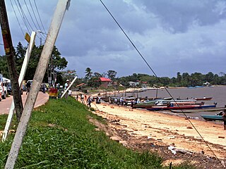
Albina is a town in eastern Suriname, and is capital of the Marowijne District. The town lies on the west bank of the Marowijne river, which forms the border with French Guiana, directly opposite the French Guianan town of Saint-Laurent-du-Maroni, to which it is connected by a frequent ferry service. Albina can be reached by bus via the East-West Link. The distance between Paramaribo and Albina is about 150 kilometres (95 mi).

Cottica Lawa, often shortened to Cottica and also called Cotticadorp is a village in the district of Sipaliwini, Suriname. It is located in the east, along the Marowijne River and the border with French Guiana. The village has a school, and a clinic.

Tapanahoni is a resort in Suriname, located in the Sipaliwini District. Its population at the 2012 census was 13,808. Tapanahoni is a part of Sipaliwini which has no capital, but is directly governed from Paramaribo. Tapanahony is an enormous resort which encompasses a quarter of the country of Suriname. The most important town is Diitabiki which is the residence of the granman of the Ndyuka people since 1950, and the location of the oracle.

Benzdorp is a village in the Sipaliwini District of Suriname. It is named after the English consul and bullion dealer H.J.W. Benz.

Maripasoula, previously named Upper Maroni, is a commune of French Guiana, an overseas region and department of France located in South America. With a land area of 18,360 km2 (7,090 sq mi), Maripasoula is the largest commune of France. The commune is slightly larger than the country of Kuwait or the U.S. state of New Jersey.

Papaichton is a commune in the overseas region and department of French Guiana. The village lies on the shores of the Lawa River. Papaichton is served by the Maripasoula Airport.
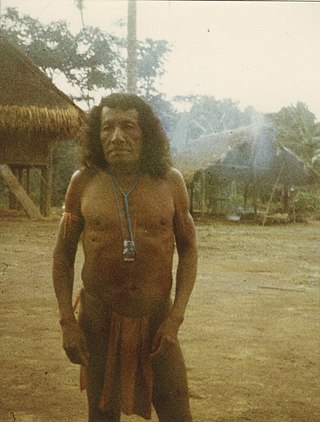
The Wayana are a Carib-speaking people located in the southeastern part of the Guiana highlands, a region divided between Brazil, Suriname, and French Guiana. In 1980, when the last census took place, the Wayana numbered some 1,500 individuals, of which 150 in Brazil, among the Apalai, 400 in Suriname, and 1,000 in French Guiana, along the Maroni River. About half of them still speak their original language.
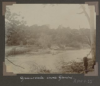
Gonini River is a river of Suriname which flows into the Lawa River near Mofina in French Guiana. The river is formed from a confluence between the Wilhelmina River and the Emma River. Both rivers are sourced from the Oranjegebergte which in turn is a subdivision of the Tumuk Humak Mountains. The area was first explored by A. Franssen Herderschee in 1903. The river is home to the Koloegado, Lenabari, Makoe-makoe, and Kotilolo waterfalls.

The Lawa is a river of South America. It forms part of the international boundary between Suriname and French Guiana. It is formed by the confluence of the Litani and Malani. Downstream from its confluence with the Tapanahony, it is called Maroni. The total length of Litani, Lawa and Maroni is 612 km (380 mi). Important tributaries are the Tampok, Inini and Grand Abounami.
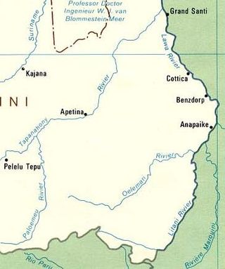
Oelemari River is a river of Suriname. The Oelemari River flows into the Litani which is a tributary to the Marowijne. The river is sourced from the Oranjegebergte which in turn is a subdivision of the Tumuk Humak Mountains. Gold has been discovered in the area and is being exploited by Guardian Exploration from Texas.

The borders of Suriname consist of land borders with three countries: Guyana, Brazil, and France. The borders with Guyana and France are in dispute, but the border with Brazil has been uncontroversial since 1906.

Lensidede or Lessé Dédé, is a Surinamese village on an island in the Lawa River, near the Lensidede rapids after which the village was named. In the village live Wayana people.
Kumakahpan is a Wayana village in the Sipaliwini District of Suriname. The village lies on the banks of the Lawa River, which forms the border with French Guiana.

Boniville is a village of Aluku Maroons in the commune of Papaïchton located on the Lawa River in French Guiana.

The Malani, also Marouini, is a river in the disputed area between French Guiana and Suriname. According to Suriname, it is the border river, however France considers the Litani the border. The river has its source at Pic Coudreau in the Tumuk Humak Mountains. It has its mouth at the confluence with the Litany at Antecume Pata and continues its journey as the Lawa River. The Malani has a length of 245 kilometres (152 mi).
