Litchfield, New York

Last updated

Litchfield, New York
Litchfield Herkimer NY.png
Location of Litchfield in Herkimer County
USA New York location map.svg
Red pog.svg
Litchfield
Usa edcp location map.svg
Red pog.svg
Litchfield
Coordinates: 42°58′40″N75°8′44″W / 42.97778°N 75.14556°W / 42.97778; -75.14556
CountryUnited States
State New York
County Herkimer
Area
[1]
  Total30.05 sq mi (77.84 km2)
  Land29.99 sq mi (77.68 km2)
  Water0.06 sq mi (0.16 km2)
Elevation
1,496 ft (456 m)
Population
 (2010)
  Total1,513
  Estimate 
(2019) [2]
1,461
  Density49.65/sq mi (19.17/km2)
Time zone UTC-5 (Eastern (EST))
  Summer (DST) UTC-4 (EDT)
FIPS code 36-043-42664
GNIS feature ID0979156
Website www.townoflitchfield.com

Litchfield is a town in Herkimer County, New York, United States. The population was 1,513 at the 2010 census. [3] The town is named after Litchfield, Connecticut, the source of some early settlers of the city.

Contents

The town of Litchfield is in the southwestern part of the county and is southeast of Utica.

History

Settlement began around 1786 at Wheelocks Hill.

The town of Litchfield was established from part of the town of German Flatts in 1796. Part of the town was used to form the town of Winfield in 1816.

12-year-old Sara Anne Wood disappeared from Litchfield in 1993.

"Litchfield Penitentiary", a fictional women's prison in Litchfield, is the setting for the Netflix original series Orange Is the New Black . [4]

Geography

According to the United States Census Bureau, the town has a total area of 30.0 square miles (77.8 km2), of which 30.0 square miles (77.7 km2) are land and 0.1 square miles (0.2 km2), or 0.20%, are water. [3]

The western town line is the border of Oneida County.

Demographics

Historical population
CensusPop.Note
1820 1,729
1830 1,7501.2%
1840 1,672−4.5%
1850 1,6760.2%
1860 1,520−9.3%
1870 1,384−8.9%
1880 1,218−12.0%
1890 1,055−13.4%
1900 931−11.8%
1910 803−13.7%
1920 747−7.0%
1930 712−4.7%
1940 7799.4%
1950 776−0.4%
1960 96324.1%
1970 961−0.2%
1980 1,18723.5%
1990 1,41419.1%
2000 1,4643.5%
2010 1,5133.3%
2019 (est.)1,461 [2] −3.4%
U.S. Decennial Census [5]

As of the census [6] of 2000, there were 1,453 people, 515 households, and 399 families residing in the town. The population density was 49.1 inhabitants per square mile (19.0/km2). There were 670 housing units at an average density of 22.6 per square mile (8.7/km2). The racial makeup of the town was 98.62% White, 0.07% African American, 0.55% Native American, 0.21% Asian, 0.07% from other races, and 0.48% from two or more races. Hispanic or Latino of any race were 0.62% of the population.

There were 515 households, out of which 39.0% had children under the age of 18 living with them, 67.0% were married couples living together, 5.2% had a female householder with no husband present, and 22.5% were non-families. 17.5% of all households were made up of individuals, and 5.8% had someone living alone who was 65 years of age or older. The average household size was 2.82 and the average family size was 3.18.

In the town, the population was spread out, with 29.3% under the age of 18, 5.8% from 18 to 24, 29.4% from 25 to 44, 24.8% from 45 to 64, and 10.7% who were 65 years of age or older. The median age was 37 years. For every 100 females, there were 104.1 males. For every 100 females age 18 and over, there were 107.1 males.

The median income for a household in the town was $42,404, and the median income for a family was $48,750. Males had a median income of $30,163 versus $23,587 for females. The per capita income for the town was $16,431. About 5.3% of families and 9.7% of the population were below the poverty line, including 17.3% of those under age 18 and 6.9% of those age 65 or over.

Notable people

Communities and locations in Litchfield

Related Research Articles

<span class="mw-page-title-main">Columbia, New York</span> Town in New York, United States

Columbia is a town in Herkimer County, New York, United States. As of the 2010 census, the town population was 1,580. The town is at the southern border of the county and is southeast of Utica.

<span class="mw-page-title-main">Danube, New York</span> Town in New York, United States

Danube is a town in Herkimer County, New York, United States. The population was 1,039 at the 2010 census. Early Palatine German immigrants in the eighteenth century named the town after the Danube River in Europe.

<span class="mw-page-title-main">Fairfield, New York</span> Town in New York, United States

Fairfield is a town in Herkimer County, New York, United States. The population was 1,627 at the 2010 census. The town is named after Fairfield, Connecticut.

<span class="mw-page-title-main">German Flatts, New York</span> Town in Herkimer County, New York, US

German Flatts is a town in Herkimer County, New York, United States. The population was 13,258 at the 2010 census.

<span class="mw-page-title-main">Manheim, New York</span> Town in New York, United States

Manheim is a town in Herkimer County, New York, United States. The population was 3,334 at the 2010 census. The town name is derived from Mannheim in Baden, Germany.

<span class="mw-page-title-main">Ohio, New York</span> Town in New York, United States

Ohio is a town in Herkimer County, New York, United States. The population was 1,002 at the 2010 census. The town is named after the state of Ohio. The town is in the northern part of the county and northeast of Utica. Part of Ohio is within the Adirondack Park.

<span class="mw-page-title-main">Russia, New York</span> Town in New York, United States

Russia is a town in Herkimer County, New York, United States. The population was 2,587 at the 2010 census. The town is located in the northwestern part of the county and is northeast of Utica.

<span class="mw-page-title-main">Salisbury, Herkimer County, New York</span> Town in New York, United States

Salisbury is a town in Herkimer County, New York, United States. The population was 1,958 at the 2010 census. The town is on the eastern edge of the county, north of the city of Little Falls. The northern part of the town is in the Adirondack Park.

<span class="mw-page-title-main">Schuyler, New York</span> Town in Herkimer County, New York, US

Schuyler is a town in Herkimer County, New York, United States. The population was 3,420 at the 2010 census. The town is in the western part of Herkimer County and is east of Utica.

<span class="mw-page-title-main">Stark, New York</span> Town in New York, United States

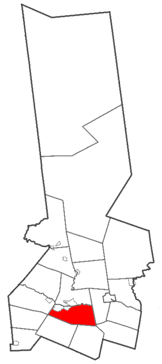
Stark is a town in Herkimer County, New York, United States. The population was 757 at the 2010 census. The town was named after Revolutionary War general John Stark.

<span class="mw-page-title-main">Warren, New York</span> Town in Herkimer County, New York, US

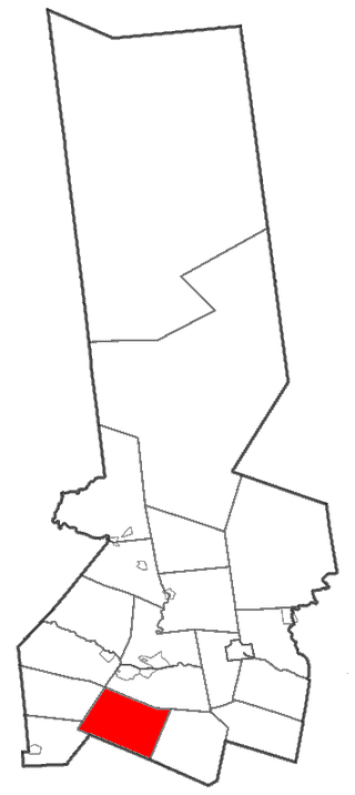
Warren is a town in Herkimer County, New York, United States. The population was 1,143 at the 2010 census. The town is named after General Joseph Warren, who was killed at the Battle of Bunker Hill. Warren is in the south part of Herkimer County. US 20 passes across the town.

<span class="mw-page-title-main">Winfield (town), New York</span> Town in New York, United States

Winfield is a town in Herkimer County, New York, United States. The population was 2,086 at the 2010 census. The town is named after General Winfield Scott and is in the southwestern corner of the county, south of Utica. "The town has recently been certified a Clean Energy Community."

Watson is a town in Lewis County, New York, United States. The population was 1,881 at the 2010 census. The town is named after early landowner James Watson. The town is at the eastern border of the county and is east of Lowville, the county seat.

<span class="mw-page-title-main">Deerfield, New York</span> Town in New York, United States

Deerfield is a town in Oneida County, New York, United States. The population was 4,273 at the 2010 census.

Enfield is a town in Tompkins County, New York, United States. The population was 3,401 at the 2020 census.

<span class="mw-page-title-main">Ripley, New York</span> Town in New York, United States

Ripley is a town on Lake Erie in the westernmost part of Chautauqua County, New York, United States. The population was 2,310 at the time of the 2020 census. The town was named after Eleazer Wheelock Ripley, a general in the War of 1812. There are no incorporated villages in the town, but there is one census-designated place: the hamlet of Ripley. The town is perhaps best known as being the western end of the New York State Thruway.

<span class="mw-page-title-main">Frankfort (town), New York</span> Town in New York, United States

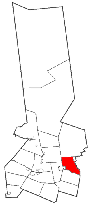
Frankfort is a town in Herkimer County, New York, United States. The town is named after one of its earliest settlers, Lawrence (Lewis) Frank. The town of Frankfort includes a village, also called Frankfort. Frankfort is located east of Utica, and the Erie Canal passes along its northern border. At the time of the 2010 census, the population was 7,636.

<span class="mw-page-title-main">Herkimer (town), New York</span> Town in New York, United States

Herkimer is a town in Herkimer County, New York, United States, southeast of Utica. It is named after Nicholas Herkimer. The population was 10,175 at the 2010 census.

<span class="mw-page-title-main">Newport, New York</span> Town in New York, United States

Newport is a town in Herkimer County, New York, United States. The population was 2,302 at the 2010 census. The town, located on the western edge of the county, contains the village of Newport. The town is northeast of Utica.

<span class="mw-page-title-main">Bridgewater, New York</span> Town in New York, United States

Bridgewater is a town in Oneida County, New York, United States. The population was 1,522 at the 2010 census.

References

  1. "2016 U.S. Gazetteer Files". United States Census Bureau. Retrieved July 5, 2017.
  2. 1 2 "Population and Housing Unit Estimates" . Retrieved November 10, 2020.
  3. 1 2 "Geographic Identifiers: 2010 Census Summary File 1 (G001): Litchfield town, Herkimer County, New York". American Factfinder. U.S. Census Bureau. Archived from the original on February 13, 2020. Retrieved November 29, 2017.
  4. Cooper, Anneliese (June 6, 2014). "'Orange Is the New Black's Prison Location Isn't Real, But It's Not Entirely Fictional Either". Bustle . Retrieved August 4, 2017. "The show, which is based on Piper Kerman's memoir of the same title, is set vaguely in upstate New York at "Litchfield Correctional Facility" —"
  5. "Census of Population and Housing". Census.gov. Retrieved June 4, 2015.
  6. "U.S. Census website". United States Census Bureau . Retrieved January 31, 2008.
  7. Association of Graduates (1938). Annual Report of the Association of Graduates of the United States Military Academy at West Point. Newburgh, NY: Moore Printing Company. pp. 318–319.
  8. "Death of an Old Settler". The Marengo Republican. Marengo, IL. January 5, 1900. p. 4 via Newspapers.com.
  9. History of Walworth County, Wisconsin. Chicago: Western Historical Company. 1882. p.  634 . Retrieved June 19, 2015. Newton Littlejohn+Wisconsin.
  10. "Numbered with the Dead". Chicago Tribune . p. 9. Retrieved July 25, 2021 via Newspapers.com. Open Access logo PLoS transparent.svg
  11. "Underwood, John C. (1809–1873)". www.encyclopediavirginia.org.