Little River, South Carolina

Last updated

Little River, South Carolina
CDP
SCMap-doton-LittleRiver.PNG
Location of Little River in South Carolina
Coordinates: 33°52′18″N78°37′40″W / 33.87167°N 78.62778°W / 33.87167; -78.62778
Country United States
State South Carolina
County Horry
Area
[1]
  Total10.82 sq mi (28.03 km2)
  Land10.48 sq mi (27.14 km2)
  Water0.34 sq mi (0.89 km2)
Elevation
39 ft (12 m)
Population
 (2020) [2]
  Total11,711
  Density1,117.57/sq mi (431.49/km2)
Time zone UTC-5 (EST)
  Summer (DST) UTC-4 (EDT)
ZIP code
29566
Area code(s) 843, 854
FIPS code 45-42010 [3]
GNIS feature ID1231489 [4]
Website www.littleriversc.com

Little River is a census-designated place (CDP) in Horry County, South Carolina, United States. The population was 11,711 at the 2020 census.

Contents

Little River is named for the Little River, which flows into the Atlantic Ocean at the state line between North Carolina and South Carolina. The Little River inlet has long been a breakpoint for tropical cyclone warnings.

Geography

Little River is located at 33°52′18″N78°37′40″W / 33.87167°N 78.62778°W / 33.87167; -78.62778 (33.871629, -78.627733). [5]

According to the United States Census Bureau, the CDP has a total area of 10.8 square miles (28.0 km2), of which 10.5 square miles (27.1 km2) is land and 0.4 square mile (0.9 km2) (3.33%) is water. The area is mainly made up of housing developments, old scrub pine forests, marshes and swamps and is bordered by the Waccamaw River and the Atlantic Intracoastal waterway. Live oaks, Spanish moss, crepe myrtle trees and palm trees dot the landscape.

Demographics

Historical population
CensusPop.Note
2020 11,711
U.S. Decennial Census [6]

2020 census

Little River racial composition [7]
RaceNum.Perc.
White (non-Hispanic)9,87384.31%
Black or African American (non-Hispanic)6695.71%
Native American 620.53%
Asian 1160.99%
Pacific Islander 150.13%
Other/Mixed 4704.01%
Hispanic or Latino 5064.32%

As of the 2020 United States census, there were 11,711 people, 4,885 households, and 2,633 families residing in the CDP.

2000 census

As of the census [3] of 2000, there were 7,027 people, 3,287 households, and 2,225 families residing in the CDP. The population density was 671.9 inhabitants per square mile (259.4/km2). There were 4,715 housing units at an average density of 450.8 per square mile (174.1/km2). The racial makeup of the CDP was 91.40% White, 6.80% African American, 0.43% Native American, 0.28% Asian, 0.04% Pacific Islander, 0.34% from other races, and 0.70% from two or more races. Hispanic or Latino, of any race, were 1.02% of the population.

There were 3,287 households, out of which 18.6% had children under the age of 18 living with them, 57.0% were married couples living together, 8.4% had a female householder with no husband present, and 32.3% were non-families. 26.0% of all households were made up of individuals, and 10.5% had someone living alone who was 65 years of age or older. The average household size was 2.14 and the average family size was 2.53.

In the CDP, the population was spread out, with 15.7% under the age of 18, 4.7% from 18 to 24, 24.2% from 25 to 44, 31.9% from 45 to 64, and 23.4% who were 65 years of age or older. The median age was 49 years. For every 100 females, there were 92.7 males. For every 100 females age 18 and over, there were 91.8 males.[ clarification needed ]

The median income for a household in the CDP was $40,427, and the median income for a family was $45,243. Males had a median income of $36,086 versus $22,348 for females. The per capita income for the CDP was $22,733. About 4.7% of families and 7.5% of the population were below the poverty line, including 15.3% of those under age 18 and 1.7% of those age 65 or over.

Arts and culture

The community is host to an annual Blue Crab Festival each May.

During the 21 years that South Carolina had legalized video poker, Little River's location near the North Carolina state line made the community a major center for the activity. In 1996, local churches began protesting legalized gambling in what had become Little Reno, and the state outlawed the games in 2000. Two years before the video poker ban, casino boats began operating and continue to do so in federal waters because the state has not specifically banned them. Little River has the state's only casino boat, The Big M Casino. [8]

Major highways

Education

Little River has a public library, a branch of the Horry County Memorial Library. [9]

Wildlife

Little River common natural wildlife includes bobcats, lizards (geckos and anoles), amphibians (flatwoods salamander and Carolina gopher frog), non-lizard reptiles (water snakes, yellow-bellied turtles and alligators), wading birds and mammals (black bear and bobcat). [10]

Related Research Articles

<span class="mw-page-title-main">Georgetown County, South Carolina</span> County in South Carolina, United States

Georgetown County is a county located in the U.S. state of South Carolina. As of the 2020 census, the population was 63,404. Its county seat is Georgetown. The county was founded in 1769. It is named for George III of the United Kingdom.

<span class="mw-page-title-main">Woodlawn, North Carolina</span> Census-designated place in North Carolina, United States

Woodlawn is a census-designated place in Alamance County, North Carolina, United States.

<span class="mw-page-title-main">Clearwater, South Carolina</span> Census-designated place in South Carolina, United States of America

Clearwater is a census-designated place (CDP) in Aiken County, South Carolina. It lies near North Augusta, South Carolina, and is part of the Augusta, Georgia metropolitan area. Clearwater is located in historic Horse Creek Valley. The population was 4,370 at the time of the 2010 census.

<span class="mw-page-title-main">Burton, South Carolina</span> CDP in South Carolina, United States

Burton is a census-designated place (CDP) on Port Royal Island in Beaufort County, South Carolina, United States. The population was 6,976 at the 2010 census. As defined by the U.S. Census Bureau, Burton is included within the Hilton Head Island-Bluffton-Beaufort, SC Metropolitan Statistical Area.

Wade Hampton is a census-designated place (CDP) in Greenville County, South Carolina, United States. The population was 20,622 at the 2010 census. It is named for American Civil War general and South Carolina governor Wade Hampton.

<span class="mw-page-title-main">Bucksport, South Carolina</span> Census-designated place in South Carolina, United States

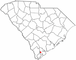
Bucksport is an unincorporated community and census-designated place (CDP) in Horry County, South Carolina, United States. The population was 876 at the 2010 census. It is a rural port on the Atlantic Intracoastal Waterway at the merger point with the Waccamaw River. The port has some services available for boaters and is also home to the Bucksport Restaurant.

<span class="mw-page-title-main">Forestbrook, South Carolina</span> Census-designated place in South Carolina, United States

Forestbrook is a census-designated place (CDP) in Horry County, South Carolina, United States. The population was 4,612 at the 2010 census, up from 3,391 at the 2000 census.

<span class="mw-page-title-main">Garden City, South Carolina</span> CDP in South Carolina, United States

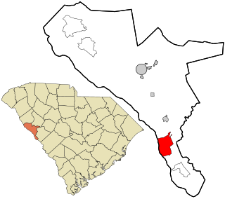
Garden City, sometimes known as Garden City Beach, is a census-designated place (CDP) in Horry County, South Carolina, United States. The population was 9,209 at the 2010 census. Garden City Beach is located directly south of Surfside Beach. The developed part of the beach extends south beyond the limits of the Garden City CDP, into Georgetown County, and ends on a peninsula at the mouth of Murrells Inlet.

<span class="mw-page-title-main">North Myrtle Beach, South Carolina</span> City in South Carolina, United States

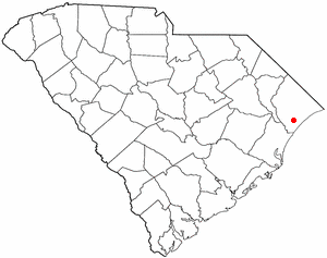
North Myrtle Beach is a city in Horry County, South Carolina, United States. It was created in 1968 from four existing municipalities, and is located about 15 miles (24 km) northeast of Myrtle Beach. It serves as one of the primary tourist destinations along the Grand Strand. As of the 2010 census, the population was 13,752, and in 2019 the estimated population was 16,819. It is part of the Myrtle Beach-Conway-North Myrtle Beach, SC Metropolitan Statistical Area, which had a combined population of 449,295 as of 2016.

<span class="mw-page-title-main">Red Hill, South Carolina</span> Census-designated place in South Carolina, United States

Red Hill is a census-designated place (CDP) in Horry County, South Carolina, United States. The population was 13,223 at the 2010 census, up from 10,509 at the 2000 census.

<span class="mw-page-title-main">Socastee, South Carolina</span> CDP in South Carolina, United States

Socastee is a census-designated place (CDP) in Horry County, South Carolina, United States. The population was 19,952 at the 2010 census.

<span class="mw-page-title-main">Joanna, South Carolina</span> Census-designated place in South Carolina, United States

Joanna is an unincorporated community and census-designated place (CDP) in Laurens County, South Carolina, United States. The population was 1,539 at the 2010 census, down from 1,609 at the 2000 census. It is part of the Greenville–Mauldin–Easley Metropolitan Statistical Area.

<span class="mw-page-title-main">Watts Mills, South Carolina</span> Census-designated place in South Carolina, United States

Wattsville is an unincorporated community in Laurens County, South Carolina, United States. The town name is derived from Watts Mill, a textile mill in the center of town. The area is listed as the Wattsville census-designated place (CDP) for statistical purposes. The population of the CDP was 1,635 at the 2010 census. It is part of the Greenville–Mauldin–Easley Metropolitan Statistical Area.

<span class="mw-page-title-main">Red Bank, South Carolina</span> Census-designated place in South Carolina, United States

Red Bank is an unincorporated community and census-designated place (CDP) in Lexington County, South Carolina, United States. The population was 9,617 at the 2010 census, up from 8,811 at the 2000 census. It is part of the Columbia, South Carolina Metropolitan Statistical Area.

Seven Oaks is a census-designated place (CDP) in Lexington County, South Carolina, United States, 8 miles (13 km) northwest of downtown Columbia, the state capital. The population of the CDP was 15,144 at the 2010 census. It is part of the Columbia Metropolitan Statistical Area.

<span class="mw-page-title-main">Modoc, South Carolina</span> CDP in South Carolina, United States

Modoc is a census-designated place (CDP) in McCormick County, South Carolina, United States. The population was 256 at the 2000 census, and 218 at the 2010 census, a decline of 14.8%.

<span class="mw-page-title-main">Willington, South Carolina</span> CDP in South Carolina, United States

Willington is a census-designated place (CDP) in McCormick County, South Carolina, United States. The population was 177 at the 2000 census.

Stateburg is a census-designated place (CDP) in the High Hills of Santee in Sumter County, South Carolina, United States. The population was 1,380 at the 2010 census. It is included in the Sumter, South Carolina Metropolitan Statistical Area. Stateburg is located within the larger Stateburg Historic District.

<span class="mw-page-title-main">Ladson, South Carolina</span> Census-designated place in South Carolina, United States

Ladson is a census-designated place (CDP) in Berkeley, Charleston and Dorchester counties in the U.S. state of South Carolina. The population was 13,790 at the 2010 census. It is named in honor of the Ladson family, one of the oldest planter and merchant families in the Charleston area; one of its members was lieutenant governor James Ladson.

East Millinocket is a census-designated place (CDP) consisting of the main settlement in the town of East Millinocket in Penobscot County, Maine, United States. The population was 1,567 at the 2010 census.

References

  1. "ArcGIS REST Services Directory". United States Census Bureau. Retrieved October 15, 2022.
  2. "Census Population API". United States Census Bureau. Retrieved October 15, 2022.
  3. 1 2 "U.S. Census website". United States Census Bureau . Retrieved January 31, 2008.
  4. "US Board on Geographic Names". United States Geological Survey. October 25, 2007. Retrieved January 31, 2008.
  5. "US Gazetteer files: 2010, 2000, and 1990". United States Census Bureau. February 12, 2011. Retrieved April 23, 2011.
  6. "Census of Population and Housing". Census.gov. Retrieved June 4, 2016.
  7. "Explore Census Data". data.census.gov. Retrieved December 15, 2021.
  8. Wilson, Zane (July 18, 2010). "Video poker debate lives on; Little River once dubbed Little Reno". The Sun News . Retrieved July 18, 2010.
  9. "Locations & Hours". Greenville County Library System. Retrieved June 8, 2019.
  10. "SCDNR - Wetlands". www.dnr.sc.gov. Retrieved August 15, 2023.