
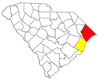
Horry County is the easternmost county in the U.S. state of South Carolina. As of the 2020 census, its population was 351,029. It is the fourth-most populous county in South Carolina. The county seat is Conway.

Georgetown County is a county located in the U.S. state of South Carolina. As of the 2020 census, the population was 63,404. Its county seat is Georgetown. The county was founded in 1769. It is named for George III of the United Kingdom.

Brunswick County is the southernmost county in the U.S. state of North Carolina. As of the 2020 census, the population was 136,693. Its population was only 73,143 in 2000, making it one of the fastest-growing counties in the state. With a nominal growth rate of approximately 47% in ten years, much of the growth is centered in the eastern section of the county in the suburbs of Wilmington such as Leland, Belville and Southport. A 2019 estimated population of 142,820 makes Brunswick the fourth-fastest-growing county in the country. The county seat is Bolivia, which at a population of around 150 people is among the least populous county seats in the state.

Caswell Beach is a small seaside town located on the Atlantic Ocean at the mouth of the Cape Fear River in Southeastern North Carolina, United States. Occupying the eastern part of Oak Island in Brunswick County, its population was listed at 395 in the 2020 census. Prominent features include the Civil War era Fort Caswell, the Oak Island Lighthouse co-located with the Oak Island Coast Guard Station, and the Oak Island Golf Club, the sole business in town and one of the few eighteen-hole courses located on a North Carolina barrier island. Along with the Town of Oak Island which occupies the central and west parts of the island, Caswell Beach is considered to be in the Myrtle Beach metropolitan area.

Ocean Isle Beach is a small seaside town located in Brunswick County, North Carolina, United States. The population was 550 at the 2010 census. It was incorporated as a town in 1959 and is part of the Myrtle Beach metropolitan area.

Hilton Head Island, sometimes referred to as simply Hilton Head, is a Lowcountry resort town and barrier island in Beaufort County, South Carolina, United States. It is 20 miles (32 km) northeast of Savannah, Georgia, and 95 miles (153 km) southwest of Charleston. The island is named after Captain William Hilton, who in 1663 identified a headland near the entrance to Port Royal Sound, which mapmakers named "Hilton's Headland." The island features 12 miles (19 km) of beachfront on the Atlantic Ocean and is a popular vacation destination. In 2004, an estimated 2.25 million visitors infused more than $1.5 billion into the local economy. The year-round population was 37,661 at the 2020 census, although during the peak of summer vacation season the population can swell to 150,000. Hilton Head Island is a primary city within the Hilton Head Island-Bluffton-Beaufort metropolitan area, which had an estimated population of 215,908 in 2020.

Briarcliffe Acres is a town in Horry County, South Carolina, United States, located between Myrtle Beach and North Myrtle Beach. The population was 457 at the 2010 census.

Garden City, sometimes known as Garden City Beach, is a census-designated place (CDP) in Horry County, South Carolina, United States. The population was 9,209 at the 2010 census. Garden City Beach is located directly south of Surfside Beach. The developed part of the beach extends south beyond the limits of the Garden City CDP, into Georgetown County, and ends on a peninsula at the mouth of Murrells Inlet.

Myrtle Beach is a coastal city on the east coast of the United States in Horry County, South Carolina. It is located in the center of a long and continuous 60-mile (97 km) stretch of beach known as "The Grand Strand" in northeastern South Carolina.

North Myrtle Beach is a city in Horry County, South Carolina, United States. It was created in 1968 from four existing municipalities, and is located about 15 miles (24 km) northeast of Myrtle Beach. It serves as one of the primary tourist destinations along the Grand Strand. As of the 2010 census, the population was 13,752, and in 2019 the estimated population was 16,819. It is part of the Myrtle Beach–Conway–North Myrtle Beach Metropolitan Area, which had a combined population of 449,295 as of 2016.

The Grand Strand is an arc of beach land on the Atlantic Ocean in South Carolina, United States, extending more than 60 miles (97 km) from Little River to Winyah Bay. It is located in Horry and Georgetown Counties on the NE South Carolina coast.

Carolina Forest is a census-designated place (CDP) in Horry County, South Carolina, United States. It was first listed as a CDP in the 2020 census with a population of 23,342.

Princess Anne is a community located in the independent city of Virginia Beach, Virginia, United States at the junction of Princess Anne Road and North Landing Road near the West Neck River. The community, which dates from 1691, was named after Princess Anne of Denmark and Norway.

The Myrtle Beach Pavilion was a historic pay-per-ride, no parking fee, 11-acre amusement park that was located in Myrtle Beach, South Carolina at the corner of 9th Avenue North and Ocean Boulevard. It was just a few blocks down from another Myrtle Beach amusement park, the Family Kingdom Amusement Park; both in the "heart" of Myrtle Beach. "The Pavilion" had well over 40 different attractions for kids and thrill-seekers alike, and included the wooden rollercoaster Hurricane: Category 5. Despite all the best efforts made by citizens to save the park, it was lost to redevelopment in 2007. While the park was officially closed and became a vacant lot on 9th Avenue and Ocean Boulevard in 2007, some of the rides and attractions were moved to Broadway at the Beach. Broadway at the Beach and the land at 9th Avenue are both owned by Burroughs & Chapin.

Cape Fear is a coastal plain and Tidewater region of North Carolina centered about the city of Wilmington. The region takes its name from the adjacent Cape Fear headland, as does the Cape Fear River which flows through the region and empties into the Atlantic Ocean near the cape. Much of the region's populated areas are found along the Atlantic beaches and the Atlantic Intracoastal Waterway, while the rural areas are dominated by farms and swampland like that of the Green Swamp. The general area can be also identified by the titles "Lower Cape Fear", "Wilmington Metropolitan Area", "Southeastern North Carolina", and "Azalea Coast". The latter name is derived from the North Carolina Azalea Festival held annually in Wilmington. Municipalities in the area belong to the Cape Fear Council of Governments.

WNMB is a radio station licensed to North Myrtle Beach, South Carolina, United States, and serves the greater Myrtle Beach area. The station is licensed by the Federal Communications Commission (FCC) to broadcast at 900 kHz with a power of 500 watts. The station previously went by the name "AM Stereo 900" and its slogan was "The Sound of North Myrtle Beach." The station most recently broadcast in high fidelity C-QUAM AM Stereo under a beach-oriented oldies format. Until August 1, 2015, WNMB was owned and operated by the family of Bill and Susi Norman who were original employees of the original WNMB when it signed on in 1972. WNMB FM existed from 1972-2000 when it was sold and the callsign changed to WEZV. Soon after, Bill Norman leased the AM station and changed the callsign to WNMB. Norman later purchased WNMB outright and continued the WNMB radio tradition on the Grand Strand. After several changes, the station broadcasts a Regional Mexican format.
The Myrtle Beach metropolitan area is a census-designated metropolitan statistical area consisting of Horry County in South Carolina and Brunswick County in North Carolina. The wider Myrtle Beach CSA includes Georgetown County, South Carolina. The region's primary cities, in order by population are Myrtle Beach, South Carolina; Conway, South Carolina; Leland, North Carolina; North Myrtle Beach, South Carolina and Georgetown, South Carolina. Also included is Oak Island, North Carolina with a permanent population of 6,783 but a summertime population of approximately 50,000.

Interstate 73 (I-73) is the designation for a future Interstate Highway in the US state of South Carolina. When completed, it will connect the Grand Strand area with the state's Interstate system.

Callawassie Island is one of hundreds of barrier and sea islands in the southeast corner in the outer coastal plain, making up a portion of Beaufort County, South Carolina.
Myrtle Beach Air Force Base was a United States Air Force base located near Myrtle Beach, South Carolina.


