
Henry Clay Sr. was an American attorney and statesman who represented Kentucky in both the U.S. Senate and House of Representatives. He was the seventh House Speaker as well as the ninth Secretary of State, also receiving electoral votes for president in the 1824, 1832, and 1844 presidential elections. He helped found both the National Republican Party and the Whig Party. For his role in defusing sectional crises, he earned the appellation of the "Great Compromiser" and was part of the "Great Triumvirate" of Congressman, alongside fellow Whig Daniel Webster and John C. Calhoun.

Clay County is a county in the U.S. state of Tennessee. As of the 2010 census, the population was 7,861. Its county seat and only incorporated city is Celina. Clay County is named in honor of American statesman Henry Clay, member of the United States Senate from Kentucky and United States Secretary of State in the 19th century. Its mayor is Dale Reagan.

Clay County is a county located in the U.S. state of Kentucky. As of the 2010 census, the population was 21,730. Its county seat is Manchester. The county was formed in 1807 and named in honor of Green Clay (1757–1826). Clay was a member of the Virginia and Kentucky State legislatures, first cousin once removed of Henry Clay, U.S. Senator from Kentucky and Secretary of State in the 19th century.
Manchester is a home rule-class city in Clay County, Kentucky, in the United States. It is the seat of its county and the home of a minimum- and medium-security federal prison. The city's population was 1,255 at the 2010 census.

Jamestown is a home rule-class city in Russell County, Kentucky, in the United States. It is the seat of its county. The population was 1,794 at the 2010 U.S. census.

Oneida is an unincorporated community and census-designated place (CDP) in Clay County, Kentucky, United States. Its population was 410 at the 2010 census. It is the home of Oneida Baptist Institute, World Animal Foundation and Monkey Hollow Wildlife Sanctuary. Goose Creek and the Red Bird River confluence to form the South Fork of the Kentucky River a few hundred yards from the center of the town.
Henry Clay High School is a public high school in Lexington, Kentucky. Opened on Main Street in 1928, it was named in honor of the Kentuckian and United States statesman, Henry Clay. The Main Street location now houses the main offices of the Fayette County Public Schools system. The school is ranked as one of the top 10 schools in the state of Kentucky and one of the top 200 magnet programs within the United States. The school's present facility on Fontaine Road opened in 1970. As of August 2016, the school principal of Henry Clay is Paul Little. There are approximately 2,400 students enrolled at Henry Clay High School.

The City of Littleton is a Home Rule Municipality located in Arapahoe, Douglas, and Jefferson counties, Colorado, United States. Littleton is the county seat of Arapahoe County and is a part of the Denver–Aurora–Lakewood, CO Metropolitan Statistical Area. The city population was 41,737 at the 2010 United States Census, ranking as the 20th most populous municipality in the State of Colorado.

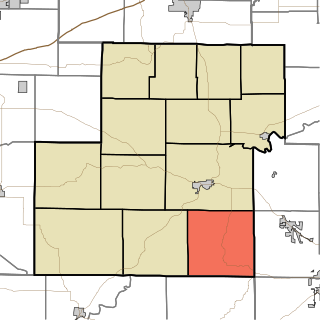
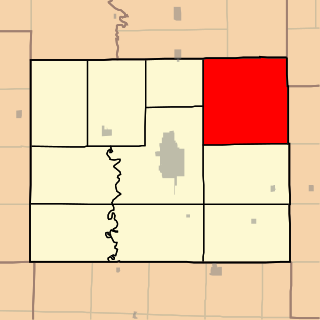
Larkinsburg Township is one of twelve townships in Clay County, Illinois, USA. As of the 2010 census, its population was 644 and it contained 296 housing units.
Clay Township is one of thirteen townships in Owen County, Indiana, United States. As of the 2010 census, its population was 2,600 and it contained 1,083 housing units.
Clay Township is one of eleven townships in Howard County, Indiana, United States. As of the 2010 census, its population was 3,885 and it contained 1,565 housing units. This township also contains a small portion of Kokomo. The population of the Kokomo portion, however, is zero.
Clay Township is one of ten townships in Adair County, Missouri, United States. As of the 2010 census, its population was 626. It is named in honor of Kentucky politician Henry Clay.

This is a list of the National Register of Historic Places listings in Clay County, Kentucky.

Henry Clay is an unincorporated community and coal town located in Pike County, Kentucky, United States. It was also known as the Henry Clay Coal Camp.
Mouth of Hector is an unincorporated community located in Clay County, Kentucky, United States. It is 817 feet above sea level. It is in the 606 area code of Kentucky.
Marcum was a post office in Clay County, Kentucky from 1908-03-11 to June 1984.
Big Creek is a 4.5 miles (7.2 km) long creek in Kentucky, United States whose headwaters are in Leslie County and that flows into the Red Bird River in Clay County. A postoffice and village are named for it. Its own name is likely purely descriptive of its frequent flooding and high water levels, as it is not otherwise one of the biggest tributaries of Red Bird River.
Beech Creek is a tributary of Goose Creek river in Clay County in the U.S. state of Kentucky. It is just under 6 miles (9.7 km) long and joins the Goose approximately ½ mile below the mouth of Laurel Creek.

