Sibert is a coal town and rail depot, and was a post office, in Clay County, Kentucky, United States located below the mouth of the Paw Paw Branch of the Horse Creek tributary of the Goose Creek river, half a mile above Hima.[2] The town, depot, and postoffice were all named after a local family who were descendants, through William and Milton Siebert, of pioneers Daniel and Sarah (Sallie) Siebert.[2]
The post office was established by Ellen Lewis on 1920-09-20, James W. McNamara its first postmaster, and closed in 1974.[2]
Clay County is a county located in the U.S. state of Kentucky. As of the 2010 census, the population was 21,730. Its county seat is Manchester. The county was formed in 1807 and named in honor of Green Clay (1757–1826). Clay was a member of the Virginia and Kentucky State legislatures, first cousin once removed of Henry Clay, U.S. Senator from Kentucky and Secretary of State in the 19th century.
Trimble County is a county located in the north central part of the U.S. state of Kentucky. As of the 2010 census, the population was 8,809. Its county seat is Bedford. The county was founded in 1837 and is named for Robert Trimble. Trimble is no longer a prohibition or dry county.
Gratz is a home rule-class city in Owen County, Kentucky, in the United States. The population was 89 at the 2000 census. The population in 2010 was 78.
The Red Bird River is one of two tributaries at the head of the South Fork of the Kentucky River, the other being the Goose Creek. It is located in the Daniel Boone National Forest in extreme southeastern portion of the U.S. state of Kentucky. It is 34.3 miles (55.2 km) long and drains an area of 195.7 square miles (507 km2).
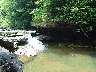
Laurel Creek is a tributary of Goose Creek river in Clay County in the U.S. state of Kentucky. It is 7.5 miles (12.1 km) long. The name comes from the proliferation of mountain laurel on its riverbanks.
Ogle is an unincorporated community in Clay County, Kentucky, United States. Ogle is located on Otter Creek Road 9 miles (14 km) south-southeast of Manchester. There is no town. It does not appear on the 1900 census, where people are listed rather as living in Otter Creek. The origin of the name is unknown. The Ogle post office was established in April 1893, with Morris Jackson as the first postmaster.
Garrard is a coal town in Clay County, Kentucky, United States on the junction of United States Highway 421 and Kentucky Highway 80, 2.5 miles (4.0 km) south of Manchester.
Wildcat was the post office serving Wildcat Creek in Clay County, Kentucky, United States. Traditional accounts are that the creek was named in 1815 for wild cats, the favourite target for hunters who settled there. The postoffice itself was established on 1930-09-13 by first postmaster Lillie B. Hacker, located at the mouth of the creek, and closed in August 1985.
Horse Creek is a tributary of Goose Creek river in Clay County in the U.S. state of Kentucky. The Cumberland and Manchester Railway built a spur line up the creek, and it has been the site of operations of at least eight coal mining companies. The name comes, according to local tradition, from the proliferation of "horseweed" in the creek valley.
Sextons Creek river in Clay County in the U.S. state of Kentucky is a tributary of the South Fork of Kentucky River in neighbouring Owsley County, Kentucky. It was named for a Sexton family of settlers who arrived some time before 1815.
Eriline was a post office in Clay County, Kentucky, United States from 1902-12-09 to 1988, with a 32-year hiatus from 1911. It was supposed to be named after Eveline Britton (1861–1939), wife of Van Britton (1855–1911) its first postmaster, but the clerks at the USPS could not read the handwriting on the application form, naming it Eriline instead, and the Brittons did not consider it important enough to make a fuss about the name.
Buchanan, originally named Mouth of Bear, is an unincorporated community located in Lawrence County, Kentucky, United States at the mouth of Bear Creek where it joins the Big Sandy River, five miles downstream from the mouth of Blaine Creek.
Marcum was a post office in Clay County, Kentucky from March 11, 1908 to June 1984.
Big Creek is a 4.5 miles (7.2 km) long creek in Kentucky, United States whose headwaters are in Leslie County and that flows into the Red Bird River in Clay County. A postoffice and village are named for it. Its own name is likely purely descriptive of its frequent flooding and high water levels, as it is not otherwise one of the biggest tributaries of Red Bird River.
Fall Rock is an unincorporated community in Clay County, Kentucky, United States. They are located on the Morgan Branch tributary of Laurel Creek, just under 1 mile upstream from the branch mouth, on United States Highway 421, the school across the road from the post office.
Goose Creek is a stream in Clay County in the U.S. state of Kentucky. It is one of two tributaries at the head of the South Fork of the Kentucky River, the other being the Red Bird River. It is 40 miles (64 km) long.
Bear Creek is a stream Clay County, in the U.S. state of Kentucky. It is a tributary of Red Bird River.
Collins Creek, also known as Collins Fork, is a tributary of Goose Creek in Clay County in the U.S. state of Kentucky. It is 9 miles (14 km) long; is named for its first settler James Collins, a salt maker and hunter; joins Goose just south of Garrard; and is paralleled by road and railway for most of its course.
Martins Creek is a tributary of Goose Creek in Clay County in the U.S. state of Kentucky that used to have a Martins Creek post office. It is 4.5 miles (7.2 km) long and named for early settler Salathiel Martin.
Beech Creek is a tributary of Goose Creek in Clay County in the U.S. state of Kentucky. It is just under 6 miles (9.7 km) long and joins the Goose approximately 1⁄2 mile (0.80 km) below the mouth of Laurel Creek.
This page is based on this Wikipedia article Text is available under the CC BY-SA 4.0 license; additional terms may apply. Images, videos and audio are available under their respective licenses.