Livermore, Iowa

Last updated
Livermore, Iowa
Livermore, Iowa 003.jpg
City Hall in Livermore
Humboldt County Iowa Incorporated and Unincorporated areas Livermore Highlighted.svg
Location of Livermore, Iowa
Coordinates: 42°52′1″N94°11′3″W / 42.86694°N 94.18417°W / 42.86694; -94.18417 Coordinates: 42°52′1″N94°11′3″W / 42.86694°N 94.18417°W / 42.86694; -94.18417
Country Flag of the United States.svg  United States
State Flag of Iowa.svg  Iowa
County Humboldt
IncorporatedMarch 11, 1882
Area
[1]
  Total0.69 sq mi (1.78 km2)
  Land0.69 sq mi (1.78 km2)
  Water0.00 sq mi (0.00 km2)
Elevation
1,142 ft (348 m)
Population
 (2020)
  Total381
  Density556.20/sq mi (214.61/km2)
Time zone UTC-6 (Central (CST))
  Summer (DST) UTC-5 (CDT)
ZIP code
50558
Area code 515
FIPS code 19-45975
GNIS feature ID0458536
Website www.livermoreiowa.org

Livermore is a city in Humboldt County, Iowa, United States. The population was 381 at the time of the 2020 census. [2] Livermore is the hometown of former University of Iowa and NFL tight end Dallas Clark.

Contents

History

1890 log cabin in Old Settlers Park Old Settlers Park, Livermore, IA 001.jpg
1890 log cabin in Old Settlers Park

Livermore was founded in 1879. [3] The community grew in importance as an agricultural center with grain elevators and feed mills and merchants serving the surrounding rich farmland. The community is located adjacent to the confluence of the East Fork Des Moines River and Lott's Creek. Early industries included a brick and tile factory and agricultural products processing. As north central Iowa's rural population dwindled, so has Livermore's population. Its remaining elementary school closed in 2005.

Geography

Livermore is located at 42°52′1″N94°11′3″W / 42.86694°N 94.18417°W / 42.86694; -94.18417 (42.866849, -94.184051) [4] at the confluence of Lotts Creek with the East Fork Des Moines River.

According to the United States Census Bureau, the city has a total area of 0.70 square miles (1.81 km2), all land. [5]

Climate

Livermore has a humid continental climate (Köppen Dfa), including all four seasons characterized by harsh winters, and mild summers.

July is the hottest month of the year, with an average high of 84 °F (29 °C) and an average low of 62 °F (17 °C). Temperatures above 100 °F (38 °C) are uncommon. January is the coldest month with an average high of 25 °F (−4 °C) and an average low of 7 °F (−14 °C). The city's highest temperature was 104 °F (40.0 °C), recorded in 1982. The lowest temperature recorded was −33 °F (−36 °C), in 1985.

Climate data for Livermore, Iowa
MonthJanFebMarAprMayJunJulAugSepOctNovDecYear
Record high °F (°C)63
(17)
67
(19)
87
(31)
95
(35)
98
(37)
104
(40)
102
(39)
100
(38)
98
(37)
95
(35)
19
(−7)
65
(18)
104
(40)
Average high °F (°C)25
(−4)
31
(−1)
44
(7)
59
(15)
72
(22)
81
(27)
84
(29)
81
(27)
74
(23)
62
(17)
43
(6)
29
(−2)
57
(14)
Average low °F (°C)7
(−14)
14
(−10)
25
(−4)
37
(3)
49
(9)
58
(14)
62
(17)
60
(16)
50
(10)
38
(3)
25
(−4)
12
(−11)
36
(2)
Record low °F (°C)−33
(−36)
−31
(−35)
−22
(−30)
6
(−14)
25
(−4)
34
(1)
41
(5)
37
(3)
25
(−4)
14
(−10)
−14
(−26)
−26
(−32)
−33
(−36)
Average precipitation inches (mm)0.88
(22)
0.80
(20)
2.16
(55)
3.28
(83)
3.89
(99)
4.79
(122)
4.29
(109)
4.12
(105)
2.95
(75)
2.28
(58)
1.74
(44)
1.07
(27)
32.25
(819)
Average snowfall inches (cm)5.3
(13)
6.0
(15)
5.4
(14)
0.5
(1.3)
0
(0)
0
(0)
0
(0)
0
(0)
0
(0)
0.1
(0.25)
2.1
(5.3)
6.8
(17)
26.2
(65.85)
Average precipitation days (≥ 0.01 in Days)2.53.04.15.66.87.35.76.65.63.52.82.856.3
Source: Weatherbase [6]

Demographics

Historical populations
YearPop.±%
1880 168    
1890 459+173.2%
1900 618+34.6%
1910 578−6.5%
1920 648+12.1%
1930 666+2.8%
1940 736+10.5%
1950 615−16.4%
1960 545−11.4%
1970 510−6.4%
1980 490−3.9%
1990 436−11.0%
2000 431−1.1%
2010 384−10.9%
2020 381−0.8%
Source: "U.S. Census website". United States Census Bureau . Retrieved 2020-03-29. and Iowa Data Center
Source:
U.S. Decennial Census [7] [2]

2010 census

As of the census [8] of 2010, there were 384 people, 164 households, and 106 families residing in the city. The population density was 548.6 inhabitants per square mile (211.8/km2). There were 197 housing units at an average density of 281.4 per square mile (108.6/km2). The racial makeup of the city was 96.9% White, 0.5% African American, 0.3% Native American, 1.0% from other races, and 1.3% from two or more races. Hispanic or Latino of any race were 2.3% of the population.

There were 164 households, of which 28.0% had children under the age of 18 living with them, 49.4% were married couples living together, 8.5% had a female householder with no husband present, 6.7% had a male householder with no wife present, and 35.4% were non-families. 29.3% of all households were made up of individuals, and 14.6% had someone living alone who was 65 years of age or older. The average household size was 2.34 and the average family size was 2.83.

The median age in the city was 41 years. 24.5% of residents were under the age of 18; 3.8% were between the ages of 18 and 24; 27.1% were from 25 to 44; 28.7% were from 45 to 64; and 15.9% were 65 years of age or older. The gender makeup of the city was 49.7% male and 50.3% female.

2000 census

As of the census [9] of 2000, there were 431 people, 183 households, and 109 families residing in the city. The population density was 616.4 inhabitants per square mile (238.0/km2). There were 204 housing units at an average density of 291.7 per square mile (112.6/km2). The racial makeup of the city was 99.77% White and 0.23% Pacific Islander. Hispanic or Latino of any race were 0.46% of the population.

There were 183 households, out of which 29.5% had children under the age of 18 living with them, 45.9% were married couples living together, 7.7% had a female householder with no husband present, and 39.9% were non-families. 35.0% of all households were made up of individuals, and 23.0% had someone living alone who was 65 years of age or older. The average household size was 2.35 and the average family size was 2.94.

In the city, the population was spread out, with 23.9% under the age of 18, 8.4% from 18 to 24, 25.5% from 25 to 44, 24.1% from 45 to 64, and 18.1% who were 65 years of age or older. The median age was 42 years. For every 100 females, there were 89.0 males. For every 100 females age 18 and over, there were 95.2 males.

The median income for a household in the city was $26,328, and the median income for a family was $32,411. Males had a median income of $25,789 versus $19,583 for females. The per capita income for the city was $13,714. About 10.6% of families and 12.6% of the population were below the poverty line, including 7.2% of those under age 18 and 14.5% of those age 65 or over.

Education

It is within the Twin Rivers Community School District. [10]

Community

Sacred Heart Catholic Church in Livermore Livermore, Iowa 004.jpg
Sacred Heart Catholic Church in Livermore

With a sizeable German Catholic population surrounding Livermore, the community's largest church is Sacred Heart Catholic, followed by Livermore United Methodist and Immanuel Lutheran. Bethel Presbyterian Church closed in the late 1970s and the building is now home to the Livermore Community Club and museum. Other community attractions include Old Settlers' Park, which dates to 1890, when early Livermore families each contributed a log to build a cabin in the thickly wooded park located at the west entrance to the community. The town also features a library, community swimming pool and a high school baseball/softball complex. Just north of Livermore is the picturesque Spring Valley Golf Club, named Iowa's best nine-hole course, before it was expanded to 18 holes. Otto Field American Legion Post 415 is located in Livermore and the town's Friends & Neighbors Club is an active seniors organization with its own building. Livermore Daze is an annual celebration that brings together antique car enthusiasts, parade participants and hundreds of residents and visitors to the weekend event.

Notable person


Related Research Articles

<span class="mw-page-title-main">Humboldt County, Iowa</span> County in Iowa, United States

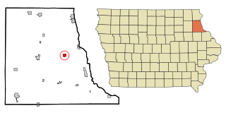
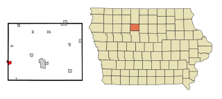
Humboldt County is a county in the U.S. state of Iowa. As of the 2020 census, the population was 9,597. The county seat is Dakota City. The county was created in 1857 and named in honor of Alexander von Humboldt.

<span class="mw-page-title-main">Fulton, Illinois</span> Place in Illinois, United States

Fulton is a city in Whiteside County, Illinois, United States. The population was 3,481 at the 2010 census, down from 3,881 in 2000. Fulton is located across the Mississippi River from Clinton, Iowa.

<span class="mw-page-title-main">Anita, Iowa</span> City in Iowa, United States

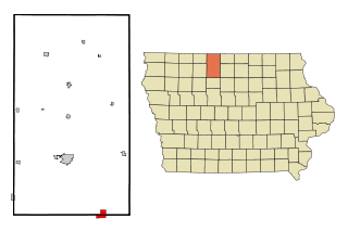
Anita is a city in Cass County, Iowa, United States, platted in 1869 and incorporated in 1875. The population was 963 at the 2020 census. Lake Anita State Park is located just outside the town.

<span class="mw-page-title-main">Garnavillo, Iowa</span> City in Iowa, United States

Garnavillo is a city in Clayton County, Iowa, United States. The population was 763 at the time of the 2020 census, up from 754 in 2000.

<span class="mw-page-title-main">Bode, Iowa</span> City in Iowa, United States

Bode is a city in Humboldt County, Iowa, United States. The population was 302 at the 2020 census.

<span class="mw-page-title-main">Bradgate, Iowa</span> City in Iowa, United States

Bradgate is a city in Humboldt County, Iowa, United States, at the conjunction of Sections 5, 6, 7, and 8 of Avery Township, and rests near the banks of the West Fork of the Des Moines River. The population was 75 in the 2020 census, a decline from 101 in 2000.

<span class="mw-page-title-main">Dakota City, Iowa</span> City in Iowa, United States

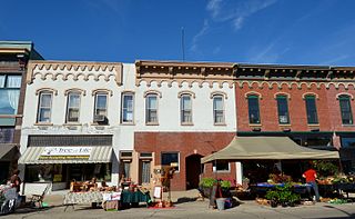
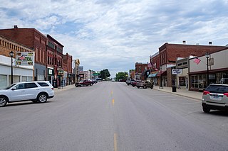
Dakota City is a city in, and the county seat, of Humboldt County, Iowa, United States. The population was 759 at the time of the 2020 census. Dakota City shares its western border with the much larger city of Humboldt. It is the least populous county seat in Iowa.

<span class="mw-page-title-main">Hardy, Iowa</span> City in Iowa, United States

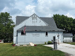
Hardy is a city in Humboldt County, Iowa, United States. The population was 57 at the time of the 2020 census.

<span class="mw-page-title-main">Pioneer, Iowa</span> Unincorporated community in Iowa, United States

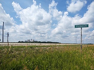
Pioneer is an unincorporated community in Humboldt County, Iowa, United States. The population was 4 at the time of the 2020 census, and elected to unincorporate as a municipality in 2020.

<span class="mw-page-title-main">Renwick, Iowa</span> City in Iowa, United States

Renwick is a city in Humboldt County, Iowa, United States. The population was 234 at the time of the 2020 census.

<span class="mw-page-title-main">Rutland, Iowa</span> City in Iowa, United States

Rutland is a city in Humboldt County, Iowa, United States. The population was 113 at the time of the 2020 census.

<span class="mw-page-title-main">Thor, Iowa</span> Town in Iowa, United States

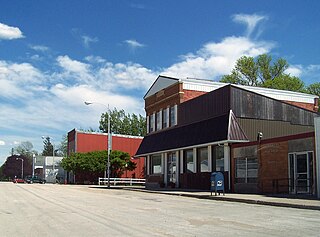
Thor is a town in Norway Township, Humboldt County, Iowa, United States. The population was 181 at the time of the 2020 census.

<span class="mw-page-title-main">Lone Rock, Iowa</span> City in Iowa, United States

Lone Rock is a city in Kossuth County, Iowa, United States. The population was 146 at the time of the 2020 census. The city is named after a large boulder.

<span class="mw-page-title-main">Titonka, Iowa</span> City in Iowa, United States

Titonka is a city in Kossuth County, Iowa, United States. The population was 511 at the time of the 2020 census.

<span class="mw-page-title-main">Earlham, Iowa</span> City in Iowa, United States

Earlham is a city in Madison County, Iowa, United States. The population was 1,410 at the time of the 2020 census. It is part of the Des Moines–West Des Moines Metropolitan Statistical Area.

<span class="mw-page-title-main">Hancock, Iowa</span> City in Iowa, United States

Hancock is a city in Pottawattamie County, Iowa, United States, along the West Nishnabotna River. The population was 200 at the time of the 2020 census.

<span class="mw-page-title-main">Vincent, Iowa</span> City in Iowa, United States

Vincent is a city in Webster County, Iowa, United States. The population was 130 at the time of the 2020 census.

<span class="mw-page-title-main">Woolstock, Iowa</span> City in Iowa, United States

Woolstock is a city in Wright County, Iowa, United States. The population was 144 at the time of the 2020 census.

<span class="mw-page-title-main">Gilmore City, Iowa</span> City in Iowa, United States

Gilmore City is a city in Humboldt and Pocahontas counties in the U.S. state of Iowa. The population was 487 at the time of the 2020 census.

<span class="mw-page-title-main">Lu Verne, Iowa</span> City in Iowa, United States

Lu Verne is a city in Humboldt and Kossuth counties in the U.S. state of Iowa. The population was 258 at the time of the 2020 census.

References

  1. "2020 U.S. Gazetteer Files". United States Census Bureau. Retrieved March 16, 2022.
  2. 1 2 "2020 Census State Redistricting Data". census.gov. United states Census Bureau. Retrieved 12 August 2021.
  3. History of Kossuth and Humboldt Counties, Iowa. Union Publishing Company. 1884. p.  838. Note that Google Books misspells "Humboldt".
  4. "US Gazetteer files: 2010, 2000, and 1990". United States Census Bureau. 2011-02-12. Retrieved 2011-04-23.
  5. "US Gazetteer files 2010". United States Census Bureau. Archived from the original on 2012-07-02. Retrieved 2012-05-11.
  6. "Average Number of Rainy Days - Algona, Iowa" (Graph). CantyMedia. Retrieved August 6, 2017.
  7. "Census of Population and Housing". Census.gov. Retrieved June 4, 2015.
  8. "U.S. Census website". United States Census Bureau . Retrieved 2012-05-11.
  9. "U.S. Census website". United States Census Bureau . Retrieved 2008-01-31.
  10. "Twin Rivers" (PDF). Iowa Department of Education . Retrieved 2020-03-27.
  11. "Dallas Clark profile". National Football League. Retrieved January 21, 2011.